


theuselesseater
-
Posts
12 -
Joined
-
Last visited
Content Type
Forums
Blogs
Gallery
Events
Learn About Weather and Meteorology
Community guides
Posts posted by theuselesseater
-
-
Even the ECM has a low out in the Atlantic at T240, but with the blocking where it is, it IMHO will probably slide over Southern Frab=nce Northern Iberia. This cold will take some shifting, and will take some intense mixing out
All the time the North Sea is getting colder than it has in years.
And we are still EARLY in winter, theoretical Mid winter 10-12 days away. Normal winter coldest weather still 18-23 days away
To add, quickly...the GFS nearly always over devlops lows in the atlantic out past 144, it's akin to throwing its hands in the air and saying WTF....
Suffice, to say...ECM remains top for trend verifcation so far.
PS - That's not to say that at some point the GFS wont pick up a new signal first, however, that signal is NOT in the foreseeable future at the moment.
Enjoy...
TUE - J
-
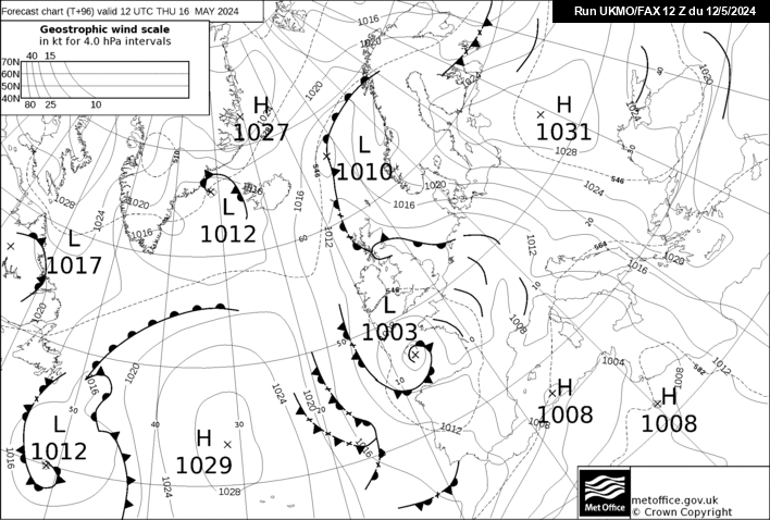
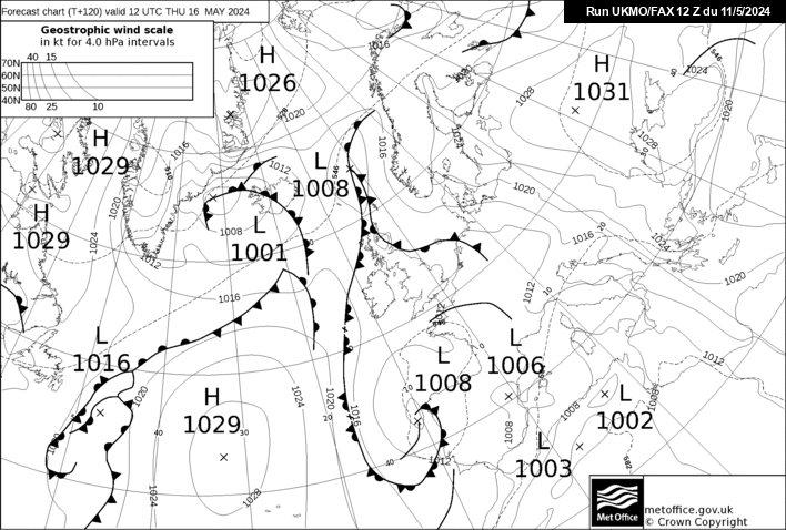
I know many to the south of me will now be salivating at the white fairy dust falling from the sky, but up here in not so snow drenched Suffolk I've been looking at the latest Fax charts for 96 (Sat) and 120 (Sun)...
You would, wouldn't ya...:lol:
PS - Of course modifications will be made to these charts, but the general theme for the coming days looks nice indeed...
TUE -J
-
For those of you further north than south Essex the keyword is Patience....
Good things come to those who...........:lol:
Tomorrow afternoon/evening onwards should start to present some spanking opportunities for the white stuff...
TUE - J
-
not one snow flake in sufffolk !!!! loads of warning for later in the week but i cant wait!!
Patience, my boy...
Good things come to those who.........
The potential for EA after tonight's 'Little' (cough) mishap further south is rather spanking
Tue - J
-
MetO have now upgraded Kent to orange. That just seems to leaves Norfolk, Suffolk, Cambridgeshire and
 Essex
EssexWishful thinking for tonight...
Tomrrow night onwards...game on for those areas...
TUE - J
-
Hopefully more people will be happier with the latest NE developments...
OT, but a CAPITAL T forTasty with this little fella from the UKMO...
Nice...
TUE - J
-
This is my take on things guys.
This Area IMO is where the snowfall could be immense.
Comments welcome
I'd lift the southern edge slightly, but might not be far wrong....
Bottom line is there will be plenty of PPN across large swathes of the south/se etc etc...
Enjoy...
TUE - J
-
Certainly becoming more interesting for those further north/east as hinted at earlier...
Expect further eastward drift as we move on in, fascinating really...
Charts going forward aren’t have bad either...
TUE - J
-
http://news.bbc.co.u...node&state=vi:V
Latest from Bbc I-Player
Click Forecast Video and Play Button
I think most will be pleased with that Forecast including London and Herts/Surrey but looks like my nagging fear of Coastal Essex, Coastal Suffolk, Eastern Kent and Norfolk looks likely to happen with little or no snow and now have to rely on Showers at the end of the week, the Front further North looks like it merges with the Snow in the West of our region and then fizzles out during Wednesday Night and early doors thursday.
Paul S
It is still a complex situation as to what happens into EA later tonight/tomorrow, expect upgrades later
Having said that, Suffolk is not my first choice location right now, just need an excuse for a trip down south
TUE - J
-
Who said things look mainy dry.....
Go WEST...nuff said...
Expect a slight eastward revision on the 18z & 00z.....
BUT, a nice run ensuring *most* get some white stuff
Any takers for the GME...
TUE - J
-
I am beginning to highly suspect that NOAA has reverted to running the 06z output via an Amiga 64...the operational output of this particular run has been often somewhere between goofy and ridiculous.
The 06z short/mid term evolution is suspect, at this point I'd say it gets a big fat NO...although it does bring a nice easterly along down the road...
ECM/UKMO/GEM all still looking nice, with the UKMO looking particularly tasty still...
http://www.meteociel...44-21.GIF?04-05
http://www.meteociel...20-21.GIF?04-05
http://www.meteociel...96-21.GIF?04-05
We seem to be stuck in a Alice in wonderland type of situation....heads we win tails they lose, by that I mean that whatever the evolution we will remain cold or very cold.
What more can you ask for in winter...
PS: Interactions later this week are key, Expect a revision for the 12z & 18 GFS....
PPS: GFS - Other models ARE available
TUE...
 Essex
Essex


East Anglia & South East Cold Spell Discussion
in Spring Weather Discussion
Posted
It's tantalislingly close to Ipswich really, Southern districts over and along the Orwell Bridge/A14 should be getting something light now.
To those in Colchester/south Suffolk, big breath now and blow north...Please
TUE - J