


SouthernSnowFan
-
Posts
23 -
Joined
-
Last visited
Content Type
Forums
Blogs
Gallery
Events
Learn About Weather and Meteorology
Community guides
Posts posted by SouthernSnowFan
-
-
9 minutes ago, khodds said:
Evening all, gosh it’s quiet in here!
They're all in the mod thread! 10 day chase has started again...
-
 5
5
-
-
There were a few sweet spots (Eastern coats/higher ground in Scotland) who bore the brunt, and I'm pleased for some areas of the South East and East Anglia in particular who saw some of their best snowfall for many a year.
I still can't class it as a beast though. This wasn't a nationwide event, the impacts were extremely localised and very much focused on the eastern extremities. Whilst the rest of us felt cold, we only had a few days with flakes flying around in the air to appease our snow cravings!
Down in my part I'll give this a 1/10. No ice, no frost, no laying snow. Just 1 or 2 days with flakes flying around in the air.
-
1
-
-
There were a line of showers geared for Southampton not so long ago, typically they petered out and shifted south. Although stop the press, I think I saw a flake in the wind! That pretty much summed up this 'beast' in these parts. More like a kitten.
Overall another incredibly cold day. Nice bursts of sunshine as well.
Still hoping for some snow at the weekend, but the holy grail for us South coasters is a channel low - who knows, we may get lucky over the coming weeks.
-
3
-
-
It would feel such a waste to have to endure such cold air but actually get nothing from it bar some flakes floating around in the sky. No frost, no ice, no laying snow (in this part anyway)
I'm still holding out hope for a battleground scenario, but even that looks slim for most of us now. Feels like we will just transition silently into milder air and bring in the inventible rain, which obviously won't miss us!
-
4
-
-
I'm not sure I can class what we saw in Southampton overnight as 'snow'. I notice the local Daily Echo has a live blog on it, which I found a bit insane.
Struggling to see anything this week for us, just looking for the breakdown and how this pans out.
Still of the view we will remain in colder air until next week - this is just my hunch though. Only downside of that is it will be bone dry.
It's been a really odd cold spell so far, impact very, very localised to the eastern extremities. Temps down into minus figures, overcast and grey for the rest of us meaning absolutely no moisture. No frost, no ice, nothing. Just horrible grey cold rubbish.
Still, there's a long way to go. I remember some memorable march events down in these parts.
-
1
-
-
Can anyone get to this page?
 Southampton Weather - Live Weather Updates from Southampton Centre
WWW.SOUTHAMPTONWEATHER.CO.UKOfficially the most up-to-date weather reporting live from Southampton. With the very latest forecasts, charts, weather tv, marine info, astronomy and much more.
Southampton Weather - Live Weather Updates from Southampton Centre
WWW.SOUTHAMPTONWEATHER.CO.UKOfficially the most up-to-date weather reporting live from Southampton. With the very latest forecasts, charts, weather tv, marine info, astronomy and much more.I swear by this for temps and current conditions, but it seems to have gone down!
Does anyone know of any other Southampton based stations?
-
3 minutes ago, MidnightSnow said:
Don't wanna quote your entire post again AWD, but I think that's gotta be as good as it can get. Some miss out but I think that scenario would involve as many as possible.
Agreed, brings most into the game in this region. But it shows the clear risk of milder air encroaching for the southern contingent amongst us.
-
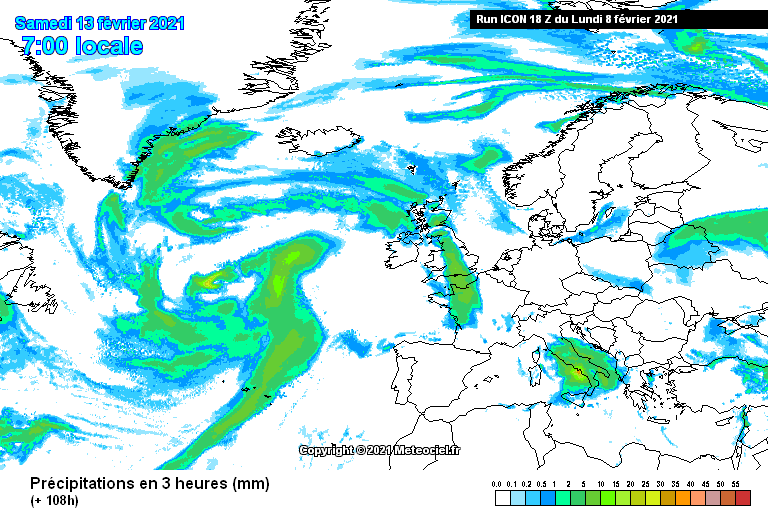
The uncertainty is perfectly illustrated in this graphic:
That shows a significant snow event right down the spine of the UK next Saturday, but it really is too far out to say that with any certainty. It really is on a knife edge.
This chart shows that it's making a really good go at getting in, which brings a greater chance of snowfall for more...but also introduces the risk of milder air making more inroads. It is a really, really delicate balancing act. I really can't call it to be honest, could go 1 of 3 ways.
- Front stalls west, no further than Devon - far SW could get a decent snow event from that. Rest of us stay in cold air, but remain bone dry.
- Front makes more inroads east, snow for more along the central southern area - and further north - but introducing milder air for those further south and west - comes with that risk.
- Front blasts through very quickly, and gives a quick transitionary snow event for most before rain is the name of the game for all.
My money is on the first outcome.
-
2
-
-
Just now, Wiltshireweatherwatcher said:
First it was Thursday, then it was Friday, now it’s Saturday and marginal at that. The models are having a hard time pinning down who wins, the Atlantic or the Easterly.
For me, the money is still on the 'cold block' holding out for the majority of the UK after this weekend.
The only downside to that is that it will remain dry for pretty much everyone.
To some of the more knowledgeable - what do we need to look for from the models in the short term, in order for this cold spell to create some instability/troughs etc? At the moment it looks pretty bland for the entire country.
-
1
-
-
1 minute ago, MagicOtter said:
Rain probably - cold, cold rain
It almost certainly wouldn't be rain if that did clip the southern coasts.
-
1
-
-
1 minute ago, Frank Trough said:
i think it was this you're thinking of?
I was in Locks Heath then. Brilliant event that was - had to abandon my car in Bursledon tesco and walk the rest of the way home from work.
That's the one, we had another event later on in January but it was that one early on which was newsworthy.
We had cars dumped absolutely everywhere, no one could move. Going by that, it looks to have been a forecast front so not an 'unexpected' event as such.
What I'd give for something similar!
-
3
-
-
It was touched on yesterday, but I'm really interested to know what brought that epic dumping in January 2010 to our parts? (The dumping which was suggesting 40cm for Southampton, it was lowered to around 15-20cm though).
Thinking back that far, it feels as if this was quite an evolving situation but for the life of me, I cannot remember what the forecasts or models were showing for this. None of the historic threads in the model forum go back that far either.
I'm just clutching at straws really, what do we need for a similar event? Was it a channel low that pushed a touch further north and ran across the southern quadrant?
-
1
-
-
Little bit more intensity in the Central Southampton area at the moment, still very, very light in the main and thus struggling to settle on anything, but it's a noticeable pick up from what was floating around earlier.
-
2
-
-
3 minutes ago, CentralSouthernSnow said:
I’m logging off till next winter, that’s me done guys! So much potential but unfortunately poor show for us in the south/southwest. Unfortunately flurries don’t excite me! We could of had a snow event Friday as our last chance but Atlantic isn’t making it in. All the best till next winter
You'll be back tomorrow to share your snow pics.
-
1
-
-
4 minutes ago, clark3r said:
This is really turning into a poor show, it’s bitter yes but the snow in my area is pathetic, radar looks pretty dull at the moment
Could get more interesting into tonight/tomorrow as the winds veer, you'll see more convective activity. It will become very much a nowcast, stuff popping up when least expected. This is what happens when you get the cold air in situ for a couple of days.
-
1
-
-
7 minutes ago, The Moving Planet said:
Actually after looking at the wind direction and speed of the wind which will pick up I think there is a chance of something more noticable this evening and tomorrow. Were still in the game yet.
Is this what you've seen?
Looks very interesting for most of the Southern half of our region. Snow starved south coast!
Does look quite light in nature, but it may pep up?
-
2
-
-
4 minutes ago, Thundery wintry showers said:
Nowt here as expected, and chances for Tuesday and Thursday/Friday appear to be receding, though the latest GFS run shows some light snowfall for around here early on Thursday.
It does seem like it's going to turn out a very cold, but incredibly dry spell for most in the main. I think we kind of want a breakdown attempt from the west, just to give us all a fix - but those chances are drifting away as well. Looks very possible (although can still change) that we may be just fade out of cold into milder air which will then allow the Atlantic fronts to come in, immediate rain. No events.
Still have to make the most of this week though, things may crop up at short notice.
-
1
-
-
Just now, That ECM said:
It's said that for Southampton since yesterday as well. Where on earth is it getting it from?
Shows how little notice people should make of these websites/apps.
-
1 minute ago, matt111 said:
Weird, I'm about 10mins - if that - from that location and diddly squat here. Shows how insanely localised these showers can be. Can't even see that on the radar!
-
3
-
-
2 minutes ago, CentralSouthernSnow said:
I’d rather mild and mush or marginal snow then just dry and cold... this winter really hasn’t been great
It's not been bad in the main, tons better than last year. The fact remains that this is day 1 of a prolonged cold spell...we're not even in it proper yet! No clear signs of a breakdown yet, whilst it looks dry there are always chances of things cropping up at short notice. Once the 'storm' has cleared out of the way and the winds veer more direct E, we may see more shower development. One to keep an eye on through tomorrow anyway.
-
2
-
-
3 minutes ago, CentralSouthernSnow said:
Have you all seen the 18z it looks a mess and blocking failing. Lol this winter I think I’ll almost be done soon! I just wanted one snow day in the south west
Yeah, only one run though. Really isn't worth micro analysing each and every run as some people do. Just sit back and see how it unfolds.
General trend is for it to remain on the cold and dry for most of the month. Not exciting at all, but much better than 'mild wet mush' we usually get.
-
4
-
-
- Popular Post
- Popular Post
Hi All - long time lurker around these parts - finally thought I'd post though.
It does look like we are heading for quite a prolonged cold spell, but is it just me...or does it look generally pretty dry? Maybe I'm not reading the models right?? (Certainly for my neck of the woods anyway).
It always feels as if we are in a bit of a no mans land along the Hampshire South Coast! Too far west for events such as todays, too far east for attempted breakdowns from the west, too far south to take in any real streamer fun (they seem to fizzle out around Winchester) and too far north to get into any fun and games from a channel streamer.
What do you guys feel is the best chance for the snow starved South Coast to get in on some significant action? I remember 2010 and 2009 very fondly, we were even under a red warning for a period of time - but my memory isn't great in my old age nowadays, so I can't quite remember what the setup was for that!
-
9
-
 1
1


Winter 2022/23 - Moans, Ramps & Chat
in Spring Weather Discussion
Posted
I know it's an old saying, but getting the cold in is the first piece of the puzzle for us in the UK. And we are currently seeing quite a prolonged and somewhat brutal cold spell modelled.
What we are seeing with the front approaching next week is an attempt for it to barge across us, but the models are struggling to interpret how the block is going to interact with that. My hunch is that it will interact with the far SW contingent and then retreat back as the cold encroaches from the east - potential for a decent event in the far SW I'd say.
The best snow events in my neck of the woods (central southern) have always been last min forecast events (circa 48hrs) which have cropped up and have interacted with the cold air already well in situ. I think it's much more of a risk longevity wise to want that low to encroach on us too much, you encourage too much mild air into the mix, it becomes a marginal mess, starts to erode the block and what we end up would not be much more than a little cold snap. 'If' the the cold block pushes it away like it seems to be being modelled to, then our long term hopes for quite an entrenched cold spell increase dramatically in my opinion, and in that so does everyone's chances of snow events.