


DT-wxrisk
-
Posts
10 -
Joined
-
Last visited
Content Type
Forums
Blogs
Gallery
Events
Learn About Weather and Meteorology
Community guides
Posts posted by DT-wxrisk
-
-
THis site.l.. which I have been using for a while is down
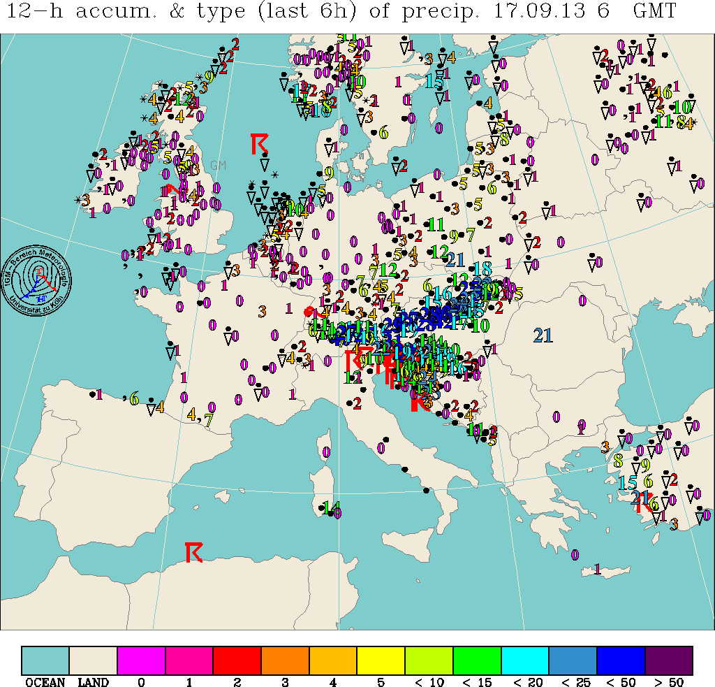
http://www.meteo.uni-koeln.de/meteo.php?show=En_We_We
its obviously down which is terrible shame as they had great data and 24 hours rainfall maps for ALL of Europe.
I am an energy / Grain meteorologist and I kind of need those rainfall maps
http://www.uni-koeln.de/math-nat-fak/geomet/meteo/winfos/precieuropa06.gif
http://www.uni-koeln.de/math-nat-fak/geomet/meteo/winfos/precieuropa18.gif
as you can see these rainfall maps have NOT been updated in a few days...
so does anyone know of any rainfall for maps for Europe ?
By that I mean ACTUAL rainfall over the last 24 hours?
DT
wxrisk.com
Richmond VA USA
-
Sorry folks but the fact is Joe B is a clown and Hypster of the first order.
2 weeks ago That Moron was banging the drum about how it was going to turn MUCH colder after NOV 15....
instead we are looking at temps i the 60s and 70s over MUCH of the eastern CONUS NOV 20-30....
Hi G.P,
There is a lot of talk over on Weatherbell (Joe B and Joe D) concerning a pattern change early December (obviously this is skewed towards the US) though they are expecting a rise in heights over southern Greenland:
For a change the ensemble means provide a more realistic solution with the North Pacific cold trough with an axis extending south west of 150W. Note the warmth in northeast Canada and southern Greenland reflected a tendency for blocking. Also the nosing ridge feeding the Great Basin high which helps deflect cold air south the east.

The spaghetti chart which shows the 516, 546, 576 and 588 gpm height contours for each of the 21 ensemble members. Climatology is shown in green and ensemble mean in orange for those contours. White depicts the operational 18Z run. See how again the op run was an outlier. The majority of members are suggesting a central US trough which corresponds to the Pacific trough location anchor.
One of these days soon, the op runs will reflect a change colder late this month and early December.
BTW, this is the second straight GFS ensemble showing this tendency. It has more eastern Canada blocking.
See 16 of the individual members. Almost a third were impressively cold..
I note that the emphasis of these discussions are in relation to the US situation, but a pattern change nevertheless. Just wondered what your thoughts were or, if I have (most likely) latched onto the wrong end of the stick.
Interesting that the Weatherbell talk over recent days has been for December cold to begin to take hold (US) with a gradual cooling of central Europe into the NorthWest later ...... sounds possible this may be similar to your own thoughts but just a little sooner ?
Cheers
Y.S
-
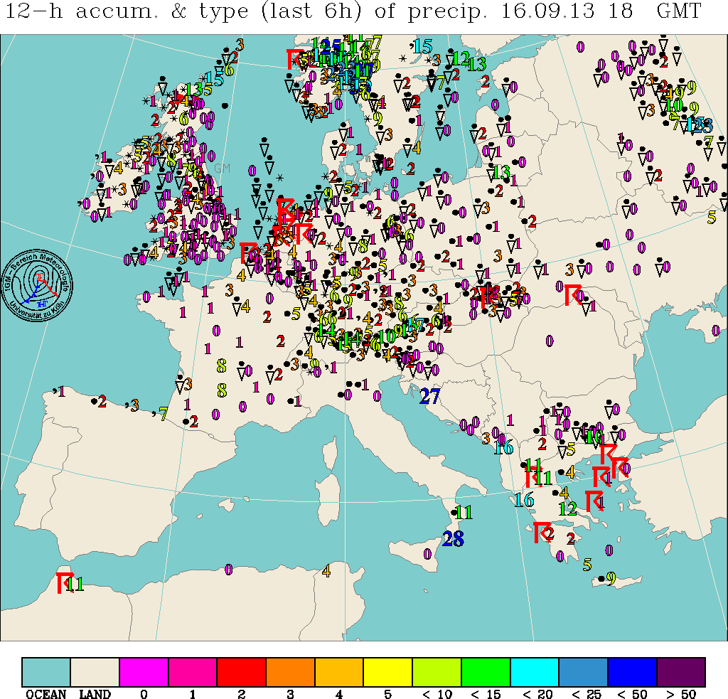
http://www.meteo.uni-koeln.de/meteo.php?show=En_We_We
its obviously down which si terrible shame as they had great data and 24 hours rainfall maps for ALL of Europe.
I am an energy / Grain meteorologist and I kind of need those rainfall maps
http://www.uni-koeln.de/math-nat-fak/geomet/meteo/winfos/precieuropa06.gif
http://www.uni-koeln.de/math-nat-fak/geomet/meteo/winfos/precieuropa18.gif
as you can see these rainfall maps have NOT been updated in a few days...
BTW anyone know of any rainfall for maps for Europe ?
By that I mean ACTUAL rainfall over the last 24 hours?
DT
wxrisk.com
Richmond VA USA
-
It appears to have gone positive so far for Oct.
NAO +.32
AO +.25
PNA +.27
NAO will MNOT run negative this winter.
no way
Im really positive we will see a very negative nao, but even if the QBO is strengthening, 1979 produced the goods!
no WAY... the northern Pacific mslp are too and OCT NAO was postiive
research shows that when this happens.... since 1950 in every case but one the NAO for DJF was positive
-
It'll be interesting to see which gets closest in this LP situation coming up, my money's on ECM...
it always should be.
a few days ago the wretched GFS had this Low for next week hundreds of miles further N of where it is now showing this Low will track...
-
the CFS development of the Mod la Nina re-strenghtening is interesting and unexpected
Not sure what the term MONSTER means with respect to the La Nina. Over the past weeks the La Nina has leveled off and will not reach 'STRONG" criteria
It certainly looks like a monster La Nina is unstopable now. I wonder if this could also be an multi-year La Nina with a continuation through 2011 and second peak winter 2011-2012? A lot of the strongest La Nina's do seem to be spread over two or even three years;
1916/1917 & 1917/1918
1942/1943 & 1943/1944 & 1944/1945
1949/1950 & 1950/1951
1954/1955 & 1955/1956 & 1956/1957 (weak)
1973-1974 & 1974/1975 & 1975/1976
1998/1999 & 1999/2000 & 2000/2001 (weak)
The two events that didn't follow this pattern seem to be 1988/1989 and 2007/2008, both of which only lasted a single year.


Anyone Know Of Web Site That Has European Daily Actual Rainfall Totals?
in Weather Around The World
Posted
Thank .... but I have all those...
No what I am looking for are actual rainfall that ahs already fallwn... NOT a forecast map