


weatherobsuk
-
Posts
5,868 -
Joined
-
Last visited
-
Days Won
4
Content Type
Forums
Blogs
Gallery
Events
Learn About Weather and Meteorology
Community guides
Posts posted by weatherobsuk
-
-
This early morning's efforts from the phone
 at least two before the low-cloud and murk rolled in just as things were getting interesting. Under those clear skies above it was constant flickering for a time, especially noticeable when averting my vision just off-center. There was also a Sprite seen visually between some ACCAS which caught me off guard but just for seeing that alone the trip was worth it. The whole thing happened quicker than my brain could register what I was looking (like electric finger-ripples shooting upwards) and then it was gone, followed by a positive CG strike that lit the whole part of that sky.

-
 6
6
-
 1
1
-
-
A 7hr round trip and i'm finally back home after having a scenic tour of the Chilterns from Bicester, Oxford, and Benson. There was some close strikes at times during the early morning hours at 4am but the convective line frustratingly refused to move anymore northwards and I wasn't up for heading further south knowing it would take longer getting back. So with the twilight chorus and skies getting lighter I called it a night and headed back along the never-ending M40.
Here's hoping early morning Friday delivers for the East and North Midlands
-
1
-
2
-
-
Pulled off the phone so not the best quality (saving the M50ii battery for when things get nearer) but the anvil as it was approaching the South Coast is huge. It seems a lot of it has now gotten rain-wrapped with the cells that are currently developing the convective line.
-
1
-
-
Holy moly just saw my first Sprite
 (lightning not the drink) just missed out getting it on a timelapse as it was well above some ACCAS.
-
6
-
2
-
-
Seeing the occasional lightning flash to the SW here at Bicester now, hoping those cells now moving into East London use all the CAPE available to keep sustained until at least 4am.
-
After a 3hr drive I'm finally parked up near Bicester just as the first of the evenings cells begin to cross the channel. Compared to up north it definitely feels more humid and thundery in the air. Fingers crossed for the next few hours.
-
3
-
-
Brize Norton METAR looks interesting..
Temporary
from 02 at 01 UTC to 02 at 08 UTCVisibility: 2000 m
thunderstorm, rain, showers, small hail or snow pellets
METAR TAF : RAF Brize Norton, Brize Norton England
EN.ALLMETSAT.COM
METAR TAF : Current weather observation and Forecast, Brize Norton RAF Brize Norton England-
2
-
-
Frosty hollows Assuming the models remain consistent i'll be setting up shop NE of Oxford between the Costwolds & Chilterns, it's a almost a 3hr straight-run down the M1 from where I live and there's always the options of using the M40, A34, A420 just incase the system moves further south than modelled. Its the first chase in my new car so i'm hoping to avoid any hail cores whilst getting the best of any lightning show within the dry inflow. Good luck to y'all also out chasing later on.
-
5
-
-
I've been flipping between Reading, Portsdown Hill, Surrey Hills, and finally made a decision that i'll try and position closer to Bicester as google maps has come up trumps with a spot that has a expansive 180 view from the SE to SW. The problem chasing in the south is finding somewhere facing directly south that has parking and isn't surrounded by trees (ie. Surrey Hills).
The slight northerly trend and cells forming within the MSC boundary outflow puts me in good confidence that there'll at least be something to see away from the heavier PPN core, even if it's not a direct hit.
-
3
-
-
-
It sure is a tricky one to chase tonight as this morning's model runs have shifted things a bit south again, with the UKV now having a few home-grown storms breaking out over Reading at 2am to add to the complexity. The local METAR forecasts in the south aren't looking too promising with low-cloud bases (base level at 300ft with 1.8mi vis at Brize Norton for example) as the MSC complex becomes embedded within the warm-front.
It's looking less likely i'll be chasing now based on the visibility forecast, but if things change then it's 'only' a 4hr drive

-
WeatherArc Watching the Topeka live cam before it was evident the wall-cloud was spinning like crazy, just missed out on seeing the CC drop as the rain wrapped around that area of circulation north of downtown but luckily Reed was there just minutes afterwards for a confirmed visual.
-
1
-
-
Topeka
-
2
-
-
Topeka live cam looking at the area of interest
-
1
-
-
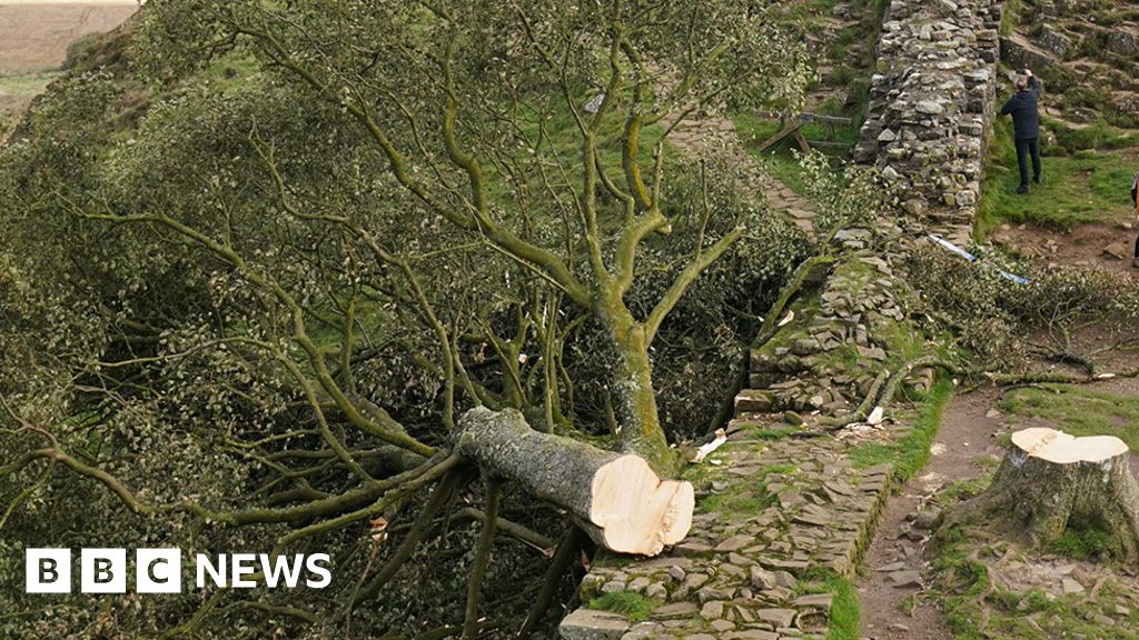
An update on the two inbreds who caused this needless damage.. I hope and pray they're given at least a minimum 200 hours of community service, each, to plant tree's under all weather conditions. No ifs or buts.
Two men charged over felling of Sycamore Gap tree
WWW.BBC.CO.UK
Two charged with causing criminal damage to the famous Sycamore Gap tree and Hadrian's Wall.-
1
-
-
UKV and NW-SR are continually pushing Wednesday night's convection further southwards with each run so it's difficult to pin-point the exact area i'd personally like to be intercepting the storms given the current uncertainty. If I had to make a guess (and a last-minute chase) i'd set-up somewhere around Thatcham and then use the M4 to quickly head west if needed, using the MWay to get as much time close to the core before it exits out over the Bristol Channel.
-
3
-
-
Its turning into quite a nice day here away from the blustery wind, there's a bit of milky skies to the west but it's almost completely-clear skies to the east with temps still on the rise above 14'c.
-
6
-
-
I'm tempted to head out in the new car and chase this one as it feels like a millennia since there's been any significant storms here in the NW, a more northerly component in the models would mean setting up somewhere in Norfolk but somewhere along the southeast coast is looking likely (assuming there's no MWay closures to get there.) Otherwise it'll be webcam watching and hoping something closer to home pops off towards the South Midlands.
-
1
-
-
Its looking nice outside this early morning although there's rain inbound for later this afternoon, somewhat turning blustery with 50mph likely over the high routes during the next 48hr before a brief respite into Wednesday. Already the weekend ahead has the potential to be another wash-out again so i'm not holding out any hope on seeing long-spells of sunshine anytime soon.
-
7
-
-
Max is currently livestreaming for tonight but after yesterday's 14hr youtube streaming marathon and with work tomorrow I won't be watching for too long this evening. The risk is still moderate and already some confirmed touchdowns within the risk area.
-
1
-
-
The poor residents of Sulphur, OK got hit pretty bad last night with not only two tornadoes tracking through town and another close-by, but also 8" of torrential rain over a 6hr period that caused further issues with flash-flooding. This morning's drone footage is quite sombre.
-
1
-
1
-
-
Oklahoma towns of Marietta, Dickson, and Sulphur have been hit badly tonight with reports of complete damage in all 3 towns. There's currently an alert for another Tornado heading towards those responding to the last alert at Dickson.
-
1
-
-
Moore/Norman twin Tornado threat
-
Reed has somehow gotten the Dominator stuck in mud, at the worst possible time
-
1
-


Storms and Convective discussion - May 2024
in Storms & Severe Weather
Posted
Rush2019 I'm tempted to head out for tomorrow morning's potential but it depends on timings as I wouldn't want to be going as far as Newark-on-Trent if the sun is already up by the time any potential cells get there. Off to catch up on some well deserved sleep, dream of motorways, and see what the afternoon/evening models are predicting for later on.