


brogdale
-
Posts
13 -
Joined
-
Last visited
Content Type
Forums
Blogs
Gallery
Events
Learn About Weather and Meteorology
Community guides
Posts posted by brogdale
-
-
but would the likely direction of drift be east? i would have though that in a -AO phase, the direction of drift of the 'trunk' would be west which would put it in the greenland area - hence chiono's comment.
I'm not at all certain about that ba, just put it out there

However if you look at the progged downward propagation the underlying air column is +ive :-
http://strat-www.met.fu-berlin.de/cgi-bin/ecmwfzm?alert=1&forecast=f96&var=u
etc.
-
Thanks for all the effort ch and GP...Maybe, when I'm back darn sarf, I'll ask you both to explain the details to me...I do like the 'elephant's trunk' analogy!
Agreed Pete
The tornadic analogy is a good one Chiono, and I now get what you were saying over in 'the other place'.
I've gone back and had a look at a number of the 3D animations here:-
http://www.appmath.columbia.edu/ssws/index.php
and the propogating vortices do appear to naturally drift eastwards (going down through +ive zonality?) so maybe the progged position over us could come good if the trop effects are shunted eastwards of the upper PV...hence the model propensity to Northerlies?
-
It is not quite as simple as that. The warming tends to wrap around the periphery of the vortex helping to create an area of higher pressure that eventually displaces the vortex which gets engulfed by the warming and the vortex disintergrates. The 5 hPa sequence of charts probably show this as well as any.
http://www.geo.fu-be...tics/index.html
It is the breakdown of the vortex that hopefully will eventually affect us but it is too early to say whether it will or not.
Apologies if this has been posted before, but it seemed an appropriate complement to Chiono's explanation above:-
-
Hmm, latest forecasts are suggesting that even though there is a temporary reversal of zonal winds at the 1 hPa level that this is not carried through to the 10 hPa level before temperatures start to cool again. So no MMW. However the vortex does displace significantly in this process but I would fear that there will be no full collapse of zonal winds. This forecast will need to be monitored as the amplitude of wave 1 is still set to rocket and I have seen this kind of uncertainty at the FI range before.
http://strat-www.met...lot=all&alert=1
If one looks here at the zonal wind profile it is clear to see what happens to the polar vortex as the warming occurs. If you trace the charts down one can see that the strong westerly winds (orange colour) reduce in intensity before being replaced at the upper levels of the stratosphere by strong easterly winds (blue colour). The strength of the reversal at the upper levels does suggest to me that the forecasts could change regarding a MMW as propagation occurs. I feel that the disruption of the vortex will still have tropospheric effects ( Note the easterly tropospheric polar winds at T+192) but these affects may not be in area that we will benefit from.
http://strat-www.met...ecast=all&var=u
Still a very interesting period of model watching both stratospherically and tropospherically.
c
Yes, still interesting and still with the potential to surprise us
For the benefit of any followers of this thread who are not able to see the Strat thread on TWO I thought I'd post an edited version:-
As the cold spell receeds (temporarialy?) some may start to look for factors capable of bringing some more winter weather, so I thought I'd attempt a Strat update.
Outwardly the signs for a SSW(MWW) event may look encouraging from this data:-
http://strat-www.met.fu-berlin.de/cgi-bin/times?plot=temps&alert=1
with NH strat temps forecast to rise quite steeply in the near future.
But there are few signs that this warming, even if it did develop into a definable SSW, would be one that significantly affected the zonal winds of the Trop; ie. I suspect it would not become a downward propagator.
I base this assertion on findings outlined in this piece from two Japanese researchers, that attempts to establish why some SSW events propagate downwards to affect the troposphere and others don't.
http://center.stelab...mazaki_koji.pdf
Nakagawa & Yamazaki highlight we need to be looking out for if we hope to see a Splitting SSW capable of driving some cold our way later in the season is the following:-
a) Increasing Wave 2 energy flux
B) Less strong wave 1 energy
c) Poleward EP flux
d) Decreasing zonal wind velocity in the high trop.
http://acdb-ext.gsfc.nasa.gov/Data_services/met/metdata/annual/z2n_50_2009.pdf showing the Wave 2 energy flux to be fairly unexceptional this year (red), certainly compared with the massive peaks that hepled to precipitate last year's event (blue)
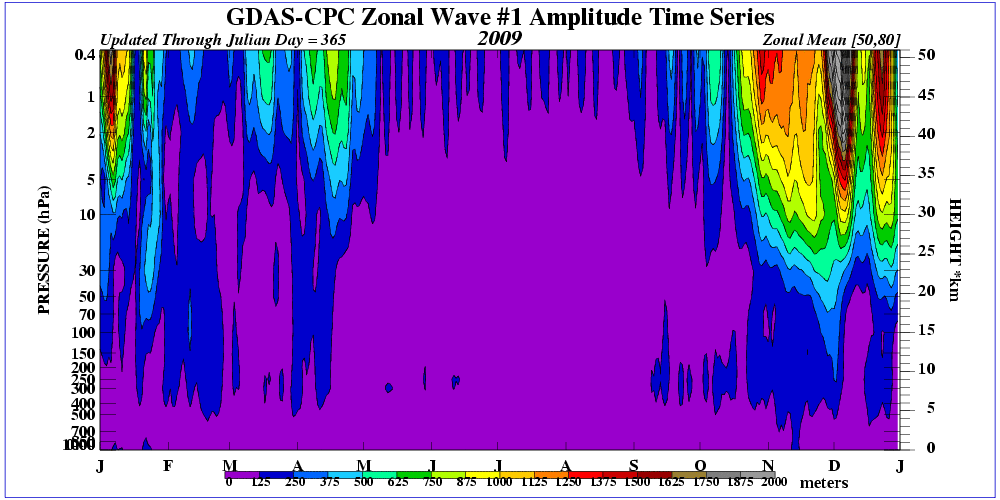
http://acdb-ext.gsfc.nasa.gov/Data_services/met/metdata/annual/z1n_50_2009.pdf showing significantly high Wave 1 flux (red) which, according to the Japanese, is unhelpful to propagation ( and note last January's much lower values in blue)
http://ds.data.jma.go.jp/tcc/tcc/products/clisys/STRAT/html_e/ep_12z_nh.html showing some healthy flux up into the Strat, but with very little of the poleward component associated with propagator type.
http://acdb-ext.gsfc.nasa.gov/Data_services/met/metdata/annual/u60n_150_2009.pdf showing (in blue) last years 'textbook' dramatic rise, then fall in high trop zonal winds either side of the key day (point of max warming @10 hPa). This year's red line does not show that pattern.
I'm afraid therefore that the current state of play does not really indicate that we're in for another whopping (splitter) SSW(MWW), nor do I think that any event that did occur would significantly affect the Trop. Sorry to report that, and i hope really that i may be proved wrong, but I think we may well have to look elsewhere this year for the cause of our next cold spell. Lack of SSW doesen't seem to have hindered us thus far
-
I would agree with that cc. Sometimes it is difficult to explain stratospheric processes in a clear and coherent manner. Keep your posts coming - you seem to have a clear idea of the synoptics - makes me think that you have been posting somewhere else previously!
Good post Brogdale. It is always difficult picking through these type of papers to get to the bare bones.
I am not as convinced as I was a couple of days ago that the current increased forecast wave 2 activity is going to lead to anything. Hopefully it will, but I am beginning to see signs in the forecasts that the stratospheric vortex is regrouping and regaining strength. Both the ECM and GFS suggest this with no significant warming on the horizon. However we still have a significantly cold tropical stratosphere which in theory should have an limiting effect on the strength of the vortex. In fact, when we look at the tropical stratosphere 30 hPa readings we see that the low temperatures are records for this time of year since the recordings began.
Looking from a stratospheric point of view at the possible breakdown of northern (Greenland) blocking I believe that we are still at least 10 days away judging by the GFS 100 hPa forecasts. At day 10 the vortex is reforming, but still showing signs of a declining Greenland high that may move westwards, with a Scandinavian trough and the UK in a probable northerly airflow.
The blocking forecast still looks good at this timeframe and supports this.
c
Hi Chionomaniac
I agree that any 'key day' is going to be some way off, but i do sense that we might be embarking on a 'growing stage' for another SSW.
Based on the paper I posted above, there are signs to indicate that any SSW that did develop over the next few weeks might well be a downward propagator.
This forecast:-
does appear to show the 'pre-conditioned' +ive zonal anomalies (50 - 80N) in the strat that preceed day -5 in a propagator
There also appears to be good indications of another pre-condition for propogation; negative zonal anomalies in the upper trop.Taken with the Wave 2 increases I thought it looks to be a situation of some hope?
-
leroys I have just noticed your question in the middle of my post.
I don't think you should get too concerned re whether we are going to get another 1947 or 1963 type winter. No one will know that for sure, but it has to be said that even though it is not impossible to get a 1947 or 1963 type winter, it is highly unlikely. We can only deal with what we know presently, and that is that we are now likely to see a period of northern blocking which substantially increases the likelihood of cold weather. In effect we are going to get a 2009/2010 event!
Regarding the warm wave that you mention, I assume that you are referring to the possibility of MMW/SSW. The possibility of a MMW occurring is certainly there and if a warming occurs then I feel that the chances of zonal wind reversal throughout the whole of the stratosphere would be quite high. The stratosphere repsonds to wave breaking caused by tropospheric events such as mountain torque events. There appears to be a large planetary wave number 2 event forecast for the next 10 days that can also be a precursor to a SSW - but there is no way of knowing for sure.
The stratosphere is currently cooling and the vortex strength appears to be increasing, as the vortex regroups, following the split.
The possibility of deep cold in the coming weeks shows what an important part that the stratosphere plays in tropospheric weather and I feel that this cannot be stressed enough. Without the weakened polar vortex during November, it is highly unlikely that the lower stratospheric and tropospheric polar vortex split would have occurred. One of the reasons that myself, Tamara, GP etc got so excited following the vortex split MMW last winter was because of the possibilities that can occur following this type of event. Alas, even though we may have had the best snowfalls in some areas for many a year, the true northern blocking that I had envisaged didn't materialise to affect us, for reasons previously explained. However it now appears that we have a 'bonus' event (whether or not we get long lasting deep cold or not) on our hands even without a SSW! Many of us stressed prior to this winter how important an easterly QBO would be and GP suggested how important the enhanced Brewer Dobson circulation would be, but I never thought that we would see an event this soon into winter. I know that we have not seen any snow yet, but the event for me is the vortex split - remember how important this is - it was stressed earlier in the thread.
And we still have the possibility of a SSW to come - I wonder was GP alluding to this in this morning's post when he hinted at mid Jan - it would certainly help.
c
Well after the exhausting business of model watching, its good to get back to the 'sanity' of the strat threads
I've really been trying to get my head around this piece from two Japanese researchers, that attempts to establish why some SSW events propagate downwards to affect the troposphere and others don't.
http://center.stelab...mazaki_koji.pdf
Now do forgive me if I make any glaring errors with this attempt at simplification, but here we go:-
Nakagawa & Yamazaki looked at 51 SSW events from 1957 to 2002 and defined 28 as downward propgating events (affecting the tropopause) and 23 as non-propagators. (They actually described them as Trop 'warm' and Trop 'cold' respectivly indicative of whether polar warm anomalies reached down below 500hPa).
They used the normal 'key day' definition of max rate warming ' 10 hPa, with -days before the key day and +ive days after.
So as we approach the point in the year when we might expect to witness the 'growing stage' of another SSW what signs should we be looking for if we are to get a downward propagator?
To start with both types appear to be characterised by preconditioned +ive anomaly winds above 10hPa, with the propagator type perhaps showing more intense +ive anomaly preconditioning till day -5. Both types also see a decrease in (50 - 80N) zonal winds @ the key day, and -ive zonal wind anomalies by day +5. But crucially it appears that the propagator type is determined in the growing phase (-10 to key day) with propagators having reduced zonal wind velocity in the high trop to the key day, and the non-propagators seeing high trop zonal velocities increase.
Also in this growing phase the propagators see Wave 2 > Wave 1 with EP flux exhibiting poleward propagation, whereas the non-propagators see Wave1 stronger and equatorward EP.
So there you have it (
) What we need to be looking out for if we hope to see a Splitting SSW capable of driving some cold our way later in the season is the following:-a) Increasing Wave 2 energy
:lol: Less strong wave 1 energy
c) Poleward EP flux
d) Decreasing zonal wind velocity in the high trop.
Shall we have a look?
a) & B) http://ds.data.jma.g..._12z_wn_nh.html
looks promising with the Wave 2 rising, and wave 1 declining.
c) http://ds.data.jma.g.../ep_12z_nh.html
looks like there's a healthy poleward element to the EP flux?
d) http://strat-www.met...cast=f192&var=u
some encouraging signs of decreasing/reversing high trop zonal winds there.
So all in all looking rather interesting for those of us keen to see another SSW this year, and hopefully one capable of producing effects way down into the trop for up to 40 days after the key day!
-
We still have great mean zonal wind forecasts which are now negative into the reliable timeframe.
http://strat-www.met...ecast=all&var=u
We have a lovely strat 100hPa profile at T+192 - the kind that I would have liked to see after last winters MMW- the only annoying thing is that the ECM forecasts are delayed a day so things may have changed by the time we look at them!
Looking further afield I am looking for evidence that the strong amplitude wave 1 may be ready to cause another warming. There are signs, with a severely distorted vortex shape at the 10hPa level that this could occur. Even though the mean zonal winds are forecast to increase dramatically I feel that the stratospheric vortex is there for the taking!
It's like a squeezed balloon ready to pop!
Hi Chionomanic
Shucks those report and assessment deadlines have really been stopping me from paying enough attention to matters straty. As ever, thanks for the updates. What's happening with those zonal wind forecasts? It looks as though there's very little reversal forecast up within the strat, but quite a lot down with us in the Trop...is that right?
So we've got those trop reversals without a preceeding SSW/MWW?
BTW have you seen the encouraging poleward burst of EP flux shown here:-
http://ds.data.jma.go.jp/tcc/tcc/products/clisys/STRAT/html_e/ep_12z_nh.html
now that is a good sign for your 'ripe' strat
-
My analogue winter to compare to is 1986/87.
More wave 1 before the displacement SSW. I expect (hope) this winters to be sooner than 23rd Jan though.
Well if its wave 1 you're after, have you seen the blocking forecast two weeks hence here:-
http://www.cpc.noaa.gov/products/precip/CWlink/blocking/real_time_nh/mrf3.nh.shtml
-
this is a very fascinating topic imho. it looks as if the upper stratosphere is cooling a little, and itll be interesting to see how far it cools. will it go below average? as a general rule of thumb, if it takes a few weeks for potential effects to propogate down to the uk from a ssw, then surely mid december would be a good place to look for a ssw event in time for january? brickfielders comments dont fill me with excitement exactly, but as we all know, these are forecasts for the stratosphere, and just like the models, they could easily change. surely a ssw will appear rather spontaneously as the name suggests. itll be interesting to see how stratospheric conditions played out during the leadup to the feb 1991 cold spell and jan 1987 cold spell.
Hi Azores 92
Do you know of this site?
http://www.appmath.columbia.edu/ssws/
if you use "View Events" on the blue toolbar you can then select a notable SSW event and explore many aspects of its features.
Unfortunately not many of the featured events tie in neatly with Cold Winter events that we have experienced in the UK, but the Dec 1981 event did preceed our 3rd coldest DJF CET since the war (2.6C).
I think Chiniomaniac will be interested in the wave flux component pattern that preceeded the SSW:-
Hmmm...lots of Wave 1 early on in the season.
If you then use the animations button you can view the event in 2 or 3D.
Enjoy.
-
Thanks, and I forgot to say welcome to Netweather! Any input from you will be very welcome.
c
Thanks
OK, I'll try a little input, but bear with me ....marking, reports and real ale are taking their toll of the old cognitive processes!
Here's the really interesting Japanese paper that got me thinking about propogation last winter:-
http://center.stelab...mazaki_koji.pdf
Now in their summary they appear to be suggesting that for propogating events we would need to be looking for Wave 2 flux? Do you think i've got that right? So how much notice should we take of the Wave 1 anaysis?
Back to the reports......
-
Hi Brogdale
I hope you are well.
I have posted on the other site but have real difficulty posting up charts and links for some reason.
I am sad enough to have already read the links and viewed the presentations from the latest middle Atmosphere convention. I noticed that you had homed into the same presentations that had caught my eye!
c
Latest update.
The start to this stratospheric winter has already been very interesting with episodes of record breaking warmth over the North Pole contrasting with very cold stratospheric conditions over the equatorial stratosphere. This has led to the very disturbed stratospheric vortex conditions that we are seeing presently.
There appears to be another episode of warming about to occur that I have mentioned previously:
This may have been caused by an increase in recent wavenumber 1 activity which I mentioned a few days ago. This has been extremely prominent during November and activity can be viewed here.
http://www.cpc.ncep....ALL_NH_2009.gif
It appears that another wave is in the process of propagating down the stratosphere.
However that is not what is grabbing my attention currently. What is grabbing my attention is a forecast split of the polar vortex from the base of the stratosphere/troposphere that is propagating upwards. It is this split vortex that is behind the interesting wave patterns that are being forecast by the tropospheric models. The last time we saw a split vortex like this was cough ahem back in January.
This split is being forecast by both the GFS and ECM but is more pronounced on the GFS and extends further up the stratosphere.
100 hPa level at T+240
30 hPa level at T+240
Could this just be?????
c
Hi Chionomanic
Thanks for the swift reply (and over on the other side).
You've given the TWO brethren a very clear, succinct account of the season so far and the inticing prospects. As yet not many over there appear very keen on Straty matters, but a bit of splitting in the offing should raise the level of engagement.
I have to say I'm very impressed with the thread you've got going here, and I'm in the process of working through the links, papers and graphics that have been posted already.
WRT to the Middle Atmosphere lectures I was certainly drawn to Newman's decadal cyclical analysis, but a bit disappointed with Long's consideration of the impact of the Jan event. I'd have liked a little more of the Japanese type research into propogation factors...but hey, I suppose you had to be there.
Anyway, its good to chat again, and keep up the good work...I'll certainly be a regular visitor this way from now on.
-
Many thanks for your reply. I had a read through the thread which does explain things. However, is a warmer stratosphere conducive to milder temps and a colder stratosphere to colder temps? This is the bit i can't get my head round.....
as for sudden warmings and mid winter warmings....WF
Hi Chionomaniac
Long time no speak!
Just thought I'd ask if you're going to come and have a chat on the 'other forum' 'bout this. I've already kicked a thread off and posted some links to a CPC conference site with illustrated talks from the pros! I think you might enjoy them if you haven't already found them.
Well waddaya make of this early upper warming? And the EP veering poleward?
Good to be back in straty business eh?


 ) What we need to be looking out for if we hope to see a Splitting SSW capable of driving some cold our way later in the season is the following:-


 as for sudden warmings and mid winter warmings....
Stratosphere Temperature Watch
in Spring Weather Discussion
Posted
Any links BA?