


Weatherwatcher
-
Posts
54 -
Joined
-
Last visited
Content Type
Forums
Blogs
Gallery
Events
Learn About Weather and Meteorology
Community guides
Posts posted by Weatherwatcher
-
-
A cell has just rolled past along the estuary producing regular pink lightning (2 or 3 rumbles a minute). Some stunning cloud structure. Another cell appearing from the west, looking very dark. This looks to be a little more inland..fingers crossed.
-
Yes a good sign that the temp is edging down at Manston in Kent as the flow there has turned towards the east. Lower dew points should be arriving soon.
Interesting that you say this Nick. Light snow currently falling, and not immediately melting, unlike a few hours ago.
-
Some snow now blowing around in the air. Very very marginal.
-
Hail now moving in

-
i wonder how heavy it will actually be this eve...is it gonna be really that bad?
I'm a little concerned about marginality for us coastal areas, but hopefully we'll see snow. Looks to be fairly light on the radar.
-
there is something not right about this event. i have a little feeling that its gonna be a bit of a let down. i could be and hope i am wrong
We've seen brief - and I mean two to five minute bursts of varying intensity - showers so far this morning. Waiting in anticipation for something more prolonged.
-
Glad to see there's some comvection firing Thanet way now. The streamers seem to be aligning more ENE. Could yet be some decent snow for far east Kent tonight. More interested in tomorrow though!
-
Some very light snow showers earlier this evening but nothing since. All the action seems to be 20-30 miles to my west.
-
Not a lot here really. Went to bed about 2am. Woke up at 6 with the sound of distant thunder. A handful of sheet flashes, one or two rumbles close by but mainly low distant rumbles of thunder every few minutes. Perhaps the low cloud didn't help. Very heavy rain when I woke up. This eased off to steady rain about 7am.
It looks like the system stayed out in the channel and lost most of its electrical form in the early hours. You lucky people on the south coast got quite a show!
-
So often they slip past through the channel, but we must be in for some activity tonight.
-
I'll be here when I wake up - probably around 7am
<{POST_SNAPBACK}>
I'd think it will be great viewing from then on, Pinball. I might have to set the alarm for about half 7 just so I don't miss the action.
-
24 hours ago I had the landfall here...
<{POST_SNAPBACK}>
Ok, IMO it's going to make landfall between Galveston and Port Arthur, probably nearer to Port Arthur. You don't seem to be far out. I said TX/LA border about 2 days ago but that was pure guesswork.
-
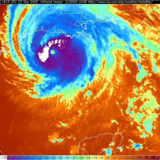
Excellent image weatherwatcher.
This sat image appears to update every 15mins. Been watching it for a while :unsure:
Remember UTC time is actually +1 hour!
<{POST_SNAPBACK}>
Nice 1 Mondy, I'll keep checking
-
http://photos1.blogger.com/blogger/3933/710/1600/r671.jpg
Infra-red image really shows up those cold cloud tops W and NW of centre.
-
http://img138.imageshack.us/my.php?image=152bn.jpg
Rita still has excellent outflow. Feeder bands are going strong, particularly that Cuban plume as pointed out above.
-
I agree, it is much more obvious now.
does this mean the storm is building in intensity again?
<{POST_SNAPBACK}>
Looks like she's countering the dry air but difficult to know if she's intensifying. Would think it will help her hold what she has though.
-
Impressively Rita's core does look to have stabilised in the last 2 hours. But this was never an ordinary 'cane. This thing did bottom out below 900mbs after all!
-
Some great (albeit brief) footage on Sky active of the eye from one of the Hurricane Hunters. Beautiful blue sky overhead, nearly stadium effect all around.
<{POST_SNAPBACK}>
I'm jealous I didn't see it
:unsure: -
In one parish in SE Louisiana there were warnings for 3 possible tornados. One tornado on the ground was travelling at 50mph. Not only do these people get told to get as low as possible to protect against these beasts, they also have to watch for flooding.
-
cat 2 at the most at landfall?
<{POST_SNAPBACK}>
Possibly low cat-3.
-
Recon can't find winds higher than 125mph even now, so NHC is being generous with 135mph. And Rita looks to be terminally ill.
-
Rita is choking on dry air now.
-
Some bus caring the elderly has just blown up in Texas according to FOX
Kain
<{POST_SNAPBACK}>
Heard there was a fire on a bus in Texas with elderly passengers on board. Think it was carrying evacuees. Heard also people are dying waiting in the traffic jams due to heat. Very hot in Texas today.
Just in - Fire is out, 1 confirmed death and multiple injuries.
-
Some are saying the ridge is moving out of the way now so we could see a clear turn north. Must say I'm not even going to bother second guessing Rita now.


El Gordo! - Spanish Plume Thunderstorm Discussion 4
in Storms & Severe Weather
Posted
I assume you're also from Thanet then Victor? In the past half hour skies to the south east have definitely darkened, with more convection shooting up also. Fingers crossed.