


Steve Caiels
-
Posts
68 -
Joined
-
Last visited
Content Type
Forums
Blogs
Gallery
Events
Learn About Weather and Meteorology
Community guides
Posts posted by Steve Caiels
-
-
33 minutes ago, Bring Back1962-63 said:
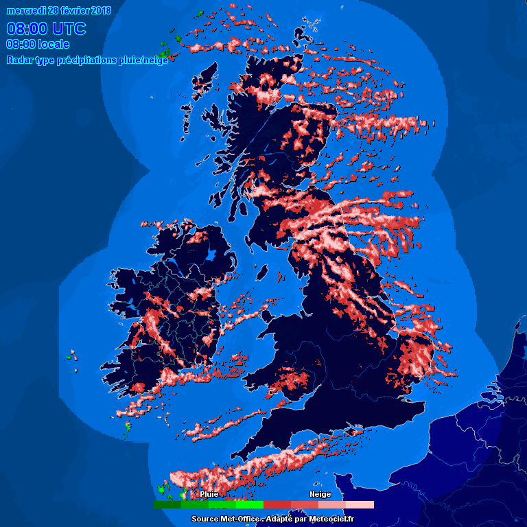
Very brief update: I may have been too conservative just now: My earlier predictions (from the last 2 days may have been right after all). Just look at the streamer lengthening again and strengthening during the last hour. The convective activity is still there and adding to it from the east-south-east. Loads of smaller shower echos showing east and south of the coasts up to Brighton. Today's snow may be more widespread after all as it all edges northwards. Just 4 quick charts:
0800 Live 0620 0920

I've got to do some work now but keep an eye on that radar - looking very interesting again. David
Yep. Getting real in Wembury now. Although the sky is lifting again as I type, there looks like there is plenty to come.
-
 1
1
-
-
We just caught the very northern edge of the Channel stuff. If this is what the edge can do in 20 minutes, imagine what it could be like if it *does* come inland!
-
2
-
-
I haven't caught up with the 6 overnight pages yet, but here is a quick update from South West Devon. As you will see on the radar, we JUST missed that significant snow in the channel. The remnants are blowing around, but nothing to add to last nights cover. The channel looks quiet now
An overnight low of -4.3, quite probably a fairly long term record I would think. Now -3.6 with a DP of -5.8. Home office was a chilly 12c first thing!
-
1
-
-
11 minutes ago, SNOW CRYSTAL said:
Fantastic Steve, great to see someone on the coast finally getting some snow. Nothing here at Yelverton ??
Thanks! We got some slush that froze and hung around for a few days in 2010. The last proper snow in Wembury was 1997 I think and that was very short lived.
-
1
-
-
I leave the PC for two hours and this happens!
First proper snow shower in Wembury. It came down pretty well for 30 minutes and dropped around 0.5cm I'd guess. Late to the party with the Easterly, but hopefully I'll be able to post early inroads from the channel tomorrow. I can't see that covering going anywhere soon! -1.6c, DP -4c
-
9
-
-
Looks like some lucky Irish folk have had a few rumbles of thunder snow?
-
1
-
-
1 hour ago, tomjwlx said:
what is everyone's dew points like?
0.9C 66% DP -5C
Conditions for Wembury, Devon at 14:23 on 27/02/18
85m ASL, 1 Mile from the coast and 5 miles SE of Plymouth
Sunrise/Sunset - 7:05/17:55
wx forecast - Increasing clouds and warmer. Precipitation possible within 12 to 24 hours Windy.
=====================================================================
Temperature : 3.1°C (Feels like 0.3°C)
Dewpoint : -5.4°C
Humidity : 54%
Pressure : 1019.7mb and Falling Rapidly over 3 hours
Today's Rain : 0.00in
Current Rain : 0.00in/hr
Solar Radiation: 262W/m² (UV index : 0.7)
10 Minute Average / Gust Wind Speed * Direction
5.0mph / 12.0mph * Dir=NE
=====================================================================
Daily values
------------
Temp between -3.2(°C) at 7:05 and 3.3(°C) at 12:38
Pressure between 1019.7mb at 14:14 and 1026.4mb at 0:00
Highest wind - 21.0 (mph) at 9:47
Heaviest Rain - 0.00in/hr at ----
Strongest Sunshine (UV) - 816W/m² at 12:38 (UV Index 1.4 at 12:18)-
1
-
-
Met Office have delayed the arrival of the low from the South West. Would you see that as an upgrade? Does it indicate that it is starting to stall as it reaches the cold air? I'm guessing the later it gets here, the more trouble it will have shifting the cold air?
-
So, we have the showers blowing in from the East; the convergence zone in the channel and the low pressure over Iberian peninsular. All potentially pushing into the South West
Could it be our time?
2c Air Temp, DP -6c. Overnight low was -3.2c. Bar far our coldest night of the year.
-
1
-
-
Finally started snowing just South East of Plymouth. There has been the odd crystal in the air since lunchtime, but I think it just about classes as snowing now. It's not exactly EPIC just yet, but if it keeps this up all night, there might just be a thin dusting by the morning.
-
3
-
-
Ian Fergusson still talking on twitter about the possibility of freezing rain post snow on Southern and South West coasts.
-
3 minutes ago, fromey said:
Weather warning cancelled for us down here on Wednesday they have put it further north!!!
But the "slight" one for Thursday is still there
-
Nothing here in SW Devon on the outskirts of Plymouth at the moment. Low of -0.5 overnight, rose to +2, but now falling again.
If power and communication line survive the ice storm, there should be live 60 second updates from two outside webcams on http://www.caiels.com/,
I think I potentially have front row seats for the "Beast vs Low"; "Rain vs Snow" battle. Yea - I know that's the wrong way around, but it rhymes!
Good luck everyone.
-
14 minutes ago, AWD said:
GFS 06z shows heavy snow overnight Thursday night for our region;
Before turning back to rain in southern coastal counties later in the day;
GFS 06z shows heavy snow overnight Thursday night for "some of" our region! Looking very marginal for SW Devon and even worse for Cornwall isn't it? With my very unknowledgeable eyes, just comparing charts and posts, I'm still holding out for Snow during Thursday, but turning to rain in the evening in costal SW Devon.
Although the Met Office weather forecast yesterday was pretty inspiring
-
Hello everyone. Another long time lurker here. Thanks for a great thread.
I literally went to the Drs today with dizzy spells. She thought it might be inner ear problems, but I reckon (hope) it's a premonition of what's to come.
Just for fun, here's an example of why we shouldn't trust snowfall apps.
Take a look at Tuesday. 95% vs 0%
For you 'Northerners' out there (that's anyone North or East of Dartmoor by the way), these are suburbs on the South Eastern edge of Plymouth.
It could be right of course; Plymstock is 1 mile to the West of Elburton. I know snow from the East is a rare event down here - but from what I am hearing . . . . this is a rare event down here!
I can't wait to get my first chance to record a timelapse whiteout in over 25 years.
-
3
-
-
@Philglossop. It's definately thunder now, with the odd flash of lightning. I'm just aroud the corner in Wembury
-
Hearing VERY distant thunder now on the south Devon coast, 2 miles SW of Plymouth. Not much activity at the moment.


.png.4916bd2cb8c808e85b5056c44bad342a.png)
.png.351b0c88a80b8085513be144fb2bdd1c.png)
.png.88b174a9032663e67e80de033d5dfa05.png)


South West and Central Southern England Regional Weather Discussion 22/02/2018 Onwards
in Regional
Posted
These showers just keep picking up moisture over Torbay, then intensifying over the South Hams Peninsular and dump it all on Wembury, Heybrook Bay and later down into the Lizard I guest
The snow seems a bit wetter. It has obscured the lens on one of the web cams. Air Temp -2.6c DP -3.6c
.