


Trom
-
Posts
226 -
Joined
-
Last visited
Content Type
Forums
Blogs
Gallery
Events
Learn About Weather and Meteorology
Community guides
Posts posted by Trom
-
-
3 hours ago, MATTWOLVES 3 said:
Yeh Mike if I recall my first taste of proper winter was as a 7 year old in the 81/82 big freeze..there was never really any talk of background drivers then like we discuss now. A weather presenter would simply say high pressure is building over scandy which in turn will be dragging very cold air in from siberia..and I recall some real bruiser of heights around the scandy region back then. Countryfile forecast is about all we had to go on.(granted it was good as they were all met office trained and gr8 presenters) but like you say there was no way of us talking up or down the situation on social media like these days..we simply waited for it to come off,where as these days we simply wait for it to go wrong.
Nearly 8 years old and waist deep in snow is when I got the buzz for it..I started drawing weather charts using an old atlas map,and putting all the symbols and isobars on...absolutely loved it...even run up a 200 phone bill as a 10 year old phoning around the UK for updates and weekly forecasts for different areas.. parents nearly killed me

And at long last we are seeing some sublime output and I kinda have that 80s feeling all over again. Sorry for going off on one mods I'm having a nostalgic feeling looking back on those days..
Let's reel this in folks...and thanks for the commentary...its a complete blast.
Probably quite difficult to do the computations for the NWP models on a slide rule back in the 80s Matt. My ZX81 with its 1K of memory would have struggled. Joking aside we've come a huge way in computing power, and the understanding of the teleconnections and their interrelationships is something that has really come on in my time on here.
Sorry mods - meant to post this on the moans and ramps thread please move or delete.
-
 1
1
-
-
1 hour ago, RainAllNight said:
Still wondering why the two runs would be different now they're the same resolution...
I would like the answer to that question.
I thought previously that the control had the same starting data, and the only difference with the operational run was the model resolution. Given they now have the same resolution but different results there has to be another variable at play.
-
 1
1
-
-
51 minutes ago, mushymanrob said:
THe NOAA Anomaly charts do not support the GFS's more progressive Azores high ridge/rescue Summer.... Although it might change... its not too far off
.

Mushy am I right in thinking that due to the averaging process in the anomaly charts (across models and time) it would take something to show up on one of the models for a more consistent time (i.e number of runs) before the anomalies would show it? Just checking my understanding.
-
1 hour ago, Bazza118 said:
definately chilly outside now and the moon is shining bright. temp has dropped down to -1.2c and dp is -2c. frost already forming on the wet grass so should be perfet base for when the snow arrives

It snowed today in South Croydon with temps of 4.6 and a dew point of 1.8. Didn't settle on very wet grass and surfaces.
Temp currently -1.4 with dew points of -1.8 so I recon you could be right
-
2
-
-
1 hour ago, CreweCold said:
Looks like a near perfect imprint of the first warming we saw to me?
Yes and this second stronger reversal is only just happening now. We know the models struggle with these events from past experiences and the extra levels of vertical resolution do not seem to have noticeably dampened the volatility between runs and models. The hope for me is the first warming puts us in a pattern like you posted and the recent downwelling compounds the easterly potential in the very long term. Could be a late start to Spring.
-
2
-
-
With the multiple reversals occurring I wondered if the NWP models would be able to quickly assimilate the impacts of a SWW. They have overall been hugely volatile in the past but I thought the extra verticle levels might reduce that confusion. 2018 remains a bit of an outlier in terms of how quickly the models built the likely impacts into their outcomes and that seems to have been largely due to the rapid speed of the reversal downwards. These events seem to be showing that the models still have a lot to learn. Not surprising I guess due to the lack of historical data available to backtest the algorithms and the fact that each event is rather unique. I'm assuming that the spread of outcomes between runs, in the ensembles, and between models makes the averaging process of the anomaly charts rather meaningless right now. I guess the best way is either to hunker down until a more consistent outcome is determined or focus on the teleconnections. Allround the final location of high pressure looks very undetermined.
-
2
-
1
-
-
1 hour ago, Uncertainty said:
I think you’re gonna be right Pete. We’ve said it all along. March is going to be mental.
I still think the big action is over 15 days away, and the murmurings in the eps will continue to be just that for a time. But from the last week in Feb onwards, it’s going to be Very, very interesting.
Tropical, solar, strat and now extended modelling support for a long await blocking spell.
7 days to the reversal and then 2 weeks to 2 months for the impact on the trop. So even with a quick response, we're looking at 21 days. I also remember the models having a lot of fluctuation/volatility when previous SSW events occurred. So I'm thinking at some point in March we will see the impacts.
-
24 minutes ago, Mike Poole said:
Yes, I agree, it is the one clear signal in amongst the noise from T240 onwards.
I am struggling to get a feel for the timescales over which I expect to see some results of the strat malarkey in the output for down here in the trop. There is both the flushing down of westerlies, followed by downwelling of easterly winds - potentially, but it is confounded by the warming seeming to occur in the strat in several stages leading to (most likely?) a gradual displacement (rather less of a sudden SSW, if the 60N zonal wind reversal does happen with that scenario), then there’s what happens if a split occurs - something more dramatic.
I think I’m sort of saying that I’m not sure the timing’s right for those charts you post to be a direct result of the strat warming, rather too quick, but I’m not sure. On the other hand, the other members that cap us off at a UK high may be seeing the flushing of westerlies.
Anyway, just musing - wonder what the pub run has in store?
I seem to remember from previous events that the impact on the trop was not initially well modelled by any of the models and led to periods of volatility in output before things settled down.
-
2
-
1
-
-
2 hours ago, LRD said:
Yeah, nicely put. Perhaps it's a good research subject for a budding meteorologist/climatologist (something I wished I had followed when I was young but Geography was a poor subject for me, based purely on the extremely dull elements of Geography that my school concentrated on. I didn't give a flying one about arable farming in the UK both in the present and down the years)
The inflated Azores High/Hadley Cell thing is definitely an issue across the globe, especially in places downstream of a massive ocean. I don't know much about Seattle's and Vancouver's winters of recent years but I bet they're plagued with mild, wet weather quite frequently in winter too. I recall the Vancouver Winter Olympics being held in remarkably mild conditions in Feb 2010
Seattle's weather is very similar to ours largely for the same reasons - being east of a large pool of water.
-
1
-
-
3 minutes ago, Met4Cast said:
I know the GFS is the hero at the moment and is showing what us cold lovers want, but it's worth noting that the model has been performing terribly of late often in third or fourth place.
I know there was that discussion on cannon fodder models, ie GEM but the GEM has been performing broadly better than the GFS. I'm really not buying it's persistently blocked signal. I think it's over-reacting to the MJO signal, it's too early & too aggressive with any blocking.
The EPS do show a colder period but seems to be more in favour of a toppler northerly vs Greenland blocking & prolonged cold.
It's roughly a correlation of 0.9 on that graph which can hardly be called terrible in the world of correlations. Again I would point out it is for the entire Northern Hemisphere and as we know the equator and polar areas typically have a much higher correlation than the mid latitudes. I tend to feel that these verification charts lead people to believe that the models are far better at forecasting for the UK than they really are. Remember we are mid lat and to the east of a big body of water. I don't think it's realistic to believe that the 0.9 correlation applies to the UK. I'm not trying to flatter the GFS but really pointing out that all models struggle with our location.
-
1
-
2
-
-
2 hours ago, Mucka said:
Synopsis for UK Christmas period weather.
I am using GFS 06z 168h through 192h as an example as it most clearly demonstrates how low pressure is likely to force the pattern over Christmas for the UK although obviously this is not set in stone.
After a milder and wet spell there will be return to colder conditions from the N, how far S this colder air gets is not yet known but it seems there will be N/S split somewhere over the UK
The first image numbers the main drivers of the pattern that will affect the UK over the Christmas period for the casual model watcher and attempts to explain what to look out for and what the consequences for UK weather will be.
The 2nd and 3rd show a 24h progression of the pattern to visualise the explanations. (Click on image to enlarge)
1.
The Arctic trough that will dominate our Weather patter leading into Christmas, the further S we can get this then the further S we should drag cold Arctic air and the more amplified the Atlantic pattern should become sharpening up any cold feed.
2.
Low Pressure systems moving W/E will merge with the Arctic trough somewhere over or just W of the UK bringing spells of wet weather from the S
The timing and tracks of these systems will dictate how much cold air the upper trough feeds over the UK, the less they develop and further S they track the further S cold air will likely get.
Where the boundary layer between mild Atlantic and cold arctic air masses meet will likely give snow even to low levels. At present this looks like being Scotland and perhaps N England though adjustments S or N are likely.
3.
Atlantic low and ridging toward Greenland.
So far it looks like a vigorous LP system will attempt to sweep in between Xmas and New Year and depending on angular momentum WAA and a ridge will be thrown up ahead of it.
The stronger and more N that ridge gets the longer any cold air over the UK will remain.
Currently it looks like any ridge will quickly be toppled and flatter more mobile pattern exist post Xmas but overall the output has been strengthening this feature.
If there were large enough changes in our favour then we could get the ridge to topple toward Scandi and get some undercut with a potential cold pattern later emerging.
If it were strong enough to resist and not be toppled then we would see the Atlantic undercut and continuation of any cold pattern post Christmas though this currently seems over optimstic.
4.
This possibly a developing feature through boxing day and into Christmas.
A secondary low splits off from the main low heading E possibly splitting energy SW/ E.
If this does become a feature then it can work for us or against us.
If it splits far enough W then it may head SE and become a cut off low and that will allow any northerly feed to continue longer as the rest of the energy pushes through into Scandi
It could also have consequences for the upsteam pattern depending on its behaviour or it could return NW and where and how it phased with the trough could have consequences for the UK weather, maybe widespread snow to rain event but total speculation at this stage and the feature may not even come about at all..
Lovely analysis.
Just using your arrows you can say you want 3 and 4 to prevent 2 to allow 1

-
1
-
-
No flip on the 18Z
-
1
-
-
35 minutes ago, nick sussex said:
This Arctic high seems to be causing all manner of model variability .
It could be partly due to the lack of observational data in that region . This was commented on as I remember by NCEP a while back .
I'd imagine this scenario being so rare means the models have not been back tested with similar data.
-
6
-
-
None of the models show any kind of pivot to the north (unlike Sunday's event). It seems to pass through the channel and fade south. Not that models are gospel of course but it would be a surprise if the SE was to catch anything other than very fleeting light snow showers at best.
-
9 minutes ago, Mark wheeler said:
Nothing for us tonight ( reverse psychology ) but no in reality the precipitation showing on the charts in the south west is giving minimal precipitation. Give up the ghost on that one I would suggest.
Agreed - if you get anything it will be a few flakes for a short time. Precipitation out West doesn't really look strong enough to reach the SE.
-
31 minutes ago, irish1 said:
Glasgow
A little worrying that Op and control follow each other so closely
-
1
-
-
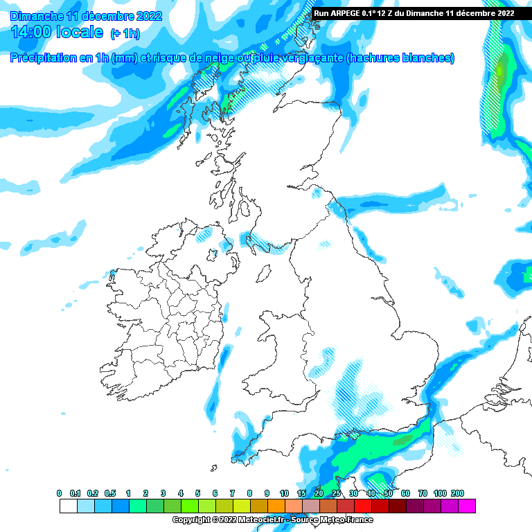
1 hour ago, Trom said:
This is what Arome has from its 12Z
and Argepege
So not programmed to hit us in the South East.
Precipitation on both models goes South
Having said that the radar has precipitation hitting Cardiff and the models had it missing a little South.
-
16 minutes ago, Mcconnor8 said:
Any current Arome/Arpege precipitation models for the South/South East tonight? The system moving over South West at the moment is more North and East than previously modelled so wondering if it will reach the South East later?
I posted the images for both 12Z models on the SE pages and it fades South into France.
-
 1
1
-
-
This is what Arome has from its 12Z
and Argepege
So not programmed to hit us in the South East.
Precipitation on both models goes South
-
1
-
-
-
-
Well from a South London point of view Arpege (rolling out now) gives more of a chance than the Arome model due to the pivot location.
Also backed by the Met forecast that's gone for more substantial snow showers with a higher probability.
Definitely one to be glued to the radar for in my locale.
Those to the East and Kent especially look good regardless
-
12 minutes ago, Bazza118 said:
first flakes starting to fall.
Good stuff can see the precipitation inching towards me in South Croydon. Weather station outside says -1.5 which is the warmest today.
-
15 minutes ago, MAF said:
To find the average of 19 and 20, divide the sum of quantities 39 by the total number of quantities 2:
=392
= 19.5
(19 + 20)2= 19.5
Hence,
19.5 is the average of 19 and 20.hope that helps :D
You get 78 if you forget the division sign!!
-
1
-
1
-


SE, London and East Anglia Weather Discussion - Dec 2023 on
in SE, London and East Anglia Weather Discussion
Posted
Out of interest, does anyone else seem to find that the Met constantly underpredicts the min low temp overnight? Last night -3 was predicted for my area (South Croydon) whilst the weather station in the garden said -5.4. Tonight it has +1 all evening but the weather station is reading -2.7. I don't notice this with daytime temps. Noticed it over the last couple of years too.