


Steve_Alltami
-
Posts
19 -
Joined
-
Last visited
Content Type
Forums
Blogs
Gallery
Events
Learn About Weather and Meteorology
Community guides
Posts posted by Steve_Alltami
-
-
6 minutes ago, snefnug said:
Just stopped snowing now, we had a beautiful bit of pivoting going on, all winter wonderland out there. Inspired enough to make a batch of pear mincemeat mince pies.

Think you might get round two as it starts to journey SSE later this afternoon.
-
 1
1
-
-
4 minutes ago, keithlucky said:
So the met mild wet weather sweeps across the UK next week.No it's not according to fax chart pressure now showing building from the NE let battle commence
Next Thursday looks interesting. A lot depends on how Wednesday's front behaves. In the 80s, it would be a classic slider followed by colder air...
-
1
-
-
Just now, SP1986 said:
Wow ! Certainly doesn't follow the radar
It's bizarre, I wasn't expecting it to be as persistent and heavy. We seem to be in a weird spot where the radar says something is falling from the sky, but nothing is. And vice certainly as per today, not much on the radar but keeps coming.
Meto looks nice too.
-
This was earlier for us. Still snowing and forecast looking promising until mid evening. Minus 2, so it's that nice fluffy stuff.
-
4
-
-
This was earlier today in Gwernaffield in NE Wales at 800ft. Still snowing here and the precip has stalled, so it's getting tasty.
-
2
-
-
Heavy snow here in Gwernaffield and nicely topping up the 12cms from yesterday. According to the radar, it was snowing for much longer than it actually has been. The returns on the radar are misleading. Perhaps the front of the precip is more a virga affair.
-
2
-
-
Somw really heavy snow in Gwernaffield NE Wales this morning. Couple of cms so far this morning.
-
8
-
-
- Popular Post
- Popular Post
This was us an hour ago in NE Wales at 240m. Still piling down now. All of the lakes of water on the roads are covered.
-
10
-
Heavy wet snow here to your southwest. In Gwernaffield, NE Wales at 800ft and heavy wet snow which is settling. You guys are in a great spot later.
-
4
-
-
Slightly confused with the meto update (for Wales) for this evening and overnight, with "Outbreaks of snow move into the north before dawn."... I thought the area of precip had been shunted much further west? Or is this referring to more organised showers?
Anyone with far more knowledge than I like to clarify? I'm around 5 miles from the border with Cheshire which is why I use the Northwest region chat rather than the Wales region which I find is biased to the South of Wales.
-
1
-
-
I live in N.E. Wales, close to the border at 200m ASL- so I hope you don't mind that I frequent this regional chat. I'm with you guys... a cold N'ly or NW'ly is my favourite, but can pull in higher DP's etc.
We've had a few snow showers this morning which have settled but are gently thawing with the temp at 1.2 degrees.
Today and overnight I'm mildly optimistic that I'll see more snow showers and hopefully something more substantial early morning. Like many here though - I'm worried about the marginality of it all.
Also wish I'd get more soft hail- love that stuff!!
-
5
-
-
26 minutes ago, Carl46Wrexham said:
It's......RAINING (again). Someone wake me when this (guffaw) cold spell is over.
We're just north of you and the snow on the ground is thawing and will be gone soon.
But - the light rain has turned to light sleet with the odd wet flake.
Latest BBC forecast also shows a lot more snow over north Wales, but altitude will help.
-
Could be some surprises... Here in NE Wales close to the Cheshire border we've had light rain which is now turning to sleet and wet snow.
Looks like evap cooling could also help.
-
3 minutes ago, *Sub*Zero* said:
Radar lies, I should be under light/mod ppn but zilch!
Same here - nothing falling from.the sky, yet according to the radar we should be seeking something.
-
27 minutes ago, lorenzo said:
Fantastic debate today, Stewart, Steve, Tamara - great to see such a meeting of minds here. So different in approach, so absolutely impassioned to see the weather people want and examine the evolution - hat's off to you all.
Love the fact that there are so many factors rolling around that can impact short term, medium term, mid range and long range.
[...]
To be fair, I've been a lurker for years - but I've loved the model watching over the last few weeks.
I've had 4 days with falling snow, two mornings with snow on the ground and not a clue about the conditions in 48 hours.
Good times - and here's to more :-).
-
2
-
-
2 minutes ago, Man With Beard said:
Much better cold clustering tonight. Probably more similar to ens output of 36 hours ago, with a strong cold cluster persisting until 22 January. To me that can only mean more support for the Atlantic going under the block completely.
To be honest - looking at the ECM clustering it's looking like it's one way or another. No middle ground - but things are improved over the last few days for longevity of cold.
-
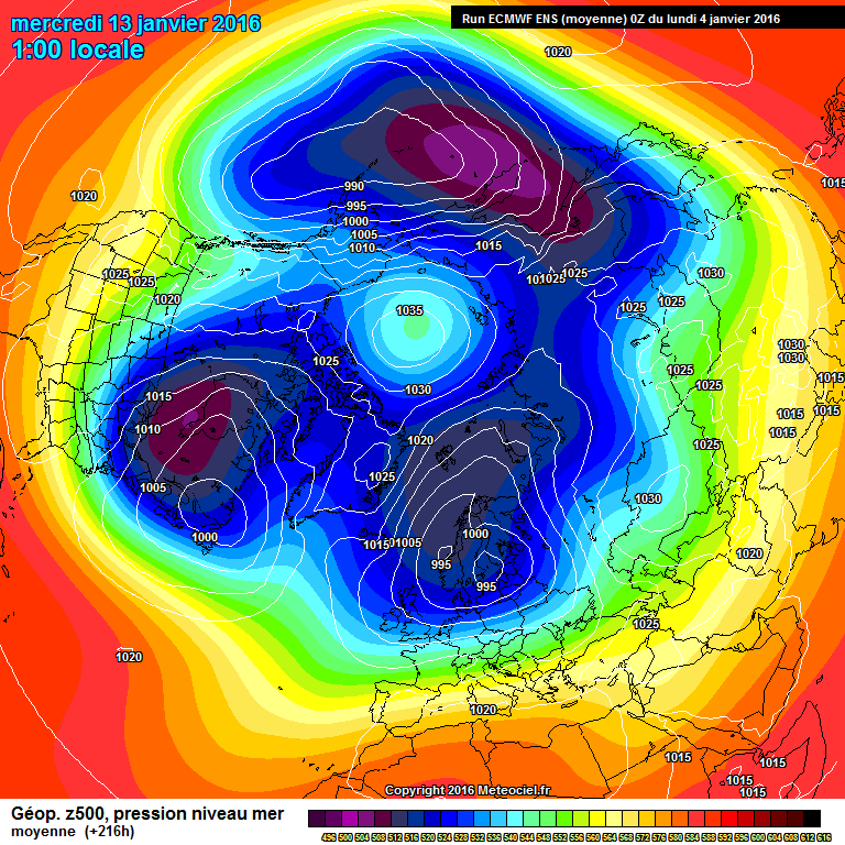
10 minutes ago, karlos1983 said:
Overall I'm still happy with the outlook, we don't quite get the Artic High link up with the Atlantic High, but so very close on the GFS(P).
Pretty happy with the ECM Ensemble at 216,
GFS op gets there as well really, but seems a bit to much energy coming out of N America pushing it east very quickly, which is not a massive surprise, it is the GFS, which does tend to favour a more mobile pattern historically.
I still remain very positive about mid month onwards.
Karl
I agree - things are looking so much more positive for later this month.
To be honest I didn't really expect much out of December and early January, but the whole NH pattern does seem to be evolving into something more favourable for our shores.
-
1
-
-
Brave move Steve and I hope you're correct. My gut instinct says we will be in a no-man's land between cold air to the north / north east and much milder air to the south / south West.
-
2
-


Wales/Cymru Regional Weather Discussion
in Wales / Cymru weather discussion
Posted
Another snowfall up here in Gwernaffield at 800ft. Around 5cms so far.