


Shuga ice
-
Posts
27 -
Joined
-
Last visited
Content Type
Forums
Blogs
Gallery
Events
Learn About Weather and Meteorology
Community guides
Posts posted by Shuga ice
-
-
Well it's coming! The milder weather that is. This chart is a good example of the slow erosion of the high from the north west. Unfortunately this is the wrong angle of approach for any snow to last. So currently it is looking like a mainly dry weekend with rain, sleet, snow approaching the northwest, then slowly sliding down the country with the southern half staying mainly dry for most of next week. Still some night frosts for the south whilst the north stays mild and damp. With the way the charts have been recently, the outlook could look entirely different on the next set of runs.

-
Unfortunately this is a downgrade by ukmo no matter how you want to paint it. I can see a slow sinking evolution here keeping the south mainly dry with the north and west turning milder and wetter in line with my forecast last week. There is hope that the high will reassert itself to bring in easterly winds which would give a proper cold spell rather than an imitation one.
-
10 minutes ago, *Sub*Zero* said:
Most of the UK has a covering of snow on the ECM, the only places that miss out appears to be the south west but some accumulations on the moors. 1 to 3'' for much of England, for N England northwards 4 to 8'' with more over hills and up to 24'' over the Highlands. Sub zero Ice days from Central England northwards but generally highs of 0 to 3c elsewhere, 3 to 6c in the south west.
If the ecm verified, the lowest temps and the deepest snow would be towards the south/southeast.
-
 1
1
-
-
13 minutes ago, sn0wman said:
Fantastic +192h chart from the ECM tonight! You could tell from all the WAA moving into Greenland at 168 hrs that this was going to happen. That shortwave moving SE would be a very good snow event for much of the country. Easterly incoming?
Certainly looks a lot more promising for us coldies today
That's what I was looking for, there is a good chance of an easterly developing. This chart has widespread snow, away from the northwest.
-
1
-
-
A slight upgrade on this mornings gfs. I am looking for further upgrades with the possibilities of a Scandi high establishing, drawing in easterlies. I expect this is the preferred option for most.
-
2
-
-
20 minutes ago, Paulmcc said:
Hello there,1st time replying here,Been a avid reader of these post,Looking at the graphs tells me nothing as im still learning,Are we looking at a cold week next week or a mild one like what we have had.?
It will turn colder next week but by no means a very cold or prolonged spell. I would call it a cool dry spell with wintry showers, mainly on coasts and hills.
it will be warming up again the following week.
-
1
-
-
This was how I saw it playing out yesterday. The overnight charts have moved away from the colder charts of a couple of days ago. We are looking at a cool dry interlude but with some transitional snow in favoured spots before rain spreads from the west. Met office aren't all that good either, they have to sit on the fence for as long as possible due to going public, but holding back does give the effect of them knowing better than others, simply not true.
-
4
-
-
6 minutes ago, johnholmes said:
Your post is not a true reflection on what any model is showing in the broad scale pattern of things.
Please pm me if you wish to discuss my post further.
John
I understand your point but I see the outputs playing with different scenarios. The outputs do look stunning but I really can't see the Atlantic playing ball to the extent shown. Remember, last week there was no sign of anything but mild, wet weather showing with a lot of despondency in here. I am just taking the middle ground view. It's pointless having a forum where you are only safe to post snow and cold possibilities and be berated when your view is the opposite.
tonights outputs may show a great outlook for cold but there is also a chance that they may start to get watered down.
I hope for cold snowy weather but it isn't in the bag yet!
-
3
-
-
No real change in the output from last night, a lot of dry and bright weather next week for 3 to 4 days before wet and windy weather with hill snow spreads to northern areas. The south holding on to dry weather a little longer.
-
1 hour ago, BM4PM said:
Sorry to put a imby type post up, but for myself its not looking that great. Current temp forcast for next week in my area is around 5 degrees.
The uppers are there but im guessing the sst must be still quite warm which inturn must be modifying the air.
I really dont understand as i dont think these charts could get any better.
They could get a lot better for your area, I am looking for an easterly feed which would be great for Plymouth. At the moment though I am only seeing a dry bright interlude for most of the U.K for 3 to 4 days before a return to wet & windy weather with hill snow in the north.
-
1 minute ago, i luv snow said:
Seriously? I really don't think that is what is being shown by most models..
Maybe to the untrained eye, but I have had years of following the models and you can't beat having the experience of witnessing the eventual outcome, northerlies bring mainly fine weather to the majority of the U.K. In winter. If there is a more continental flow, things will improve for cold and snow lovers so that's something to look for in future outputs.
-
1
-
-
The output observed today show a 3 day spell of mainly dry and bright weather, on the cold side with night frosts.
Temperatures gradually rising to above average thereafter.
-
1
-
-
Next week looks like turning mainly dry with plenty of sunshine around with night frost in places.
-
4 minutes ago, M1245 said:
Thanks but for a rookie not helpful at all.
I agree, that was not helpful. The colder weather looks like setting in during next week according to the latest charts, though I must stress that the excitement on this thread is because of the mild weather that we have had up to now. The charts are showing a rather cold spell as opposed to cold or very cold. This could upgrade to a colder solution if we end up with a continental feed. Northerly winds generally disappoint the majority on here if it is snow and longevity of a cold spell that is wanted.
-
4
-
-
6 minutes ago, Allseasons-si said:
Hi Shuga
taking this ecm run for a example,that would produce an easterly further down the line if the right conditions would prevail,plus there would be disturbances running down from the north
I agree with your thoughts and I believe many on here will be looking for a flow from the east on future runs.
-
1
-
-
1 minute ago, Nemesis said:
Not always - often we've had northerlies and cold air embedded with lows coming through the channel affecting a lot of the southern half of the country with snow. Right now any cold will do me so a northerly will be much better than the last 5/6 weeks
Like I said, there are a few exceptions, the winter of January 2010 had a low move down from the north which ended up in the channel giving the south a good dumping, but even then there was a continental feed. This is what I will be looking for on future runs.
-
2
-
-
Ecm looking ok near the end of the run but for a nationwide event an easterly component is required. Northerlies are only good for exposed coastal areas and hills, leaving much of the country dry & bright. There are a few exceptions of course but these are few and far between. Looking for upgrades from the east on future runs.
-
3
-
-
Happy new year everyone. See you all in November.
-
3
-
-
I wish people would understand that charts beyond 96 are complete guess work, a 5 year old with crayons could scribble more accurate charts. It is pointless hanging on every output.
Todays charts are showing anything from cold with a chance of snow to wet and windy. I look at the charts once every three days.
-
2
-
-
7 minutes ago, cheeky_monkey said:
why do people keep saying 1947 did not kick off until end of January ...when its complete nonsense.!..sorry for having to keep sayng this.
What they are trying to say is that the most noteworthy part of that winter started around 21st January 1947. There were other periods of cold prior to the 21st Jan but it was mild, around 11 deg c in a large part of the U.K. In the run up to the main event.
-
Too many posts claiming poor charts for cold lovers. Nothing has changed over the past few days, it's just the charts playing out different scenarios. One day the easterly is on then the next day the easterly is off. Which chart is correct? In my experience, easterlies pop up at short notice so the charts a few days ago showing easterlies in 10 days time could be correct. Time will tell.
-
4
-
-
One week of mild mush before turning very much colder from the east. There looks to be good snow opportunities for many parts of the UK. The met office need a bit more time before announcing this but based on the cold solutions that are building momentum, I expect colder weather in their forecasts by the end of the week.
-
I agree with Frosty, there is a big change coming, the Euro high departing is going to be the biggest change as this has been the main driver overall. Much more opportunities with its departure.
there will be plenty of eye candy in the next week. I wouldn't be surprised if we had a white new year at the very least!
-
3
-


 Certainly looks a lot more promising for us coldies today
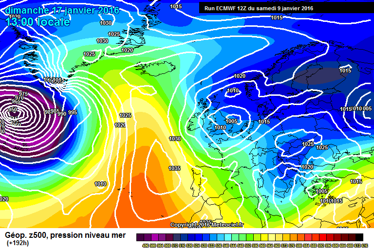


Model output discussion pm 13/01/2016
in Forecast Model Discussion
Posted
I would say there is more of a chance of an easterly next week now that bbc have made the announcement. The met office do tend to hold back on forecasts of predicting freeze ups and snow until they are confident. The graphics shown on the bbc were similar to some of today's output.