


Bob Lee
-
Posts
35 -
Joined
-
Last visited
Content Type
Forums
Blogs
Gallery
Events
Learn About Weather and Meteorology
Community guides
Posts posted by Bob Lee
-
-
4 minutes ago, Come rain snow or shine said:
That reminds me - where's Mr Blobby these days...
Runs a chip shop with Elvis
-
 1
1
-
-
4 minutes ago, snowrye said:
No one ramped it up,the system has moved northwards,sadly leaving alot of us in sussex and kent with next to nothing
I wasn't referring to anyone here at all it's a general term of phrase as we all know those sections in media those individuals who make weather forecasting a laughing stock. Here no one has told anything but truth in their hopes and subsequently disappointment or delight
-
It's not a non event it's just some individuals groups and sites have ramped it up so much those who love cold and snow have been given unrealistic expectations and were made so excited and now let down as here in reality truth dawns. Those who have their dream enjoy
-
4 minutes ago, snow freak said:
i thought the same here. i dont understand why the pavements are finding it hard to keep the snow cover when everything else is covered, only thing i can think is it retains the heat from the past few days more than everything else.
That's tarmac heat retention for you
-
All saying 4pm onwards as Metoffice says funny how you ignore part in text section where states as Northern counties cry off southern intensify. That fits what's happening out there lol
-
Herne Bay on North Kent coast is very windy blowing in mix sleety snow some settling on roofs grass not cars its at present wet snow not the powdery of recent
-
Just now, paget said:
I think we may need an apps anonymous group!!!
Definitely I have Metoffice app on my phone and obsessed by it lol
-
1 minute ago, paget said:
I know I shouldnt look at the apps but I can’t help it! I just keep getting drawn in!

I read people say don't trust them etc but I cannot help it either
-
11 minutes ago, yamkin said:
ALERT: A PROBABLE CONVERGENCE OF PPN TO FLOW FROM THE BELGIUM/FRANCE BORDER DURING SUNDAY AFTERNOON COVERING THE SE........EXCITING TIMES AHEAD
Where did you hear this?
-
5 minutes ago, Steve Murr said:
Mixed emotions from me today-
Heres the Summary:
Some people say its hard to forecast a streamer-
Its not- Its a peice of cake just using the 500 charts & the windflow barbs- hence 36-48 hours ago the upper air cold pool was modelled to hit us direct with boat loads of convective snow fall-
The difficult bit is actualy getting to the point where the modelling of said streamer actually lands!
So in the last 24 hours the 'hit' from the upper air cold pool & lowest uppers has moved up towards lincs-
That will put us in a slightly less favourable position for convection ( Sat into sun ) however what that does is throw higher uncertainty into the forecast because the models are still placing lots of PPN in the SE which are still associated with the upper low
However gone are the streamers - The favourable areas have perhaps moves away from North Kent / SE london - more towards West / East Sussex which is closer proximity to the low -
The 06z Hirlam does show the PPN clearing by Sunday morning-
However because we seem to squeeze another full day of cold sunday now ( IKON 06Z 66-78 then the threat of more snow showers moves back in-
So maybe not those original elevated todays we had first expected - moderated downwards to 2-10cm widespread- maybe a bit deeper in the more favourable spots
with 24 hours to go theres still 50 or so miles scope for change but not enough to move the upper cold pool directly overhead again...
Gone are streamers so Metoffice warning jumping the gun?
-
My understanding is Amber element is more to do with the ice it leaves in its wake?
-
-
2 minutes ago, markw2680 said:
This is exactly why it annoys the hell out of me, only the other day all the panic and doom about it all going to far south. Why do people panic when they all no the models will have wobble variances along the way before they correct nearer the time. It’s almost like certain people like to try and wind people up on here knowing that in reality the models will change again.
so when we get beast 3 let’s not panic when it all goes south a week or so before the event ?
It's way it is people pick charts that suit their personal preferences coldies go for those that show maximum amount snow Warm lovers for those that show Heatwaves. Like a sweet shop and forgetting upgrades and downgrades inevitable before the true picture emerges
-
Just now, Matty J said:
Avery has just done the 21:55 forcast and put barely any snow in the graphics at all. Mentioned wintry showers for Saturday and then put any heavier snow in the english channel for sunday!
Yet people in the mod thread are talking 20+ cms for some. His graphics had less snow on than the same time yesterday. Don't rate him personally and I'd rather listen to our experts on here, although personally i think 20+ cms is a bit of a tall order.
Yes quite there Is a lot of enthusiasm on that thread
-
Just now, Steve Murr said:
The shortwave arriving from the east blocked the easterly flow for about 12-18 hours last time...
Anyway - boomtown on the 18z at 66
It looks like a historic chart from the 1800's
NOT attacking by the way I admit readily to having a phobia about snow won't bore why so I am in a touch of a panic mode. Overall I want to educate myself about weather anyway
-
Everybody saying not as cold or as long lived but the snow amounts quoted here seem to be higher. Is that wishful thinking? Metoffice saying an inch some here going way above that
-
Confused as hell it's yes no yes on MOD thread. Bbc weather boo since Metoffice gone oh no hang on they say snow we like that Hooray Sheesh at this rate I will awake. All night Saturday into Sunday lamppost watching as lampposts won't bicker lol
-
2 minutes ago, Kent Blizzard said:
TBH from a selfish point of view, I've had my snow fix now, 4 days of snow potentially a 5th day tomorrow, road a nightmare, causes issues with work, its blooming freezing.......roll on the BBQs
I am eagerly awaiting The Daily Express headline "hottest summer for 38 billion years myself
-
1
-
-
I thought people said BBC Weather was pants now? Not having go honest but read its not so good after split with Metoffice yet when it's forecasting snow for us It's ooops forget that Yahoo we love BBC Weather Most confusing
-
1 minute ago, mpkio2 said:
You are indeed correct. I remember that day - 18th December 2010 - as a polar low brought heavy snowfall across London and the South East. I was watching BBC News all the while to get weather updates and around 11.30a.m, the Amber warning turned into a Red warning for Snow.
If I had some proof I would post it but I can't, for the life of me, find a thing online!
I remember it well too
-
2
-
-
2 minutes ago, phil nw. said:
A good question Bob.
Looking just at the gefs the further south the more noticeable any warm up will be but having said that next week doesn't look anything like Spring and further north over Scotland still close to freezing.
The ens 850's stay below zero nationwide for the next 7 days but the cyclonic pattern will contain less cold uppers as the current low will have mixed in some milder air from Biscay by early next week so we lose the really low 850's.
Having said that this complex low around the uk remains slow moving, cut off from the southerly tracking jet over Iberia.The winds will fall lighter and surface cold will tend to remain,although naturally without the Siberian feed daytime temperatures will lift somewhat affter the weekend.
The thing is though without the Atlantic jet heading this way really mild Atlantic air remains further south and is not driving north east over the uk which often happens with a full breakdown of an easterly cold spell when blocking finally gives way.
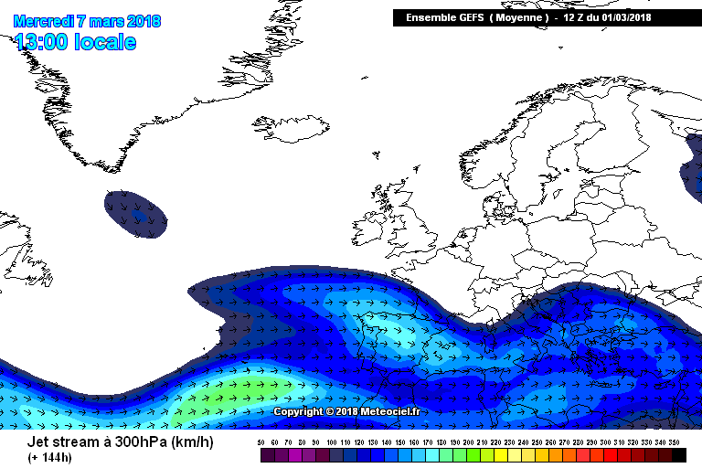
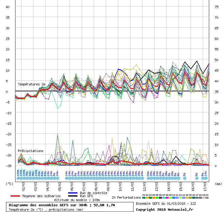
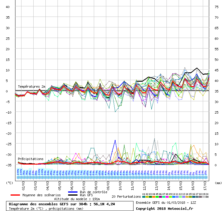
This is the day 7 GFS mean charts
and 2 graphs for 2mt temperatures one for C.England and one for C.Scotland
shows temperatures still struggling to get above freezing north of the border for sometime to come so those snowfields likely to linger for days to come.
That upper trough modeled over the UK next week still contains a lot of quite cold air so no doubt we haven't seen the last of any snowfall especially up there after this weekend,maybe even further south depending on any movement back south of sufficiently colder air- which remains a possibility in this setup.
ECM ens out soon let's see what they say.
Thank you for superbly delivered non Ramping answer. Laying my cards on table I hate snow and ice so hope we have seen the back of this severe spell anything less intense is manageable
-
7
-
-
1 hour ago, ICE COLD said:
Hope @Summer Sun is not looking at the ECM because here be having kittens again ?. Colder air coming back south ?
IT can be cold with sleet in May we all know that the short term shows it will get less cold than this period but a Heatwave is well off the menu... Famous last words lol... The question in this short term is how less cold will it get?
-
1
-
-
4 minutes ago, steveinsussex said:
Have the net office just updated the warning for tomorrow? I’m getting confused with how they all overlap! A bit more positive if they have
"chance a few cms" "still uncertain" not so much an upgrade as a Errrrm well we are as uncertain as everyone else
-
2 minutes ago, snowray said:
More heavy snow for the SE for Friday on the Hirlam 18z.
Covered by Nick Miller on BBC Weather for week ahead or does that discount it as I have read many here do that with them. Metoffice says different


SE and East Anglia general weather discussion 03/03/2018 onwards
in Regional
Posted
So much for at 1500 the SE Will get pasted. Light flakes here in North Kent if I learnt anything it's never trust anyone on line who promises they have all the answers. Want Spring now