


JCP
-
Posts
30 -
Joined
-
Last visited
Content Type
Forums
Blogs
Gallery
Events
Learn About Weather and Meteorology
Community guides
Posts posted by JCP
-
-
Sorry Ian, but that is simply not true and is very misleading.ECM ensembles strongly back the OP.
-
 9
9
-
-
GFS blows up the odd superstorm or three in FI so no luck this time.....well until the 18z when it can have another go with its RPG (random pressure generator).
-
1
-
-
Have you ever seen the build up to a Scandinavian High before? This is what often happens synoptically where the winds are mild southerlies for a time until they move gradually east of south.At this time of year, once any winds come from the continent, we'll start to cool down.Pretty dreadful outlook in the medium term with high pressure becoming banked over Europe steering up mild southerlies for most away from the far south-east of the UK. Outlook rather poor for cold searchers this evening. -- Main event in short term, with a significant wind event for Thursday with risk of widespread gusts to 70mph with some extreme gusts to 90mph possible in parts.
-
3
-
-
ECM full ensemble

Looks like a fair few members are trending milder as we move through the month
As to be expected every year as you move in to late February.
-
BB did you even realise you were quoting your own post? lol.
What is wrong with people today?!
I see Steve now has his own stalker too, lol!
-
What an earth is a displaced bartlett high? Am i being stupid here?
No, but the person who coined the phrase might be!
-
We can only comment on what is in front of us at this moment in time though Jordan. A persistent and stalled block to the east as is currently shown has as much potential to lock us in to a wet and windy spell of weather as a Bartlett high has as much potential to lock in and bring incessant SW'ly winds and a moist warm flow. As Nick and other people have pointed out, the chances of that high out east exerting more influence by extending back west looks very slim; so the best case scenario we're effectively left with is for it to clear off so we can at least have the potential for Greenland height rises.
Likewise, wishing for the high to 'clear off' won't make a blind bit of difference.
Also, we hear the wish for a 'reset' every winter and all we end up with is 3 weeks of westerlies.
-
Just highlighted the +120 GFS chart to keep your eyes out for the next runs.
This is the system that develops underneath the main low that begins the whole undercutting process that allows the block to our E to move W and bring the E,ly.
Spot on, that is precisely what is needed in order to back the winds and let the high gets it's foot back in the door!
-
All this moaning today yet we are still very much facing a cold to very cold setup get a grip people.
If people want to moan or rant about anything weather related it can be done here -
If you wish to discuss any potential snowfall this can be done here - http://forum.netweather.tv/forum/142-regional-discussions/
I am once again encouraged by the output today which get's us over that first hurdle of the sw tracking and sunk se by 90 hours which is now in the reliable and has shown no signs of taking a different route over the past few days so i can now 99% say that that is nailed on and penned in.
Beyond this is were we can potentially have a very cold setup & possibly snowy. All these details will not be confirmed until at least 48 hours time which is why there is no point in hanging on each run beyond reliability as it will change as the models firms up on what type of easterly we will see & as for experienced members stating ' Dry Run ' ect i think ' Come on how long have you been watching the models for? As you know as well as i that snowfall is unpredictable especially in a easterly flow as connectivity can often come into play'.
For those newbies out there and for those who are seeking answers regarding snowfall there is a learning facility available on n-w which is a brilliant learning tool to use & to gain knowledge.
But for the general rule of thumb you cannot tell no more than 24 hours out in this potential spell where we may well see connectivity from the east coasts then you cannot tell until it happens.
Hope that helps.
L-S
Do you have to use that font? I find it really hard to read, so just end up skipping the whole post, which is a bit of a shame.
-
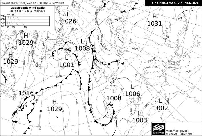
A word of caution among the excitement, the UKMO (which let's face it, NEVER wants to give us a nice chart at + 144) doesn't look all that good to me.... it could be a lot worse and It does have potential, but if that Low Pressure system retrogrades NW instead of W , we would end up being back in cold zonality before an Easterly ever gets the chance to even get going
UKMO + 144
That's the GEM though ?
-
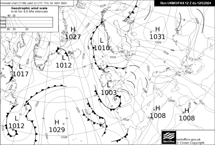
He is right, there will be no cold spell later on if that 12z UKMO comes off, its NOT good at all...
How do you know?
I can easily see how that could progress to a cold evolution within two days.
-
GM -Global Model
WBFL - Wet bulb freezing level
EC - short for ECMWF model.
-
not this AGAIN IS THIS TODAYS FAX OR YESTERDAYS.
Try this then
(the ? String at the end of the link will ensure the latest chart is refreshed)
-
Winters on its way guys :-)
-
Up to 102hrs on the ensembles and there's some promising runs in there - is the pendulum swinging back again?!
-
Control + F5?
Unfortunately not, I'm on an iPad ;-)
Got it working in the end, thanks to the direct link http://www.meteociel.fr/ukmo/fax/fax96s.gif
sorry all!
-
Today is Monday.
24 hrs is Tuesday.
48 hrs is Wednesday.
72 hrs is Thursday.
96 hrs is Friday.
I don't quite understand??
Must be something wrong at my end - I can't seem to get it to refresh to tonight's?
-
Hmm it shows 29th for me, even after many refreshes!
-
Ok, seen the Fax, can go to bed happy(ish) now, what awaits tomorrow, god only knows!!!
I repeat, to tonight's fax hasn't updated at the time of writing...
96hrs = 4 days = Friday.
-
That is yesterday's fax.
-
@Isolated Frost -- I don't understand your point about the 72hr fax and the Norwegian short wave?
It is also on the 72hr UKMO run tonight, and pretty much gets 'smoothed out' by 96hrs.
-
MattHugo on twitter highlighting that he expects the 96 and 120 to be modified from the UKMO after discussion- probably negatively
I bet he's wrong. Why would they modify it, when they didn't last night?
If anything the UKMO has more support for the 96/120 time period than it did last night.
I don't understand the obsession with his tweets tbh.
-
At 126hr the chart is ludicrous and appears to be a weak northerly spreading from Lapland to the equator !
-
It's amazing how often in this situation we get a shortwave on the Norwegian west coast holding up the really cold air.
Anyone know what causes this?


Model Output Discussion 1st January 2014-06z onwards.
in Forecast Model Discussion
Posted