


Aleman
-
Posts
770 -
Joined
-
Last visited
Content Type
Forums
Blogs
Gallery
Events
Learn About Weather and Meteorology
Community guides
Posts posted by Aleman
-
-
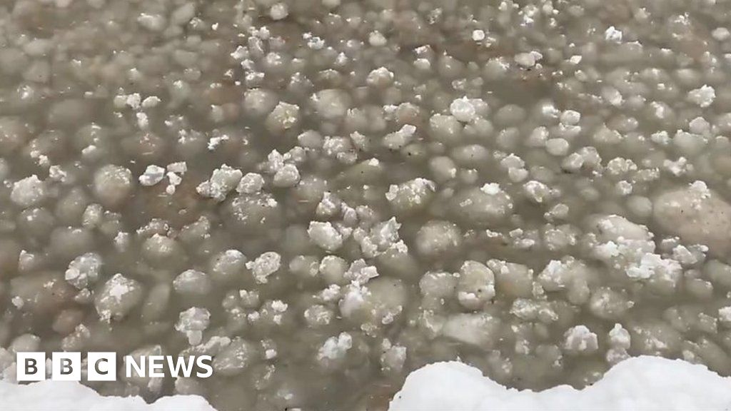
Talking of Lake Erie last week:
 Large ice balls wash ashore at Lake Erie
WWW.BBC.CO.UK
Large ice balls wash ashore at Lake Erie
WWW.BBC.CO.UK
The phenomenon was seen in Ontario, which has been hit with freezing temperatures this winter season. -
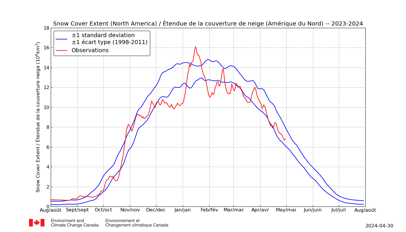
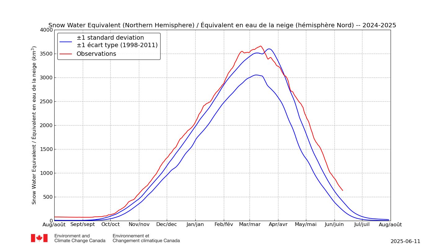
North American snow only looks to be slightly below average, after several quite high years, making it feel like it is much lower than it should be when it's actually not far off. However, adding to that, the low anomaly periods have been during what are usually the colder months. Without big snowfields to drop temperatures sharply during the longest nights, presumably that means the marginal ice areas in the Great Lakes see less or no ice formed. (Did they go into autumn with higher temperatures this year?)
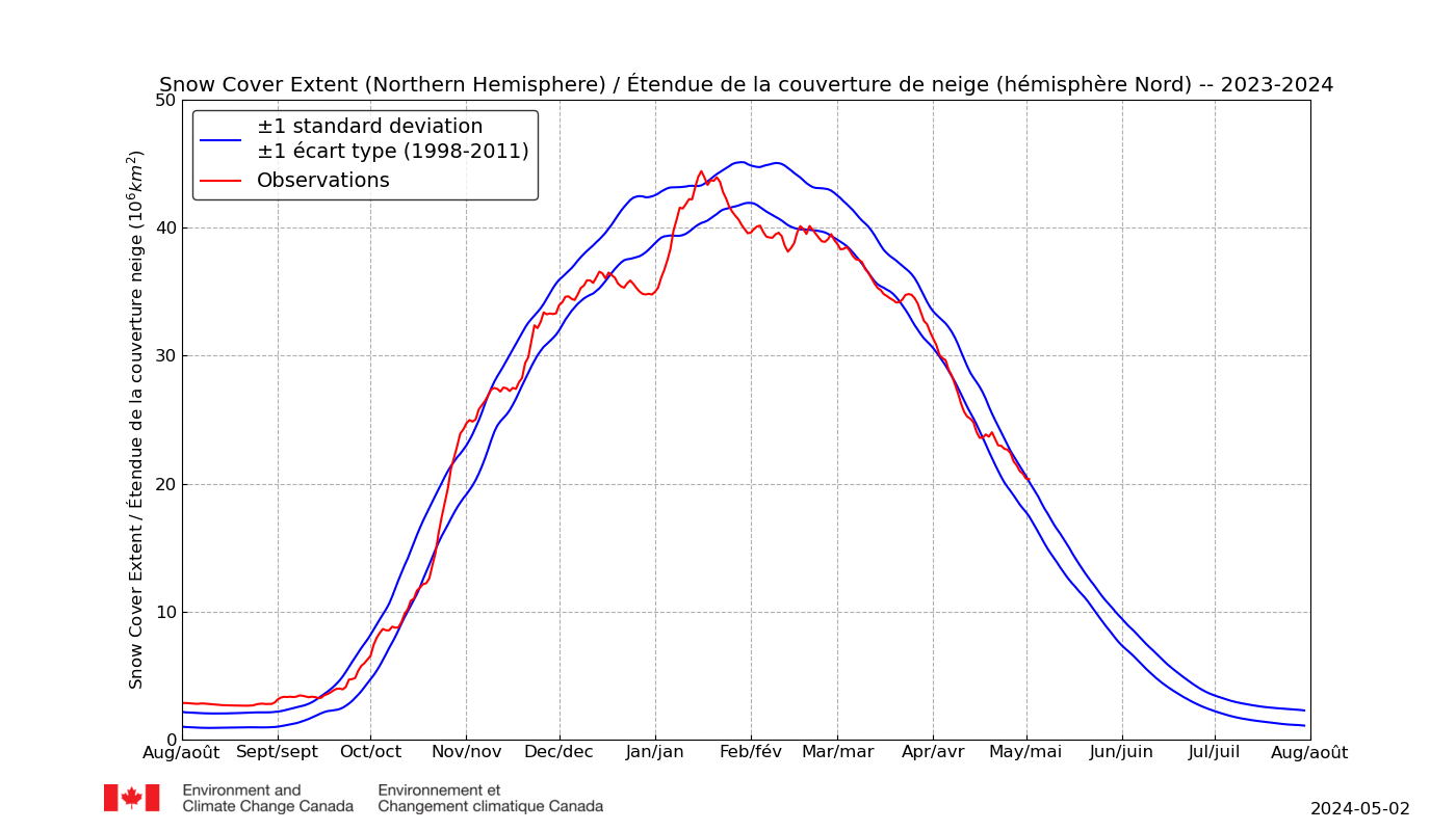
The Northern Hemisphere is not far from average.
-
 4
4
-
-
Altnaharra hit a new low for this winter for itself and the main Met Office stations of -13.8C.
-
 1
1
-
-
Lower snow looks to be mostly down to North American swings. Take that out and the rest is, and has been, pretty average.
-
1
-
-
I noted Is-Y-Coed with -8.5C on December 1st so I think you'll find the lowest for Wales has been very recent.
-
1
-
-
-
Yorkshire hills got snow for those that missed it. There was not much but there were slight signs if drifting in the wind. The roads cleared today but you can see on these live feeds where wind has blown a modest amount back onto the roads. The road from Pickering to Whitby was closed for a while yesterday..
North York Moors
Dales
-
1
-
-
We were not sure which ones counted in Scotland. Of the regular suspects, Altnaharra had -12.6C but there were a couple of less familiar stations hit -15.0C if you look back on this thread. In England it was -9.4C at Shap. That is currently -6.8C so beating its own low looks very possible. Whilst many moan about the lack of snow in the current cold snap on their own doorstep, there is plenty on northern hills that seems to be driving down temperatures such that new lows for winter look probable tonight.
Edit - whoops! I missed Shap's -10.5C this morning
And some might find Lerwick's -7.0C of interest.
-
I'd expect a new low for England give the way it it plummeting here in the Vale of York. I've gone from a 2.6C high to the current -3.3C in around 3 hours. Anything like that in the usual cold spots should see new lows.
-
1
-
-
Looking dodgy on hills with even more coming in soon and temperatures starting to drop again:
North York Moors (A169 Pickering to Whitby has been closed)
Dales
-
4
-
-
Not quite there last night - a few degrees off in Scotland but Benson only 1.1C off England's and Shap's previous -9.4C. It's snowing in Northwest England which will help drop temperatures tonight, where cloud clears.
Minimum Temperature Last 24h
01/16/2024 at 08:00 UTCNo.LocationStation IDAmount
1Tulloch Bridge (United Kingdom)03047 -10.5°C
2Aonach Mor (United Kingdom)03041 -10.4°C
3Cairnwell (United Kingdom)03072-9.1°C
4Benson (United Kingdom)03658 -8.3°C
5Bournemouth Airport (United Kingdom)03862 -7.8°C
6Aboyne (United Kingdom)03080 -7.5°C
7Charlwood (United Kingdom)03769 -7.4°C
8Loch Glascarnoch (United Kingdom)03031 -7.3°C
9Exeter Airport No2 (United Kingdom)03844 -7.2°C
10Spadeadam (United Kingdom)03224 -7.1°C
11Bealach Na Ba No2 (United Kingdom)03039 -6.8°C
12Warcop Range (United Kingdom)03226 -6.8°C
13Shap (United Kingdom)03225 -6.5°C
14Larkhill (United Kingdom)03743 -6.4°C
15Northolt (United Kingdom)03672 -6.3°C
-
It was -10.0C at Tulloch Bridge this morning. With more widepread snow and lighter winds,there is a good chance of lower tonight somewhere in Scotland. Northern England is already 3-4C colder tonight though has a bit more to do to get to a new English low.
-
13 hours ago, Midlands Ice Age said:
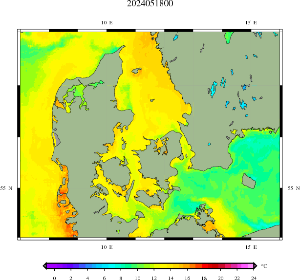
***** SEA ICE IN THE NORTH SEA ******
Thought it worth a post to back up what Aleman and I were discussing above.
Believe it or not it looks as if it has just happened in the North Sea, !!!!!!!!!!
Was looking at the spread of the sea ice in the Baltic (graph below) whilst I checked the Masie Sea ice map for the Baltic (screenshot below)
If you zoom in on the screenshot you can see a lot of 'sea ice' off the west coast of Denmark. (Part of the North Sea)
Now I know it has been cold over there but not yet cold enough for sea ice to widely form.
They have had a lot of snow however.... I think it must be this which has laid down a layer of slush on the sea surface and which has now frozen over.
Also apparent should be a small patch of, I think, natural sea ice off the east coast of Southern Norway,, at the end of the newly laid down sea ice along the Baltic coasts of South Sweden.
These situations I have not witnessed before this century. 2010 was the last major freeze in the Baltic. I do not recall this happened even then.
Happy times...
MIA
Looks about right. We've seen sea turn slushy down the English East Coast in a cold snap I forget exactly when, so Ice on shallow waters of western Denmark could be expected given how cold and snowy it has been there. DMi picks up the sub-zero sea temperature in places. Other sources shows pockets of frozen sea in the islands of the Danish straight and up near Gothenberg.
-
3
-
-
Forecasts suggest a similar winter storm is coming to Texas next Monday/Tuesday that might make it a touch further south. (I have family there that keep a few farm animals and tip them off sometimes.)
-
1
-
1
-
 1
1
-
-
Not so far off new lows last night. Maybe an outside chance of a new one if somewhere snowy avoids cloud all night
Minimum Temperature Last 24h
01/09/2024 at 16:00 UTCNo.LocationStation IDAmount
1Aviemore (United Kingdom)03063 -11.1°C
2Altnaharra (United Kingdom)03044 -10.2°C
3Cairnwell (United Kingdom)03072 -8.4°C
4Cairngorm (United Kingdom)03065 -8.2°C
5Lossiemouth (United Kingdom)03068 -8.1°C
6Loch Glascarnoch (United Kingdom)03031 -8°C
7Kinloss (United Kingdom)03066 -6.5°C
8Aonach Mor (United Kingdom)03041 -6.4°C
9Tulloch Bridge (United Kingdom)03047 -5.7°C
10Aberdeen / Dyce (United Kingdom)03091 -3.7°C
11Tain Range (United Kingdom)03062 -3.7°C
12Aboyne (United Kingdom)03080 -3.6°C
13Castlederg (United Kingdom)03904 -3.3°C
14Bealach Na Ba No2 (United Kingdom)03039 -3.2°C
15Aultbea (United Kingdom)03034 -3°C
Script courtesy of Michael Holden of Relay Weather. Data courtesy of Ogimet
-
1
-
-
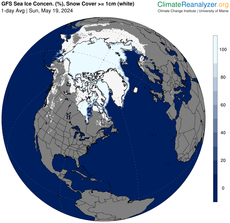
I've seen Icelandic sea ice a few times in recent years (to the West/NW). Maybe there is a small shallow there and/or heavy snow has dropped on colder water on that side. It's an unusual connection to Greenland I'm wondering about.
With regard to sea ice forming, sea new ice off Newfoundland after recent snow. There is occasionally isolated ice patches recorded in this cold sea area after heavy snow. I think I posted similar last year.
-
1
-
-
By the way, I know Kippax. I used to live in Garforth with a tiny walled garden of chippings with a conservatory and deliberately very dark-painted decking. When it was sunny on a calm February day, you could sit out for half an hour with a coffee and sandwich, even with frost everywhere outside the garden not melting. It blocked out the wind and often read 5C+ warmer there than whatever local stations said there at that time of year. Trouble was it could be too hot to walk on in summer - but then you'd go to the Gaping Goose and sit on the decking when you got home!
-
14 minutes ago, Harsh Climate said:
And this point ''A class 1 WMO weather station requires 100m free of windbreaks and significant structures like fences'' these weather stations are designed for people's back gardens, how many people who have purchased a Youshiko or similar weather station have a garden with at least 100m length or width?

I was just pointing out that it might be futile trying to calibrate against another station due to the very localised nature of temperature
(in built-up areas), which many people do not appreciate. -
LOL. I honestly thought it was someone else! I hope the links, etc highlight the fact that I'm being sincere.
-
34 minutes ago, Harsh Climate said:
I don't mean this in a bad way mate but I want whatever your smoking!
If your outside weather sensor is protected from the elements like sunlight/ rain in say a designed weather sensor box like the one I've got
You certainly aren't going to get a difference of 3c whether or not it is placed near a hedge or a fence!
. I think your on the troll aren't ya.
I assure you it can. I have a terrace with south facing patio windows that reflect sunlight onto it. We never get frost within a couple of feet of the house even down to -6 or -7C. If I mounted a weather station on the house wall there it could be 5C or more higher than the bottom of the garden on a windless sunny winter day that does not average temperatures out. In summer, the bottom of the garden is cooler due to shading and transpiration from numerous trees, shrubs and grass. Temperatures can pool between or hedges when there is no wind. On a grey windy day, it's probably less than 1C but the house still radiates, especially through windows. Such variations seem widely underappreciated but more can be learned about weath er station siting if you research. Getting the best representation of what you want is up to you though. Do you want to tell people what the temperature is in the cool bit of your garden or on the hottest bit of your sunbathing terrace?
I take it you do not have a large garden but a small garden could still probably manage 1-2C difference when not windy, much less if windy and no sun. My own garden is large. On a windy winter's day, it is similar to local MetO stations. On a calm summer day in June, it tends to be 2-3C warmer - and that is over grass nowhere near the terrace that would possibly add on another 2-3C. It really van make a huge difference AT CERTAIN TIMES of low to no wind. When it's windy, it could be considerably less than 1C, though.
I'm, not trolling at all. A class 1 WMO weather station requires 100m free of windbreaks and significant structures like fences, building, roads and paths because studies have shown they are considered to have effect up to that distance. Here's some reading. Knock yourself out.
Weather Station Siting: How to locate your weather station
WWW.CAMPBELLSCI.EUNumerous linnks to references at the bottom of this:
Siting Classification | World Meteorological Organization
COMMUNITY.WMO.INT -
2 hours ago, Harsh Climate said:
Anyone in Garforth give me a temperature reading from their weather station, just set mine up and want a comparison.
Is Bazookabob about?
Met Office WOW -
WOW.METOFFICE.GOV.UK
The UK Met Office Weather Observation Website (WOW). WOW allows anyone to submit their own weather data, anywhere in the world.Temperatures from nearby are often not comparable unless it is very windy. A northern and southern aspect could differ by 2 or 3C for instance in calmer weather. Central of a small town could be 1 or 2C higher than just outside it. (I've seen London up to 6C on a still winter day). A shaded "cold pool" can be a few degrees colder than nearby. I could probably get 3C difference in my own garden with hedges, tree overhangs, wall reradiation and window reflections. Siting a weather station is notoriously difficult for it to be representative of the area. Your main aim is to get it representative of your garden! Temperatures can be locally different within metres - either side of a fence or hedge, central garden or corner out of breeze. Make sure your weather station is as open to weather as possible - usually the middle of the garden - but avoid sunlight and reflections. Nowhere in your garden quite does all that - join the majority!
I'm not sure about shading. Traditional probes had to be in Stephenson screens to block out sun and windchill effects of settling rain - in order to make for as much consistency as could be had from place to place. I've no idea how modern varying plastic-housed stations account for this. Maybe they don't. Anyone?
It's been suggested the best way is to run the station and check it by putting a tiny sample of water as near as possible in a small white container at the same height and see if it starts to freeze at 0C on your thermometer. That's probably a much better idea than trying a comparison with another site that could be a few degrees different even though technically accurate.
-
I'd guess the most likely reason is the solar cycle. We are at the end of a downswing. The cooler half of the cycle was 2016-2022 but energy comes in at the equator and takes a year or two to be absorbed by the sea and move out to poles. A solar upswing has just started in early 2023 so I'd guess maybe one more cold winter in 2025 and then we'll see mild, windy winters in Europe again. There are loads of other factors at play, though, so don't expect to see a clear trend. There has been a pattern going back centuries but it sometimes seems to go missing for the odd decade.
-
1
-
-
2 hours ago, Harsh Climate said:
Just bought a new weather station.
An hour in from setting it up, it's showing 5.7C and barely falling anymore when local obs are showing 4C. Am I being too impatient in setting it up?
The sensor is in one of those weather sensor cases. It's a Youshiko.
It's badly sited. A WMO Class 1 weather station is supposed to be 100m away from significant windbreaks but yours is next to a fence that blocks the weather out and prevents you getting a realistic measurement of local conditions. You are just measuring a very very local microclimate of in a very sheltered corner of your own garden. It's very difficult to get readings that represent your locality if there are all sorts of interfering structures nearby but the best place is usually in the middle of your lawn but out of the sun. It's actually quite hard to get an undistorted reading in an urban garden (e.g. sunlight reflection off windows!) but it's still very interesting and useful so long as you undertand the weaknesses of your station and its location. Read up on it a bit, find a better location and good luck with enjoying its future output.
-
2 hours ago, Alderc 2.0 said:
Bit embarrassing really imo. Very little indication of severe cold.
Not embarrassing at all. Firstly there have been some pockets of lingering cold in the west of the UK this morning in a number of populated areas where it did not get above 0C until lunchtime, so it has been quite cold and forecasts suggest more widespread cold with the addition of wind on Monday and Tuesday. Secondly, these are health service warnings and not general weather warnings about disrupted travel. People sometimes confuse the two. Winter bugs are only at moderate levels at the moment but have picked up alittle ahead of Christmas and flu has been on a sharp rise for the last few weeks and often rises more quickly when we hit colder than average weather. These warnings are for health services and certain other caring professions that might see surging workloads. As hospitals are already fairly busy they need to be prepared for a possible surge in flu victims, and similar, who might be in need of urgent treatment. They will now be making contingencies for postponing less urgent treatments and carefully monitoring the cold weather outlook with the help of these health alerts.
-
1
-


Snow and Ice Northern Hemisphere - Winter 23 /24
in Spring Weather Discussion
Posted
I missed the ice bridge from Greenland to Iceland earlier this month: