


Aleman
-
Posts
770 -
Joined
-
Last visited
Content Type
Forums
Blogs
Gallery
Events
Learn About Weather and Meteorology
Community guides
Posts posted by Aleman
-
-
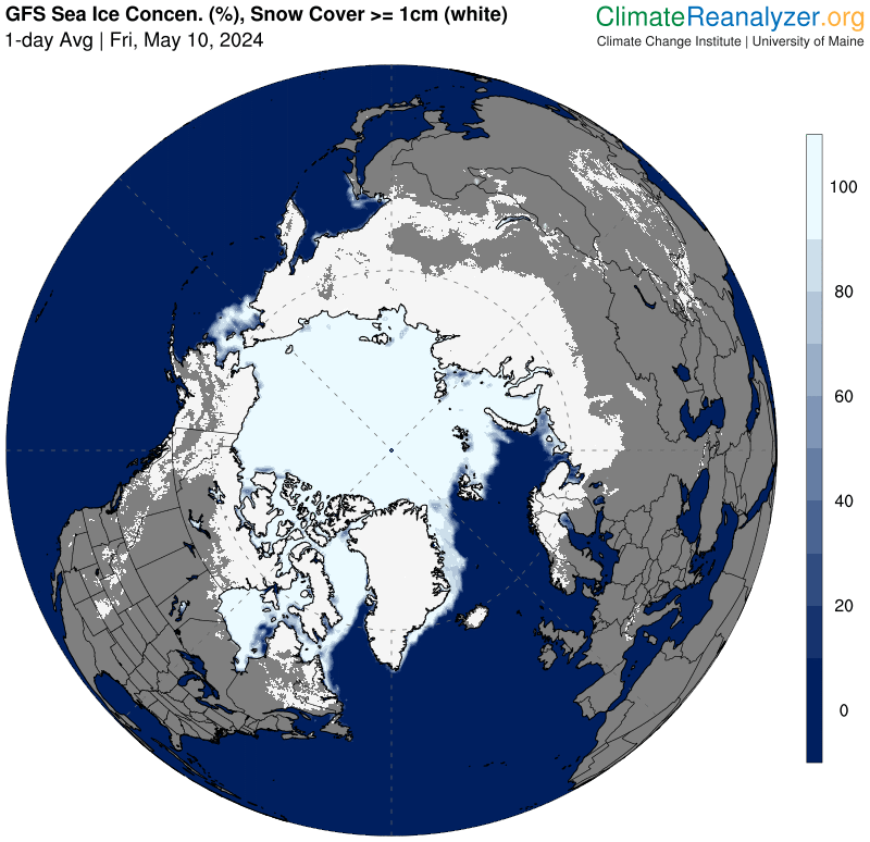
The Canadian Sea Ice Service is now showing lots of new ice (pink that appeared since yesterday) amongst the Canadian Archipelago. It seems to be in the places climatereanalyser has been picking it up for a few days already - reinforced by temperature maps. So, again, does climatereanalyser pick up the floating slushy snow and others don't until it hardens off? It often feels like it (based on previous years' observations, as well as this year). This ice chart confirms closure of the Northwest Passage to non-ice class vessels after a pretty solid 6 weeks open this year, though most would not risk it in -5C or lower, ,limited daylight, and heavy snow in slushy water turning to treacle, anyway. (Righthand top and side is NW Greenland above Baffin Bay for those unfamiliar.)

-
 5
5
-
 2
2
-
-
I think -3.7C was just the lowest number on the hour for Shap. The low was -4.0C.
Decoded synop reports
WWW.OGIMET.COM -
It's 3pm and 10-13C across Yorkshire currently, and we're on the warm side of the Pennines in wall to wall sunshine. The Lake district has some sizeable cold shower clouds holding the temperature back so it's only 7-10C there. Meanwhile in Scotland, radar and ski cameras suggest it's snowing down to about 800-1000m, with the forecast for that to drop to about 500m overnight. They are clearly already into the Arctic air their so it's no surprise that numerous Highland glen stations that won't see a great deal of sun are currently only showing 4-7C.
So there are already a sprinkling of single figure highs in NW England today and there should spread further east and south tomorrow.
Met Office WOW - Home Page
WOW.METOFFICE.GOV.UK
The UK Met Office Weather Observation Website (WOW). WOW allows anyone to submit their own weather data, anywhere in the world.-
1
-
-
Picking up slushy snow again? Last time it happened, it faded out in warmer areas over a few days but seemed to advance ice at the edge of the main pack and along the central Russian Coast. Also note how the main pack is "spiking" out to Wrangel Island, where DMI has shown a "streamer" of ice from the main pack hanging on all summer. So the ice is probably already there in a low concentration that is not picked up and displayed by some algorithms that have a higher threshhold.
-
3
-
2
-
-
"This shows the Northern Route is now closed"
Are you implying it was open prior? That bit of the Northern Route might have been open to non ice-class vessels for several weeks but DMI (reinforced by sea temp maps and the Alaska Sea Ice Program in part) suggests it's never really opened around Siberia and Wrangel Island. You can see ever present ice if you step back though the DMI series. I like to follow the attempts of small pleasure craft to through the Northwest Passage. That's been open 6 weeks on all sources and is now almost closed again but, in my book, the Northern Route/Northeast Passage has never really opened properly.
-
2
-
-
The Canadian Sea Ice Service also shows new ice growing out from the coast adjacent to Alaska. Temperature maps suggest much of the rest of th eneighbouring Canadian Archipelago is about to freeze up, even if progress is behind normal at the moment. The sea around the islands is around 0C to -2C whereas the new ice in the image below is actually in an area where sea is +2 or +3C. Any shallow areas or areas affected by residual snow or pack ice will be locally colder, though. Once a cold top layer of fresh water or slush is established, it's hard for the denser warm water to well up. (Below 4C colder fresh water is less dense and sits on top. Colder water only sinks through warmer, as we are familiar with, above 4C which is fresh water's densest temperature at normal atmospheric pressure - a bit lower for salt water, which complicates the issue. It's a good job or ponds would freeze solid to the bottom and kill most aquatic life rather than just freeze on top and insulate the rest if the pond from the atmospheric cold.)
-
3
-
-
Next weekend could be a shock after England's current summery weather. Note the latest run shows snow settling on the Northern Pennines. Anyway, most of the remaining clear, western Russian coast looks set for a good snowfall, with something significant for the Rockies as a bonus
-
1
-
1
-
-
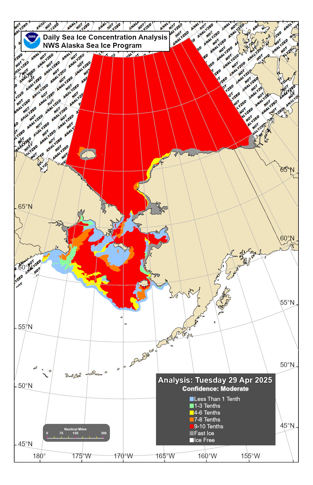
As well as ice now growing out from the central and Siberian Russian Coast, we've now got ice growing out from the Alaskan Coast, possibly helped along by all that snow. Unusually (?), there is even a little ice forming along the western coast of Alaska below the Arctic circle. I suspect some of this will be heavy snow that will melt out of maps again as it mixes into brinier waters. (You'll need to zoom in quite a bit to make it clear and the best map does not embed so click on the link to see that.)
NWS Alaska Sea Ice Program (ASIP)
WWW.WEATHER.GOV
-
4
-
-
Similar forecast for the Canadian Archipelago. Snow, snow, and then clears with temps to -15C.
Resolute, NU - 7 Day Forecast - Environment Canada
WEATHER.GC.CA
Current conditions and forecasts including 7 day outlook, daily high/low temperature, warnings, chance of precipitation, pressure, humidity/wind chill (when applicable) historical data, normals, record values and...This should bring rapid freeze up and closure of the Northwest Passage to non-ice class vessels - not that any are left there. They are long gone. It would be madness to sail through enough snow to destabilise a small yacht when you can't see either. 6 weeks is a good length open. Whilst some might worry about the warming, the Northeast Passage/Northern Route has not clearly opened this year. It's been sort of "maybe" for the last couple of weeks and probably full of slush from all the snow. If so, we'll see it freeze quickly as surface water will have little salt.
-
4
-
-
Is this a glitch or have huge swathes of Kara and Laptev suddenly started freezing? I'm guessing a glitch because the temperature map does not seem to back it up but there does look to have been a lot of snow dropped in that area of late.
-
3
-
-
- Popular Post
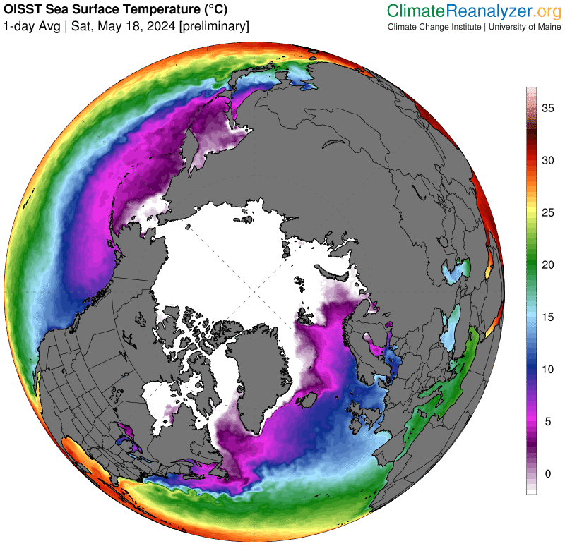
Take a look at this sea temperature map and note the edge of the coldest central white area is -3C. So there are another 3 bands before you get to 0C. This means snow falling on these areas will not necessarily melt and if it does, fresh water is densest at 4C so it won't sink, and even if it warmed to 4C, it is still less dense than seawater so fresh water might sit on brine if calm. That means snow is resistant to melting and mixing in the first three bands from the white area unless local wind or transmitted waves churn it up. If you get snow with low levels of wind, it will build up a slush on the sea surface, and possibly lead to a flash freeze when the winds of a depression move away to reveal a colder, calm high pressure. So the three bands from white are ready for a flash freeze as lows move away this time of year if there are no waves transmitted from distance. This is perhaps what happened in the East Siberian Sea recently.
Without snow forming such a slush, colder calmer weather in a high pressure can form grease ice/frasil at the surface where brine starts to freeze and newly forming ice "squeezes" the salt out to form fresh water crystals (or at least fresher as a bit of salt stays trapped). This freeze without snow takes rather lower temperatures to overcome the saltiness. Sometimes this might remelt in a subsequent warm spell but the fresh water is less dense for lack of salt and probably still colder above the brine so might well still sit on top if it remains calm, ready for a flash freeze again if it turns colder.
That's two different mechanism for flash freezes. There are simple principles at play but they can interact in quite complicated ways with other factors. I'm no expert but have read a little about it and just thought I'd describe a few points as we look out for flash freezes - or indeed any freezing. There's quite a lot of sub-zero sea towards Siberia and Alaska that has only just melted out and had lots of snow on it from the recent lows. I suspect plenty of potential for a quick refreeze, though it depends how much brine got churned up to the surface.
-
6
-
 4
4
-
MIA - Not so good a position?
I could maybe disagree. There's quite a large area of less than 10% ice around Wrangel Island and the sea above 75N is starting to refreeze as temperatures are dropping quickly now. The multiple low system going through at the moment could churn it all up but it's expected to drop lots of snow on already cold water (as well as add considerably to Siberian snow cover which will drop land temperatures). If there is a good slush build up from snowy lows, the stall could be set for calmer colder northerlies on the tail end to kick off a substantial refreeze of a large area that has only just thawed out (according to models that stop at a lower limit of 10% or 15% concentration of ice). There is a big cold area there ripe for refreezing quickly but it depends how much more churn there is in those lows.
-
6
-
1
-
-
Will this screenshot embed? Answer - No.
Just click on 6th box (NIC, Con) and delete others as you wish:
-
1
-
-
Good to see this thread back for another delve into the spread of winter. I used to live in the Pennines as a kid, and have happy memories of playing in 4 to 10+ foot snow drifts and unhappy memories of having to dig out through them, so I always wonder how winter will progress and If I'll ever see anything similar again.
I'm also interested in the sailing trials of those trying to get through the Northwest Passage. The NWP is already starting to freeze up early from the northern channels of the Canadian Archipelago after lots of snow. There is already doubt about it being navigable to non-ice class vessels in central areas after less than 3 weeks open during snow and colder than average weather (which followed a few weeks of very warm, sunny weather that helped it open). Numerous pleasure craft are heading west and south past Alaska, exitting the NWP into the Eastern Pacific. I've not been able to follow as closely this year but it looks like the number succesfully transitting the NWP will probably have made it into double figures. Although only open for a short period (so far) this year, it's been clearly open and numbers transitting are better than the last couple of years, even if falling snow will have made it tricky .
The Northeast Passage/Northern Route is still slightly blocked at Siberia but that is further south and could still possibly melt out briefly. There has been lots of snow everywhere, though, and plenty is in forecasts, so that could well remain closed to non-ice classes.
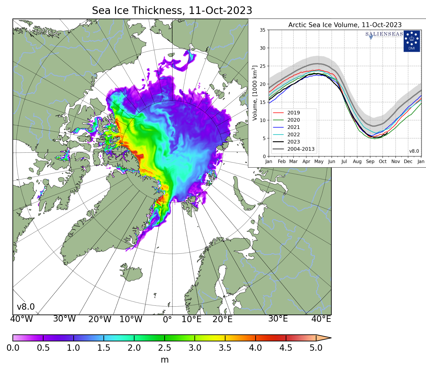
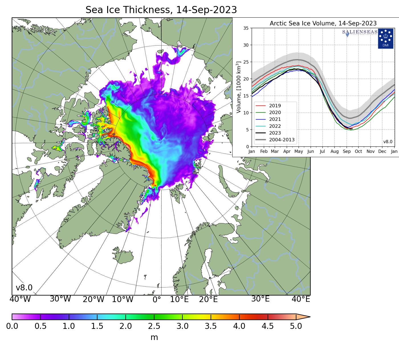
Https://ocean.dmi.dk/arctic/icethickness/images/FullSize_CICE_combine_thick_SM_EN_20230914.png
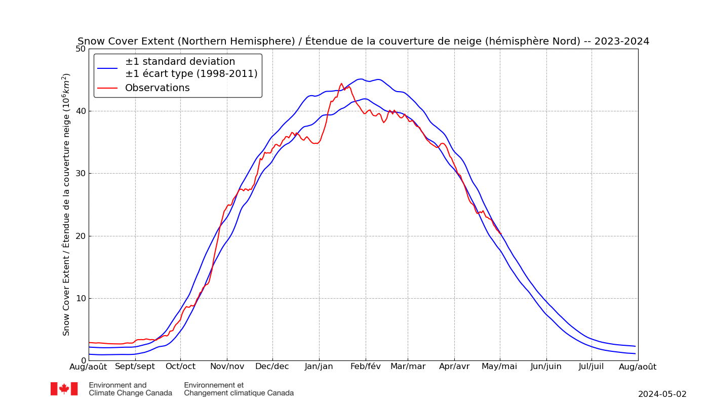
After a snow-free summer spell across the Arctic (which does not always happen), it's been very snowy for about 3 weeks. With lots more predicted, especially for Siberia, this is now showing more signs of settling.
The early start to winter snow extent expansion has eased back but this week looks set to push on again this week.
Https://ccin.ca/home/sites/default/files/snow/snow_tracker/nh_sce.png
-
7
-
1
-
-
Can anyone confirm if yesterday's -3.5C at Kinbrace was an all-time record low for September 13th in the UK? Wiki has the anytime September record at -6.7C 26/9/42 so it seems like could well be. A couple of independent stations recorded even lower numbers, with -4.4C lowest, suggesting the measurement was likely to be a realistic one. (More in "First Ground and Air Frost Watch" thread.)
-
1
-
1
-
-
The colder air has not extended fully down to the CET region. It's basically been cool in northernmost England and Scotland and only cold in places with no cloud at night. Look at recent weeks' cloud cover for Redesdale (Northumbria) and Aboyne (Grampians) for instance. I suppose the bottom of any glacial valley in the North could see a touch of frost if the weather is cool and it gets a cloud free night - even in July. The last couple of nights have only been a few degrees cooler than what normally happens in isolated spots anyway, I suppose.
Synop report summary
WWW.OGIMET.COM Synop report summary
WWW.OGIMET.COM -
Even colder - just. Tulloch Bridge again with 1.5C.
No. Location Station ID Amount
1 Tulloch Bridge (United Kingdom (the)) 03047 1.5°C
2 Loch Glascarnoch (United Kingdom (the)) 03031 2.4°C
3 Aviemore (United Kingdom (the)) 03063 3.4°C
4 Cairnwell (United Kingdom (the)) 03072 3.4°C
5 Aboyne (United Kingdom (the)) 03080 3.6°C
6 Bealach Na Ba No2 (United Kingdom (the)) 03039 4.7°C
7 Tain Range (United Kingdom (the)) 03062 5.5°C
8 Wick (United Kingdom (the)) 03075 5.7°C
9 Baltasound (United Kingdom (the)) 03002 6.3°C
10 Aultbea (United Kingdom (the)) 03034 6.4°C
11 Kinloss (United Kingdom (the)) 03066 6.5°C
12 Aberdeen / Dyce (United Kingdom (the)) 03091 7.1°C
13 Leuchars (United Kingdom (the)) 03171 7.1°C
14 Strathallan (United Kingdom (the)) 03144 7.9°C
15 Kirkwall Airport (United Kingdom (the)) 03017 8.3°C -
The odd Scot might have seen a touch of frost last night. Tulloch Bridge is 249m/817ft
07/21/2023 at 16:00 UTC
No. Location Station ID Amount
1 Tulloch Bridge (United Kingdom (the)) 03047 1.6°C
2 Cairnwell (United Kingdom (the)) 03072 3°C
3 Bealach Na Ba No2 (United Kingdom (the)) 03039 4°C
4 Eskdalemuir (United Kingdom (the)) 03162 5.4°C
5 Benson (United Kingdom (the)) 03658 6°C
6 Aboyne (United Kingdom (the)) 03080 6.1°C
7 Sennybridge (United Kingdom (the)) 03507 6.1°C
8 Pershore (United Kingdom (the)) 03529 6.2°C
9 Almondsbury (United Kingdom (the)) 03930 6.4°C
10 Exeter Airport No2 (United Kingdom (the)) 03844 6.5°C
11 Pembrey Sands (United Kingdom (the)) 03605 6.6°C
12 Redesdale (United Kingdom (the)) 03230 6.6°C
13 South Uist Range (United Kingdom (the)) 03023 7.1°C
14 Yeovilton (United Kingdom (the)) 03853 7.2°C
15 Shobdon (United Kingdom (the)) 03520 7.4°C
Script courtesy of Michael Holden of Relay Weather. Data courtesy of Ogimet -
Somebody probably did see a light frost in Scotland this morning.
07/21/2023 at 16:00 UTC
No. Location Station ID Amount
1 Tulloch Bridge (United Kingdom (the)) 03047 1.6°C
2 Cairnwell (United Kingdom (the)) 03072 3°C
3 Bealach Na Ba No2 (United Kingdom (the)) 03039 4°C
4 Eskdalemuir (United Kingdom (the)) 03162 5.4°C
5 Benson (United Kingdom (the)) 03658 6°C
6 Aboyne (United Kingdom (the)) 03080 6.1°C
7 Sennybridge (United Kingdom (the)) 03507 6.1°C
8 Pershore (United Kingdom (the)) 03529 6.2°C
9 Almondsbury (United Kingdom (the)) 03930 6.4°C
10 Exeter Airport No2 (United Kingdom (the)) 03844 6.5°C
11 Pembrey Sands (United Kingdom (the)) 03605 6.6°C
12 Redesdale (United Kingdom (the)) 03230 6.6°C
13 South Uist Range (United Kingdom (the)) 03023 7.1°C
14 Yeovilton (United Kingdom (the)) 03853 7.2°C
15 Shobdon (United Kingdom (the)) 03520 7.4°C
Script courtesy of Michael Holden of Relay Weather. Data courtesy of Ogimet -
That was a chilly one for July. It's just about possible that someone up early might have seen a touch of frost on their cars in a sheltered spot of Redesdale Valley.
Minimum Temperature Last 24h
07/20/2023 at 07:00 UTCNo.LocationStation IDAmount
1Redesdale (United Kingdom (the))03230 3.6°C
2Eskdalemuir (United Kingdom (the))03162 4.3°C
3Cairnwell (United Kingdom (the))03072 4.8°C
4Bealach Na Ba No2 (United Kingdom (the))03039 5.6°C
5Loch Glascarnoch (United Kingdom (the))03031 5.6°C
6Strathallan (United Kingdom (the))03144 5.8°C
7Aboyne (United Kingdom (the))03080 5.9°C
8Spadeadam (United Kingdom (the))03224 6.1°C
9Tulloch Bridge (United Kingdom (the))03047 6.3°C
10Shap (United Kingdom (the))03225 6.5°C
11Wick (United Kingdom (the))03075 6.5°C
12Islay: Port Ellen (United Kingdom (the))03105 6.6°C
13Aviemore (United Kingdom (the))03063 6.7°C
14Benson (United Kingdom (the))03658 6.7°C
15Almondsbury (United Kingdom (the))03930 6.8°C
Script courtesy of Michael Holden of Relay Weather. Data courtesy of Ogimet
-
2
-
1
-
1
-
-
Not a coldest by any means but -9.0C at Tulloch Bridge this morning is pretty chilly for the time of year. Also the -11.6, -12.5 and -12.5 they had a few weeks back is good going as well.
Synop report summary
WWW.OGIMET.COM-
1
-
-
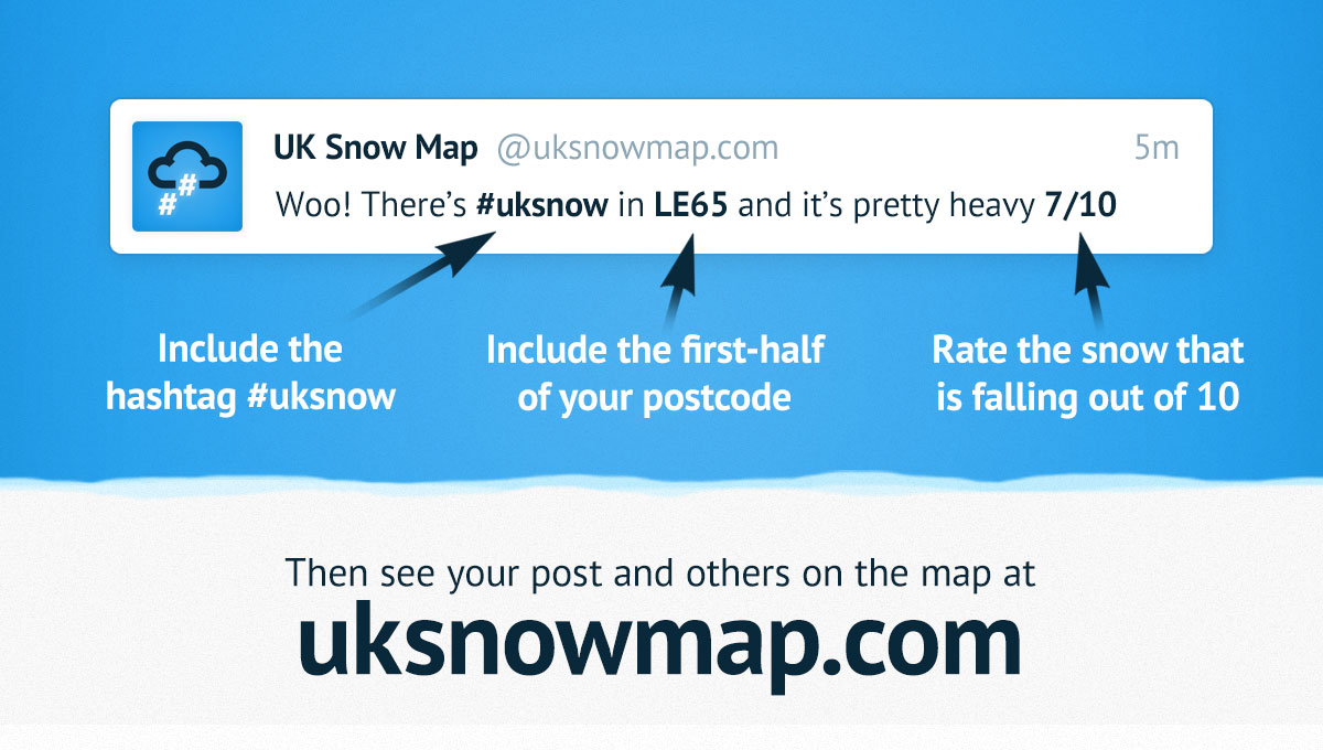
The self-reporting snow map seems active:
#uksnow Map
UKSNOWMAP.COMSee where it is snowing in the UK right now! UK Snow Map uses #uksnow Tweets to draw an up-to-the-minute map of where it is currently snowing in the UK.-
1
-
-
Can't find any independents to beat -14.7C at Loch Glasnarloch and -10.5C at Shap last night so looks to be a few degrees warmer last night than mid- December. Temperatures below Brum are generally not even below zero. We'll have to look to snow in the next day or two for the excitement.
-
Helen Willetts' forecast: "Coldest night of the winter so far - particularly for Scotland, -13 or -14." And then only showing -3s and -4s generally across northern England. I know rural temperatures often fall below urban by a few to several degrees but back in December we had below -17C in Scotland and below -14C in England, with widespread -10s on a few nights .... and Meteorologists say it's now Spring! I just can't see it being as cold as that spell - or the 3 weeks into January where a wide area had -6s with Benson hitting -10C.
Edit - current English lows are -7s in the Yorkshire Wolds and Rochester, Northumberland, but mostly a few degrees warmer across the North and above freezing in plenty of places - so still mild compared to those other two cold spells.
BBC Weather - Home
WWW.BBC.CO.UKLatest weather conditions and forecasts for the UK and the world. Includes up to 14-days of hourly forecast information, warnings, maps, and the latest editorial analysis and videos from the BBC Weather Centre.


Snow and Ice Northern Hemisphere - Winter 23 /24
in Spring Weather Discussion
Posted · Edited by Aleman
Wow. Been following the Northwest Passage sailing attempts for about 15 years and not seen a section freeze up like that in 24 hours before. It just shows how dangerous it is. Once you are frozen in, the polar bears can get you.