


Rascals Revenge
-
Posts
60 -
Joined
-
Last visited
Content Type
Forums
Blogs
Gallery
Events
Learn About Weather and Meteorology
Community guides
Posts posted by Rascals Revenge
-
-
Looks like towel whipping hasn't worked on the met computers!
-
1 hour ago, Summer Sun said:
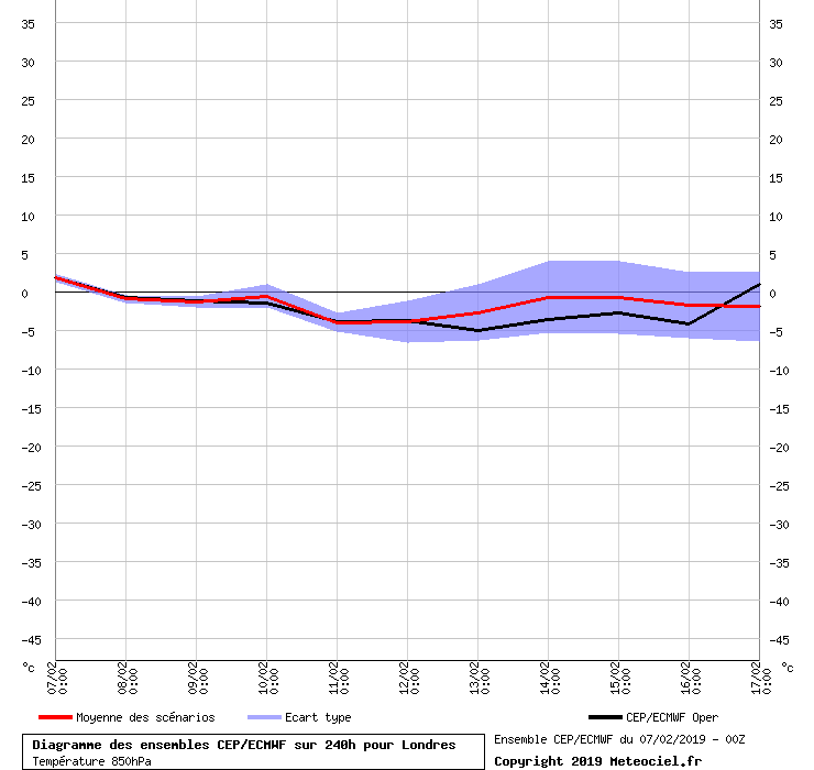
Past 3 runs from the ECM ens
Tuesday looks to be the peak of the cooler air
Thereafter place your bets a big shift towards something milder this morning around the middle part of the month then dropping back closer to average towards the end of the run
00z yesterday

12z yesterday
00z today
Are you Darren Bett?
-
 3
3
-
-
Stop looking at pages from Ceefax. The goods are coming.
-
Pressure rise towards Iceland. Trend is your friend.
-
Wheres the Beef?
-
2 minutes ago, pacifist99 said:
Is that a good thing or do you have evidence to back up this statement. Sorry dude but this is exactly why this thread has gone downhill ever since the mods split it
Yes, history.
-
1
-
-
We are just about to endure the classic mild spell before an easterly. The goods are coming.
-
3
-
-
3 minutes ago, bluearmy said:
As mulzy mentioned, seeing the mean euro high anoms dispensed with by day 14 is a step forward. Assume clusters will show some euro low anoms and in conjunction with a trend to higher anoms to our north we may be onto something - let’s hope whatever it is accelerates as would rather see cod arrive by 15/20th. Last years BFTE has uppers and thicknesses that were pretty extreme and I wouldn’t expect that to repeat. the earlier the better as the month progresses.....
Last year's 2nd bfteast appeared at very short notice. Im expecting the same before the end of feb.
-
UK Outlook for Sunday 17 Feb 2019 to Sunday 3 Mar 2019:
Very low confidence emerges through the rest of February as to whether a more blocked pattern redevelops or we maintain more of an Atlantic influence, with a more widely unsettled theme continuing through second half of the month. At this stage, it looks as though Atlantic low pressure systems will track further to the south, with high pressure situated to the north. This set up would bring slightly wetter conditions across the south of the UK, with some strong winds at times. Meanwhile, drier than average conditions are likely in the north, although with some coastal showers possible. There is the possibility that frontal systems may bring wintry hazards, particularly if a more east or northeasterly flow develops. Temperatures overall around the average. Low likelihood of widely cold conditions developing.
Think the fat lady is clearing her throat!!!!
-
3 hours ago, Summer Sun said:
GEFS out to Feb 18th says make the most of what's left of this cold snap
Mild ramper
-
2
-
 1
1
-
-
It is Groundhog day today. I wonder what Punxsutawney Phil will say later.
-
2
-
-
Updated again
UK Outlook for Saturday 16 Feb 2019 to Saturday 2 Mar 2019:
The most likely scenario is for the weather to get colder again from mid to late February, however confidence is low. The most common weather in this period is likely to be cold days with occasional wintry showers, and frosty nights. However, some rain and unsettled weather remain a possibility, especially in the northwest. There will also be milder spells though, most likely in the south. Towards late February a longer cold spell looks possible, perhaps due to winds from the east, however it is too early to say for sure, and there is also a chance that milder and wetter weather will arrive from the Atlantic.


Meto Uk Further Outlook
in Spring Weather Discussion
Posted · Edited by Rascals Revenge
To be fair,they got 2009 2010 2013 2018 spells well in advance.
But they should now really give into defeat. Its now a running joke.