


Mark Smithy
-
Posts
605 -
Joined
-
Last visited
-
Days Won
1
Content Type
Forums
Blogs
Gallery
Events
Learn About Weather and Meteorology
Community guides
Posts posted by Mark Smithy
-
-
3 minutes ago, Vikos said:
One you say it’s not an outlier, next post it is… confusing.
No it's not confusing. I thought it had support from a couple of members but only a couple. But then on very close inspection it does actually head off on its own right at the end. So technically it does have an outlier couple of days to it:

The main issue is that only a couple of members support the operational. The vast majority trend mild.
So don't pin your hopes on something with such little support. Not unless a whole cluster of others come on board.
-
 4
4
-
-
The ECM continues to show height rise to our south, which leaves us in alternating mild and cold meridional interludes. Ignore this at our peril. This for example at T240 isn't a pathway to cold ... at this stage:
-
2
-
-
Just now, iowpompeylee said:
It’s is called the model output discussion, that obviously covers the whole output! People look Mainly for trends. Sometimes it comes off sometimes it doesn’t haha
Yep the problem comes though when people cast their subjective wishes onto model outputs and lose objectivity. It happens a lot, this morning being a case in point.
Fact is, as far as this stage of the model outputs goes, that we're heading for a mild breakdown this weekend and the exciting 0z GFS operational was an outlier.
Back to humdrum UK winter weather: mild and meridional cold interludes. Anything more is straw clutching.
-
5
-
 1
1
-
-
Just before anyone gets too excited at the 0z GFS, here's a reality dose:
It's not an outlier [edit - well actually it is at the end] but it sure doesn't have a huge amount of support.
The likelier scenarios are the ECM. Which means mild westerlies with occasional colder incursions. Basically back to something more hum-drum.
At least, until or unless more GFS members start to show what the operational did.
-
3
-
1
-
-
27 minutes ago, Johnp said:
Looks cold to me. How are you not seeing this?
Run the sequence through and watch the synoptic flow left to right. That's not a cold 'set up' it's a very brief interlude in an otherwise mild flow. Check the high pressure to our south and the mild run of south-westerlies building in.
It's clear right now: GFS, ECM have the UK heading mild next weekend. So does the UKMO. But see my previous comment for the detail. With a resident European High we will still get occasional colder forays esp in the far north.
Make the most of this cold if you like it because the latest model outputs don't favour it sticking around.
-
5
-
3
-
-
There's perhaps a slight tendency to look for the best possible upstream signs and most obscure models or ensemble members within the mainstream ones.
I think we need to recognise that the main models all now have a blocking high pressure build showing up. It's just in completely the wrong place for UK cold. If this high takes hold over southern Europe / the Alps then we will be in an Atlantic draw with occasional colder interludes for the Scottish mountains.
-
2
-
1
-
 1
1
-
-
20 minutes ago, Mike Poole said:
UKMO back to its position yesterday morning of not phasing the lows (the one to the south keeps its identity) so we keep the cold air,
This isn't a synoptic cold set up from UKMO.
GFS robust in a weekend breakdown and there was solid ensemble agreement in the 18z for the first mild phase. The 0z GFS doesn't deviate from the mild conditions.
Looking ahead, all three main models are positing a high pressure build to our south or south-east over continental Europe. This often means no route to cold in the UK.
-
1
-
1
-
-
2 hours ago, blizzard81 said:
Ignore the south westerlies. This chart is jam packed full of potential. Balmy south westerlies in conjunction with a northern hemisphere profile like this is how many if not most of the classic old skool snowy, freezing cold spells started.
I'm afraid this is a classic example of straining at gnats and swallowing camels.
There's a bloomin' great Euro High developing if we're not careful. You can have all the PV splits and high pressure cells over the north pole you like, but if we get a resident high over the continent (south of Scandinavia obvs) then you most certainly cannot ignore the south westerlies.
The mild breakdown next weekend does now look pretty likely. All 3 big players have it coming in. Thereafter? Don't bet against the form horse winning through: mild.
-
5
-
1
-
-
- Popular Post
Just back from a bitterly cold but beautiful 5 mile walk.
Well, those of you who believe that the cold will come back after it (probably) briefly departs will be very heartened by the finale to the 6z GFS run. Scandinavian High Pressure returns and another bitter easterly sets in:
Boxing Day 1962 was the start of the Great Freeze winter of 1962/3. Just saying
 .
.
-
13
-
1
-
Anyway, I wish you all peace.
Only time will tell.
 Just now, TSNWK said:
Why an earth are we discussing the likely mild breakthrough in 6 days time when presently we are locked in cold with unexpected snow events popping up. Is that not what us coldies look for. Enjoy the moment.
Because this is a model output thread not a daily snow report
-
8
-
1
-
-
The danger here is cherry picking what we want to see versus the empirical reality of how the main model outputs are trending. There is definitely a signal to mild 6-7 days from now.
That doesn't mean it's a done deal. Judging by the ensemble spread on the GEFS for instance I'd say it's somewhere between 70:30 and 80:20. Whilst the 0z operational is on the mildest side there are only a couple of members which don't trend mild at the key point:
-
3
-
-
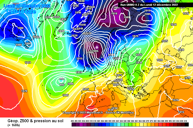
1 minute ago, MJB said:
No they don't UKMO is cold throughout or have I missed something
Well clearly we're not comparing like for like and it's always dangerous to suppose how a model output might head after, erm, the model output finishes. However, this T168 final chart is not a promising set up for ongoing cold. Like the ECM, there is substantial height rise to our south building here (1024mb) and when you ally this with the west to east movement through the frames, this is not a recipe for ongoing cold:
-
2
-
-
1 hour ago, KTtom said:
Indeed KTom. I don't think you and I are likely to make it into the Echo Chamber thread anytime soon but the likely inconvenient truth has to be aired.
It's not a done deal but it's the likeliest.
The real problem would be that ECM T240 set up with a high pressure over southern France / Spain / North Africa. They can be difficult to shift and leave the UK in mild south-westerlies.
Good for the pesky heating bills though.
-
2
-
-
31 minutes ago, Day 10 said:
Good morning,
I have put all 6 main outputs together at day 6 to compare where they sit with the incoming low out in the Atlantic, I still feel this is far from a done deal with milder air blasting through. A lot can still change in 6 days.
At the minute we have the ICON, UKMO & GEM the best options
I'm afraid the flaw in your argument lies right at the outset. There aren't really "six main outputs".
There is a clear hierarchy of reliability with 3 main model outputs: GFS, ECM, and UKMO. All 3 of the main outputs suggest milder outcomes at around the 6-7 day point.
It's not a done deal but once we start scrabbling around for minor model outputs to back up our preconceived wishes then we're not really being objective or empirical.
Based on those 3 and the ensembles it's somewhere between 70:30 or 80:20 that it's heading milder.
-
1
-
-
4 minutes ago, snowice said:
Agree trends now for a few days of milder spell, will the cold come back for xmass??.
I'm not sure. At present I can't really see evidence for it and we would need to lose that high pressure to the south. If that takes up residence then it will stay mild.

-
3
-
1
-
-
There's no doubt that a mild breakdown next weekend is the favoured option in the models now. The ECM is particularly grim viewing for those of us cold lovers, although good news for those of us struggling to heat our homes:
6-7 days is still quite a long time and not all ensembles members agree with the mild option.
I'd say 70:30 0r 80:20 that we're heading mild.
-
1
-
1
-
-
39 minutes ago, damianslaw said:
Interesting GFS latest, don't usually dwell on timescales so far out, but it looks like any atlantic push will be forced to retreat southwards, some sort of battleline over N Britain, cold undercutting and low pressure then swings SE and we are back to a northerly..
When you say 'it looks like' I think this needs to be qualified by the ECM which doesn't show that.
By the way I want to add that whilst I admire this idea of cherry picking everyone's favourite comments into a curated separate thread, the danger is that it just becomes an echo chamber.
Much as we cold lovers don't always want to hear voices of caution they can be important signposts.
-
4
-
-
5 minutes ago, sheikhy said:
This aint a done deal yet!!12zs could shift again!!besides still very cold for the next 8 or 9 days!!!
It could and you're right, it isn't.
The general trend for the past few days has been for more ensemble members and operationals to trend milder. The 0z ECM is not a good sign and some may see this as a final nail.
However, the timeframe of 5-7 days still means that this is outside of reliability and sometimes cold spells are slower to shift than models recognise.
So yes there is still hope.
-
1
-
1
-
1
-
-
Just taking a step back, the truth is that we don't really have proper blocking. Don't shoot me down for saying so but the easterly was a lot less pronounced than the models were originally suggesting, mainly because instead of a proper building Scandinavian High, we had low pressure in that region, pulling down a bitterly cold artic air mass. So we had an easterly flow for a couple of days, followed by a north-easterly veering northerly.
In the short term this made the cold spell a LOT colder but it may prove to be a Pyrrhic victory: a short term gain for a lot more pain.
What is absent from the latest models, in spite of Crewe Cold's aspiration, is a proper blocking high pressure build in the medium term.
-
3
-
5
-
-
53 minutes ago, joggs said:
Ukmo looks decent but GFS a horror for prolonging this cold spell.
The GEM is the real horror show:
But that's at T240 and it's just one run.
UKMO still keeps up the cold but if you could roll on past T168 it looks like a movement west to east even with them.
GFS operationals are certainly going for a breakdown at present but there's still considerable scatter in the ensembles, even at short range, with some members showing milder conditions sooner than next weekend. Others take the UKMO route to prolonging cold.
The ECM will be interesting.
Next 24 hours may be make or break in the model outputs for how long this cold spell is going to last.
-
Well I have to confess to being quite disappointed by the 06z GFS ensembles. I thought the operational would be out on a limb - it is - but I'd expected a lot more colder members.
I don't like the trend in that set of ensembles and we could do with seeing it bucked in the next few runs.
Fortunately the UKMO and to a slightly lesser extent the ECM are still very much in the cold zone. The next 24-48 hours of model outputs could be fairly decisive one way or t'other.
-
3
-
-
Do you think they'll get around to unlocking the model output thread
Just now, feb1991blizzard said:wont be any model discussion till they unlock thread.
SNAP!!
-
1
-
-
The 6z GFS is a bit of a horror show (for cold lovers) with a very mild, even warm, finale.
I'm expecting it to sit out on a limb on the ensembles but, even so, it does illustrate that this is far from nailed on. It remains on a knife-edge
-
0z GFS Operational very much on the mild side:
One thing that is really noticeable is that the ensemble scatter is no longer occurring on Dec 14th but Dec 17th. So the possible mild breakdown has been pushed further back.
-
8
-
1
-


Model Output Discussion - the cold has arrived
in Forecast Model Discussion
Posted
Generally speaking high pressures that take residence over France / Spain / the Alps are bad news for UK winter cold.