


Tills
-
Posts
36 -
Joined
-
Last visited
Content Type
Forums
Blogs
Gallery
Events
Learn About Weather and Meteorology
Community guides
Posts posted by Tills
-
-
Just now, nick sussex said:
The ECM delivers the final insult to coldies .
A west based negative NAO.
Theres just one cluster post T264 hrs . Initially there might be some colder air heading south but by T360 hrs the block is too far west .

Given the timeframes involved we can just hope that this isn’t the final outcome .
Yes I mentioned above that the ECM has a very different scenario to GFS. The advent of the high slipping, splitting, or extending from Scandinavia into northern Europe is one which will be all-too familiar to cold seekers.
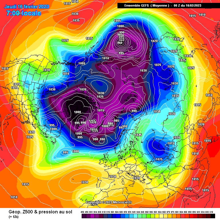
There are massive variables out beyond 200 hours. As many as I've seen in a long time, which you can clearly see in the GEFS ensembles.
-
29 minutes ago, BLAST FROM THE PAST said:
There is no setback and there is momentum. High builds over and retrogression after. Where’s the setback? And don’t say the depth of cold from the first HP cell, that isn’t and never was going to be the real cold shot
BFTP
Jury very much still out Fred.
ECM shows a different scenario to GFS and with so much variation of possible outcomes in the GEFS ensembles there really is no guarantee of what is going to transpire next week onwards into March.
-
 4
4
-
-
Jury very much still out on next week with considerable doubt about direction of travel.
I don't normally follow means in any field but has anyone ever conducted a proper empirical study to see how accurate the GEFS model output mean is from ensemble forecast to reality?
I am specifically asking about the GEFS mean, nothing else.
-
37 minutes ago, BLAST FROM THE PAST said:
It might know what is right but it seems pretty unsure of itself?
No real support from the ECM. UKMO extended doesn't look particularly positive for a cold setup either. Not to mention last night's 18z GFS run.
We are, or should be, still a long way from sensible talk about record cold in March. It might just as easily be the opposite if ECM is right. No guarantees right now that the ssw is going to play out for any downstream cold in the UK as yet. Can we keep our feet on the ground for now?
Original post: https://community.netweather.tv/topic/98326-model-output-discussion-into-february/?do=findComment&comment=4807285 -
7 minutes ago, BLAST FROM THE PAST said:
f real cold in March, and pieces are all falling into place for this one.
Sorry but no meteorologist, amateur or professional, can state that about something that is 2 weeks away. It's just untrue.
It might happen but it still needs a stack of things to come right and there are masses of variables in the mix between now and then. SSW is only one factor in what will drive that.
If all the ducks line up 5 days out then we can talk of 'all the pieces falling into place'. Otherwise it's one possibility out of many other scenarios: hence the GFS scatter I posted.
-
4
-
-
37 minutes ago, BLAST FROM THE PAST said:
It might know what is right but it seems pretty unsure of itself?
No real support from the ECM. UKMO extended doesn't look particularly positive for a cold setup either. Not to mention last night's 18z GFS run.
We are, or should be, still a long way from sensible talk about record cold in March. It might just as easily be the opposite if ECM is right. No guarantees right now that the ssw is going to play out for any downstream cold in the UK as yet. Can we keep our feet on the ground for now?
-
 4
4
-
-
4 hours ago, s4lancia said:
Irrespective of to what degree different people understand charts, teleconnections, background signals etc, the same problem resides in this forum.
There are those who only seem to look at charts at face value. i.e... a set of 4 x daily GEFS plot, which are showing nothing particularly spectacular on the horizon. And there are those who are willing to open their minds to what is going on upstream
As a newcomer to this thread I would observe that one of the problems seems to reside in a disconnect between what people want to see and what the models are actually showing.
As a lover of skiing all over the world I know for a fact that our climate has changed in the past 20 years. The setups which we once took for granted are now rarer than a hen's teeth. That's another driver amongst many that we now need to factor in to our model watching. Not just how brilliant upstream signals may seem.
xx
-
6
-
 1
1
-
-
1 minute ago, CreweCold said:
There’s no right or wrong when it comes to forecasting preference. You prefer shorter range whereas I prefer the longer range stuff I.e broader scale trends.
Both approaches are as equally valid.
There are people on this forum who knock it out of the park when it comes to forecasting on a close range micro scale basis. They can pin point within miles where rain/snow boundaries will occur, for example. They know the atmospheric conditions from top to bottom in any given location at any given time.
On the other hand we have people who excel in the forecasting of the broad scale hemispheric circulation. They can forecast weeks in advance based on likely evolution of atmospheric drivers and background signals.
Everyone has their part to play on here and if you’re comfortable with shorter range modelling then that’s great

Thanks for this.
I'm not sure though that I am comfortable describing GFS as short range when it goes out to 2 weeks? Even ECM is out to 10 days. Conventionally that's considered Medium Range modelling.
Medium Range and Long Range are not like-for-like comparatively. Confidence drops markedly in model outputs at roughly 5 day and then markedly again at 10 day.
I confess to having very very little confidence in models beyond day 10, based on years of weather watching. It's true that they are vastly improving thanks to wonderful technologies but they are still notoriously inaccurate.
My point really is that for sustained cold to develop off a SSW fuelled switch I would expect to see a Greenland High or northerly block showing up by now in the medium range models: at around days 10-14. The ECM at 240 hours is currently showing the opposite of that with what looks like a pretty resurgent Atlantic in the offing.
Still time for change of course.
-
3
-
-
8 minutes ago, CreweCold said:
There won’t be. They’re short range NWP.
Pretty much every longer range product shows a strong +ve Greenland height anomaly for March.
Fine and you are entitled to refer to long-range modelling as much as I am about the more conventional model outputs. I know which ones I trust more. Long range modelling forecasts are notoriously inaccurate and I would point out that the absence of any Greenland high pressure right out to 14 days inspires little confidence in me that cold is coming. In fact that ECM chart I posted at 240 hours is a classic recipe for Atlantic-driven weather.
This is I fear a case of Waiting for Godot, the irony of Samuel Becket's brilliant play being of course that they wait and wait and wait ... but Godot never appears.
-
3
-
-
-
13 minutes ago, IDO said:
Looking at trends and looking good for a cool down next week (London) as the high slowly falls from the Atlantic:
Nothing of significant note, but the 2m temps are below average. Maybe three days of circa -5c (mean) 850s. The slowdown of the westerly flow is probably attributed to a more pronounced Pacific ridge (mean):
A mean pressure rise for the UK from the rest of the run into March, where we are expecting changes to start appearing:
Yes indeed.
Currently there is no firm evidence for a cold March, let alone a 'record breaking' one. That may yet come of course but the point is that it isn't showing up in the models.
The ECM in fact would lead to a mild and Atlantic-driven outlook with notable low pressure coming off the eastern seaboard.
-
2
-
1
-
-
18 minutes ago, KTtom said:
Pretty much took my words away. High pressure pretty much all the way (initially cloudy) then a glancing polor blow around the 23rd, then looking like a sunnier high takes over. Far reaches of the gfs now into March, nothing to get excited about yet. Lack of rain will shortly be an unwelcome topic.
Yes indeed KTtom. They were reporting last night on the BBC that large areas of England have only seen 1 mm of rain in the last 4 weeks.
There will be some dribbles over the next couple of days but barely enough to measure I suspect.
-
2
-
-
Nothing of any note on the ECMWF. Like the UKMO out at 168 hrs it has a grazing northerly which will affect mostly the north-east.
Out at 240 hrs it then has the high pressure a little further south than the GFS, allowing more of an Atlantic feed:
If this SSW is having any effect then it isn't yet showing up on the models.
-
1
-
1
-
-
Coming into Spring and that high pressure really does not want to budge. At least according to the GFS. It has become as stubborn as a mule or, in rather less pleasant language and depending on your predilections for weather, an unflushable turd. Might be really gorgeous Spring conditions under this:
There is no sign of a cool down for the UK.
11 minutes ago, Nick2373 said:Its been trending for days, spring on its way or could we see a flip but going off the set up of late with highs just booting around the UK I know what the likely hood is.
Yep it really does not want to budge
-
2
-
-
54 minutes ago, ANYWEATHER said:
Looks like another wild goose chase .......

This is what I am struggling with.
The model outputs in reality show very little support currently for SSW-driven cold over the UK.
Instead the most dominant feature on all the model outputs is a massive and persistent high pressure cell over Europe and / or southern Britain. That is one hell of a stubborn mule to move and it is likely now to carry us into meteorological Spring. Everytime we think it is about to shift it comes back like an unflushable turd.
Cold incursions during March and April are to be expected but there is no sign of a 'Beast from the East' at present.
I am learning that this is not what many people on here want to read but it is surely the present reality of the outputs?
-
1
-
-
Heading into Spring (01st March) and this high pressure is incredibly persistent. No signs of cold nor indeed a possibility of cold with this parked over southern Britain / the Continent.
-
3
-
-
Mild all the way out to the end of winter (28 Feb) at the moment in the model outputs with a persistent high pressure either over southern Britain or the near Continent.
Moist and mild over the north of Britain is bad news for the ski industry in Scotland where there is currently no skiable snow. I really feel for them. A few weeks back when I went out to the Alps it was a reverse situation. Now the snow is gone up north, whilst the Alps has powder blue skiing.
-
1
-
1
-
-
31 minutes ago, alexisj9 said:
Also I think the models are reverting to climatology, as they haven't got a clue what's going on during the warmings. Guess we'll see in a week or so's time.
Or maybe they do have a clue and they don't think the impact will outweigh other factors driving the UK's weather?
Anyway, just now there's little or nothing showing in the model outputs to alter the generally mild pattern with moist conditions in the north off the Atlantic feed. And some welcome rain on Wednesday/Thursday for southern Britain.
-
2
-
-
Some welcome rain for us gardeners in the south:
The north should continue to have plenty:
-
4
-
1
-
-
On 10/02/2023 at 09:01, Ruzzi said:
I don't think anyone has said at any point that a SSW guarantees cold weather ...
We're here to enjoy the ride of seeing how it plays, a SSW doesn't guarantee cold and snow, but it gives us a ticket to the raffle and that's where the thrill of the chase comes in.
If you want spring and warmth, maybe best not to hang your hat on it for at least another few weeks until the effects of the SSW are laid out a bit clearer.
This is what I am not getting about this thread. I have come on here to see what is happening in the model outputs.
Instead most of the posts seem to be by those wanting bitter cold about an atmospheric event that may or may not happen and which may or may not have a cold impact in the UK in 2 to 4 weeks time. Very little about the actual model outputs from which I want to learn.
Shouldn't there be a separate thread where people without bias or particular weather preferences can just discuss the actual model outputs instead of what they are wishing to see?

Nothing that I have seen in the outputs overnight suggests anything other than a mostly stagnant high pressure south of Britain maintaining a mild flow especially in the north? Am I wrong?
-
7
-
1
-
-
10 hours ago, Uncertainty said:
I think you’re gonna be right Pete. We’ve said it all along. March is going to be mental
I came on here to see what the models outputs are showing us for the last two weeks of winter.
So I have a genuine question.
Is this truly a model output discussion thread?
Or is it a teleconnection SSW thread seeking upstream signals that might [possibly] affect our weather some time in the distant future?

xx
-
4
-
3
-
-
5 hours ago, skifreak said:
Some serious pish gets posted in this thread.I looked on this thread and was as surprised as you. It is only 2 weeks since huge swathes of the west of Britain were under severe flooding from that "dead" Atlantic. Also I was up in the North-West during a recent gale when it blew a hoolie. The first half of January was incredibly wet and that didn't come from the east.
If you look at the charts right now the Atlantic is still far from shut down if you are in the North-West of Britain. There is a high cell over southern Britain but that is getting moved east too with mild south-westerlies coming up the west side and around the top.
-
2
-
-
It's awesome here now!
45 minutes ago, carinthian said:Well would you believe it . One of the forecasting agencies has just issued Warnings of Heavy Snowfall with immense totals expected over the next 2 weeks. North and Western Alps at greatest risk , especially North Tyrol and Silvretta with accumulations of 2.5 m and avalanche risk increasing to 4.5. Must have gone with the ECM model that shows quite deep troughing into Europe in the extended period. However, this is not the agency we use out here but nevertheless of great interest. The last time they issued a similar warning was for the heavy snows experienced in Ost Tyrol a few years back as shown in the picture below in Obertilliach, East Tyrol
C
Can you provide a link to that Carinthian? The underlined one doesn't work and I'd love to see the link if possible x
-
4
-
-
Snow!!!!!!!! Blizzards. Loads of new snow.

-
2
-
1
-


Winter 2022/23 - Moans, Ramps & Chat
in Spring Weather Discussion
Posted
About the most sensible thing I've read on here.
And that's where the problems seem to come too: people tending to read into the models whatever they want and then finding evidence for it. There are charts showing cold and there are charts which don't.
There are signs of cold but they're inconclusive and still a long way away. And seasoned weather watchers will know that however likely something cold looks in the models, these days more often than not it doesn't seem to click in the UK.
I do also agree though that March can be a miserable month. It's neither one thing nor the other: it's rare to get proper snowy cold out of it. Anything white which does fall usually seems to turn to slush pretty quickly. On the other hand it can be a raw month when spring still seems a long way away. It can be neither winter nor spring.
And that's pretty much where the models are right now: a curate's egg. And that's what I suggest will happen: a mixture of some mild days and plenty that are bloomin' cold.
It's perfectly possible that no-one will be happy this March