


dinger
-
Posts
55 -
Joined
-
Last visited
Content Type
Forums
Blogs
Gallery
Events
Learn About Weather and Meteorology
Community guides
Posts posted by dinger
-
-
Well guys, looks like us soft southerners are finally going to get more than a dusting

I wonder what it would take for a Met office 'take action' warning for very heavy snow in Scotland!?
I think we might get past the Advisory stage if conditions mimicked that film with Dennis Quaid - You know, the one with freezing helicopters and stuff, I think there was some snow in that as well
. GFS and the METO failed to pick it up and the General Model discussion was full of IMBY's and NIMBY's
Hope you get your snow buddy
-
Well guys, looks like us soft southerners are finally going to get more than a dusting
I wonder what it would take for a Met office 'take action' warning for very heavy snow in Scotland!?
I think we might get past the Advisory stage if conditions mimicked that film with Dennis Quaid - You know, the one with freezing helicopters and stuff, I think there was some snow in that as well
. GFS and the METO failed to pick it up and the General Model discussion was full of IMBY's and NIMBY's
Hope you get your snow buddy
-
yeah thats amazing statistics giving your location, will be an interesting drive for you tomorrow. Also I think catchmydrift looks as if he has had a good top up judging by the radar will see when he comes on
CheersScott
He only saw snow because he was driving to Edinburgh everyday
Any way I'm off out for a walk. It's not often I get this
-
http://www.sat24.com/image.ashx?country=scan&type=slide&index=12&time=&sat=
It seems to be forming into something swirly and big and also dragging that big lump from the North of the Shetlands along with it.
Are you sure it's not a Polo!!
-
Maybe CMD or Mondy can help with this one but is that a (Shhhh!! PL) developing just South West of the Faroes :huh:
http://www.sat24.com/image.ashx?country=scan&type=slide&index=12&time=&sat=
-
have looked on the traffic cams but cant seem to find any in Edinburgh that show it is snowing
try Soutra near Penicuik :huh:
-
Don't want to be a harbinger of doom but from watching the radar the front appears to be losing it's intensity as it approaches the central belt.
Even though we've had lying snow and ice here since before xmas I have yet to see it fall as I have always been working at the coast where it's been p**hing with rain. 'Mon the snow :lol:
-
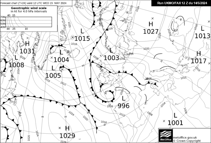
Having a look at the current fax chart for tomorrow at 12 http://www.meteociel.fr/ukmo/fax/fax24s.gif
There's all sorts going on. Potential almost anywhere for the white stuff.
Who'd be a weather forecaster lol. Good luck sorting that one out
-
First chance I've had to look at charts and radar today. It looks as though there may be a slight chance that the showers might make it across the central belt in the next hour or two.
Also had a look at the Sat24 site and there appears to be something a little more organised heading off the Norwegian coast towards our Northern Shores. I hope it remains stable enough to keep some moisture for us
-
Snowing lightly here which is a total surprise because there was nothing on the radar but showers seem to be beefing up across the central belt from nowhere.
It would be amazing if a streamer situation developed but it appears mother nature keeps throwing up surprises now and again :lol:
Looks like Fife is due a battering shortly :lol:
-
New fax charts look promising for us all on Saturday
-
Thought I would add these that I took this afternoon with my mobile on my way back from the co-op.
The first one is of the River Irvine from the 'Muckle Brig' in Galston, the other two are on the short cut at the back of the store
-
Hi Ross. Just up the road from you in Galston. Hope the hills don't take more than their fair share and leave us enough to build a decent snowman. Haven't had a decent dumping here for years
Colin
-
I don't want it to seem like I'm championing RJS and BFTP but their original post on the 7th November now reads like a historical account rather than a forecast.
Exceptional stuff guys. Keep it up :lol:
-
Having read the previous posts by JH and Paul I can appreciate that other forecasting methods were also available for predicting the colder spell in November.
What has impressed me more than anything else,however, is that the method used by RJS and BFTP and their subsequent forecast was date specific to the period 11th - 14th December. (written 5 weeks before the event)
Ok not everyone experienced a 'Storm' but some parts of the UK took a pasting and now it appears that the milder period as per the forecast is beginning to bear fruit.
Keep up the good work guys. Any idea when RJS will be posting an updated forecast
-
Quick question and forgive me if it's already been asked.
I believe that it is officially a white xmas if a flake of snow falls on the roof of the met office.
My question is - Who looks for it? I mean is there 2 people doing a 24 hr shift watching for a single flake and do they have to corroborate each other.
"LOOK there's a snow flake!"
" Where?"
"THERE! look to you're right, damn it's just went past the guttering"
"Sorry mate missed that one"
" It's OK, it doesn't count anyway it never hit the roof"
It also opens up all sorts of other questions like
What happens when one of them needs the toilet?
What if they've got a big bet on it being a white xmas?
What if they're looking one way and the snow falls behind them?
What if they are too busy texting each other?
and so on..........
I know it's a sort of 'how does the man who drives the snowplough get to his work in the morning' sort of question but it's really bugging me.
A definitive answer would be appreciated thanks :lol:
-
Both were extraordinary snow events for me. Hogmany '78 was amazing but I was only 9 so don't really remember the hardships that go with such an event.
Xmas '95 was fantastic, started snowing xmas eve and it took me an hour and a half to walk the half mile home from the pub. Kept falling on my a**e lol. Alcohol, snow and slippy shoes is not a combination found in a health and safety manual.
The thing I remember most is the bitter cold that ensued. Daily maximum was -10. Brrrr!!!
Hopefully Roger is correct in his PM to you and we might see something like that again
Colin
-
Quote by BFTP on model discussion thread - "Cold Christmas, very cold New Year!!"
Are the below charts what you had in mind lol
http://www.wetterzentrale.de/archive/ra/19...00119951225.gif
http://www.wetterzentrale.de/archive/ra/19...00119781231.gif
-
"high risk of a major storm around 12-13 December."
I have to say hats off to both RJS and BFTP
It takes major cohonies to issue a forecast but to give such a precise date for a major event which now looks as if it might come to fruition is worthy of praise indeed.
Ok the milder start to December mentioned is a wee bit off but I can't help but be impressed.
Well done guys
-
When was your last calm day Cookie?
-
try these two charts for GFS similarity
first is the 12z version
and now for soemthing a little different
this is its 18z version from today for the same day and time, that is 14 Feb 07 00z
John
special super prize from Paul for anyone that spots the major similarity. This does not include the valid for date and time!
Big russian/scandi high with low pressure through central europe propping it up?
Thought I would have a guess John so you know that we do read your posts whilst sifting through the masses during these exciting times. :lol:
Colin
-
Yep, that sure is one of the most extraordinary* posts I've seen on NW. T+300 and a high somewhere out in the distant east now incurs invitations to light candles on the windowsill for the cold is a'coming. You're right: a definite SATSIGS ramp alert there.
* other words do come to mind
my understanding of SM's quote was his reaction to a second and possible third warming event in the stratosphere indicating towards a possible negative AO and nothing to do with the charts at t+300
-
Hello everyone, I don't know if this is the proper thread to ask this question in to get a reply as there seems to be a multitude dealing with the present conditions.
I was not a forum member last year and have not experienced the disappointment a lot of you had when fabled cold spells in GFS FI territory failed to materialise.
My question would be that the gfs models indicated this cold spell from 11 days ago and it has delivered. The gfs is continuing to struggle to bring us back to a milder zonal scenario. Does anyone think that the tables have turned and that cold spells forecast in FI are more likely to materialise than any warmer/milder zonal weather that may show up.
I would be interested to hear your thoughts
Colin
-
I can't wait to build my first snowman. I estimate I am owed some 9 years of snowmen, and I intend to show a finger up to Mother Nature and botched winter forecasts by building every single one of them!
Get yourself plenty of gloves mate. You'll be building a helluva lot of snowmen
P.S Really enjoyed your posts
Colin

 .
. 

 Cheers


Scottish Cold Spell Discussion 15
in Spring Weather Discussion
Posted
Nope!