


Michael Winston
-
Posts
383 -
Joined
-
Last visited
Content Type
Forums
Blogs
Gallery
Events
Learn About Weather and Meteorology
Community guides
Posts posted by Michael Winston
-
-
Looking at the radar I think we might be surprised at how long this carries on for.
I agree. I think there's a couple of hours left at least. Light snow, of course, but none the worse for that.
Regards,
Mike
-
.
But here in Cornwall, its BELOW FREEZING, at -1c, DP -2c and precipitation just over the Scilly Isles now. Could we finally see snow here?

It's possible but you are on the coast. I wish you well - you're in with a chance.
Kind regards.
Mike.
-
Don't forget to check the radar:
http://www.netweather.tv/index.cgi?action=radar;sess=
Regards,
Mike.
-
God help those at work who've got to get home tonight.
Good luck everyone.
Regards,
Mike.
-
Second front (over the Irish sea) appears to be catching up with this slow moving front over us:-
Regards,
Mike.
-
0Z6 snow risk map for 15:00 tomorrow.
Regards,
Mike.
-
looking at the met mobile site there's a yellow snow alert for w.midlands conerbation yesterday it was an amber alert.
Hi Syed. The very latest picture shows that we're still in the amber area. (sorry - can't copy the picture)
http://www.metoffice...ings.html?day=2
Regards,
Mike.
-
I'm surprised that Netweather haven't issued a warnng yet.
Regards,
Mike
-
Piers corbyn has updated to say double the amount of snow farcasted on t.v !
Corbyn has a very bad name on Netweather. If you get the chance, search the archives and see what experienced members (unlike me!) have to say about him.
Kind regards,
Mike.
-
As usual it goes tits up,
Nope!
Regards,
Mike.
-
Not sure what you mean? The fax chart at 96hr as drawn is about as classic a "SW frontal snow" chart as you could get. If it happens like that of course, which is highly unlikely! Why do you think it isn't? SE winds, an occluded front heading into cold air and the trough disrupting and sliding under the block up the Channel!
However that chart has since been replaced by the 84hr chart (look at the forecast time, it is the same), which to my eye is much less favourable - it shows more of a straight-on attack rather than an undercut, although the trough is doing its best to disrupt. Also the cold air makes less inroads west, looking at the 528dam line.
Bear in mind that in this set-up, the 528dam line is not too critical.
That fax chart is showing an occluded approaching the Southwest, the true warm sector is way down in Southwest France, as the front approaches, the cold air stays for some time (warm air rises), think it was Piers Corbyn who alikend it to water over treacle. Dew points maybe a little on wrong side of marginal according to the GFS around coasts and far far southwest, but this is different to what the fax is showing.
As always the met are giving a heads up too, depending how things change over the next day or two that amber is likely to change, as the Southwest tends to get the most severe snow falls in the uk or nothing at all. so that warning could dissappear or turn red
Many thanks for those answers chaps. That's cleared up a blank spot for me!
All to play for then!
Kind regards,
Mike
-
A rare post from me. A question for the knowledgeable:
The Met Office have a snow warning for Friday in the south west:-
http://www.metoffice.gov.uk/weather/uk/uk_forecast_warnings.html?day=4
but the fax chart for 96 hours does not show this as far as I can tell.
http://www.netweathe...s;type=fax;sess=
Where am I going wrong?
Many thanks,
Mike.
-
Snowing a litle more in birmingham though surfaces wet from rain so not sticking on mobile so can't view radar can anyone update me?
http://www.raintoday.co.uk/mobile
There ya go!
Regards
Mike
-
well checked METO this morning and was gutted to see they have downgraded the snow for my area over the next 4 days
I wouldn't worry too muhch Snowflak88. They're having a tought time getting to grips with it themselves:
http://www.metoffice.gov.uk/weather/uk/yh/yh_forecast_warnings.html
Kind regards
Mike.
-
Surely Friday 14th?
Cordially yours,
Mike.
-
There's loads of stuff on the web about Lorenz, meteorology and chaos theory. Like here http://www.aip.org/history/climate/chaos.htm and here http://en.wikipedia.org/wiki/Edward_Norton_Lorenz
I'm buggered if I can get my head around it, but it strikes me that, like CH, I agree that not only is this a tremendously difficult area but I feel strongly that those who can't be bothered to put in the time themselves and study any subject pass the blame of failure onto those that do.'' It's all your fault'' and ''let someone else do it'' seem to be the watch words.
We don't blame firefighters for house fires. Why blame meteorologists for the enormity of dynamics beyond our control?
Kind regards,
Mike.
-
Life and Fate?War And Peace?
Regards
Mike
-
The BBC need to ship out some of the drab presenters and get someone in like Mary Ramos from CNN, shes great fun and full of life, or they could go for a bit of class like this lady from TF1 here in France!
Take a look:
Fantastique!
-
What a great day. Clear skies tonight will freeze over what we've had - beers in the backyard - ? Yes please!
Regards,
Mike.
-
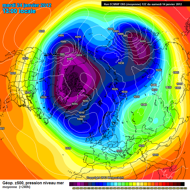
ECM mean.
http://www.meteociel...H1-240.GIF?14-0
Im becoming increasingly confident of the outlook now. Simple summary is turning colder next weekend with snowfall possible in some areas. Thereafter remaining cold especially towards the SE but Ireland/NW may turn slightly less cold. Going even further the combination of blocking remainiing to the NE, trough into Europe, PV to the W of Greenland means further undercutting is possible which may lead towards an E,ly developing.
Thanks, Dave.
In a rare post here I'd like to agree with your astute observations which confirm the trends my untrained mind had identified.
Regards,
Mike.
P.S. Very belated Happy New year greetings.
-
And yet.....
..so, who knows? God alone, probably!
Regards,
Mike.
-
UK forecast - Day 16 to 30
UK Outlook for Thursday 19 Jan 2012 to Thursday 2 Feb 2012:
Remaining fairly unsettled in the north at first, with spells of wind and rain, interspersed by brighter but colder conditions with showers, wintry over high ground in particular. Further south, somewhat quieter conditions look more likely, with less in the way of rain. Towards the end of January, high pressure may become more influential, resulting in drier and probably brighter conditions becoming more prevalent across the country. Temperatures for many areas will initially be around or slightly above average, with a trend to slightly colder conditions towards the end of the month, bringing an increased risk of overnight frost and perhaps some fog.
Issued at: 0252 on Wed 4 Jan 2012
Yes, it's interesting that the Meto didn't issue this until a couple of hours after the day 6 -15 forecast. It's as if they had things to ponder. Or am I just being a conspiracy theorist?
Regards,
Mike.
-
-
Him, everyone using conventional methods and even me as an art historian looking at the pressure charts can see that one coming at 1-2 days out!
Too true, CR.
''A painting is a hypothesis which we test by looking at.''
E.H. Gombrich ( International Herald Tribune August 1991)
I suppose us art historians can test Piers' hypotheses in the same way, but unlike looking at, say, Rembrandt, we can have a bloody good laugh - all too rare in this line of work (art history, that is!). Thanks and a tip of the hat to the late, great Ernie!
Best wishes,
Mike.
P.S. Happy New Year Piers - I bet you didn't predict you'd get that from me! I wonder if he ever reads these threads?


Another 6th sense?
in Space, Science & nature
Posted
Here's an interesting read....
http://www.psychologytoday.com/articles/200007/is-there-sixth-sense
Personally, I'm in the 'yes there is' camp for a number of reasons, but that would mean me rambling on so I'll spare you! (Bet you didn't see that coming!)
Kind regards,
Mike