


Muffelchen
-
Posts
845 -
Joined
-
Last visited
Content Type
Forums
Blogs
Gallery
Events
Learn About Weather and Meteorology
Community guides
Everything posted by Muffelchen
-
Yep, I think the main action is over for today, ezcept for some nice lightning shots later. Was thinking of going to bed: may give it another 10 minutes or so......here's hoping
-
Cells now firing all the way to Frederick Co. OK.
-
AArrrggghhh, won't load for me :-(
-
Cell to the NE of the Haskell cell, which is definately moving due South(!), near Seymour is now seriously getting its act together. This one is also worth watching.
-
Knox Ciity storm is a monster! Seems to be a line of storms going off to its north now. Is this the Cold Front? Edit: KC storm has TVS on it now.

-
Knox City storm is a right-mover and has TN reported on it now. Edit: sorry about poor image!
-
Anyone know if the team are on Spotter Network? If so, anyone know their callsign? That way I could see thier position on Google Maps or online.
-
Knox City storm taking on classic 'eagle wing' shape on radar and a wall cloud has been reported on it. Anyone know exactly where the team are? Edit: cell now Tornado Warned
-
New cell appeasr to be gping up SW of the Knox City storm, near Aspermont.
-

Chase 2009 Day 4 Discussion - Tx Panhandle
Muffelchen replied to Paul Sherman's topic in Storm Chase USA
Funnel cloudd DD of TVN now! Edit: Tornado -
Snow Watch: East Mids, Lincs And S & E Yorkshire
Muffelchen replied to grab my graupel's topic in Spring Weather Discussion
Just rain here: seems to be a lot of this this winter: just look at my snow days -
Snow Watch: East Mids, Lincs And S & E Yorkshire
Muffelchen replied to grab my graupel's topic in Spring Weather Discussion
Pretty much stopped here now with about 3 cm lying, however, snow is very wet and is melting. Perhaps a frost if the skies clear? -
Snow Watch: East Mids, Lincs And S & E Yorkshire
Muffelchen replied to grab my graupel's topic in Spring Weather Discussion
Very light but persistant snow (snizzle) on the wind here, but the sun is shining. Can't complain. There are heavier clouds to the north though...... -
Snow Watch: East Mids, Lincs And S & E Yorks Pt 2
Muffelchen replied to pottyprof's topic in Spring Weather Discussion
Sleety rain here now, had been rain earlier and it is very heavy. In danger of carping on but forecast on Radio 5 at 21:00 said more heavy snow for the the North East and the Pennines. Not just the Pennines: I knew I had heard that right on the radio this afternoon, if they are still persisting with this this late in the evening. The BBC is all hype! Mods: wrong forum should be in snow watch E Midlands, Lincs etc. Please move, thanks :-) -
Snow Watch: East Mids, Lincs And S & E Yorks Pt 2
Muffelchen replied to pottyprof's topic in Spring Weather Discussion
In view of the fact that it is due to get colder again, with the departure of the mild sector and the snow down South, is there any chance it will turn back to snow again or are all of us in Hull, Grimsby and Langtoft (which is quite high up and well North of here) get any more snow? I was working today - first day of new job - but was hoping another good dump overnight as the Beeb were forecasting for here only a couple of hours ago, would mean a day off for me. here's hoping..... -
Snow Watch: East Mids, Lincs And S & E Yorks Pt 2
Muffelchen replied to pottyprof's topic in Spring Weather Discussion
Ditto! Are Beeb wrong then? I guess they must be but this was only 2 hours ago. I simply don't get it. -
Snow Watch: East Mids, Lincs And S & E Yorks Pt 2
Muffelchen replied to pottyprof's topic in Spring Weather Discussion
Mild sector was forecast by the models... Hence the blue over your area. Yes but a couple of days ago it was definately saying it was going to stay South of the M4, what happened? Anyway, looking at the map you posted, I do not see where the 40 cm the BBC are talking about at Ainley Top is coming from as it shows only sleet in Huddersfield. Are the Beeb simply wrong? They have sent their local (Hull) minor celebrity weatherman, Paul Hudson, there to witness the event! I love weather but sometimes I am left completely flummoxed and this is one of those times. Paul Hudson was on Radio 4 at about 17:30...only a couple of hours ago. Tony -
Snow Watch: East Mids, Lincs And S & E Yorks Pt 2
Muffelchen replied to pottyprof's topic in Spring Weather Discussion
Heavy, rainy sleet here now. I really don't get this at all. I haven't seen a chart today but I thought that this cold spell was nailed on for a few days yet. All the way home from Skipton the radio is reporting another 8 inches or so and, when I get home, it is thawing :lol: Explanations would be most welcome as any warm sector was supposed to stay South of the M4 corridor and, following models runs last night, in France. Why is in 2 degrees and almost raining then? I can't figure out whay this has happened. In fact I often wonder why forecasts do not pan out yet there is NEVER an explanation on the BEEB or even here in reality. Perhaps a forecast follow-up discussion explaining what happened that wasn't predicted would be a good thing on here. Any takers? -
Snow Watch: East Mids, Lincs And S & E Yorks Pt 2
Muffelchen replied to pottyprof's topic in Spring Weather Discussion
You betcha. Ten miles West, just before Market Weighton. -
Snow Watch: East Mids, Lincs And S & E Yorks Pt 2
Muffelchen replied to pottyprof's topic in Spring Weather Discussion
I have just driven home from Skipton and Arras Hill on the A1079 is about the best, plus it's not too far! 3 foot drifts you have to drive around... -
Snow Watch: East Mids, Lincs And S & E Yorks Pt 2
Muffelchen replied to pottyprof's topic in Spring Weather Discussion
Nothing in Bev at the mo and quiet for the last couple of hours. Avout 2cm on the ground so far.... -
Started snowing here about 04:30 this morning (4th December) and has continued up to and including now. Snow is VERY wet but has been sticking a bit and there is about an inch of slushy stuff about where it has fallen on grass/roads etc. Where it has fallen on the remainders of Tuesdays snowfall it is about the same depth but not slushy, just really slippery. Temperature is 1C at the moment and has been holding steady all morning. There was a heavier spell of snow for about half an hour at 07:30 this morning that was responsible for much of the slush. All in all wintry, but very unpleasant at the moment. Muff.
-
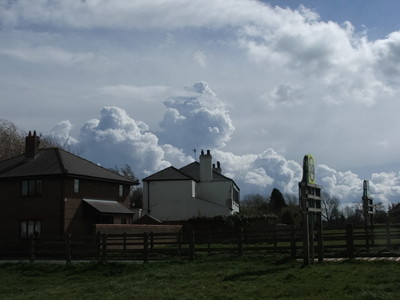 Cumulus congestus clouds building in a very unstable atmosphere. Picture taken at 12:10 GMT on 11th April 2008
© © K A Sheehan
-
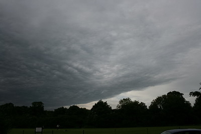 This sinister cloud appeared ahead of a thunderstorm with a very active, rolling gust front. This cloud appeared ahead of the gust front and moved from left to right in the picture (SW to NE). Unsure of exactly what this is but I think it is the base of the anvil although, like a pseudo-front, it drops down into the storm. Picture was taken at 20:00 on 7th July 2008
© © K A Sheehan
-
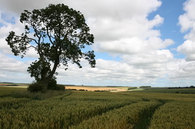 Cloud streets in a northerly wind in East Yorkshire. Picture taken looking North at 15:00 on 15th July 2008
© © K A Sheehan


