


johnholmes
-
Posts
22,972 -
Joined
-
Last visited
-
Days Won
84
Content Type
Forums
Blogs
Gallery
Events
Learn About Weather and Meteorology
Community guides
Posts posted by johnholmes
-
-
Dry, mostly sunny with patchy cloud, a low of 4.5 C; lovely change from yesterday with 24.0 mm of rain, mostly before lunch time.
-
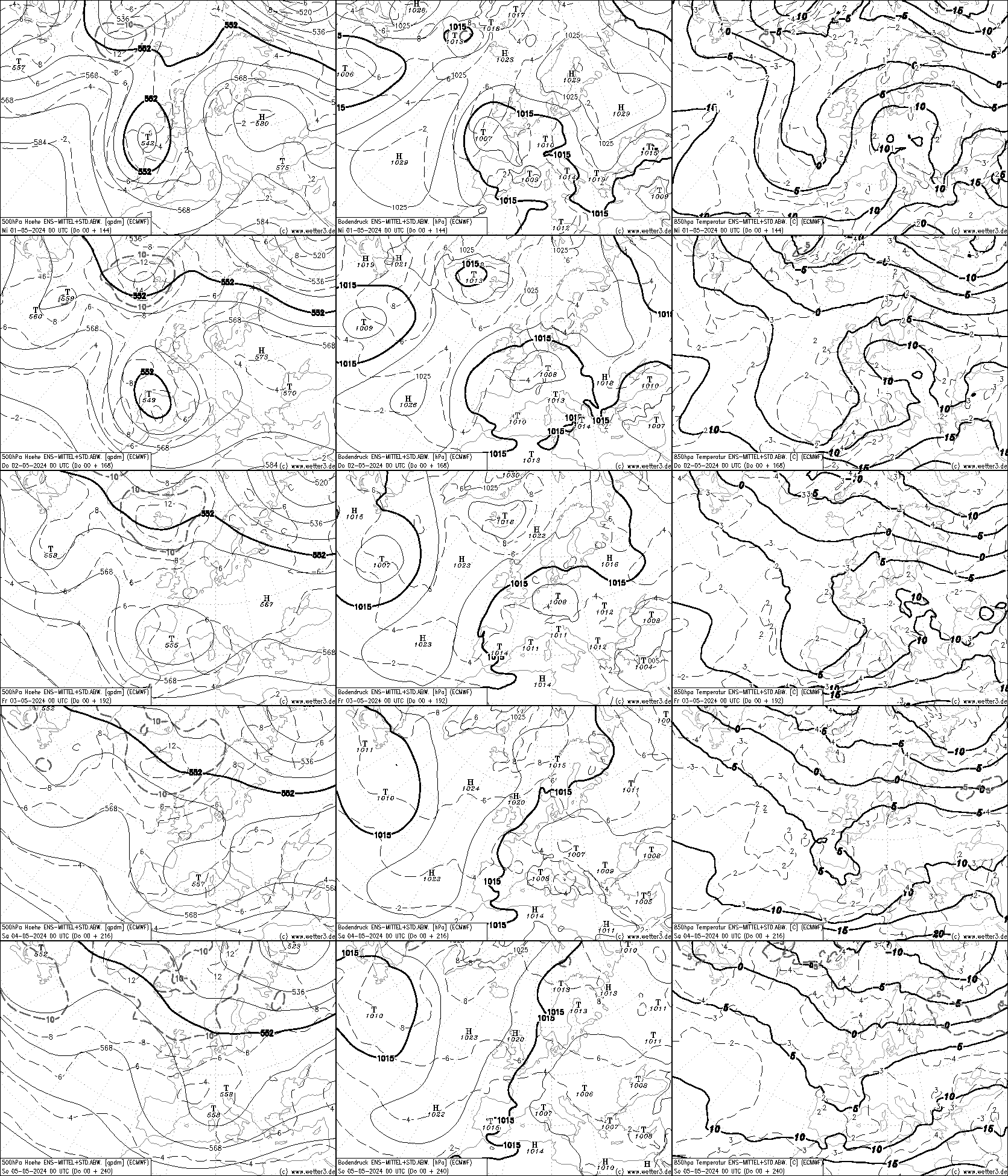
A look at the 500 mb predictions
THREE weeks since last did in depth check!!
Sunday 28 April
NOAA first then ECMWF
Well at long last little signal for Upper ridging CLOSE to the UK but still very much in evidence in polar regions. Small +ve showing where the major winter trough usually resides (ne Canada/sw Greenland. Very slack flow into the far northern UK from s of west whilst almost nil for the major part of the UK. Main signal for contour troughing is around 40W and 40 N; (the remains of the major winter troughing perhaps?). By the 8-14 and the chart, to me, shows what we should expect for mid spring from the far west across into Europe? A very small +ve anomaly showing over nw Iberia.
Turning to the ECMWF output for much the same 6-10 day NOAA set of charts, actually 4-8 May,
It starts with the ridge just ne of Scotland extending sw with troughing still showing over ne Europe. During the period the 500 flow becomes a more general westerly over the approaches and the UK itself into Europe with the trough moving east with it showing north of the Black Sea and Turkey by the 8th May.
So pretty similar really to the flow at 500 shown on the NOAA outputs. Not exact of course but one could say about on the same pages!
As they are fairly similar, and from occasional peeps over the last few days, the pattern seems to have evolved fairly sequentially, I would imagine the upper flow will not be too different in the 6-10 period and beyond.
This is likely to see, at least, a decrease in what seems like the UK’s own monsoon season for many to a, not completely, but drier interval. Also with some local variations (sorry East coast effects at times), somewhat more seasonal temperature values than the late January sample many have had recently. As to any specifics then possibly still more ppn for southern parts at times but I feel the ppn will be more likely to affect other areas also. Whether thundery developments develop is beyond this brief peer into what may happen.
Good luck, sometimes this use of 500 MB flows does give a good idea of the next 2 weeks at that height but minor day to day variations can and do play havoc with attempts at predicting what the bottom 18,000 ft of the atmosphere can turn up!

Original post: https://community.netweather.tv/topic/99814-model-output-discussion-spring-has-sprung/?do=findComment&comment=5062362 -
- Popular Post
- Popular Post
A look at the 500 mb predictions
THREE weeks since last did in depth check!!
Sunday 28 April
NOAA first then ECMWF
Well at long last little signal for Upper ridging CLOSE to the UK but still very much in evidence in polar regions. Small +ve showing where the major winter trough usually resides (ne Canada/sw Greenland. Very slack flow into the far northern UK from s of west whilst almost nil for the major part of the UK. Main signal for contour troughing is around 40W and 40 N; (the remains of the major winter troughing perhaps?). By the 8-14 and the chart, to me, shows what we should expect for mid spring from the far west across into Europe? A very small +ve anomaly showing over nw Iberia.
Turning to the ECMWF output for much the same 6-10 day NOAA set of charts, actually 4-8 May,
It starts with the ridge just ne of Scotland extending sw with troughing still showing over ne Europe. During the period the 500 flow becomes a more general westerly over the approaches and the UK itself into Europe with the trough moving east with it showing north of the Black Sea and Turkey by the 8th May.
So pretty similar really to the flow at 500 shown on the NOAA outputs. Not exact of course but one could say about on the same pages!
As they are fairly similar, and from occasional peeps over the last few days, the pattern seems to have evolved fairly sequentially, I would imagine the upper flow will not be too different in the 6-10 period and beyond.
This is likely to see, at least, a decrease in what seems like the UK’s own monsoon season for many to a, not completely, but drier interval. Also with some local variations (sorry East coast effects at times), somewhat more seasonal temperature values than the late January sample many have had recently. As to any specifics then possibly still more ppn for southern parts at times but I feel the ppn will be more likely to affect other areas also. Whether thundery developments develop is beyond this brief peer into what may happen.
Good luck, sometimes this use of 500 MB flows does give a good idea of the next 2 weeks at that height but minor day to day variations can and do play havoc with attempts at predicting what the bottom 18,000 ft of the atmosphere can turn up!
-
 21
21
-
 2
2
-
 3
3
-
I'll try and find the time to have a longer look at my usual charts and post later today.
-
6
-
1
-
-
A wet start with rain, moderate at times, 9.0 mm since it started sometime after midnight; lowest temperature=5.4 C
-
Dry with patchy cloud and a white ground frost; lowest temperature=0.8 C, the lowest this month
-
A lot of cloud but bright spells; slight rain shower 0500=0.2mm of rain; lowest temperature
=2.3 C in the early hours
-
Cloudy and dry with a low of 4.2 C
I wonder if I might get a 'dry' day today, so far only 4 this month!
58.6 mm so far which is approaching twice my average
-
-
Cloudy and dry with a low of 5.2 C
-
Overcast with ocnl light rain; 2.0 mm since midnight; a low currently of 5.2 C
-
A dry sunny start with a low of 4.6 C
-
Dry with a lot of cloud but also some sunshine at times, mild with a low of 9.8 C; starting to get a bit breezy
-
A sunny start with a white ground frost and a low of 1.2 C (the first ground frost for over a month), rain on the way by about lunch time looking at the radar.
-
Overcast with ocnl rain, 2.0 mm since midnight, also rather breezy overnight a max of 23 mph,
current low is 7.9 C
Update to cover for the weather on the trough/front, brief heavy rain with T falling to 4.8 C now up to 6.2 C with rainfall on 6.8 mm; more rain upwind looking at the radar and quite breezy
-
Dry and mostly sunny to start Sunday, a low of 6.6C
-
Dry and motsly cloudy with another mild start with a low of 9.4 C
-
Dry and mostly cloudy with patchy Sc and a lot of upper layers; a low of 10.9 C, so another mild start
-
Dry cloudy and mild here with a low of 12.7 C, approx 7C above the average minimum for this time in April
-
Cloudy with no rain since midnight; after a wet late evening; a low of 7.1 C
-
The 6-10 day 500 mb anomaly chart from NOAA shows a fairly marked Confluent ridge leading into a Diffluent trough off the coast of n America. This can lead to the development of a surface low, possibly rapid deepening. So at some stage in this time scale we could expect a fairly deep surface low to form in that area. The flow is then shown as SW'ly fairly strong at 500 mb. So a rather unsettled outlook in the 6-10 day period seems quite likely
Original post: https://community.netweather.tv/topic/99814-model-output-discussion-spring-has-sprung/?do=findComment&comment=5052951-
2
-
-
Dry and cloudy with a mild low of 10.3 C
-
For what it is worth ECMEF seem currently to be going with the rather colder but brief version
-
4
-
1
-
-
Well the blue sky did not last long; as the radar shows a fairly active line of showers now moving through with a dry slot following, hopefully with some sun, quite breezy also T=11.5 C, down on this time yesterday, as is the Td.


Daily weather observations - April 29th to May 5th
in Spring Weather Discussion
Posted
Dry with a bit of cloud but mostly sunny with a low of 7.7 C