


cookie27
-
Posts
170 -
Joined
-
Last visited
Content Type
Forums
Blogs
Gallery
Events
Learn About Weather and Meteorology
Community guides
Posts posted by cookie27
-
-
Met Office are on SkyNews at 8.20am might be worth a watch
-
 1
1
-
-
Highest winds around 130km/80mph at the moment on the northern back edge. Let's see where that makes landfall
-
102km latest gust at Sherkin Island just reported...
-
 1
1
-
1
-
-
3 minutes ago, Nick F said:
18z GFS seems to have shunted strongest gusts a little further south, more of an elongated double centre of the depression, with a wave the northern centre deeper than the southern, but still tight enough gradient on southern flank of the low to bring damaging winds to southern England.

Does this bring the snow risk much further south too???
-
I do feel the Met Office are really praying this weakens as it crosses the country, but I've a feeling is moving to fast to do that and will maintain is power all way. And all the models suggesting their wrong too
I'm forecast max gust of 67mph on Meto website. I can see them having egg on their face come the 6 o'clock news tomorrow
-
2
-
-
4 minutes ago, damianslaw said:
I'm wondering where the TV reporters have decided to set up camp this evening. Somewhere on the coast of N Cornwall or N Devon and somewhere South Wales I imagine...
I was just thinking the same....most likely Bude, Cardiff, Swansea and Bristol...then London gets devastated and no one there lol
-
1
-
1
-
-
Pressure at the PAP Buoy had steady the past few hours at 995mb. Not sure how far Eunice is from it or if past it now and deepening nearer.
K1 Buoy is dropping at about 3mb an hour now at 1002mb...
-
11 minutes ago, Wingman Blue said:
How has ‘the landscape of England changed dramatically over the last 30 years? Where and how?!!
Firstly, there are over 30 buildings in London 150m or higher built since. And elsewhere in the country. Population is some 10m higher, more urban development, roads, rail, the list goes on. The country isn't the same exactly is it.
-
2
-
-
I know there has been a lot of comparisons made with 87 and Burns Day storms. But, it's worth remembering that the landscape of England had changed dramatically over the passed 30yrs and there winds don't need to be that strong to cause devastating scenarios like funneling, mini tornados, etc. Also the timing of this couldn't be any worse really, ground will be saturated due to recent rainfall. There are so many more variables to consider this time and probably the best advice is to stay as safe as you can.
-
4
-
-
24 minutes ago, Mark Smithy said:
Anyone?
Pap Observations
WWW.METOFFICE.GOV.UKPap 7 day weather forecast including weather warnings, temperature, rain, wind, visibility, humidity and UVhere you go
-
1 minute ago, philglossop said:
Having lived through the storms of 1987 and 1990 and remember both very clearly, I think this one is going to join it as being as memorable. I remember the Burns Day the damage it did here in Plymouth and South Hams and I like others expect a red warning here tomorrow morning unless we get a sudden downgrade.
Today is prep day!
I went out and brought loads of candles and make sure phone and tablet charged before Friday...oh and plenty of drink too lol
-
1
-
-
Is it just me or are Metoffice really underplaying this or do they know something we don't know. I'm now in Eltham South East London and these seem at least 10mph what we can expect

-
2 minutes ago, James Maidstone said:
These are max gusts from the whole of the storms evolution, so the 200kph is the storm passing through there SW of Ireland in the early hours of Friday and the associated gusts with it.
Ah ok get that, my french isn't very good lol
-
1 minute ago, weirpig said:
Yep very high winds open to change but England Wales anywhere will have disruption
I just saw this and did intrigue me greatly at that 200kph in the Atlantic...is that possible another low forming right behind Eunice or 'stingjet' that might be dragged across south england after Eunice.
-
I think what might turn out to be interesting is the amount of taller buildings we have since last major storm this south. Places like Shard must be expecting 100mph winds at that high up, infact something like 11 buildings over 200m in London. Let's see if they were built to withstand this extreme event.
Also, wanted to add given the timing and strength it's certain Met Office will change the Amber to Red, I expect tomorrow morning. And might be a government warning advising people to stay indoors as this will be epic event by the looks of it.
Something the models aren't going for and considering that it's a rapidly declining low is that it further depends still after landfall and as it enters North Sea, but might pick this up once it's properly formed and track is tied down.
-
7 minutes ago, jamesgold said:
For a light blue on the radar, this is pretty good, big flakes
Nothing on the radar but snowing nicely here too
-
1
-
-
Just now, cookie27 said:
Nice dusting from the shower that just passed over.
-
2
-
-
Nice dusting from the shower that just passed over.
-
Interesting reports of lightning on the radar, wonder if its associated with the low in northern France, maybe pushing energy north.. Lets see what happens.
-
1
-
-
15 minutes ago, Daniel* said:
I think ECM 12z was drunk it forecast a min of -12C in Central London, Thursday morning which would be record breaking never seen such a cold forecast.
This would suggest a possible lot of snow between now and then.
-
2
-
-
Last few frames definitely seems to be ENE which would be fantastic for this night of streamer watching..,
-
4
-
1
-
-
Something definitely stirring in Greenwich, light snow with odd bigger flake.
-
2
-
-
1 minute ago, snowbob said:
Ha ha
ive said that for two nights now
I've had my kip, so refreshed and ready for tonight's fun
-
3
-
-
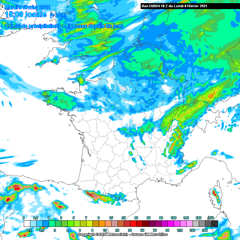
6 minutes ago, zubzero said:
For the Thames streamer crew the EURO4 shows one setting up from about midday tomorrow onwards
http://modeles14.meteociel.fr/modeles/euro4/runs/2021020818/euro4-45-20-0.png?08-23
That's accumulating snowfall, so looks like it could all be starting now and radar does suggest so.
-
3
-
1
-


Storm Eunice - 18th February
in Storms & Severe Weather
Posted
Think the MetO have turned off the reporting from buoys