


NorthNorfolkWeather
-
Posts
1,474 -
Joined
-
Last visited
-
Days Won
1
Content Type
Forums
Blogs
Gallery
Events
Learn About Weather and Meteorology
Community guides
Posts posted by NorthNorfolkWeather
-
-
Thanks.

I really couldn't see why the BBC were mentioning wintry flurries for this afternoon on their Friday forecasts given the forecast models.
I'm with you all the way on that, the Beeb seem to be about 12 hours behind in saying when snow will fall. This morning, when we were having the first of our showers, the forecaster on BBC News Channel was saying "No Snow till late in the day". Radar was showing showers!!
-
Here in North Norfolk, we have had some heavyish snow showers since 9.30 this morning giving a slight covering. Temps and dewpoints all over the shop. At 830 this am we had a temp of 2C, dewpoint of -6 and a strong wind. In the snow, temps dropped to 0.5C, dewpoint increased to -1C and the wind dropped slightly. Now we have a clearance, the temp is 1C, dewpoint -5C and the wind has increased again!
And looking at the Radar, we will not have much more for a couple of hours at least, the wind is really biting now
-
Fine with unbroken sunshine here at the moment.
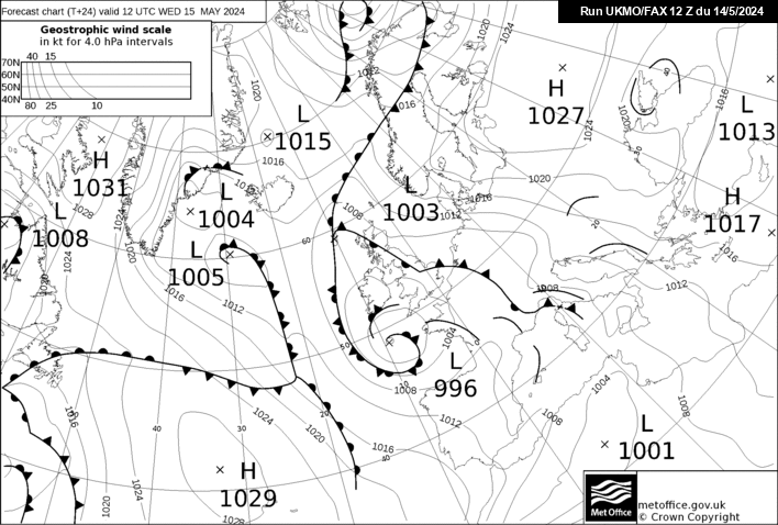
New T+24 FAX chart: http://www.meteociel.fr/ukmo/fax/fax24s.gif
Isn't that low quite a bit further south? And more in the way of short waves?
-
And 850 Temps of -10 across the Norfolk/Suffolk coast at 09:35
-
Current Extra Radar timed at 09:00.
-
This looks promising, I wish I understood the words better.
http://www.teleweer.nl/portal2.asp?url=/we...ten/buienradar/
No one but the Dutch understand Dutch
That's their expected run, so I'll be happy
-
Apart from the usual orange level 'be prepared' alert for the area from the MetO = snow
There's this at the end: "During Tuesday, snow is likely to turn to rain from the east, except over higher ground."
My location is 110 metres asl extreme west of Suffolk (about 60 miles inland from coast).
Does 110m count as higher ground? Clutching at straws, I know, but I can hope
Nope, don't think 110 Metres will calss as high ground, I'm 60 miles North of you but slightly lower 45 Metres, so the distance North will almost certainly not help. If the triple point is 50 miles east, we'll be under a LOT of snow, otherwise we'll get something to start with, but it may not last
-
Well, in truth even the models get it wrong at times. I'm only about 6 miles from the North Norfolk coast, so I need plenty of wind to drive the showers. Haven't had serious snow here since Jan 1987, then we were cut off for a week, I live in hope!!
As far as the models are concerned, I've noticed, on the rare occasions we have had easterly snow, it seems to start from about 04:00, so my guess is we'll get a dusting tomorrow during the day, starting some time after lunch and if we get anything serious, it will not happen until Monday, starting early
We Shall See
-
Clear Sunny, Frost on ground cold easterly Temp 1C
-
There's a very interesting article on the Warming of Western Antarctic in
http://wattsupwiththat.com/2009/01/21/anta...n-of-viewpoint/
There has been a switch in the way that it's been recorded with different baselines, i.e. satellite data as opposed to ground station data. Difference is "only" 20 years of data.
Note also that there are a string of volcano's on the Western side of Antarctia
Also, look at the second article on wattsupwiththat
http://wattsupwiththat.com/2009/01/22/anta...-in-antarctica/
Which is a brave man actually saying what many people feel.
-
The two prime examples of coupled warming at both 10 hPa and 30 hPa are January 2006 and January 1987. This warming is on course to beat both. Both were I think displacement SSWs so it is difficult to compare with this present one which is a vortex splitting SSW. And of course there are many other factors to take into consideration if and when a SSW reaches the troposphere.
c
What's the greatest warming that's been recorded? It seems to me that if this is a major SSW (and with the temperature increase I cannot see it being anything else) there will be "Somewhere" experiencing record cold in the next 10-15 days. They have aleady have some record lows in the US this year (Maine and Illinios) could this take them even lower?
What are the odds of China suffering similar problems as last year with lots of disruption due to snowfall, perhaps the difference will be that the problems will be at the end of the holiday for new year, not at the beginning
-
-0.3c
I will continue to predict what i would like to see in the sad hope that somehow it will help.
I'll go for lower than that for the month, if the SSW carries on, we may have a -1 or less


Snow Watch: London, Ea & Se England
in Spring Weather Discussion
Posted · Edited by NorthNorfolkWeather
Countryfile weather was interesting, North Norfolk will not do too well, London looks as though it could do really well
What I liked was the "This will be a severe event, maybe even an extreme event"
Now is that hype or truth? The BBC have a very fine line to tread