


Ben_Cambs
-
Posts
2,457 -
Joined
Content Type
Forums
Blogs
Gallery
Events
Learn About Weather and Meteorology
Community guides
Posts posted by Ben_Cambs
-
-
The centre of the low is over Middlesborough as of 16.20, you can see the wraparound (northerles) just to the west of the city. Here in west Norfolk had about 5cm but easing off now. Got thesnow magnet powered up for later though

Hi and welcome to the forum!
-
Hi all, hope you had a good day.
So after this morning's snow which gave about an inch, it remained largely cloudy with an odd sunny break, until around 12:30pm. Some heavy snow at times this afternoon though was falling on wet surfaces. Perhaps 3-4cm on the grass, but looking lovely and wintry. Hopefully dew points should start to fall soon, with the chance of more snow a bit later on, I would of thought. Could be icy in the morning.
-
Good luck to everyone today! Probably won't be able to come on again until the late afternoon (or later than that if conditions are bad!
). Still snowing lightly here. -
Morning all, nice covering here too and snowing lightly, a bit more to come too! Hopefully a taster for later on today.
-
Going to call it a night - could do with a good night's sleep! Nice NAE 18z and GFS 18z. See you all in the morning!
-
met office said there was meant to be snow now and there is none so there wont be any typical
The main band is coming during the course of tomorrow.
-
This latest Met office press release worth a read:
http://www.metoffice.gov.uk/news/releases/archive/2013/ice-and-snow-continue
-
Expecting amber warnings to be issued for most in the region by the Met office later for tomorrow, would be very suprised if they didn't.
-
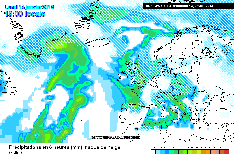
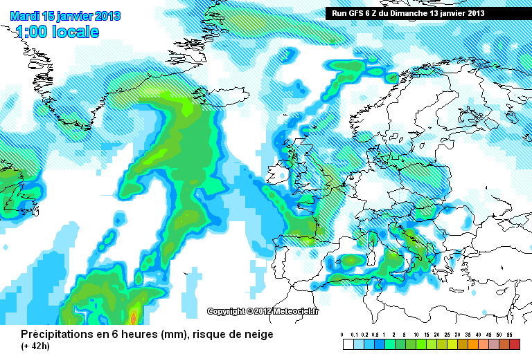
GFS 06z update: better for our region for tomorrow with the mild sector further west!
http://modeles.meteo.../gfs-2-30.png?6
http://modeles.meteo.../gfs-2-36.png?6
http://modeles.meteo.../gfs-2-42.png?6
Will wait for GFS 0.5 to update to confirm..
-
Morning all. Somehow I'm up this early (on a Sunday!) so an update on the models for tomorrow.
NAE:
First band of snow arriving around 6am:
Weakening as it travels east. NAE predicting only about 1-3mm of precipitation from this first band.
Second band of precipitation arriving during the early afternoon:
Second band delivers about 3-6mm of precipitation.
A look at the dew points from midday onwards. Need the DP to be 0C or below:
Looks OK for most of the region. Perhaps the risk of marginality towards the SW of the areas covered in this thread however this can and will change.
GFS appears to be a bit more marginal particularly late afternoon.
First band is fine as all snow:
http://91.121.16.5/modeles_gfs/runs/2013011300/30-574.GIF?13-0
http://91.121.16.5/modeles_gfs/runs/2013011300/33-574.GIF?13-0
However more marginal in the afternoon as the second band arrives, again more towards the SW of the region but the marginality on the GFS affects more of the region too on the 0z.
http://91.121.16.5/modeles_gfs/runs/2013011300/36-574.GIF?13-0
http://91.121.16.5/modeles_gfs/runs/2013011300/39-574.GIF?13-0
Partly down to this milder wedge of air mid-afternoon, travelling south-east.
http://91.121.16.5/modeles_gfs/runs/2013011300/36-7.GIF?13-0
http://91.121.16.5/modeles_gfs/runs/2013011300/39-7.GIF?13-0
As for the UKMO and ECM models regarding Monday and the 850hPa temperature, UKMO would look fine to me and ECM it's difficult to say because of the 24 hour period between charts, but has -6 850hPa over the whole region between 1am Monday morning and 1am Tuesday morning, admittidly not too sure where the mild sector is on this run, but looks OK to me.
Met office forecast for east of England for tonight and Monday:
Tonight:
Staying very cold. Gradually clouding over with snow spreading from the northwest to all parts. This will lead to some accumulations, especially later, also some very icy conditions. Minimum temperature -3 °C.
Monday:
Cloudy and very cold, the early snow clearing for a time, but then further snow arriving during the afternoon. Some accumulations and remaining icy in places. Maximum temperature 1 °C.
Updated: 0319 on Sun 13 Jan 2013
FAX's will be interesting this morning to see where they place the mild sector (last night's didn't have it near this region).
Also for further interest, 3-5 day outlook for the east of England:
Outlook for Tuesday to Thursday:
Tuesday, very cold, bright or sunny intervals and snow showers, some possibly heavy near coasts. Wednesday and Thursday, very cold with a biting northeasterly wind and heavy snow showers.
Updated: 0319 on Sun 13 Jan 2013
All to play for.
A more general model update shows the cold spell lasting untl the end of the weekend at the earliest, so more snow potential and cold- v.cold conditions over the next week I would of thought.
-
See you all in the morning! Will try to do a morning model update if I'm up early enough (might be a struggle considering it's a Sunday tomorrow lol). As has been mentioned, snow showers possible tomorrow across Norfolk, Suffolk and Essex.
-
Just like to say good luck to everyone on this thread for next week! Hopefully it will deliver for everyone.
-
Well tonight's FAX's look great for our region! The mild sector should be less of an issue for EA + 3 counties. Do expect changes though in the models tomorrow, however I'm confident at the moment that Monday will deliver a snowfall.
-
Norfolk??
Norfolk will be fine!
-
Evening all, hope you had a good day.
Tried to keep up with the latest developments, though sadly came across 'this winter is terrible' posts in the MOD. Unfortunately my phone isn't good enough to sign in and keep up with this thread!
Thanks to John Pike for the update. Monday isn't set in stone, it will come down to radar watching and now-casting. Don't forget, the models don't control the weather..
-
I'm noticing the fact that the GFS is putting any breakdown further and further back.
But anyway, still looks fine for Monday's, into Tuesday's snow on the 0z.
-
hi ben have updated already
96 and 120
they are on prev page
Haha oh dear, my apologies, somehow missed them! Shall take a look at them!
-
hi ben
check my fax updates
they are on here
Hi John, sorry I was referring to the updated FAX's (T+96 and T+120)
-
Ironic Ben, Upgrade then tomorrow. lol
Hi Jason, hope you are well.
Wonder if the other models will begin to pick up on this second shortwave tomorrow. Unless I'm mistaken only GFS is picking up on this second shortwave on Tuesday, interesting to see the model output tomorrow and if they begin to pick up on this feature!
-
Latest GFS shows three snowfalls, Monday, Tuesday & Wednesday, with Snow showers on the way from the North Sea. Could be special early next week!
Yes Wednesday could also provide heavy, penetrating snow showers from the North Sea!
http://modeles.meteociel.fr/modeles/gfs/runs/2013011118/gfs-0-120.png?18
-
hi ben
cannot wait for tues fax
funny thing that will not be forecast by tv until tomorrow
Hi John,
Yes it could be a very tasty chart!
Please keep up the FAX updates, I enjoy reading them as I'm sure many others do too!
-
Monday's and overnight into Tuesday's snow on 18z:
http://modeles.meteociel.fr/modeles/gfs/runs/2013011118/gfs-2-66.png?18
http://modeles.meteociel.fr/modeles/gfs/runs/2013011118/gfs-2-72.png?18
http://modeles.meteociel.fr/modeles/gfs/runs/2013011118/gfs-2-78.png?18
Then a shortwave delivers a second band of snow later on Tuesday:
http://modeles.meteociel.fr/modeles/gfs/runs/2013011118/gfs-2-96.png?18
http://modeles.meteociel.fr/modeles/gfs/runs/2013011118/gfs-2-102.png?18
http://modeles.meteociel.fr/modeles/gfs/runs/2013011118/gfs-2-108.png?18
-
GFS 18z looks similar to 12z in regards to Monday/Monday night/Tuesday. Interestingly, the shortwave that appeared on the 12z which could potentially deliver a second band of snow on Tuesday is on the 18z aswell.
-
Losing the plot here! So what has happened to the snow tomorrow? Or could it be one of those surprise days when we get dumped on
So basically we might get a few snow flurries over the weekend but the main event is on monday late afternoon ,is that right,plz can anybody enlighten me
Here's an amended post similar to one I made this morning.
Snow possible for areas south of the M4 corridor tomorrow, with a light covering in places. Snow showers on Sunday in Norfolk, Suffolk, Essex and maybe Kent, some showers pushing inland at times too. Monday into Tuesday could provide a significant fall of snow for the vast majority in this region. Snow potential continues thereafter, cold - v.cold conditions continuing with sharp frosts overnight.


 ). Still snowing lightly here.
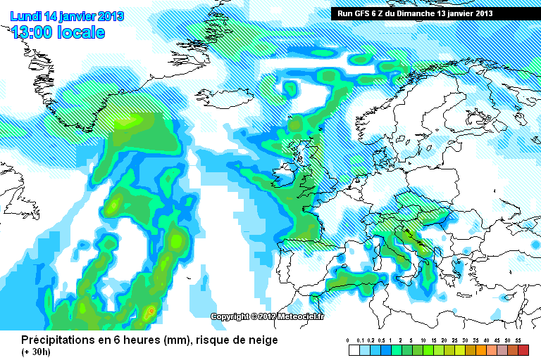
Three Counties & East Anglia Regional Discussion - January 14th 2013>
in Regional
Posted
Going off GFS 0.5 and NAE, dew points should start dropping off within the next couple of hours.