
- Popular Post


Nick F
-
Posts
9,900 -
Joined
-
Days Won
18
Content Type
Forums
Blogs
Gallery
Events
Learn About Weather and Meteorology
Community guides
Posts posted by Nick F
-
-
Certainly is quite the signal for high latitude ridging across Svabard and to the N Pole on the 12z EPS continuing day 10 onwards, whether it would be enough to suppress Atlantic troughing remains to be seen.
-
 3
3
-
-
8 minutes ago, bluearmy said:
At day 5 it disrupts se which means that the front that got to the east of the meridian by day 6 on the 00z run has now evaporated in the Irish Sea at the same time on this run
I would have thought that whatever is modelled to follow re split flow is questionable given this change ??
True, some weak disruption, but I was referring more to early next where previous runs both EC and GFS had shown the main thrust SE of troughing from the TPV at the weekend disrupting into a cut-off low and then being the trigger for an easterly that some had been hoping for, if the low went far enough in across mainland Europe, but this seems off the table now, but still time for it to come back if the models are mis-handling or missing further trough disruption beyond day 5.
-
1
-
-
5 minutes ago, northwestsnow said:
EC snow charts show quite a snowy NW Britain
")
only really upland areas as far as I can see on the 12z EC, though obviously that may lower / change.
EC snow at t+162
Seems to be a winter of looking to the NW for cold and maybe we may have to look out for the sliders again if the Pm pattern sets in ...
-
5
-
-
12z EC op a change from the 00z run in that it doesn't disrupt the Atlantic trough into a cut-off low and keeps it intact and thus lifts it NE, this likely because less amplification working downstream from N America and blocking too weak / too far east to disrupt the trough ... a step towards recent GFS ops which has had this trough intact idea. Again the EC maybe too amplified and has backtracked to GFS, but trough disruption early next week may still happen, given the timeframe.
Cold Pm airflow always looked a better bet to get cold and wintry potential back than an easterly anyway ... as the source is colder.
-
4
-
-
- Popular Post
- Popular Post
Certainly would put low confidence in the model guidance past the weekend, given the disparity between GFS and ECMWF on what happens to the lobe / trough of the tropospheric PV extending SE towards NW Europe by the weekend. The models have been jumping between disrupting the trough into a cut-off low or keeping it intact and moving it gradually NE, as per GFS.
It’s nothing new the models having problems with trough disruption and not just in winter. 2PVU pressure charts clearly show cyclonic wave breaking near the tropopause across western Europe as the jet dives SE into SW Europe/N Africa, however, the models could be struggling with the energy transport poleward on the eastern side of the wave break and thus modelling the block over eastern or NE Europe. Stronger block and the troughing digging SE over NW/W Europe more likely to disrupt, weaker block and the trough more likely to remain intact and lift east or more likely NE.
Until the models resolve whether to keep the trough intact (as per recent GFS ops) or disrupt it (as per EC), then I don’t think anyone can be confident to whether an easterly maybe in the offing as the trough disrupts (deep cold easterly very much an outsider) or a polar maritime Wly / NWly regime takes over, or maybe the trough disrupts with low in situ over UK and filling and we get a north-south divide, with the north colder with risk of snow, south milder.
One thing to bear in mind if we do get a slack easterly or southeasterly flow, not the deep cold/convective type, is that 850mb temps can be misleading when they look ‘warm’, with an inversion often occurring at this time of year, with the surface colder than aloft, especially where cloud breaks occur to allow nocturnal radiative cooling, which in a dry continental flow allow temperatures to fall, with any subsequent cloud cover up keeping temperatures supressed than even the models indicate.
In the broader picture of the upper flow patterns of the northern hemisphere, quite interesting to see +ve height anomalies over the arctic from the wave activity with poleward ridging form Alaska and also NE Europe. This could have ramifications for later in the month. The ens AO forecasts certainly staying in the slightly –ve territory.
I think some sitting on the fence required and a brave person who thinks either GFS or EC’s differing outcomes are more likely.
-
13
-
- Popular Post
- Popular Post
Morning, not the amplification over the Atlantic (as I mentioned in my diagrams last night) on the ECM this morning to get the upper trough / vortex lobe digging SE toward Europe to get it to disrupt into a cut-off low, instead the trough stays 'intact' and pushes NE, as a big weighting of the clusters showed on the 12z EPS last night.
However, I'm a bit sceptical that the 00z EC is showing a strong Scandi block at t+168:
... then blasting it away so easily by t+216?!!
There's still decent potential for the trough to disrupt into a cut-off low, ideally over mainland Europe rather than UK (as per GFS).
The day 10 GEFS stamps shows this possible, even tentatively in the means with the 'pinching' of the trough extension over Atlantic and over Norwegian Sea/eastern Greenland from Scandi block
-
13
-
 1
1
-
- Popular Post
- Popular Post
The models have shown that the Atlantic is really struggling to get past the Meridian next week against the block over Scandinavia, with the upper troughs pushing east across the Atlantic from the TPV over NE Canada disrupting and weakening as they hit the block to the east and a slack surface pressure gradient developing across the UK from mid-week. Some fragmenting /weakening rain pushing erratically east Wednesday, then becoming dry again Thursday and Friday.
A more asserted attempt next weekend from the Atlantic, as another lobe / upper trough from the TPV over Canada pushes SE from S tip of Greenland towards NW Europe. But this stronger surge from the NW could be a good thing. A weakening trough moving in off the Atlantic will just mean stalemate and no-man's land slack and boring nothingness, but a trough dropping SE into mainland Europe could be the trigger we need to change the stalemate.
IMO, as often the case, it's best look at the bigger picture, i.e. changes in wave patterns upstream over NE Pacific and N America to get an idea how this could favour a better outcome for us in UK/Ireland with regards to getting a colder and potentially wintry pattern back on the table.
The trigger, as I mention above, will be upper trough digging SE across UK into Europe, we may have to endure some wet and windy weather for a few days, BUT, upstream, although EPO looks to go +ve and PNA -ve for a bit next week, a -EPO / +PNA looks to return next weekend, which will re-amplify a trough downstream over N America after its relaxation this coming week,
This will then serve to amplify the flow downstream over N Atlantic and allow the trough digging SE into Europe to disrupt into a cut-off low as per 12z EC at day 10, 12z GFS days 12-15 and now 18z GFS day 10.
12z EC northern hemisphere
... an similar with 12z GFS, though later on
IMO, not point wishing the Atlantic will die to the west, as it WONT help build the block further west to the N and NE and we stay in boring no-mans land, we need robust troughing to extend SE into Europe from Greenland area then disrupt into cut-off low over mainalnad Europe (not UK!). High risk and next weekend, early following week commencing 15th could be pivotal.
-
22
-
4
-
- Popular Post
- Popular Post
There's no point sugar coating any of the output this morning, although UKMO and GFS prolong the undercut of the block over NE Europe, the block is too far east to advect any decent cold our way to interact with Atlantic frontal systems and bring snow away from hills, more likely source for any snowfall would come from Polar maritime flow from the NW. The EPS and GEFS point to an extension / lobe of tropospheric PV over N Canada have increasing influence again on the weather over NW Europe, i.e. +NAO signal and this has been showing in the ENS for a while, despite what the now ridiculed EC op has shown earlier in the week.
Looking longer term, +EPO signal showing for a while in the ENS with low pressure/troughing over NE Pacific replacing the -EPO ridge that was a familiar feature through December, so the upper flow flattening out across N America, with deep cold over mid-west and Ern U.S. retreating back to Canada with time and the flow flatter over the N Atlantic as a result.
10-15 day mean 500mb heights from both GEFS and EPS indicate low heights anomaly over UK/Ireland - which indicates low pressure systems a plenty crossing the UK, but could contain some cold Pm shots, best we can hope for until the pattern changes.
The MJO is headed through the 'warmer phases' in next few weeks, i.e. the wave is too far west (Indian Ocean) to have an effect on providing poleward upper divergence and effect changes in upper flow over N Pacific, so the flow will remain zonal across the N PAC, N America and N Atlantic. However, the EC weeklies out last night did show a return of the -EPO later this month and we may see the MJO orbit back into colder phases later this month too.
But for now, think I will have a break from analysing the models in any great depth for cold and do more constructive things with my time, obviously keeping an eye on them, because I don't think the block over NE Europe will have much influence before it fades, more the Atlantic will. Hard to swallow, but that's life being at the windward end of a large ocean. Its seems that recent years (post 2011) that unless you live on the eastern side of the large continental landmasses of the Northern Hemisphere, being N America and Eurasia, the moderating effects of the warm oceans and the anomalously warm arctic will keep the cold away.
-
15
-
1
-
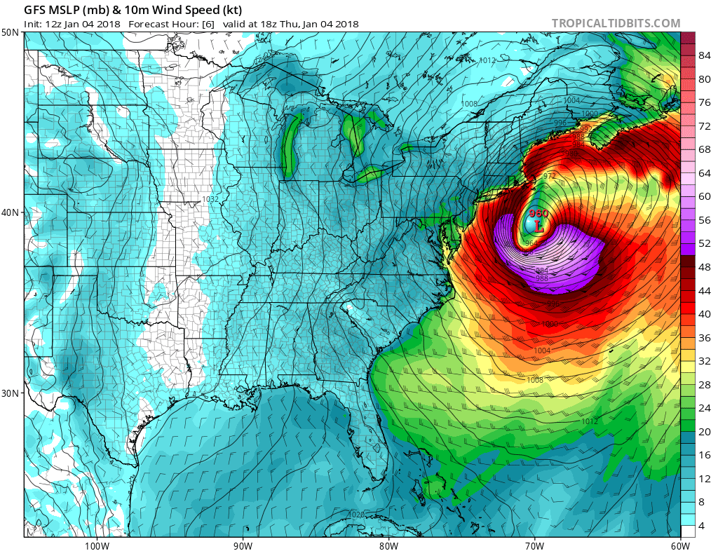
Winter Storm Grayson brought rare snow to Florida yesterday and, as it deepens today, will bring blizzards to Northeast U.S. Thursday-Thursday night
-
2
-
-
9 minutes ago, Man With Beard said:
Bit of a change in the clusters from yesterday - At D8, the Atlantic trough has made a little more headway against the NE heights. There's still considerable potential for a battleground Atlantic vs cold to the east if all falls correctly (wouldn't make judgements over how cold the weather from the east will be yet, as it's very easy to get a cold continent in early Jan. Well at least it should be!)
Ironically, the potential battleground could see colder air from the west compared to the east
-
6
-
-
- Popular Post
- Popular Post
At the outset of the models showing a weakening of zonality this weekend as the flow amplifies upstream to allow high pressure build close to the UK and even over Scandinavia for a bit, it looked like the high wouldn’t hold for too long before giving in to pressure imposed by the deep cold vortex to the NW.
However, the models, particularly ECM high res, has been toying with a stronger omega block developing to our NE over the last few days, this is still the case on the 00z operational, but the Scandinavia block is a few hundred miles further east on this mornings runs, which allows the Atlantic trough to gain more influence and introduce milder air.
I think the lack of seasonal snow cover / surface cold over northern mainland Europe is undermining the establishment of a block further west over Northern Europe, though there is enough cold air over Scandinavia to maintain a cold surface high and upper ridge here, but too far east to advect decent cold this way.
The crumbs of comfort I can find is that the Atlantic troughing is struggling to get past the meridian / 0 degree latitude on the 00z EC, and on GFS to a point, with much of the upper flow energy surging across the Atlantic going south into SW Europe on EC because of the block just to the NE. The downside is lack of cold air over near continent when Atlantic frontal systems encroach on the UK. Does feel like we are getting a bad deal, despite the promise shown of a block over Scandi and disrupting Atlantic, seeing snow falling in Florida and a snow storm hitting NE USA makes it even harder to swallow.
but given the background pattern of MJO heading into ‘warmer’ phases, the strong trop PV to the NW and strong jet over the Atlantic, return of the strat PV to its home over the pole, it could be worse. Some cold winter sunshine on Sunday and Monday too look forward too as high pressure settles nearby and holds back the relentless cloudy, wet, windy and mild weather we’ve endured this week.
-
10
-
16 minutes ago, lorenzo said:
Its poised on Ens and close up fluid dynamics until the US system bombs - that is as succint as I could say, the resulting nuances in either clustering or model consensus will not be readily resolved until the margins reduce.
The margins involved include the dissipation across our locale in the next 68 hrs of all the energy of the US system..
Yes, the rapidly bombing Winter Storm Grayson grazing the east coast of US will certainly be throwing a lot of energy our way over next few days and is one of the main catalysts for the high to build close to / over northern Britain this weekend before drifting east. How much energy it throws into the upper levels could determine how strong the block becomes, which may not be handled properly perhaps by the models - perhaps a GFS weakness there?
-
1
-
-
Quick comparison with updated t+120 fax vs 12z EC +UKMO and 12z/18z GFS for 12z Monday 8th Jan. Fax and EC centre over southern N Sea, GFS definitely further east with the high centred over Sweden/Baltic Sea, is it wrong, maybe not, but on it's own.
12z EC and UKMO (T+120) for 12z Monday
12z and 18z GFS for 12z Monday
Looking at the 12z EC T2m for London, EC close to the mean 8th-11th as it continues the flow from points to the E, GFS warmer end of the spread, though EC colder end of spread towards end
Still not convinced of the GFS more progressive output of removing the Scandi high influence will be more likely to transpire ... for now.
-
2
-
-
This often seems to play out between the models when easterlies are involved. One model, GFS at the moment, puts coldies through the grinder run after run by showing a quick removal of the Scandi block, lack of appetite for an undercut and swift return to +NAO regime. This may well happen, but not, I feel, a quickly as the GFS operationals want to us to believe. It goes against several EC high res runs and accompanying EPS means which keep the block over Scandi much longer than the GFS ops suggest. Even the 12z GEFS mean isn't so quick on Scandi block removal either. Seems like we can't see in a Scandi high and easterly spell evolving in the model output without the drama of one model trying to break it down as quickly as it begun!
On another note, noticed Joe B was highlighting conflicting MJO phase signal, with convection wave over eastern Indian Ocean suggesting phase 3-4 progression, while there is also major convection near and east of the dateline giving a phase 8/1 look, kind of throws any reanalysis composite charts out the window for any particular phases and perhaps maybe giving conflicting pattern signals between the models.
-
8
-
-
17 minutes ago, Weather toad said:
Considering what they have at the moment, that is an amazing temp anomaly for the states.
The medium to long range operational output and ens guidance has been hinting at the de-amplification of the upper trough and retreat back north of the deep cold over eastern N America, this cold has dug so far south it's brought snow to northern Florida today.
The reason for warm up is development of an Aleutian low replacing the -EPO ridge which will flood N America with milder Pacific air, this trough anomaly eventually shifting east towards western N America in the means meaning a warm up in the east of NAM mid-month onwards. This could be tied in with lag effect of phase 3 of MJO wave.
Be interesting, if this does occur, what effects it may have downstream, the GFS operationals, and GEFS/EPS means want to remove the block return us to a +NAO regime in response to the pattern change upstream, but if the block is underestimated by model guidance, we could see the energy continue to divert around the block. It could be a case that the pattern changes upstream over the Pacific and N America may not mean changes downstream over Europe, because of the block's stubborness.
-
4
-
-
- Popular Post
- Popular Post
41 minutes ago, johnholmes said:I say what I often say in winter IF we have a block around. Timing the end is the devil. It was prior to computer models, we always tried to move the cold block before it actually went. Identical now with the models, in spite of all the changes and tweeks the forecast centres have added over the years.Instead of 48 hours prior to computers, as far as a human can predict on their own using basic meteorology, it is now 4-7 days out at times with the models, due to them being able to predict so much further ahead. If you don't get what I'm saying then 40 years or so ago we would not have had the remotest idea that the cold would be here into the weekend and would still probably be looking into the Atlantic for the next storm wondering when a weather ship might show something odd happening. True-believe me.
Cold air is dense so milder, less dense air has quite a job to shift it, even in our locality. On a larger scale see how long the major winter high over Russia and China takes in the spring to get broken down.
How long it will take is hard to tell but I will be very surprised if milder air has made much progress 7 days from now and not much more surprised if it 2-3 days even further on before it really gets in. As to what happens beyond then that is outside, what do they say (?), my pay grade!
Hard to imagine relying on data coming from balloons, ships, planes etc to spot changes in pressure, wind and temperature to foresee any potential pattern change. Now we can see the whole perspective of the upper patterns around the northern hemisphere updated twice or 4 times a day and we can see why the models are changing the pattern and when there are differences, which one may seem more likely and that’s where some experience may become in handy!
Anyway, before the 12z gets micro-analysed, just a run-down of the interactions going on further afield to our NW Europe / NE Atlantic locale that are the catalyst for the pattern change and subsequent block to form to our N and NE from this weekend and then on how long the block may hold to bring us cold and perhaps even snow:
1. Storm Grayson deepening along eastern seaboard of NE N America will aid in buckling the jet downstream over the Atlantic and push large amounts of WAA aloft northeast toward Iceland, which will eventually which help build the block aloft to our N.
2. The building block forces the Atlantic polar front jet southeast into NW Africa, before returning north over central Med
3. Weak northern arm of jet around the top of the block, may return SW across eastern Europe as per 00z EC, brinigng CAA with it across Europe, but low confidence over this, GFS takes the northern arm SE across NW Russia for example. So don’t just look west at the jet stream profile!!
4. More mesoscale detail for NW Europe still needs to be ironed out too, something that has low confidence IMO beyond early next week, as we could see encroachment from the Atlantic either from SW as lows undercut or to the west as per GFS ops.
5. Any snow potential next week may come from frontal boundaries associated with Atlantic systems arriving to the west or undercutting – but airmass will need to be cold enough. Also may see some snow off the North Sea, but flurries more likely unless we get deeper cold moving in from the east.
-
21
-
- Popular Post
- Popular Post
1 hour ago, phil nw. said:At this stage though can we trust the ECM op run further out either?
A look through some of the latest data then.
First at the latest London temp 2m ens graph
These clearly show the point of divergence after the 9th-next Tuesday so the period around days 6/7 is key as to whether the Atlantic breaks through or the block prevails.
Looking at that London T2m graph from the 9th indicates to me the GFS bias of being too progressive in breaking down a blocking high and not handling trough disruption adequately, which over the years, despite upgrades, still seems to be a weakness of the model IMO. Even though ens guidance and experience of these situations suggest it is more likely we maintain a cold continental feed rather than break down from the Altantic, this could still include the high to the N and NE sinking to allow a SEly feed, but with the bulk of the PFJ energy undercutting the sinking high still.
But what I'd think would be advantageous in preventing the block over Scandi sinking is not just Atlantic jet/troughing undercutting on the SW flank of the block, but also the progged cold pool dropping down across NE Europe and NW Russia moving SW too under the SE side of the block, as this will allow heights to fall over eastern/SE Europe maintaining strong enough upper/surface low and prevent the block sinking. You can see this advection SW of cold pool through H500 and T850 falls on 00z EC below:
The 9th onwards (around t+144) is the point at which confidence greatly drops in the direction of the operationals as per ens spread, would personally favour 00z EC route given history of better handling of trough disruption (not just in winter either) and block formation, but that's not to say the GFS ops this morning are to be ruled out given the energy and subsequent cyclogenesis upstream over NW Atlantic and sufficient support for it from the ens.
However, before then, we have the easterly / northeasterly being firmed up by all models, although uppers aren't significantly cold away from NE Scotland and it looks dry too, the surface flow will feel raw, GFS progs temps in low single figures for many and wind chill widely a few degrees below freezing too.
Sunday temps and wind chill
Monday temps and wind chill
-
17
-
3
-
81mph gust recorded on Isle of Portland according to xcweather, is an exposed site, but seems rather high?
-
1
-
-
- Popular Post
- Popular Post
Back from New Year's holiday break from the models and nice surprise to see the 12z ECM showing a proper block over the Norwegian Sea/Norway. Just need to tap into that deep cold over Russia.
If the 12z EC det. is picking up the correct signal re: the block to the N and NE, then expect a protracted cold spell, with increasingly cold air advecting west. Interesting times ahead.
-
14
-
3 minutes ago, Summer Sun said:
UKMO extended looks like it has a northwesterly?
Low off SW England, so would be an Ely or SEly.
-
1
-
-
Not exactly beast from the east on the 06z, but the NEly/Ely flow around the high migrating into Scandi will be raw I imagine but as per the parameters on the run would probably bring nothing more than stratus and drizzle to the east coast and maybe a little wintriness with elevation.
Trying not to over-analyse too much, given it will change, but the deep cold pool dropping down across Scandinavia is NW Russia bound given the northern arm of the bifuricated jet over the top of the Scandi high takes energy that direction. But we do tap into the western peripherals of this cold pool.
Still, for coldies, it's better than mild zonality with wind and rain that we have this week. Will certainly feel wintry in the easterly, but it doesn't look like a convective snow shower producer off the North Sea given the lack of deep cold.
Prefer to see a long draw NEly feeding direct into the deep cold pool dropping down across Scandi from the arctic rather than the long route of modified cold air around a Scandi high which mixes with less cold air over northern Europe. Still time for changes towards this colder feed though.
-
6
-
1
-
-
1 minute ago, northwestsnow said:
Yes Nick, we seem to be almost constantly getting the mildest or one of the mildest options from the det.
Which is a bit of a concern?
Is a tricky one to try gauge and foresee how it will evolve synoptically, the models notoriously struggle with trough disruption and subsequent build of high pressure to the north of the upper/surface lows that close off.
Ideally I would want to see a NEly evolve in the models rather than an Ely, as the the former would tap into deeper arctic sourced cold than an Ely, given not paticularly cold continental air over eastern Europe and western Russia atm.
-
7
-
-
18 minutes ago, northwestsnow said:
EC det AGAIN one of the mildest solutions!!!
You can see from the EPS T850s mean, that the -4 to -6C temperatures gradient is further south (in means) compared to the deterministic
T+168
Det. EPS mean
T+198
det. EPS mean
-
4
-
-
- Popular Post
- Popular Post
Not so great for coldies from the 00z GFS and EC, still show the amplification over the Atlantic at the end of next week, but the low moving in off the Atlantic ahead of the building ridge loiters over the UK too long rather than ideally clearing southeast, which allows the next trough of cold upper and jet streak surge coming out of NE Canada to catch up and move into the NW to bring us into mild southwesterlies.
There are 2 issues IMO that prevent a cold Ely or NEly:
1. is that the disrupting trough digs so far south over western Europe and as far south as NW Africa it throws up a ridge N across Eastern Europe, which prevents the low moving in across the UK later next week moving.SE into mainland Europe,
2. There’s too much energy / cold upper air spilling into the Atlantic from the trop PV to the NW which prevents any sustained ridging.
Too early to throw the towel in yet, given the ensemble guidance from GEFS and yesterday’s EPS, and the 00z GEM shows what’s still possible, but a step in the wrong direction from the most reliable ops this morning.
-
11


Model output discussion - into 2018
in Forecast Model Discussion
Posted
Does seem to be a regional bias to thinking how the models will pan out looking at alot of posters locations!
1. If you live anywhere but the SE of England = polar maritime westerly / northwesterlies likely to win out
2. If you live in the SE of England = the Atlantic may not win out because blocking is underestimated, the Atlantic break through / Pm flow is not in the reliable timeframe anyway, look east at cold continental flow, etc.
Me, I think there's a good chance that the Atlantic trough axis will remain intact and push through close to the north of UK, with a PM flow ensuing, but it maybe more delayed (day or 2) than models indicate, increasingly cold surface flow off continent before then.