


Nick F
-
Posts
9,892 -
Joined
-
Days Won
18
Content Type
Forums
Blogs
Gallery
Events
Learn About Weather and Meteorology
Community guides
Posts posted by Nick F
-
-
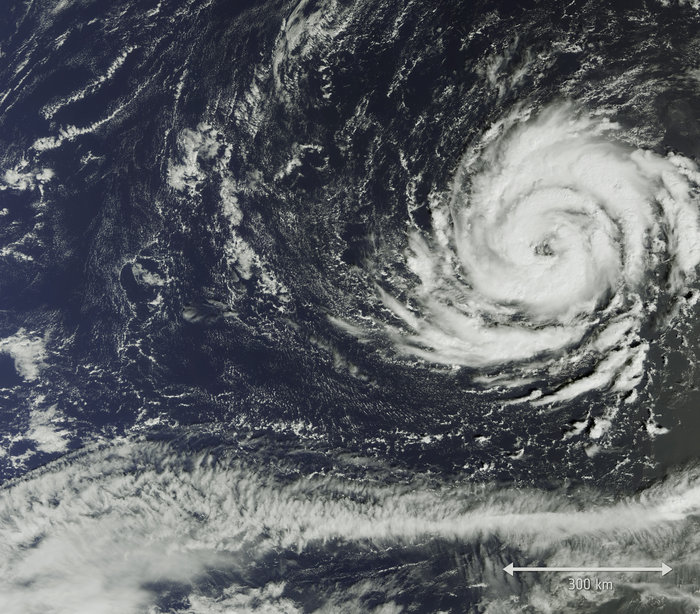
Possible hallmarks of a sting jet to SW of Ireland looking at Eumetsat airmass imagery, where dry air intrusion from aloft is wrapping into the southern side of Ophelia and allowing downward momentum of very strong winds aloft. Striations at the end of the hook seem to me to further suggests this.

-
 5
5
-
-
30 minutes ago, Fiona Robertson said:
Someone mentioned earlier that the still mushrooming cloud tops near the centre increased the chances of a sting jet. I can't rememeber who it was. Can anyone help here re sting jet possibilities?
With regards to a sting jet, normally they tend to form in the early stages of rapid cyclogenesis (RACY) of a mid-latitude depression, this may occur with extratropical Ophelia well before landfall over Ireland, as by the time it reaches Ireland it will already be weakening. However, downward momentum of stronger winds aloft in embedded convection, likely impressive dry air intrusion wrapping into the low also aiding in downward momentum of strong low level jet just over on the cold side of the cold front will certainly produce some sting jet-like powerful and damaging gusts.
-
4
-
-
Ophelia continues to weaken, now category 1 with max sustained winds of 90mph with central pressure of 973mb. Still pretty powerful if it made landfall though!
-
1
-
-
13 minutes ago, JeffC said:
Is the water she's tracking over now too cold for EWRC? Or could that happen again?
Unlikely, as passing over cooler and cooler water plus dry air (see WV image below) and cold front encroaching from the west (see fax) will tend to elongate and break up the circulation of convection around the centre of the hurricane. So eye wall will eventually fill in today IMO.
-
3
-
-
Can still see the eye in Ophelia, though not as wide or defined as earlier this morning
-
2
-
-
This tweet illustrates nicely just how Ophelia stands out from the crowd of major hurricanes over the years as being unusually far east, a big outlier
-
4
-
-
-
- Popular Post
- Popular Post
Any more spamming or trolling of this thread will be removed ... so be warned. Let's keep discussion civil and sensibly reasoned plz, this is not the place for trashing well known science with climate change as an excuse.
-
11
-
- Popular Post
- Popular Post
4 minutes ago, OPHELIA said:Ok please do stop, you guys keep forgetting the climate is changing, you have to accept this.....wow.
I think we have to accept you are trolling the thread with incorrect statements about how meteorology works.
-
10
-
15 minutes ago, OPHELIA said:
Can I take this moment to say and not contradicting your post but storms like this do intend to stay out in the ocean because that is what they feed from, it's as they say for every action there is a reaction :). This could in turn keep some form of strength for a little while, but I'm not counting on it.
By the time Ophelia reaches Ireland waters it will be extratropical meaning that it derives most of its energy from horizontal temperature contrasts of Polar and Tropical air masses along baroclinic zones i.e. Cold/warm fronts and occluded fronts. The large scale ascent of air at the surface created by divergence aloft by left exits and right entrances of jet streaks which the depression moves into helping to deepen the low if they phase favourably.
Whereas true hurricanes derive energy from warm sea temperatures above 26C, certainly the seas around Ireland won't be the main source of energy
5 minutes ago, karlos1983 said:@Nick F if “hypothetically” you were going to pick a spot in Ireland for landfall, where would you go... no pressure like
Most likely over the western side of County Kerry.
-
2
-
 1
1
-
-
Looking at GFS and EC precip charts, they keep heaviest rain over the Atlantic and western coast of Ireland on northern and western side of Ophelia, so rainfall may not be so much of an issue as the winds and coastal or tidal flooding will be. Of course, this may change if it tracks further east.
-
1
-
-
8 minutes ago, January Snowstorm said:
Hi Nick F
Bearing in mind Cork is low lying and Irelands second city is a red warning warranted in your opinion?
I'm not expert on oceanography, but certainly think there will be impacts of such a high swell entering Cork Harbour on a high tide being funnelled into bays and as far as the the city itself and causing tidal flooding low lying areas, particularly given the strong onshore winds and waves likely from the south.
-
2
-
-
ECM has up to 38ft or 11m just offshore of Southern Ireland on Monday evening, up to 29 ft or 8m Celtic Sea / southern Irish Sea by early Tuesday
-
1
-
1
-
-
00z EC and UKMO still appear to be tracking ex-Ophelia up far western side of Ireland, hard to tell if landfall given 12hr positions, but ECMWF will update on Icelandic weather service in 6hr positions around 8am, so will find out then.
Fortunately, the depression looks to fill quickly as it passes over far west of Ireland.
-
The unusually active hurricane season seems to be not going out with a whimper, as Ophelia now being a cat. 2 storm makes it the strongest an Atlantic hurricane that has been this far east (35.5°W) this late in calendar year on record.
18z still keeping Ophelia well west of Ireland, the 12z European models (UKMET-G, ECMWF and ARPEGE) tracking Ophelia over Ireland, be interesting if the Euros back west in the morning runs!
Have updated my blog recently which is tracking Ophelia:
-
3
-
-
-
4 minutes ago, crimsone said:
Wasn't the storm of 87 an entirely mid-latitude cyclone affair born in Biscay, though? It seems pretty settled in my mind that 87's Great Storm wasn't an ex-hurricane at all?
Yep, think you're right, it developed over Bay of Biscay rather than an ex-hurricane reintensifying, nonetheless still weird Ophelia makes potential landfall on the exact date of the 30th anniversary
-
3
-
-
Michael Fish on the BBC news this evening and I still remember well the night of the Great Storm of '87 coming to our village in Kent, even though 30 years have passed, it was kind of burnt in the brain for life, as did the Burns Day Storm of 1990 and January 1987 snowstorm. Wow, wasn't '87 an exciting year for weather? Anyway, kind of eerie that another ex-hurricane like the Great Storm comes a-knocking exactly on the 30th anniversary, though probably not a UK landfall as it stands for now.
But, nonetheless, seems surreal too that the NHC have a wind cone aimed at the British Isles
-
6
-
-
Blog tracking Hurricane Ophelia, which will head towards Ireland as an extratropical storm early next week.
-
Ophelia now a hurricane, change of title needed ...
000
WTNT42 KNHC 112031
TCDAT2
Hurricane Ophelia Discussion Number 11
NWS National Hurricane Center Miami FL AL172017
500 PM AST Wed Oct 11 2017
Intensity estimates for Ophelia still range wildly. Dvorak
estimates, both subjective and objective, continue to support a much
higher intensity than other satellite-derived maximum wind
estimates. Adding to the uncertainty, subjective Dvorak
classifications at 1800 UTC were higher than 6 hours prior, but
since that time, the ragged eye has become obscured in IR imagery.
However, a recent SSMIS pass at 1813 UTC indicated that the
convective structure of the cyclone has improved during the day, so
it wouldn't be surprising if the eye became apparent again shortly.
In an attempt to blend all available data, the initial intensity has
been increased to 65 kt, making Ophelia a hurricane. However, it
should be stressed that the uncertainty of the initial intensity is
higher than normal.
The hurricane is moving slowly toward the east and the initial
motion estimate is 090/3 kt. The hurricane is embedded within weak
steering flow, and only a slow northeastward drift is expected for
the next 24 h. After that time, an approaching deep-layer trough
should force Ophelia to accelerate toward the northeast. All of the
deterministic models are in fairly good agreement on the speed and
track of Ophelia, however the various model ensembles suggest that
the uncertainty is much higher, especially regarding the forward
speed of Ophelia beyond 48 h. The official track forecast favors
the deterministic model solutions, in part to maintain continuity
with the previous advisory. The track forecast is therefore close
to the multi-model consensus, but much faster than the various
ensemble mean aids.
Since it isn't clear exactly how strong Ophelia is, the intensity
forecast is low confidence. All of the intensity guidance indicates
that strengthening is likely for the next 24 to 36 hours, however
the near stationary motion of the hurricane could induce some
upwelling and limit the extent to which the hurricane may
strengthen. Around 72 hours, the shear should begin to increase
substantially as Ophelia begins to interact with the approaching
trough, and extratropical transition will likely begin, accompanied
by a broadening of the wind field and a gradual decrease of the
maximum winds. The global models indicate that this process will
complete by 96 h. The new NHC intensity forecast is slightly higher
than the previous forecast, but lies on the lower end of the
intensity guidance for the first 72 h. It is near the consensus
aids thereafter.
-
1
-
-
Interesting how ex-Ophelia low keeps a warm core just like a tropical storm/hurricane as it approaches to the SW of Ireland on Monday, unlike the more usual cold cored North Atlantic depressions we see. Certainly likely to be a lot of energy wrapped up in this deep low, wherever it may go.
-
4
-
-
- Popular Post
- Popular Post
So the models generally agreeing, for now, on taking ex-Ophelia north close to the west side of Ireland early next week, a close call for Ireland though, with a track further east threatening potential widespread severe gales. 00z UKMO takes this deep low NE toward western Scotland, rather than north toward Iceland like the other models, so western Scotland could come into the frame for strong winds too if this NE track were to transpire.
The long track north of ex-Ophelia from south of the Azores will draw a deep warm southerly flow from southern Spain / western Med for the weekend into early next week, some high temps indicated for Monday from the 00z Netwx-MR showing 25-26C for eastern England, would surely threaten some date records.
Strong jet stream next week looping N to NE across the UK could pull a few shortwaves NE that could spawn some deepening secondary lows moving NE from the Bay of Biscay. Long-way off for any certainty, but 00z ECMWF and the EC control indicates potential for such a low to move NE from Biscay across NW France and perhaps on to SE UK. All coming around the 30 year anniversary of the Great Storm of 1987 as well! Worth keeping an eye on.
00z ECMWF for mid-next week
All-in-all an interesting period of weather coming up, certainly not run-of-the-mill autumn weather, with ex-hurricane arriving from so far south and bringing unusual warmth with it too.
-
14
-
1 minute ago, Froze were the Days said:
Nice read there Nick for Laymans like myself
- I think it could be 4 winters though! 2013/14, 2014/15, 2015/16 and last winter have all been poor or relatively poor...
Actually, I think you're right, it probably was 4 mild winters on the run, was thinking 2013 had some cold, but that was early on in the year thinking more about it, Jan-April that year were below par.
-
- Popular Post
- Popular Post
Personally I have higher hopes for the coming winter snow and cold wise for lowland Britain than the last three winters.
The QBO has been negative for the last 4 months and continues to drop each month deeper into -ve territory. A negative or easterly QBO is linked to a weaker PV on average during winter and thus a weaker Atlantic jet which favours more blocking and greater chances of SSWs too. We have had an unprecedented long stretch of +ve/westerly QBO over the last few years, plus strong El Nino in the middle, which has resulted in a run of mild winters for the UK.
How much influence the forecast weak/mod La Nina will have on upper patterns in conjunction with -QBO - we'll have to wait to see, and be interesting if, in the Dec-Feb 500mb means, it plays similar to a composite of years with weak/moderate La Nina and moderate/strong -QBO, like the one below;
We also have weakening solar activity heading towards a solar minimum in next few years, how this solar cycle interacts with the QBO is a bit beyond me as the interaction seem rather complex, from what I've read, SSW during a wQBO are less likely than in a eQBO, but when they occur, statistically more often when there's a max solar cycle. However, a solar cycle min may not have such a big influence on SSW while in a eQBO phase. Though reading further it appears a solar min/ eQBO can increase the amplitude of the MJO.
All-in-all, a few cold winters more likely in next few years, whether 2017/18 will be one I can't guarantee, but certainly cautiously more optimistic it will be colder than the last 3 winters given the above
-
15


Hurricane Ophelia
in Hurricanes, Cyclones and Extreme weather worldwide
Posted
21.6C already at Capel Curig at 0900, which nestles in a valley in Snowdonia. Guess there must be some fohn effect going on there.