


fear sneachta
-
Posts
118 -
Joined
-
Last visited
Content Type
Forums
Blogs
Gallery
Events
Learn About Weather and Meteorology
Community guides
Posts posted by fear sneachta
-
-
I suspect rain may cause more disruption than snow. The ground is so cold it will more or less freeze on impact.
Ill be watching the radar carefully, usually these features break up and fizzle out before making it this far south, leaving us bone dry. The BBC precipitation forecast suggests the front will still be still fairly active down here, so I expect to see something fall from the sky, whatever it may be.
I think it might be a weak affair by the time it reaches Dublin but hopefully not. I went for a walk earlier and everything is certainly frozen over. It's 0 degrees and I'd be surprised if the ppn fell as anything other than snow. Then again, I've seen rain fall on ice this winter already so my confidence is already shattered! :lol:
-
Do i spy a monster Polar low in the Development north of Scotland?
Which chart did you see that on?
-
"Intense cold" I love that, haven't heard the likes since about 20 years.
The rain/sleet showers from the trough(s) on saturday evening here was disappointing considering the flow and the very recent previous snow, I'm afraid that will happen again tonight with this first frontal system
That occlusion/short wave/polar low-type feature is interesting. Those things have often lets us down in spectacular fashion but in this set-up the potential is very much there for something exciting. Alot now depends on the ability of the overall system to maintain instability, intensity and penetration south/westwards. Everything else (the exact track etc) is pure chance of course.
Most recent UKMO precipitation predictions indicating a possibility of up to 20cm in north and east Ireland. I'm sure it won't happen even nearly like that, but even a quarter of it would be fantastic.
On another note, how long will local authorities and residential management companies allow packed ice just to lie across paths and roads (other than primary roads)? You could argue that local residents should get out and clear, but that's very difficult with packed and re-inforced ice. If it snows again I think folks should get together and get out digging, because it looks like the powers that be are hiding and just hoping it will all go away quick. According to just about all forecasts, that's not going to happen for a week or longer
I think the authorities are doing the best they can. They come in for too much stick altogether.
-
Update from BBC:
Published at 09:00 on 4th January
All times are GMT (Europe/London, GMT+0000)
(Next update at 09:00 on 11th January)
Written by Elizabeth Saary
Summary
Staying very cold
December was a particularly cold month with temperatures below average in most areas. It now looks as though much of January will continue in the same vein with harsh frosts and further heavy snowfalls.
The devil is very much in the detail. I wonder if NI/Ireland will be seeing any of the snowfall she refers to or will it mainly be eastern England & perhaps Scotland?
I still think Ireland will see mostly dry weather until the 3rd week of January, when less cold temps push in with rain.
Published at 09:00 on 4th January
All times are GMT (Europe/London, GMT+0000)
(Next update at 09:00 on 11th January)
Written by Elizabeth Saary
Summary
Staying very cold
December was a particularly cold month with temperatures below average in most areas. It now looks as though much of January will continue in the same vein with harsh frosts and further heavy snowfalls.
Monday 4 January 2010 to Sunday 10 January 2010
More snow
Areas of sleet and snow will drift southwards across the UK during the first part of the week. At first, the most significant snowfalls are likely to be in Scotland and over the higher ground of northern England.
However, later in the week, the risk for more prolonged, heavy snowfall lies across many eastern and southeastern parts of the UK so we can expect some problems here with significant accumulations of snow likely to lead to some disruption.
Throughout the week, temperatures will remain well below the seasonal average with severe night frosts and daytime highs often remaining below freezing. Ice will continue to be a major hazard anywhere that rain, sleet or snow has fallen.
On the plus side, when it is not snowing, the air will be clean and clear with bright sunny spells, especially in more western areas.
Monday 11 January 2010 to Sunday 17 January 2010
Cold but often dry
High pressure to the west of the UK will maintain the northerly winds and intense cold for much of this period.
Some further snow showers can be expected, again mainly in northern and eastern areas but many inland areas are likely to remain mostly dry, with the best sunshine towards the west.
Monday 18 January 2010 to Sunday 31 January 2010
Little change at first
It will remain cold for the rest of January although there is a hint that temperatures may recover slightly towards the south and west eventually.
The weather will turn increasingly unsettled which may result in some further prolonged snowfalls - the west being more at risk during this time, although as temperatures pick up, southern parts could be more likely to see rain towards the end of the month.
-
its snowing heavy here. settling very well.

That's interesting, because it's not being picked up on the radar:
http://www.met.ie/la...nfall_radar.asp
Meanwhile, Met Eireann is saying that the rest of the week will be cold but mostly dry, with the exception of tonight and tomorrow.
The cold, but mainly dry weather, will continue through the rest of the week and over next weekend, across the whole country. There will be further severe frosts at night, and ice on untreated surfaces, some fog patches possible at times too. Daytime temperatures will be in low single figures at best, despite some winter sunshine, with frost and ice slow to clear. Tuesday night will be very cold with temperatures well below freezing in many places, and possibly as low as -7 or -8 C., in a few sheltered areas. Frost will be severe with icy surfaces. A few wintry showers are also possible at times, on eastern and northern coasts, but most parts of the country should be dry. Wednesday will be very cold and breezy with a fresh and gusty northeast to northerly breeze. Frost and ice will linger in places, despite some sunny spells. Most places dry, but some wintry showers are possible in places close to the east and north coasts once again. Very cold, frosty and icy overnight and for a time on Thursday. Most places dry and bright on Thursday with some weak winter sunshine, but there is a risk that a spell of rain sleet and some snow may affect the Atlantic Seaboard. Most of the showers look set to disappear for Friday and next weekend, with just a few possible on eastern and northern coasts, but the days and nights will stay as cold and frosty as ever.
-
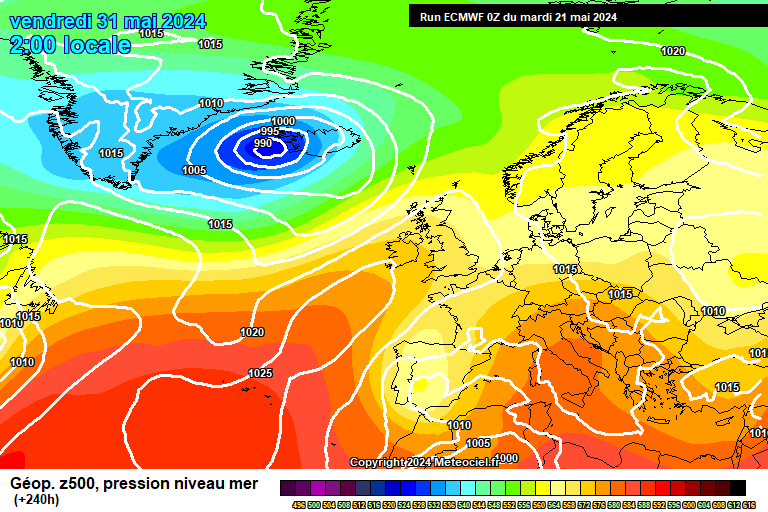
Heh, that cut off low at T+216 on ECM goes east into the continent, and could bring snow to southern areas:
http://www.meteociel...M1-240.GIF?03-0
No real sign of any breakdown from ECM tonight.
Yes, this cold spell seems endless. As a snow lover normally, I never before thought cold weather could be so tedious. However now, I'm tired and bored of bitterly cold, irritatingly icy, snowless, dry weather and am now hoping for a return to mild Atlantic southwesterlies in the not too distant future!
-
top of the evening!
Top of the evening to you too, a chara!
The weather really is depressing at the minute. Can't really complain about the past 2 weeks as near enough every day has been an ice day.
Although, who wants ice really? Bitterly cold and icy weather for 2 weeks and not much to show for it in snow terms...it's all rather tedious.
I'm now hoping for the mild weather to come back, to be quite frank. Come on Atlantic!!
-
It's gas! There's hardly any discussion on the Ireland thread - that's because there isn't much to talk about!!
It's just bitterly cold and dry and not a huge prospect of any real snow for any of us!
Meanwhile, in England's southeast, they are bracing themselves for 2 feet of snow between Wednesday and Friday!
-
We had 1cm overnight 23/4 Dec and 0.5cm yesterday evening; that's been it. Neither lasted more than 24 hours, although today and Dec 24 were both "mornings with snow lying" according to the official definition so we've been spared another winter with none of those (like happened in 2007/8, 1999/00, 1992/3 and 1991/2).
"Higher ground in Shropshire" is a different planet to Shrewsbury when it comes to snow; I presume your cousins lived somewhere like Stiperstones or Ratlinghope (where the postal address is Shrewsbury)- those areas have had about 8 days of snowcover and 10-15cm of it, to show how different they are from Shrewsbury.
I'm not that au fait with the topography of Shropshire. However, I can tell you that they used to live in a village called 'Much Wenlock' and owned 'The Wenlock Edge Inn', which, since changing hands, trades under a new name (which I don't know).
-
As someone who lives properly in the west, can you do me and us all a favour and take off your parochial spectacles? Thanks! You don't speak for 'the West' thanks. We've had a covering of snow here in my part of north Devon, some remarkable ice conditions, and some very cold nights. If -5.4C near me in Exeter doesn't constitute a cold night by west country standards then you may be comparing this with western Canada rather than western England. There have been a succession of very cold nights in this part. -6.3C in Yeolviton the previous night
I'm just back from a 9m run and it's bitterly, bitterly, cold with a stinging wind. It's 0C. Even with a slight rise over the next hour or so this will be an ice day in this part of north Devon (mean below freezing). That's properly cold and anyone suggestion otherwise is talking arrant nonsense.
I repeat: patience. The synoptics on the model outputs are fabulous, and some of those who are still complaining are going to have fallen as silent as the snow by the end of the week.
Sorry to be off-topic, but you say you went for a nine-mile run!!! Wow, that's very impressive, especially in this weather!
As for the models, I do hope all parts of the UK & Ireland see some snow during this coming week and that it doesn't remain dry.
The high forecast for next weekend would keep things bone dry if it were to sit there. I also hope it gets shunted west, well west.
Or another fun scenario for those in Ireland, would be that the high drifts east, coaxing in an Atlantic Low, only to shunt it all westwards again and leaving us with a dumping of snow!
-
just watched the rte farming weather for the week ahead, it was pretty good, presented by gerry murphy. a good bit of snow forecast for tomorrow night, especially in northern parts. best wintry forecast i have seen by met eireann. -8c tonight, temps no higher than 1 or 2c all week. sleet and snow showers nearcoasts all week, ice frost, perma frost during the day. it was impressive to say the least. :winky:
Met Eireann's website isn't saying there will be snow tomorrow, but rather rain. What did RTE say about tomorrow?
-
Met Eireann are saying this will fall as rain tomorrow.
And Wednesday's previously forecasted snow event has been pushed to Thursday.
-
Oh a gnome. Got ya now!! Sorry to hear you broke him!!
Will Wexford get any of these showers or will they die out as the GFS thinks , I'm about 10 miles from the east coast and 270 feet asl , anybody have any idea what I might get?
Is the GFS really playing down the potential for Irish Sea convection?
Don't see Wexford getting much precipitation tonight. But there are some clouds coming off the Irish Sea onto Dublin and we had a brief hail shower just there now.
-
I ment noam
Dunno what that it either! Never mind!
:) -
Disaster here now rapid thaw in dublin city centre.
That warm sector done serious damage much more than i thought.could have nothing by morning
There's definitely something of a thaw going on. The current temp here is still +2!
I went out for a walk this evening and you can definitely see that some of the snow and ice have melted since yesterday (Friday).
However, out where I live on the outskirts there is still a lot of snow lying. Urban centres are always going to thaw faster and sooner.
There is also a gentle easterly breeze, blowing the warmer sea temps onto us, keeping us above zero!
Broke my poor nom aswell lol
What's a nom?!
-
Greetings from Shrewsbury, the headquarters of the No Snow Club. One 15-minute snow grain shower on Thursday and the same for 2 minutes yesterday lunchtime, before the front from the north moved in last night and gave nothing but rain. Even though it hadn't been above 2C for three days and the soil was still frozen, it rained and didn't even sleet. Just the latest in a long series of letdowns (eg 2008 no lying snow all year, last Feb a max of 5cm when most places had 10-15, countless times when it's snowed 15 mles away and not here....).
Have you still got no snow there in Shrewsbury?
I've cousins who used to live there and they said they used to often get a metre of snow there about 25 years ago! They lived on higher ground in Shropshire.
Here in Dublin, we just got 1cm of snow on New Year's Eve. Although it's still lying, that's all we've got so far. This cold snap is too dry for my liking!!
-
Moderate rain here in Dublin cc
.Dam mild sector .washing away the snow.some still on ground,
Mind you, Dublin airport is reporting recent snow. It's dry where I am though.
http://www.met.ie/latest/reports.asp
Oops...it's just started sleeting here.
-
Just had a very light sleety rain shower in Dublin. So much for it being 'bitterly cold'!
The temperature drop has begun, now 1.1C.
Monday night looking quite good for snow across most of the country now.
Met Eireann is saying Monday will be dry for most.
Apart from isolated snow showers near north and west coasts, Sunday night will be dry but very cold with very severe frost and the risk of freezing fog patches inland. Air temperatures may drop as low as minus 10 degrees in places. Monday will be mainly dry also with some pale winter sunshine, but very cold with frost persisting for most of the day and roads and pavements staying icy. Tuesday will be dry in most places, but it'll be very cold and snow showers will affect coastal areas with fresh accumulations in these areas. During Wednesday there will be an increasing risk of longer spells of sleet and snow.
-
For most of Ireland, with the slight exception of the northwest, this cold spell has been fairly dry and quite tame as far as snow is concerned.
There seems to be very little snow associated with it. It seems like Tues/Wed will be are only real hope of any proper snow. Thereafter, it seems high pressure will be in charge, keeping things cold but as dry as a bone.
I feel this 'cold snap' is a damp squib in terms of snow. Loads of ice, yeah, but not much snow!
-
I'm just wondering...how accurate the GFS 'risque de neige' is generally regarded as being? It's showing a fair bit of snow for many parts of the UK & Ireland over the next week. I'm particularly looking at next Tuesday's chart with some reasonable snow forecast for Dublin. I'm wondering how big a pinch of salt I need to take with regard to these GFS charts!!
-
Met Eireann are predicting that a band of precipitation will whisk the south coast on Sunday. I wonder if there is any chance that this cloud could move more northerly than they currently think and dollup Dublin with lots of snow!!
-
Just had a moderate rain shower here in Derry that last for about 30 mins. Can't really understand why it didn't fall as snow. Would be nice to wake up to another dusting in the morning. Last night we had a heavy snow shower at about 11, left everything white. Its now been nearly 14 days with snow on the ground and temperatures hovering around 0. This cold spell is really something special and things are looking really good for the rest of the winter. Happy New Year to everyone on here.
Yeah, how come it fell as rain? The temps are low enough for snow.
A few minutes ago, I noticed a few flakes falling here in Dublin. Lasted about 1 minute!
-
12z GFS shows far more ppn associated with the trough moving down tomorrow. Would be surprised not to see something now.
Also heads up on a possible event Monday night, with significant ppn showing on the 12z. If this continues expect parts of the north to have a weather watch like eastern areas of British mainland have at present.
Pressure beginning to drop though the night, and hopefully that will trigger a few more showers, real hit and miss though and a nowcast situation as The Watcher mentioned earlier.
Do you think Monday's event could sink south?
-
has anyone read the met eireann weather forecast. jeez ive never read a forecast like that before.
I know. However, Leinster don't seem to figure much in their snow forecast. It's all about Ulster and Connacht! NOT fair!!!!


 .
.


Ireland Cold Spell Discussion:
in Spring Weather Discussion
Posted · Edited by fear sneachta
It's misty. That's probably what you're seeing.
Reports are coming in from Cavan and Monaghan that it's falling as light rain.
Maybe the dew points aren't low enough. But otherwise it's mystifying, as it's bloody cold out there!!
Anyway, I'm off to bed!