


Eastbourneguy
-
Posts
56 -
Joined
-
Last visited
Content Type
Forums
Blogs
Gallery
Events
Learn About Weather and Meteorology
Community guides
Posts posted by Eastbourneguy
-
-
2 minutes ago, Essex Chelle said:
Look im no expert I've been here 12 years and I learnt few things and love looking at radars so just popped on rain today and noticed this big red growing blob appearing out off of northern France, its growing in size quite rapidly, someone take a look?

That's an Atlantic front trying to push in but failing to for a day or two!
-
 1
1
-
-
2 minutes ago, Oaks said:
Could someone please tell me what this twig like feature that's circled means ?
Convergence line. Winds backing due to friction over southern East Anglia, meeting the air following roughly the isobars, not subject to as much friction over the sea north of Kent and forced to rise.
-
 1
1
-
1
-
-
4 minutes ago, londonblizzard said:
Re ground temperature:
snow also not really settling on tree branches well above ground levelPollution then but it is really a very strange one!
If the sub-surface levels are really warm, they would be radiating heat out as well, which would impede settling anywhere.
I did think the depth of this cold would be enough, but the weather always is a little git!
-
In this case, I would guess that the problem isn't that it's pure water not able to freeze, because the ground is a surface that pure water should be able to freeze on at 0C. (conduction from the ground surface below might also be hindering this). It could be that as this snow has come from Europe, it's fairly polluted and has lowered the freezing point of the water that way.
-
2 minutes ago, Mizzle said:
I'm a little off topic here, but your ppst reminded me of a lecture I went to on Antarctica. They did an experiment to show how water won't freeze at 0°C if it is completely pure. The moment an impurity hits the water it freezes instantly. They had some cups of this super cooled water and the moment your lips touched the water to drink it instantly crackled and turned to ice. Incredible and almost magical!
This is true. Water doesn't freeze homogeneously in the atmosphere until as low as -37C without cloud condensation nuclei in the atmosphere or a surface haha.
-
1
-
-
I would say it has to warm ground temperatures just below the surface, because if it was sublimation everything wouldn't be as wet! Not 100% on this though.
-
1
-
-
3 minutes ago, yamkin said:
Both 500 & 850 hPa's at low temps -28C +/- will create instability allowing the ppn to perk up a lot more
Instability comes from the difference in temperature between the two layers (warmer air rising). If both were the same temperature you have negative buoyancy (neutral really). The 850s are around -10 to -12 currently, and no air parcel is rising to 500 hPa via convection.
-
2
-
2
-
-
5 minutes ago, danm said:
Brilliant post!
-
1
-
-
36 minutes ago, yamkin said:
The upper 850hPa temps are around -28C -/+ and coupled with the upper 500hPa around the same temp will create instability = heavier snow
500hPa is more favourable from 3pm for the areas S-SE
The following excerpts are courtesy of JP - John Pike
I'm struggling to understand this. You mean the 500 hPa temps are -28c? You want a large negative difference between the two and to be honest, you would use a lower down height than 500 hPa because no convective cloud top in winter will be that high.
Obviously a colder 500 hPa level implies also cold lower down at 700 hPa ish, but not always!
Edit: The post on the next page with the Herstmonceux tephigram illustrates this perfectly, big chonky inversions. To be honest, it's probably why 850s have become so widely used in winter, because it's roughly where cloud tops from convective easterlies will be, so you can have a rough guide to instability.
-
1
-
1
-
-
I definitely expected tonight to be convective cell looking like the stuff up north. Looking very bandy, the warning area is going to get absolutely pasted.
-
My incredibly lucky girlfriend has somehow managed to get more than my folks back in Eastbourne near Manchester. A very thin streamer hitting her. She's already had about 5 snowfalls this winter!
-
The Met Office amber warning area looks pretty obvious now haha!
-
4
-
-
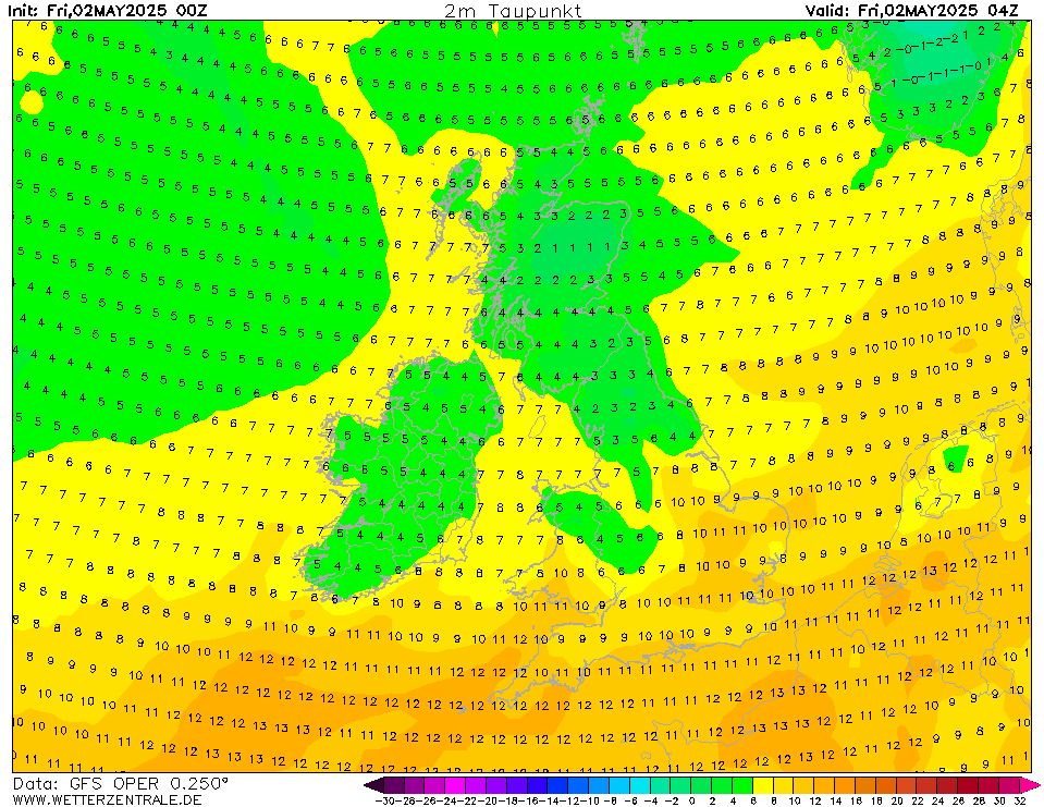
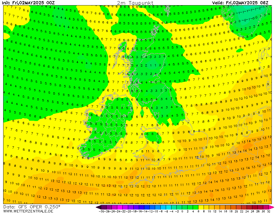
Come on convection, do your worst!
-
To lighten the mood, dew points on the GFS aren't widely expected to be below freezing yet.
They fall to below freezing around 6am
Which actually coincides with the band ever so slightly nudging further west (forecasted anyway)
Also, it hasn't been that cold in the south east, so it was always going to take a bit of time for the transition. The Met Office warnings won't mention rain to begin because most people aren't like us, looking out the window at 4am haha. By the time they look out the window things will likely look much different!
-
2
-
1
-
-
Just now, Big Dave said:
And from Exeter you popped in just to get your kicks right?
I live in Exeter currently, the name gives away where I am from.
-
1
-
-
It's like a nursery in here.
-
2
-
-
The GFS is still out on it's own regarding having everything slightly further north Sunday, reflected in the 850s.
GFS
UKMO
GEM
It doesn't really make too much a difference for most of the southeast regarding snowfall or rain, but coastal areas do fall into slight jeopardy if the GFS was to be true. There's a difference of around -6 C at 850 hPa between the GEM and GFS at only 72hours over kent and sussex!
Areas further north would benefit from this extra north push for dynamic snow, but I really think getting in the properly cold air fully will be beneficial for most down the road, from convective showers, to it being colder at the surface when the Atlantic inevitably fights back. The GFS is continuing to want this low to modify our lovely Pc air more than I would like.
-
5
-
1
-
-
I love watching people from the midlands complain about non event dry easterlies when
1) It hasn't happened yet
2) It's an easterly, obviously the further inland you go, negates your chances of showers
3) You're literally in the prime locations for frontal snow when the Atlantic comes back.
4) It's really irritating.
-
1
-
-
16 minutes ago, Daniel* said:
That wasn’t quite the reality the 28th February 2018 was by far my snowiest day in my part of London 2 miles east from Tower Bridge, Wednesday morning had a serious dumping some of heaviest snow I’ve seen dropped 5-8cm in less than a hour. Oddly showers through Estuary aligned much more like there was an easterly than an eastsoutheasterly which I’ve always known to be dry. I think the upper flow was different to surface flow it’s not as easy to interpret as you think.
I should probably have referred to kent and sussex instead of the southeast as a whole haha! Those showers start bang on north of Kent when the sea track becomes larger.
Edit: It is definitely odd how the furthest south streamer is pretty much easterly orientated as you said, while the ones further north are definitely ESE! Good old weather.
-
- Popular Post
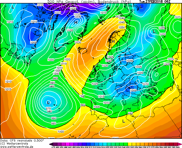
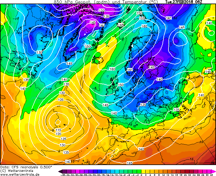
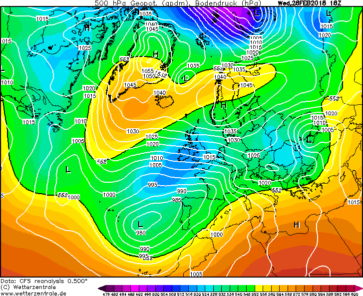
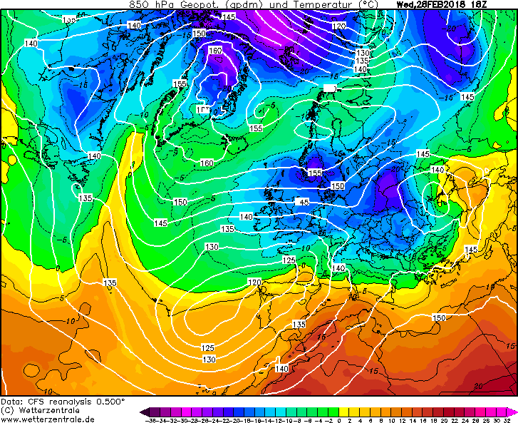
With regards to instability, I would say in basic terms we have the SLP being much lower than 2018 in the southeast, for when the flow was a more favourable ENE direction. Pressure was 1030/1025 hPa when there was decent sea track (though a slack flow).
2018
Once the flow became much stronger as the pressure dropped, the ESE nature of the flow killed much of the convection from the shortsea track in the SE.
Incredibly cold 850s, but too dry a flow now.
Comparing now to 2010 for the southeast is probably a closer match.
This brought a foot of snow to Eastbourne and much of Sussex I believe, with some very so so, 850s, showing why they are not the be all and end all! SSTs being very high in December probably aided the convection in this case.
Back to current prospects...
Talking more about the north now, while the depth of cold is not as strong as 2018, the SLP is around 10/15 hPa lower, which will aid convection here. (There is of course much more to look at when thinking about convection).
I think talking about amounts beyond using the word significant is probably wrong at this time. However, how many times in the past have we seen dry easterlies forecast and people have to be reminded that the models aren't going to resolve convective showers very well at that time frame. Currently, the GFS, UKV and EC are modelling reasonable totals in the east for many, from purely parameterized convective processes. We shall see what the high res models think soon, and even they won't get it completely right!
Good night everyone!
-
19
-
2
-
Meanwhile, over the pond...
Back to the UK... 3/4 days of a potent easterly followed by war with the Atlantic. I don't think anyone can ask for too much more!
ps: For cold and snow lovers anyway!
-
6
-
1
-
-
The low is ever to slightly too far north for coastal counties in the south on the 12Z ECM according to the raw output. But it's go time 30miles or so inland!
-
2
-
-
Okay GFS, interest peaked once more. Off to the garden path I go.
-
2
-
-
Evening all!
Models currently have a lovely time trying to resolve an extremely amplified meridional pattern, with trough disruption causing chaos.
Just look at how amplified the whole pattern is from North America across to Europe.
GFS OP @+72
But then look how even more amplified some members like P16 are at the same time frame. The ridge into trough in the western Atlantic is distinctly more elongated.
I've drawn arrows to indicate the potential trough disruption occurring, I think the one in the western Atlantic is most important here. On P16 the trough disrupts in the next 24 hours, cuts the low off from from it's fuel source of cold air, leaving it to weaken and meander around not doing too much in the Atlantic. This allows some retrogression of the the high to the east and the western high to build into each other in a favourable location, as seen in the below three time steps.
By T+120 we have a new shortwave to worry about to the north of the UK but at least we have built a favourable high!
T+78
T+84
T+120
Contrast this with the Op run and with no trough disruption in the Atlantic by T+84, keeping the low fairly strong and preventing any retrogression of the high over towards southern Greenland. Then by T+120 the low has moved towards our southwest, dragging in south westerlies!
T_84
T+120
Other GEFS runs that have also have the trough disrupting in the western Atlantic are 7,9, 10 & 12 (probably some more too) and all lead to rather nice conditions for coldies following!
This is of course without thinking about the trough disruption happening over the UK on Saturday and the cold high that is being very reluctant to move in mainland Europe!
Night peeps!
-
7
-


Winter 2021-22 Chat, Moans and ramps thread
in Spring Weather Discussion
Posted
Evening all, some absolute filth available on the 18Z ensembles for between Christmas and New Year, not for the faint hearted. Can't wait to be told off by the family on Christmas day while I'm glued to my phone watching the latest runs rolling out!