


shiver
-
Posts
36 -
Joined
-
Last visited
Content Type
Forums
Blogs
Gallery
Events
Learn About Weather and Meteorology
Community guides
Posts posted by shiver
-
-
http://www.wetterzentrale.de/pics/Rtavn184.png gfs has this going a lot further north than forecast who will be right?
-
Might just reach Nottingham, Shivers. Very borderline to be honest. Maybe Nick F may have a better idea but I'm only going by METO radar and the PPN seems to be slowing down as it moves NE.
Back to fine drizzle now but wind seems to be picking up a touch.
Phil.
tanks looking at the rain today radar looks like it could go further north than notts?
-
Looks like fun in Northhampton/East midlands
how far north is this going anyone??
-
what do people think the northern limit will be??thats probably just down to intensity.
looks at though north of birmingham wont get much until after dark - when the fun and games start

-
you got a crystal ball 12z???12z is a total downgrade surprise-surprise. was looking forward to a few good runs of early next week being snow-fest Tues, but now its very light snow, and the end of the week is rain with above freezing temps. Hopefully an isolated run...
well, as per usual, it looks like the game that never started, is surely over for Notts today and most likely tomorrow... maybe next winter.....
-
Yes temps/dew are quickly rising as the day goes on.
lol wum
-
good news if you like snowI'm quite new to Netweather - I can't seem to find a media thread, so excuse me for posting this on here MODs
Has anyone seen the latest countryfile forecast at 6:50pm?
Good/Bad news?
-
It's a very dry run for Scotland (away from the East coast for a brief time), very dry for Northern England (away from the East coast for a time) most of the Midlands, all of Wales and all of Ireland. And SW England.
http://www.wetterzentrale.de/pics/Recm2401.gif looks like a sinker to me ian
-
http://www.wetterzentrale.de/pics/Recm1921.gif well done Mr Brown keep jinxing that sinking high keep up the good work
-
This is getting ridiculous now, I've been watching the models for years and this is really taking the mickey. Also the biggest flip in the ensembles I've ever seen.
Improvement in the other models too.
No doubt they will all flip back to tropical SWlys again tonight. Pretty much impossible to make sense out of the models at the moment.
same here i have never seen this before in the last 8 years once the modls flip they usualy stick to that outcome but this is different and for that reason im going with a very cold easterly outbreak
-
lol doesnt matter how we get there as long as we get there easterly is an easterlyNo because it was NOT right about how we got there.
-
has anyone thought gfs was right all along in showing the easterly first if it comes off
-
Oh dear things must be bad if you're looking at the Russian model!
It actually looks similar to the ECM in the earlier timeframe. The UKMO tonight unfortunately go with their own model in the fax charts which is disappointing although the 120hrs fax chart isn't quite as horrific as I expected it to be!Those shortwaves coming out of the USA are a real pain as they just feed that Atlantic trough, if you noticed the GFS tries to disrupt the trough sending that shortwave se wards but then up pops its reinforcement shortwave which deepens and spins ne'wards.
yep that 120 fax looks nothing like the countryfile fcast at the same time something has changed i tell you
-
Given the GFS of recent days is anyone taking any notice of it? The problem remains the trough in the Atlantic, this just gets topped up by a stream of shortwaves coming out of the USA,the trough cant disrupt or weaken whilst this is the case.
have you seen gem 12z nick fi is t72
-
i have seen stranger things mate it nearly does it at t96 a slight change and we would be looking at completOh great I'm sure the ski resorts here in the Pyrenees and Alps will be looking forward to that! The only interest I have in foehn effects are in the summer!
I 'm hoping the rain stays away here and the models keep enough of a ridge from the block to keep it dry, anyway given the ECM has switched again in its FI output from this morning with it now keeping the notorious block to the east rather than edging the trough through perhaps it might go the whole way tomorrow and bring back an easterly! that was just a joke!
ely the opposite at what we are
-
afraid not they have just coppied the ecm which was an outlierAfraid not. The FAX charts have the most important thing of all...human input!
-
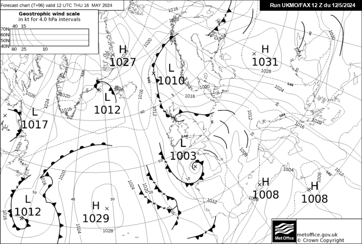
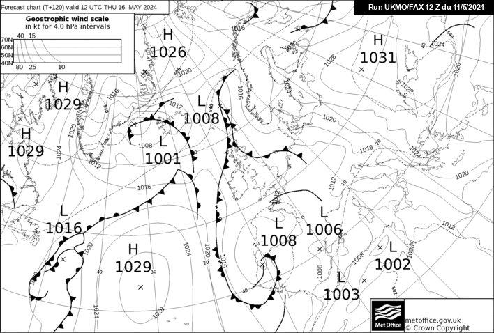
FAX charts out, and they go with the ECM model tonight:
T+96: http://www.meteociel.../fax/fax96s.gif
T+120: http://www.meteociel...fax/fax120s.gif
I can't see much hope there for an easterly from that T+120 chart.The UKMO 6 - 15 dayer will surely catch up tomorrow now.
yes but that makes the fax an outlier many twists and turns to come
-
Well I think we've learnt a harsh lesson here and its the UKMO should be known as the dream killer! this model annoys me, it never progs a cold set up when the others show milder but is happy to implode another easterly!
Now that the dust has settled and everyone has got their frustration out of the way lets move on and try and plot a way forward. If you take out the extreme solution of the UKMO and go with the middle ground solution of the ECM where does that leave us, well not quite at the prozac stage because the ECM is still much better than the UKMO at the 144 hrs timeframe.
The ECM at 144hrs could still develop more favourably if the energy goes south rather than north and for this reason and given that theres still model disagreement we should hold fire before calling winter is over etc.
We have to accept that more energy will spill forward off the main trough so the quickest route to the easterly is now very unlikely, so we have to move to plan B. For the timebeing this is still an option but for this we still need the misery model to backtrack tomorrow.
Using a horse racing analogy, the horse might be tired and scrambling over the fences but hasn't unseated its rider just yet!
well i would wait for the ensembles because this is a warm run for holland as well
-
errrr it hasnt happend yet we are talking about charts in lala land there will be loads of changes yetExpect the MO 6-15 dayer tomorrow to dramatically change to mild and above average temps for around 7-9 days time.
What a U turn, with the GFS holding its head in shame..
-
lol codge whats wrong with two you havnt been banned have youHi!
I'm new to this forum.
Looking forward to the ECM 12z this evening
Codge
-
http://www.jp2webdes.../two/ensembles/
http://91.121.94.83/...ndres&runpara=0
Ensembles not as good as the 06z. There is agreement on surface temps being cold so some members must be going for Faux cold rather than the true easterly with associated uppers. IMO things are going the wrong way for a full blown Beast from the East. Most likely outcome is a SE feed with Faux cold and anticyclonic.
I think the pink ensemble on the surface tempt is the UKMO solution!
do not agree i think its low pressure undercutting the block sending higher 850s north but the surface remains cold
-
Equally no Euro model supports the UKMO either.
http://www.wzkarten3.de/pics/Rukm1441.gif the low stalls the next chart shows it turning colder imo and metos
-
http://www.emc.ncep.noaa.gov/gmb/STATS/html/acz6.html hmmmm ecm last in the stats over the last 6 days
-
Well at least its a choice between very cold or bitterly cold! Overall though we should be happy that both the GFS and ECM are showing easterlies. Will be intetesting to see what the UKMO do with the fax charts,some modification at 120hrs towards the ECM would be a good sign.
http://www.knmi.nl/exp/pluim/vijftiendaagse/index.html
lol next ice age


 It actually looks similar to the ECM in the earlier timeframe. The UKMO tonight unfortunately go with their own model in the fax charts which is disappointing although the 120hrs fax chart isn't quite as horrific as I expected it to be!

Midlands Cold Spell Discussion
in Spring Weather Discussion
Posted