


johncoolj
-
Posts
69 -
Joined
-
Last visited
Content Type
Forums
Blogs
Gallery
Events
Learn About Weather and Meteorology
Community guides
Posts posted by johncoolj
-
-
Thanks for your replies on the issue. Well being a snow freak myself I just hope that this current solar minimum leads to a grand solar minumum and a few of the type of extreme Winters that were experienced in the early 19th Century.
 brrrrrrr
sounds good to me snowray
lets hope for some 1700 style winters
-
So in essence narrowing the temperate 'comfort' climatic zones. It is this idea that would theoretically create a larger ice cap(greater arctic region).
If the North Atlantic Drift or GS has infact weakened it is quite worrying. However i dont think I quite believe it just yet. Not enough scientific agreement across the board imo.
But that could be due to not knowing time frames, general behaviour or cycles of the current over great timespans. I believe we only have a couple of centuries data on any ocean currents, if that??
All in all quite interesting.
I never new the n a c effects the jetstream
do you mean it could cause a change in the jetstream as in not coming over the uk like it use too
-
Was there ever snow on bonfire night in Uk or Ireland
if so anyone know the years there was snow.
Must also point out last year on this forum most where saying warm normal winter ahead
yet this year most are saying cold with snow
just because of last years icy winter
odds of another cold winter are low i would think
-
Atlantic winter... I think we will have a Positive NAO and the only chance of cold through 1-2 day northerlys as low pressure clears through.
SNOW-MAN2006
Has anyone else noticed this
look the worst cold winters in uk notice anyting ?
1916-1917
1932-1933
1946-1947
1962-1963
1978-1979
1994-1995
2010-2011?
16 year gaps between them well i know 2009-10
was a cold one but what if the 2010-11 is the really cold one
this is strange
Cold winters usually come in groups, so it could be cold this winter. Also think of the 16 year cold winter pattern, 2011,1995,1979,1963,1947
WILL 2011 BE ANOTHER 63 OR 47 WINTER
-
Excellent post and forecast snowstorm, fingers toes, legs and arms all crossed that you are right! Some fantastic weather possibilities there!
Snowstorm did u do a forcast last winter 2009 if so how did it go
-
Some overreaction in this thread i have to say..
Firstly, i have not seen anybody saying that we have been in a solar minima, the solar cycle is widely acknowleged and we achieved the solar minimum in November 2008, solar activity is actually increasing again.
Secondly, in regards to the Maunder Minimum, it is true that over the next century solar activity will be quite low which may have an effect on global temperatures, however you can not claim it has started on the basis of solar activity increasing later than expected and probably not to the same level as forecast, though from 2015, we are likely to see prolonged minima.
Lastly, right now global temperatures are increasing, primarily lead by thermal ocean expansion, nobody can deny this.
the gulf stream is weaker then it should be and has been for 4 months now
-
That chart is from last month!
where did you get the chart that shows the cold temps in dec cant find that one
-
Well according to the guru of Global Warming Al Gore,it could well happen the day after tomorrow. Um,Thursday it is,then.
have a look at this video on the gulf stream lastest info
-
A while back I said that I would wait to see what the hurricane season would bring to our shores. Right now we have two major tropical systems in the atlantic, and if the GFS is to believed none will make it over as extra tropical features. Instead they will slowly degrade while moving towards Greenland. We did see something like this earlier on this year, with weather systems in the atlantic almost being turned on there heals and going off in the opposite direction. This year it has started even earlier.
The NAO is also negative and continues to be stubbornly so.last year at this time it was positive and brought along with it a spell of wet and windy weather that broke my hubbys wind turbine.
Its been what I would call a benign summer and continues to be so as we move into autumn. I cant see no let up in the current situation. I think we could very well be in for a repeat of last winters slack, very cold airflow, but this time starting much earlier. We just need that air to cool over the continent and we will get what europe gets most years.
There has been another thread about the gulfstream, it has switched off, but it hasnt got the power it should have at this time of the year either. If the southern ocsillation can swtich moods Im sure the gulfstream is more than capable of slowing down as well.
good post you seem to know a lot
your say the gulf stream hasent got the power it should have what percent do you think its weakend by like 20 percent or what
also will this effect uk ireland tem,ps this winter
-
The posts by ch and Damian are first class posts and explain very well which comes first. As they have explained the main drivers are teleconnections prior to the AO and NAO not the other way round.
its out folks joe bs winter euro forcast looks like a normal uk winter so mild and wet i bet
To My European readers.
You may have noticed a marked decrease in my postings in the last month or two. This is because of new duties I have here that really mean I have very little time to put forth the kind of honest effort that ethically I feel bound to when making a forecast. I have never backed away from a challenge, but I find my position, as far as trying to get out and there and keep you up to date, impossible to maintain. There is only one of me, only so many hours in a day and while my first love is the kind of pattern dissection needed to give you hints on your weather, I am no longer capable of doing this in a consistent fashion, because of these other things.. for Europe
I have seen the emails wanting to know about the winter. Again, to put together a forecast and line things up the way I do, takes a long time, and what I now do takes away from that time. My gut feeling is the core of the cold this winter.. in relation to normals, runs from the Alps to the Balkans. I dont think Great Britain is as cold as last year, more or less a normal winter. But this will be a rough winter in areas in central and eastern Europe, the interior part of the continent. That is a thumbnail sketch, a rough look. One more things, precip will be a bit below normal for much of Europe this winter.
i actually feel a bit guilty about putting out something like this because it is not how I do things.. I have a code I live by. On the other hand, I guess I did not realize how many of you follow me over there, and I am moved. I will try my best to put together a forecast, that right or wrong, I can feel I did my best with. Again the amount of time that has to be devoted to these new work requirements is close to 10 hours a week and that is time I spent researching things.. and may I add enjoying myself while I did it. I cant say that I enjoy what I am doing in this other option, but as the great Christian minister Oswald Chambers said, it is those that can find glory in drudgery that are actually reaching for the highest ideal.. Anyone can do something when its all chocolate and roses, which is what the challenge of putting together a Euro forecast is too me, a labor of love.
Believe me I am trying.
-
-
2010/11 Winter Weather Forecast
Last winter saw below average temperatures and heavy snowfalls for a large part of December and January, before becoming slightly milder through February. But what are the indications for this winter? Will we see a return to the Atlantic driven, mild winters? Or will the cold and snowy weather continue?
The reason last winter was so cold was due to an exceptionally negative Arctic Oscillation (AO) this meant that high pressure developed across Greenland and something known as Northern Blocking developed, this allowed freezing air to flood across Europe and over to us here Ireland in the UK. This winter? The indications are looking promising for another cold and snowy one.
Firstly, we’ll take into account the Sea Surface Temperatures or SSTs, the chart below shows us both the warm and cold anomalies
Sea Surface Temperatures AnomalyWe also have areas of blue in the Mid Atlantic, this suggests that we’re likely to see high pressure developing and building up into the Atlantic, when this happens low pressure systems get stuck in the North Atlantic and subsequently, cooler air from the Arctic heads Southwards.
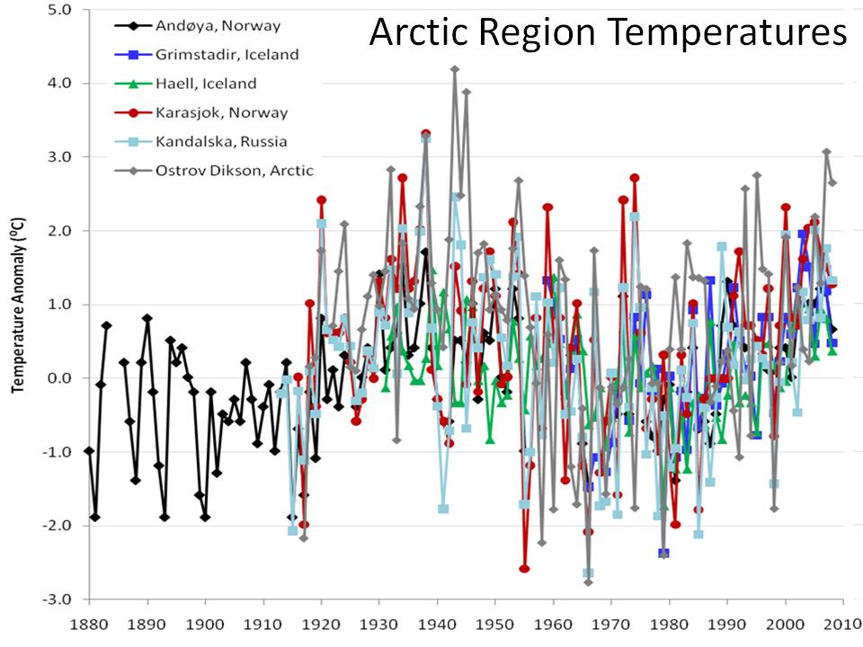
Another thing to take into account is the low sunspot activity in the last 2 years or so. Historic data show that during times of low sunspot activity, the UK experiances unusually cold winters, 1962 being one of them.
The Arctic Oscillation and North-Atlantic Oscillation are other things we should take into account, however because these are more variable and can change on a day to day basis, it’s much harder to use these to help forecast more than 5-10 days out, although we’ll take a look to see how they’re doing anyway.
North Atlantic OscillationArctic OscillationWe also must take into account the fact that the Arctic has had one of the coldest summers on record, meaning we’re unlikely to have a problem with getting an embedded cold pool into place, ready to flood Southwards.
Taking all these factors, and more into account. I think we’re likely to see a generally damp and dull start to Autumn, before things begin to turn increasingly cold as we move through October and into November. I’m forecasting another cold, and snowy period of weather, particularly from the middle of November through until the middle of January, before we see the Atlantic kicking into gear again bringing some mild, stormy weather to end the second half of winter.
The Gulf Stream
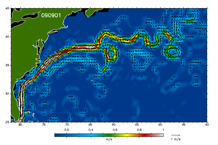
I don’t think I could create this forecast without mentioning the current state of the Gulf Stream. It’s something that’s been a hot topic amongst weather forums in the last few weeks, and here’s one of the reasons why. This graphic shows what the Gulf Stream was like in September last year.
September 2009September 2010Winter 2010/11 Overview
So just to summarize, I’m predicting a cold start to winter. I believe the first cold spell to take hold during the second part of September with frosts becoming more frequent across the United Kingdom and early snowfalls pushing down from the North and into Scotland and perhaps higher hills in Northern England.
I expect the first half of winter to be generally cold and snowy, as cold if not colder than last year. I think it’ll be generally cold and snowy through November to the middle of January before high pressure begins to break down and the Atlantic takes over for the second half of the winter bringing spells of wet, mild and windy weather, with brief cold snaps as low pressure systems push Eastwards into the North Sea.
The oranges/reds on the image above show us where above average sea surface temperatures have developed. The blues/purples show us where below average temperatures. If you look at the Pacific Ocean, you can see a large area of dark blue and purples. This is known as a phenomena called La Nina, and it’s a cooling of the Pacific Ocean. Although not fully understood, it is believed to lower global temperatures and bring colder weather to certain areas and that usually includes the UK.
The NAO is currently forecasted to shoot up into a weak positive before slowly moving back down into a weak negative. This sudden change suggests we’re likely to see the Atlantic becoming slightly more active in the next couple of days, we’re likely to continue this unsettled and cool theme for the next week or so at least. When we have a negative NAO, we’re more likely to see high pressure developing in the Atlantic, when we see a positive NAO, we’re more likely to see low pressures developing, and in turn, turning our weather more unsettled.
The AO is currently forecast to remain in a weak negative, perhaps becoming increasingly negative during the next 5-8 days. When we have a negative AO (as seen last winter) we have high pressure developing across the Arctic where we want it then if the correct conditions present themselves, that cold air will flood Southwards towards the UK. A positive AO means we see something called the Polar Vortex, which is a system of low pressure systems across the Arctic which make it far harder to lock ourselves into a cold pattern for more than a couple of days.
And here’s what the Gulf Stream is looking like this year
If you compare the two images above you can see there has definitely been a slowdown and slight decay of the Gulf Stream over the course of the last year, and this is what has gotten so many people interested. Whether this will have any effect on the weather in the coming months is yet to be seen, however.
-
2010/11 Winter Weather Forecast
September 12, 2010Daniel SmithLeave a commentGo to commentsLast winter saw below average temperatures and heavy snowfalls for a large part of December and January, before becoming slightly milder through February. But what are the indications for this winter? Will we see a return to the Atlantic driven, mild winters? Or will the cold and snowy weather continue?
The reason last winter was so cold was due to an exceptionally negative Arctic Oscillation (AO) this meant that high pressure developed across Greenland and something known as Northern Blocking developed, this allowed freezing air to flood across Europe and over to us here in the UK. This winter? The indications are looking promising for another cold and snowy one.
Firstly, we’ll take into account the Sea Surface Temperatures or SSTs, the chart below shows us both the warm and cold anomalies
Sea Surface Temperatures AnomalyWe also have areas of blue in the Mid Atlantic, this suggests that we’re likely to see high pressure developing and building up into the Atlantic, when this happens low pressure systems get stuck in the North Atlantic and subsequently, cooler air from the Arctic heads Southwards.
Another thing to take into account is the low sunspot activity in the last 2 years or so. Historic data show that during times of low sunspot activity, the UK experiances unusually cold winters, 1962 being one of them.
The Arctic Oscillation and North-Atlantic Oscillation are other things we should take into account, however because these are more variable and can change on a day to day basis, it’s much harder to use these to help forecast more than 5-10 days out, although we’ll take a look to see how they’re doing anyway.
North Atlantic OscillationArctic OscillationWe also must take into account the fact that the Arctic has had one of the coldest summers on record, meaning we’re unlikely to have a problem with getting an embedded cold pool into place, ready to flood Southwards.
Taking all these factors, and more into account. I think we’re likely to see a generally damp and dull start to Autumn, before things begin to turn increasingly cold as we move through October and into November. I’m forecasting another cold, and snowy period of weather, particularly from the middle of November through until the middle of January, before we see the Atlantic kicking into gear again bringing some mild, stormy weather to end the second half of winter.
The Gulf Stream
I don’t think I could create this forecast without mentioning the current state of the Gulf Stream. It’s something that’s been a hot topic amongst weather forums in the last few weeks, and here’s one of the reasons why. This graphic shows what the Gulf Stream was like in September last year.
September 2009September 2010Winter 2010/11 Overview
So just to summarize, I’m predicting a cold start to winter. I believe the first cold spell to take hold during the second part of September with frosts becoming more frequent across the United Kingdom and early snowfalls pushing down from the North and into Scotland and perhaps higher hills in Northern England.
I expect the first half of winter to be generally cold and snowy, as cold if not colder than last year. I think it’ll be generally cold and snowy through November to the middle of January before high pressure begins to break down and the Atlantic takes over for the second half of the winter bringing spells of wet, mild and windy weather, with brief cold snaps as low pressure systems push Eastwards into the North Sea.
The oranges/reds on the image above show us where above average sea surface temperatures have developed. The blues/purples show us where below average temperatures. If you look at the Pacific Ocean, you can see a large area of dark blue and purples. This is known as a phenomena called La Nina, and it’s a cooling of the Pacific Ocean. Although not fully understood, it is believed to lower global temperatures and bring colder weather to certain areas and that usually includes the UK.
The NAO is currently forecasted to shoot up into a weak positive before slowly moving back down into a weak negative. This sudden change suggests we’re likely to see the Atlantic becoming slightly more active in the next couple of days, we’re likely to continue this unsettled and cool theme for the next week or so at least. When we have a negative NAO, we’re more likely to see high pressure developing in the Atlantic, when we see a positive NAO, we’re more likely to see low pressures developing, and in turn, turning our weather more unsettled.
The AO is currently forecast to remain in a weak negative, perhaps becoming increasingly negative during the next 5-8 days. When we have a negative AO (as seen last winter) we have high pressure developing across the Arctic where we want it then if the correct conditions present themselves, that cold air will flood Southwards towards the UK. A positive AO means we see something called the Polar Vortex, which is a system of low pressure systems across the Arctic which make it far harder to lock ourselves into a cold pattern for more than a couple of days.
And here’s what the Gulf Stream is looking like this year
If you compare the two images above you can see there has definitely been a slowdown and slight decay of the Gulf Stream over the course of the last year, and this is what has gotten so many people interested. Whether this will have any effect on the weather in the coming months is yet to be seen, however.
-
cold and snowy
this will be the big one
a massive frezze
-
http://translate.goo...l%3Den%26sa%3DG
Looks like this is starting to hit the European Press.
Yep and theres no doubt the current has gone very weak its not really getting uk ireland or north france like it was last year
If this keeps up we will have a very cold winter and also remember the heat will go when winter hits .
You wont see much till october i would think this is why the irish sea is at normal temps for the time of year
-
http://2012realorfiction.blogspot.com/
This is the polish weather experts
http://www.dailymail...7958/index.html
Daily mail debate
from reading that we could be in for something special
hey you may be intrested in this if you have not seen click the link its the 2nd article
winter forcast 2010-11
shows uk etc will have a cold winter with lots of snow
http://icecap.us/ind...go/new-and-cool
Sep 09, 2010 First Look at December to March Global Patterns By Joseph D’Aleo
Last winter despite a strong El Nino was very cold (all-time coldest in some areas) in many parts of the Northern Hemisphere. A strong La Nina has come on during the summer, a very hot one (all-time in some of the very same areas where the winter was very cold). Other areas had record cool summer. The anomalies were not so much a case of extremes just persistence of the same pattern due to a stuck jet stream configuration.
Persistence is a characteristic of low solar years. The last several years have seen a lot of persistence within seasons. Strong El Ninos and La Ninas also tend to exhibit higher persistence.
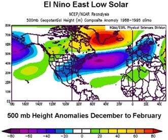
What about this winter? Well with a strong La Nina, cold PDO, warm Atlantic (AMO), QBO transitioning to westerly and a still low solar suggests the following.
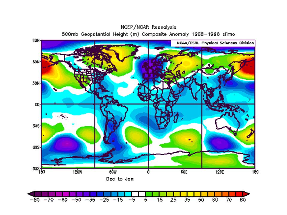
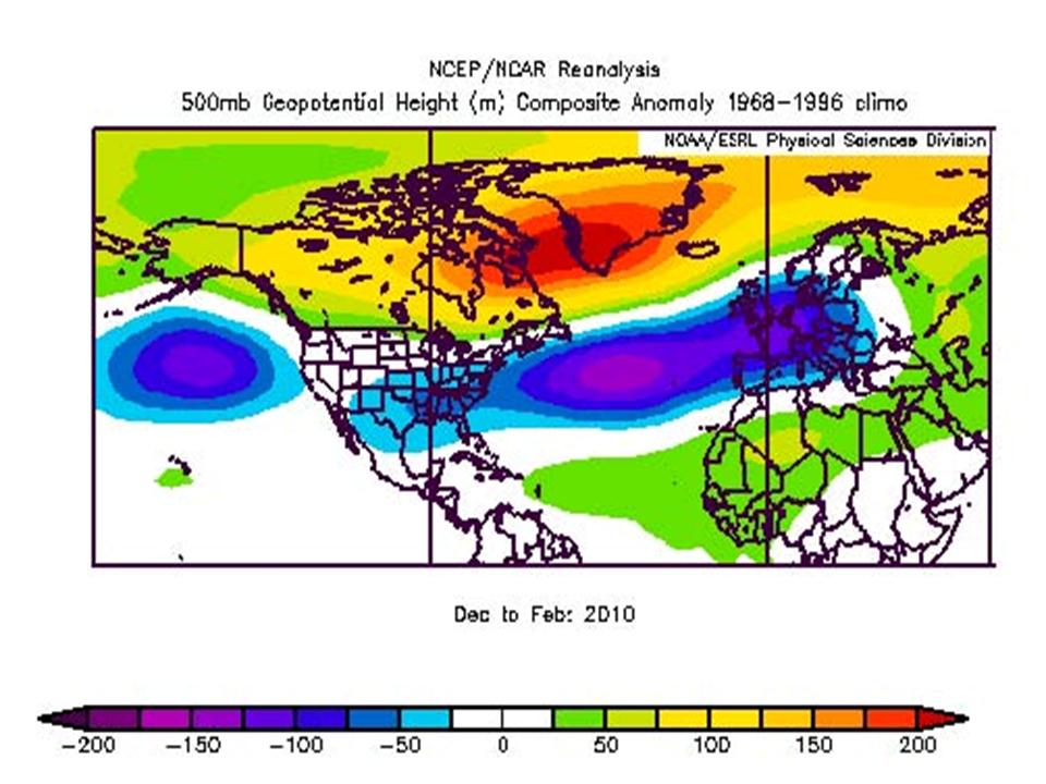
The 500mb geopotential height anomalies for the globe for December/January:
Enlarged here.
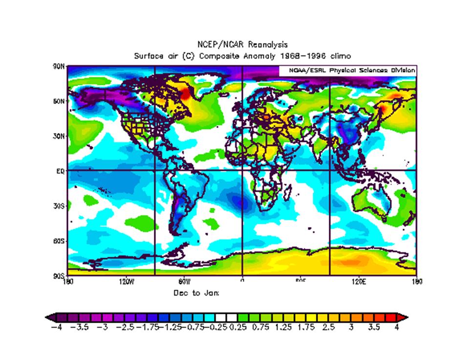
The surface temperature anomalies globally for December/January:
Enlarged here.
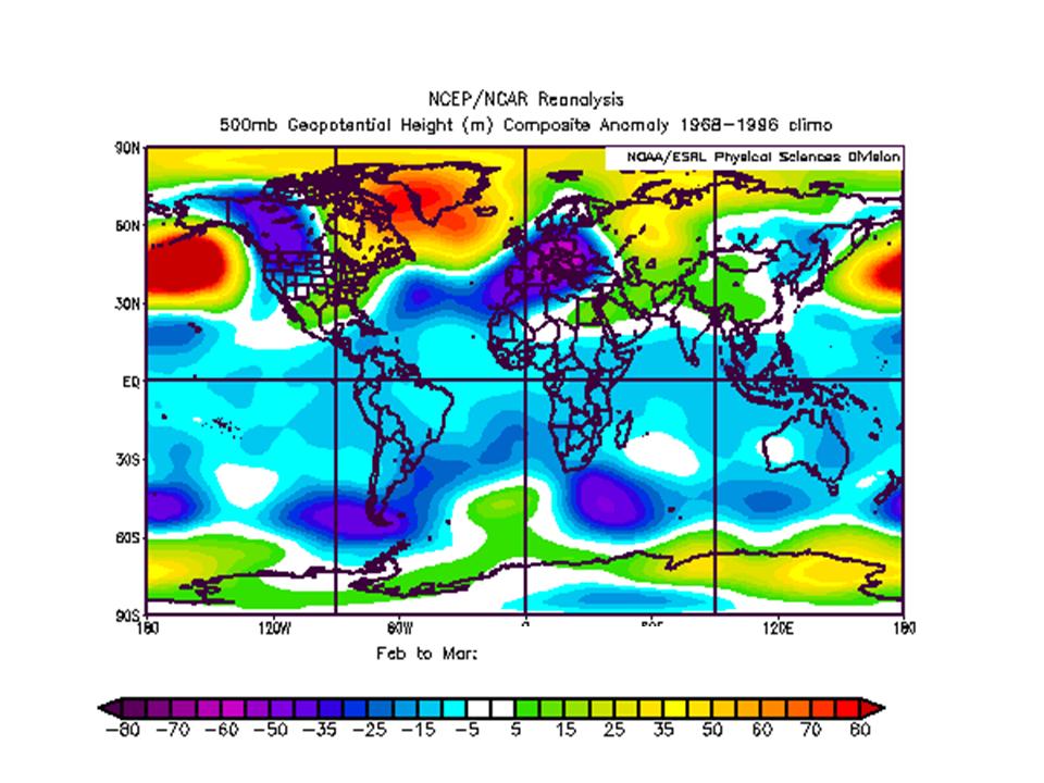
The 500 mb geopotential height anomaly for February/March:
Enlarged here.
The surface temperature anomaly for February/March:
Enlarged here.
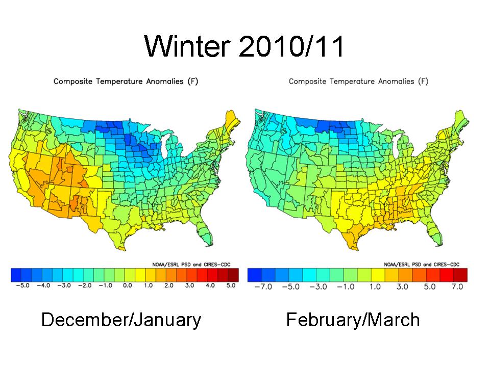
The winter (December/January and then February/March) for the United States:
Enlarged here.
For the US, this implies another cold winter for the upper Midwest, probably again heavy snows for the northwest, Rockies, Northern Plains, Midwest and northern New York and New England with ice storm threat(s) further south.
The same for Europe and western Asia:
Enlarged here.
This should mean more snow and cold for Great Britain and eventually much of Europe where they are getting used to weather more like the Dalton Minimum with snowy winters and long cold spells.
The winter should start out cold in central and eastern United States, Western Europe and China. A cool summer start seems in the cards for South America. The late winter looks very cold in Europe and western Asia, while the cold retreats west in the United States. Blocking in the Arctic/North Atlantic, last year at a 60 year record level, appears to be again a major factor.
If you ask does this approach work, see how it worked last year when in the fall we predicted this pattern (height anomalies which correspond to surface temperature anomalies) for the winter at 500mb (enlarged here):
This is what the 500mb anomalies actually looked like (enlarged here):
More to come. PDF
See Joe laminate floori’s take on it here. Joe nailed last winters heavy snow and cold in the south up to the Mid-Atlantic.
-
has anyone seen the winter discussion with the weathergeek predicting worst winter than last year and he has evidence to back it up if so what do you guys think off it and also there is a document on there stating polish weather experts says europe could have the worst winter in a millenuinm
hey where is that can u post the link so i can view intrested in weather geek he seems to be good also polish weather experts where the discussion
-
[thethe chart thats up here from last year and the one up now shows the gulf stream is allmost 90 percent less then it was
is this normal
does it happen from time to time this looks strange to me
-
check out this blog what do you think
-
theres more info here
http://pesn.com/2010/08/01/9501682_Gull_Loop_Current_Stalls_from_BP_Spill/
and lots of google about it and the sat images do show big changes
-
have a look at this site and this The North Atlantic Current is Gone
-
Go onto weather at the top of the screen, choose datacenter, pick the GFS, and from the drop down menu you pick a map of the Jetstream. Or you can go straight to the GFS here - http://www.netweathe...ab7dbdfabf8f348
hey yes i see the jet but looks like it allways did i mean before last year when it went south now it looks like its back where it allways was or am i wrong and its still south of uk and ireland just like winter 2009
-
Ok so where is the jetstream now is it still south of the uk and ireland or is it back up to where it allways was
sorry i dont know much about the jetstream
and how come we get no east winds i think the west winds are back to stay for the winter of 2011
 brrrrrrr


The North Atlantic Current Is Gone
in Spring Weather Discussion
Posted
How come we may only notice a change in winter why not summer too.
the Jet Stream may retreat further south in winter only why is that would it not be summer spring etc too would this mean more east winds in winter rather then sw