


Sun dog
-
Posts
78 -
Joined
-
Last visited
Content Type
Forums
Blogs
Gallery
Events
Learn About Weather and Meteorology
Community guides
Posts posted by Sun dog
-
-
Woken at 4am by torrential rain hammering the window. 7am spotted a break in the clouds and managed to get out with the owner just as the first rays of sunlight lit up the local woodland and it exploded into life. Amazing walk - towering cloudscapes, azure blue skies, crystal clear air and the heady scent of limes just coming into leaf. 45 minutes later and one of the darkest clouds I've ever seen appeared on the horizon. Made it back just as the downpour arrived.
-
 6
6
-
-
Frigid Great to see below average rainfall. Temperature probably swayed by cooler nights. In the sun should feel pleasant (glass half full)

-
2
-
-
Currently 16.2C in south Manchester and a gentle breeze - very pleasant. Sun trying to appear from behind the light cloud cover. Out with the dog at 7am with a t shirt and shorts. Expecting 18/19C before slightly cooler air arrives around mid-day.
-
6
-
-
Improved as the day has gone on. Strong breeze helping to blow the showers away.
Strangely reassuring to know the rest of the country is in the same boat
-
8
-
-
8.5C and spitting with light rain.
Nice 4 mile walk first thing - despite the rain. Amazing how the trees and hedges have greened up in the past couple of weeks. Large number of Blackcaps appear to have arrived overnight joining a couple from last week. Normally the majority tend to move on as the arrival of Spring continues to spread. Great to see a lone Sand Martin - only takes a couple of days of sunshine to bring the midges out.
-
6
-
-
Another fantastic start to the day. Hardly a cloud in the sky and for now not even a gentle breeze.
A couple of the local Barn Owl from 2 weeks ago. A huge conservation success largely down to one bloke who's
championed their recovery across the local area.
-
9
-
-
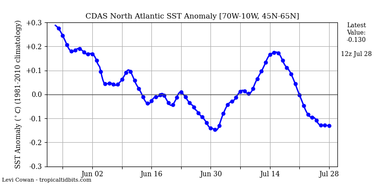
Looking on the bright side at least the SST anomaly is dropping. Hopefully a bit less moisture heading in our direction.

-
1
-
-
Surprisingly good start to the day. Blue skies and a few scattered clouds.Wind has eased off and in the more sheltered spots the warmth of the sun is really pleasant. Seemed to have had quite a few Springs recently that have been dominated by Greenland highs or other HLB that suddenly flip into summer. Perhaps this will be another.
-
5
-
-
Felt like the first day of Spring. 8C, reasonably sunny and a slight breeze from the SE. Great walking conditions and really good to see so many people enjoying a breath of fresh along the Mersey valley. Even spotted a weasel and had a go at the RSPB's garden birdwatch. Quite a few Snowdrops out and even a few of the weird red flowers on the Hazel.
After the deluge of last summer, autumn and early winter as long as it stays dry I can live with a lack of snow. I'm sure HLB will occur in late Feb and give us a few weeks of cool north-westerlys with a bit of snow on the hills and possibly the odd overnight surprise. The chances of any prolonged cold seems remote.
-
8
-
-
8.30am - out with the dog and a surprisingly bright start to the day. Even felt almost warm at a mighty 8C when the sun came out. Clouded over a bit more since and a very slight breeze is beginning to pick up.
Was hoping to get some more concrete around a fencepost that worked loose before Christmas but probably missed my chance - back to the steel wire guy lines.
-
7
-
-
32 minutes ago, James M said:
Well I think we’ve bottomed out at -10.4°C. Again we had that last minute drop just before sunrise, does anyone know why that happens?
Great question. I've often thought its due to air movement just before the "heat" of the day arrives but its a wild guess. There must be a scientific reason for it.
-
4
-
-
21 minutes ago, Dan B said:
Snow's come back harder here currently...
My feeble attempt before I got too cold

Will get the cars cleared and moved around after so the BMWs out to take me to hospital tomorrow; it's the car with winter tyres on thankfully!
Great snowman
My Granddaughter decided I needed to upgrade the car a couple of years ago. Not sure the Silver Lady fooled anyone.
-
6
-
-
- Popular Post
Still coming down in south Manchester.
A great early morning walk with the dog around Chorlton Water Park. About 3cm of snow.
-
13
-
6 hours ago, Snowmad79 said:
Despite the model thread meltdown in the last few days and having been on here model watching watching since 2007 I havent seen anything "special" from the models. A lot of people were hyping up a shabby long range retrogression of HP with no real Greenland high scenario which now appears to be getting watered down anyway. I personally dont really like Greenland HP because we more often than not in the NW end up dry and cold in a Nerly/ NEerly flow with all the goodies going down either side of us with the eastern coasts the most favourable locations.
Be interesting to see what the 12z models do with this HP.
Agree about Greenland HP. Normally rears its head in February and gives us a cold, miserable spring.
Just been looking at Met Office app. Heck of a build up on the model thread for a couple of frosty nights.
-
6
-
-
2 hours ago, Weather-history said:
Since and including Christmas Day, a staggering 91.9mm has been recorded for the region. That's slightly wetter than the equivalent period in 2015-16.
To put it into context, if next April was to record that amount of rain, it would the 12th wettest April on record for the region!
Surprising our region has escaped extensive flooding. The amount of rain seems comparable with last Feb and with the ground saturated I think we've been very fortunate.
It'd be interesting to know what's caused the deluge we've had over the past 6 months. We do seem to be in a cycle of weather patterns becoming stuck. Certainly frustrating when we're in a wet one!
Maybe I'm just getting old however I recall that for many years our dominant weather pattern was a westerly regime of troughs and ridges complete with crystal clear returning polar maritime air and the occasional high pressure. Since 2010 there does seem to have been a fundamental shift and the only reason I can think of is climate change.
-
8
-
-
6 minutes ago, northwestsnow said:
Happy with both. Still a bit more to go to reach 1947's 1060mb Arctic High

-
2
-
-
Just a quick reminder "The Big Snow of '47" Channel 5 @9pm tonight should be worth a watch.
Just been speaking to my parents about it. They're both in their mid 80's and can still remember walking to junior school through narrow paths cut into the banks of snow unable to see over the top of the drifts. With them both living in central Manchester - Crumpsall & Harpurhey, difficult to imagine what it must have been like. In comparison, their recollection of the winter of 62/63 is nowhere near as severe.
Can't help wondering if such an event is even possible nowadays. Although winters overall are warmer the frequency of 1 in 100 year events does seem to be increasing. Ultimately a freak event is a freak event - possibly the odds of a repeat haven't significantly changed?
-
7
-
 1
1
-
-
18 minutes ago, Spah1 said:
Been following the models and reading the Mad thread and it looks like a stupendously boring uk high. Bored with the whole saga.
As long as we get a break from the rain I'll be happy.
-
8
-
-
A few from 5th January 2010.
Shared album - Ian Worsley - Google Photos
PHOTOS.APP.GOO.GLAn interesting drive to work through south Manchester. Gave up with the parkway and ended up going through Stretford and Trafford Park before finding a jack-knifed HGV blocking Centenary Bridge. Yet another diversion up to Salford Quays and past a snowy Old Trafford.
Never occurred to me that it was a 1:20 year event.
Interesting to see what caused the snowfall. The chances of a repeat in January 2024 is looking slim
-
7
-
-
Time to take the dog out. Looks like I might have to put my coat on.
-
5
-
-
26 minutes ago, CreweCold said:
Bloody awful and damp here now
About the ‘rain shadow’ how come rain seems to get over it ok and we get drenched but snow is a no go?
Weird and sadly true. I'm sure there's a slight Foehn effect that kicks in when we have low pressure moving up from the south. A combination of the Pennines and Snowdonia kills our chances of a good dumping almost every time. Even when the precipitation does makes it over the hills it changes to rain, sleet and if we're really lucky - wet snow.
-
2
-
-
Currently on 34.1C. Sun has disappeared behind clouds and it actually feels cooler. A few high flying Swallows and the odd Swift around - normally a good indicator of a convergence zone. Nothing on the radar.
-
3
-
-
7 minutes ago, Cambrian said:
It’s always a fine line with lower Atlantic heights, but with the UK and Ireland under that continental wedge of heights, only neutral heights to the west of Iberia and a gentle southerly draw in all three models, along with the kind of summer we’ve had and its propensity for repeated patterns……
With so much heat bottled up to the south there doesn't appear to be anything to prevent a repeat of the existing pattern. Despite NOAA's forecast no sign of any ex TS injecting energy into a quiet Atlantic. Hard to see anything other than a repeat with plumes being increasingly restricted to southern areas and more northern areas the occasional deluge.
-
5
-
-
31.7c in south Manchester with rh at 36%. Feels steamier than yesterday with quite a few clouds beginning to build. Definitely one of the more memorable summers.
-
5
-


.jpg.3a92e70efa818220768be73337a49e23.jpg)


Northwest Weather Discussion - Dec 2023 onwards
in Northwest Weather Discussion
Posted
A cool breeze however the early morning cloud has broken up and the sun is shining. 12.3C in the shade and 15C in the sun. Surprised to see so much blue sky about. Hopefully a brighter day than forecasted.