


anvilhead
-
Posts
331 -
Joined
-
Last visited
Content Type
Forums
Blogs
Gallery
Events
Learn About Weather and Meteorology
Community guides
Posts posted by anvilhead
-
-
I have a feeling that the 700mb dry layer is making it up across cornwall as aposed to southern ireland - im probably completely wrong. That's a serious looking organised cell near penzance to my eye
-
what is it with us musicians and weather lol .. there must be some connection.
Agree there AJ lol - what is life if you dont have hope hey! actualy I remember not too long ago waking up in my sleepingbag in kent with my girlfriend ringing me in cirencester saying the mcs had gone 150 miles west and she was watching a light show .. you never know when we only have course model guidance to go on what may happen, however slim the chances are (I agree btw).
Sam
-
Hey Pat .. yeah I noticed those cells - by the feel of the weather here today I reckon the whole system has shifted east a couple of hunderd miles - strong cells were meant to be in southern Ireland at this point. I reckon they'll hit south wales and get an oragraphic boost .. you up for a chase ??
sam
-
is that some sort of meso low heading into south wales at the moment ? looks like it from the radar
-
Hey all.
GFS 12Z looks a bit better on meteociel (to my eye)- cape of 800kj by 14:00 (to the east of the cotswolds), and 1300kj by 17:00 (Near Norwhich way). Jet support is good, and there looks to be a convergence of surface winds across the spine of the country, moving slowly east as the trough approaches. Lift in the area of cape bullseyes for both periods at 700mb - The model does show precip breaking out, only getting its act together as it gets to the NE coast, but to me all our storm situations have one or two twists or turns before the event, so I'm personaly not ruling out strong storms and a bit of chasing sunday
 sam
sam -
dryline retreating and warm front shifting northwards - I hope that cell is reachable to the north -
-
as a laymans guess I'd say the cell to the west has more chance of riding the warm front (which looks to have retreated a bit) and producing a TN - just guessing though
-
I hope the action doesnt kick off too far west from the team - looks interesting on cam right now though
-
Stunning webcam right now :unsure:
.. that gunk to the south might affect inflow though - we'll see hey -
that feed is supeb. Great view of the cell just now - come on team!
-
Here's mine:
April & May: Extreme troughing initialy over, then to the west of the uk - drawing up southerlys with a powerful jet stream aloft. Temps rising to 24c and some intense hail storms and long lasting storm modes
June & July: 2 months of glorious high pressure, being broken every 10 days or so after increasing humidity and temps rising to 32c by day - 22c at night, by intense strobing night time thunderstorms, then the heat building back in.
August: A powerful ex hurricane sits out to the west of Ireland, pumping extreme moisture over us - heat and humidity interspersed with absolute downpours. A couple of long track supercells moving SW to NE across the country dropping tornadoes and baseball size hail on a couple of saturdays .. huge forum convergence.
Winter 2010: Coupled with extremely cold uppers, magma mysteriousely breaks the crust just below the waterline in a 30 mile long, 10 mile wide swathe of the Bristol Channel SW'wards - the convection resulting from the steam creates a standing supercell with an anvil stretching for 300 miles, hailstones the size of basketballs, lightning 10 times per second.
Not much to ask is it ?
-
I can confirm that Coast - I live in Cerney bizarly ..got about an inch here but its heavy
-
thats gotta be a trough on the back of the front there -
-
thats a mesmerising radar..
could be the best part of this cold spell coming up for us (I'm in Cirencester) - gfs shows temps not getting above freezing tomorrow and thursday, with -10c at night & thursday night!
-
NAE has that lp down to 962mb oat 48 hours! .. ukmo 970mb, gfs 978mb ..
-
Good call TC re the line loosing intensity
-
Just had a covering here - very heavy for a while
The NAE shows a blizzard for tuesday, with 2m temps holding nicely - the ukmo absorbs the low and brings in mild, both the GFS and ecm slide it to our SW, keeping us in a cold SE'ly. My money is on the second solution given GFS's consistency in recent runs and agreement with the european model. We'll see hey..
Interesting times!
-
I can see that precip pepping up for this area - gfs shows moderate 700mb vv at 9pm over this area - by midnight theres no lift (IMBY Cirencester) so then we'd be looking for orographic lift to kick off showers only imo, but we'll see - i'd imagine this paramaters not so acurate on a global model like the gfs anyway..
-
eeyup. I just looked at the radar
That lot heading west looks like its intensifying doesnt it ? - can anyone give a quick summary of whats forecast pls ? -
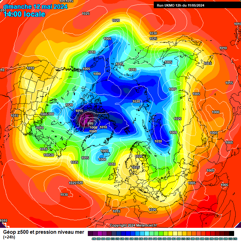
I'm not so sure though a reload is on the cards for a considerable amount of time- the NH lowest heights seem to go into a stage of retracting and consolidating towards the pole and rosby waves get a shift on in the normal direction. The High seems to hold on for a while and there are signs of continued low heights in the med and trough disruption/absorbtion out over the atlantic, but I dont see the pv playing ball to the NE of the high for quite some time & this I believe will eventualy shunt the high east if things stay out of phase..
gfs:
http://91.121.94.83/modeles/gfs/run/gfsnh-0-24.png?12
http://91.121.94.83/modeles/gfs/run/gfsnh-0-60.png?12
http://91.121.94.83/modeles/gfs/run/gfsnh-0-84.png?12
http://91.121.94.83/modeles/gfs/run/gfsnh-0-120.png?12
http://91.121.94.83/modeles/gfs/run/gfsnh-0-168.png?12
ukmo:
http://www.meteociel.fr/ukmo/run/UN24-21.GIF
http://www.meteociel.fr/ukmo/run/UN60-21.GIF
-
yer its like being in space...
lol - dont - I just got vertigo
-
12Z gfs for cirencester (imby I know) - gives a good indication of how gfs is handling european boundary temps imo
sunday 1pm 850temp -9c 2Mtemp 0c
monday 1pm 850temp -6c 2Mtemp 0c
tuesday 1pm 850temp -0c 2Mtemp 0c
wednesday 1pm 850temp -0c 2Mtemp -2c
thursday 1pm 850temp -0c 2Mtemp 0c
friday 1pm 850temp -2c 2Mtemp -1
shows any flow with a remotely south east component will be darn cold ... although this run is favourable for lp tracks. I wonder what precip type will fall with uppers of 0c .. snow, snow pellets, or supercooled rain ?
sam
-
GFS 12z for cirencester:
Monday Midday: 1c (Winds Easterly)
Tuesday Midday: 1c (Winds SEasterly)
Wednesday Midday: 1c (Winds ESEasterly)
Thursday Midday: 1c (Winds Easterly)
Friday Midday: 0c (Winds Northerly)
Friday Midnight -2c (-10 in wales) (Winds Col)
GFS's been moving towards bringing down temps over the last 3 runs - disrupting the trough and sending a low into the med -
While I dont use the gfs as gospel, and other models right now show more displacement of the high to the east and milder temps moving in, but its not written in stone. I think only a fetch not from the SE will give us any breakdown in the cold right now due to the cold continent- my money is on a disrupting trough, and SE'ly to Easterly throughout next week, although I personaly want an end to this cold!
 sam
sam .. that gunk to the south might affect inflow though - we'll see hey

 That lot heading west looks like its intensifying doesnt it ? - can anyone give a quick summary of whats forecast pls ?
General Storm Discussion Thread
in Storms & Severe Weather
Posted
is that a spilt cold front on the analysys ? http://www.netweather.tv/index.cgi?action=charts;type=fax;sess=