


North East Blizzard
-
Posts
208 -
Joined
-
Last visited
Content Type
Forums
Blogs
Gallery
Events
Learn About Weather and Meteorology
Community guides
Posts posted by North East Blizzard
-
-
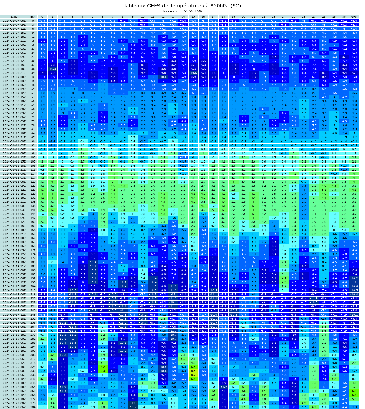
Mo-greps latest 850's out to pretty much the 20th. London and Newcastle.
Staying cold throughout up North, slight warm up down south before it drops off again.

-
 3
3
-
-
22 minutes ago, winterof79 said:
Houston please disregard our last communication

Do you have a link to these charts please?
-
1 minute ago, swfc said:
I can't find the control on the gfs 12z on metiociel???
Download the app

-
1
-
 1
1
-
-
Can't remember seeing a mean 2m temp of pretty much zero degrees, over such a long period of time in my neck of the woods, since I started model watching. Incredible really.
Some ridiculously cold members in there. GFS and GEM ensembles paint a similar picture

-
6
-
-
Worth a share.
-
7
-
-
Not sure how this isn't named, some very strong gusts forecast for my post code, slightly higher elsewhere too.

-
2
-
-
29 minutes ago, kold weather said:
A Dudley level storm normally hits Scotland/north every season, possibly a couple of times a season in more active years. Its nothing too out of the ordinary, though of course it does merit warnings clearly.
Eunice as it is *currently* modelled is significantly more unusual. When your talking of possible 70-80mph gusts into densely populated areas that get those sorts of winds every 5-10 years or so, thats very media worthy and people do need to be given quite obvious media warnings, particularly given the area is just not used to those sorts of winds as you say.
Anyway still quite a few runs to go on the models and small shifts will make significant differences in terms of strength and location of strongest winds.
We've already had a storm like that up here, and another not far behind, a friend lost his whole roof and has been living in a hotel since, 1000's of trees down throughout the North East, and many buildings devastated A red warning was issued for the November storm, I guess because it didn't affect large swathes is the reason it didn't make many headlines at the time, but some were without power for quite a considerable amount of time.
-
2
-
-
Hope all you guys down there stay safe. We have had our fill of storms up here recently, any more damage could be devastating for businesses etc, glad this one is giving us a wide birth. Just the snow to contend with this time.
-
Marco Pertangas reaction to the 12z would give me the impression they or at least Marco himself prefer the Ecm, Ukmo over Mogreps, for now anyway
-
6
-
-
34 minutes ago, P-M said:
It is but it stretches miles inland too. So Sunderland right on the coast yes I'd expect but places further inland I was curious. Newcastle is few miles inland and Washington where I am part of Sunderland but about 7 miles as the crow flies inland.
I can't recall seeing charts like this for low lying areas this close to a wind event it's crazy.
Yeah, I'm 43 and can't remember winds of this strength coming from the North before. Going to be a crazy night up here. Stay safe.
-
2 minutes ago, P-M said:
Morning MWB,
How far inland would you say the strong winds will get? Are we looking at mainly those right on the coast or some a few miles inland? I'm just thinking populated cities like Newcastle and Sunderland for the NE etc and the likes of Edinburgh.
Looking at those charts I'd take a bet that those winds upto 80mph+ will have an impact a little way inland too.
Sunderland is pretty much on the coast tbh, only a couple of miles, if that away. Dangerous situation for sure.
-
1
-
-
Interesting forecast here, going for below average for the UK.
https://www.weer.nl/nieuws/2021/vroege-winterverwachting-koud-en-droog
-
2
-
1
-
-
15 minutes ago, geordiekev said:
Showers look more sporadic but beefier for those that catch them
Yep, just having the heaviest shower of the whole spell, its dropped at least a cm, probably more, seriously heavy stuff
-
10 minutes ago, untiedshoes said:
I would imagine they will be difficult. Wife came home from work last night, and they'd had a couple on inches. I'll be taking here up around 08:30, so will let you know
Its pretty hairy
-
8
-
-
36 minutes ago, untiedshoes said:
Sat24 has been showing showers out to sea for the past few days - once they start getting close to shore, they start to dissipate unfortunately - unless it's the Scottish coast .
They certainly weren't forming that far out as shown above, there was a mass of cloud covering a huge part of the North sea hindering shower development, that looks nothing like yesterdays Sat24
-
1
-
-
4 minutes ago, tynevalleysnow said:
Sat24 showing showers forming out to sea which should hit Tyneside this afternoon!
Actually that looks rather promising, looks like there's a long line of showers starting off quite far out.
-
4 minutes ago, Tucka20 said:
I know i'm being negative and this is IMBY but those streamers again look to be placed ideally for Northumberland and Teeside, with little to nothing for Tyne & Wear & Co Durham. With regard to new warning, yep no showers at all forecast for Whickham or Stanley on their own website Thurs-Fri.
We will maybe get the odd one, but really we are waiting for the wind direction to change more North easterly. I'm nit going to pay much attention till later on this afternoon
-
4 minutes ago, Smoggieontour said:
Another one heading your way now mate.
Showers are a little bit longer lasting compared to yesterday, had a couple of half decent ones this morning.
Those should be ours tonight
-
Looking at the mass of showers up in Northumberland and out to sea, if we still see those there in the evening, then i think we'll be in business further south. Met office backs this up, light showers all day then as soon as the wind changes direction the forecast changes to heavy snow.
-
1
-
-
9 minutes ago, garylaverick said:
Trying to salvage some positivity, winds swinging round to the NE noticeably in to the late evening with multiple areas of convergence.
Really positive about tonight, originally Met had us down for light showers and clear spells, now has snow for all with limited clear spells. That sounds to me like a more compact area of showers.
-
Had a much better night here, all tracks covered up, probs 3 or 4 inches or so.
Matt Hugo has the North east down as prime area from the early hours tomorrow morning, fingers crossed.
-
6 minutes ago, NickR said:
OK, so that's Consett in June. What about a winter one?
Haha, tbh I've just moved nearer to Shotley bridge than Consett. It's not even bad up there currently, main roads all clear, estates aren't great though.
-
If you catch one, they are extremely heavy now
-
3
-
-
Wind direction has changed slightly here, showers coming in more easterly than before when it was a slightly more north easterly, typical as it meant a massive blob that looked destined to hit, skirted by
Anyway, updated fax looks interesting
-
2
-

.png.371f1ddeeff6083cb9365e8159229bb7.png)


Model Output Discussion - Colder but how cold and for how long?
in Forecast Model Discussion
Posted
Beat me to it