


DTHFCJ
-
Posts
954 -
Joined
-
Last visited
Content Type
Forums
Blogs
Gallery
Events
Learn About Weather and Meteorology
Community guides
Posts posted by DTHFCJ
-
-
SK
*** N.B. - the last point may be open to changes/completely fictitious
That Sir is quality

so it seems the back end of winter could throw up some of the white stuff again for some,the last few years,well since 2007 things seem to have changed poorer summers and whiter winters......i wonder if this summer will buck the trend following on from another at times white(ish) winter (for some)..........
-
I live practically right on the M4 so I never really know where I stand!
As long as its not in the fast lane!
-
Warning though - don't take precip signal too literally. My gut feeling is this could result in a snow north of M4 gig, at least until backwash returns southwards with colder flow into early Monday (and how this phases with actual ppn amounts is anyone's guess). We're still miles away from any certainty. It could yet manifest a very marginal event for much of W Country, depending on shape/depth of the low, the track, and how it entrains the colder E/NE tuck later phased with ppn and WBFL (the latter looking like a steep and knife-edge gradient across the south by 00z Monday).
it makes you wonder sometimes was the M4 purposely built for snow events
-
Hi Ian. What are the symbols that are a circle with a little dash? Look a bit like an on/off symbol on a tv etc. Thank you.
Sorry, just seen above reply to this exact question. Being picky I noticed one right at the end of the channel in this area
it means get back to TWO!
-
I did as the forecaster said and googled:
Reading throught that link.."the more significant the SSW the more likely it is to have an impact at the surface and also the greater the potential impact"......reading on "meto office observations systems have picked up a minor SSW...equating to just a wobble in the flow........
-
Which day was the "epic" ECM easterly run from last week?
Pretty sure it was 5 december..........(wednesday)
-
Because guys we will be saying the same stuff come January ' oh it's only January 8 weeks left yet!' It needs to be happening now. Not always in a few weeks etc...
Dont often post in here but read the thread(s) every day,from what i gather there could be something special on the horizon..there are some members on here with excellent input others who are trying and others who are learning..reading posts from experienced members should fill you Adam with plenty of hope,it does me..
-
excellent GP,good luck and i bet you wont be far off with all of it... and an early one for you "Happy Christmas"
-
nice looking ECM...............192 onwards sign of things to come maybe?
http://www.wetterzentrale.de/pics/Recm1921.gif
-
http://www.meteo.psu.edu/%7Egadomski/ECMWF_12z/test8.gif
cheers Active Weather Dude
-
-
wish i could post the 500mbr height anomaly charts...they look pretty good to me regarding fine decent weather...i know they are just one tool but ive been looking at these for some time , just wondered the opinion of more experienced posters?
-
Certainly some unstable weather looking more likely as we go into the new week with the approach of very moist TM air coming up against the warmth of the last few days.
The developing extensive upper trough over the Siberian side of the Arctic looks like a notable feature for the next 10days or so locking in the heights over Europe and holding the core of the Atlantic trough just to our west.
Here the height anomls. at T192hrs from the mean 00z outputs.
All pretty much show the same pattern as described above.
For the UK we do have a cooler week ahead of us with some rain and possible thundery outbreaks but later on towards the weekend those thickness look like rising further south and east as the influence of the Euro. high shows it`s hand..
We can see this from the 2 thickness images from the ECM means at T72hrs and then at T192hrs.
the Atlantic trough losing it`s sharpness and filling.
Of course details of day to day conditions can`t be ascertained beyond the next 2-3 days but the way the sypnotics are shapiing up we should see things gradually settling down somewhat further south with the more unsettled weather retreating to the north west in week 2.
excellent post there Phil,also looking at the NAEFS all summer like Nick has said they are better than they have been,also the 500mbr height anomaly charts dont look to bad compared to what we have seen
-
Yes, very much so. Although we were just starting to sniff another little coup, and the ensemble means were swinging 'our' way, along came freaky friday and the whole pattern got yanked back a thousand miles and set us on course for next weeks upper trough. The ensemble mean products have us a sharp trough days 6 through 10, steadily lifting out thereafter.
If there is one area I would look at the longer range offerings tonight, it would probably be around Scandinavia - heights not high enough in the models if we begin to see angular momentum shifting us towards a weak El Nino state.
Sorry for going slightly off topic but thanks GP for your honesty...at least you admit things when they dont go to plan(which of course is no fault of yours)...keep up the good work
-
Looking into the medium term and without going into the merits of individual runs the general trend has been to place the core of the Heights just to our west and in the Atlantic. later next week and up to 10 days ahead.
Yes there has been some changes in details between runs but a look at the 00z ECM/GFS 500hPa means show a very similar picture in the overall 500hPa pattern, such as i have outlined.
Last nights NOAA 8-14day hts anom went with this idea too
http://www.cpc.ncep....14day/500mb.php
This may allow some influence from the Scandinavian trough further east from time to time if we get enough energy over the top of the High.At this distance we can`t know how that will pan out.
At this stage though it`s not bad an outlook compared to what this Summer has dished out so far.
Excellent post Phil and like you rightly say compared to what this summer has been so far....
-
Looing at the next week or so
Yes Nick the developing Scandi trough modelled for later next week is also shown on the 00z NAEF`s and in it`s later frames the blue anom.eventually envelops the UK pushing the High pressure well away into the mid Atlantic.It`s some time away but needs watching.
Meanwhile just looking ahead towards the next week, we have a couple more days of this current unsettled weather to get through before the low and it`s fronts finally move away.
We then see the first visit of the ridging Azores High for some considerable time.
Here the fax for Sat.midday.
something of a rarity this Summer so far and it should give much of the UK a fine Saturday and this heralds the start of a much drier and brighter week for much of England and Wales although there will areas of cloud around in a generally Westerly flow.
The Ens.Graph here.
Scotland and N.Ireland will still see some less settled periods with the Low pressure tracking towards Iceland and the attendant fronts moving across from time to time.
We can see from the ECMT144hrs chart how the track of the next low is further north reflecting the realignment of the jet.
So a much more typical UK Summer pattern looks like setting up from the weekend then-at least for a few days.
As usual we will see something of a NW/SE variety of weather with a much better outlook for those further south in the UK next week. It looks like becoming quite warm for a short while the emphasis is on something less settled with rain at times further north -more especially the far north and west of Scotland and N.Ireland.The more sheltered south and east of Scotland would some decent weather at times i would think.
looking at the NAEFS Phil, last night the blues did envelope the uk todays are better and not so pronounced?and further away from us..
-
I think there are reasons to be more optimistic that we that we will start to evolve into a more traditional Summer Westerly pattern next week.This would allow some respite from this protracted cool and wet spell at last-especially further south and east.
We can see on these NAO forecasts from the GFS/ECM 00z ens outputs that the pressure anomols. go from weakly negative now to a forecast of slightly positive next week.
Looking at the 00z mean hts for days 8-10 and the NOAA 8-14 anomol. charts show at last some orange areas-high pressure- moving in to the UK from the South West.
What i like is this T180hrs mean 500hPa chart from the 006z GFS showing the collapsing of Greenland heights next week which up to now has kept that jet stream well south and straight across the UK.
This development seems the trigger to draw those heights from the Azores High north eastwards towards the south of the UK further into week 2.
Southern,Central and South Eastern parts of the UK would fare better at least with some fine and warm days later next week if this pattern change verified.
However the unsettled conditions would still affect areas further north at times with frontal systems moving in from the Atlantic over the top of the High pressure further south.
So something more like Summer for some but not yet for all it seems as we get that North West /South East split so often seen where we have a flat Azores High not quite ridging far enough north to affect the whole of the UK.
Let`s hope that will come a bit further down the line.
I see that tonights NOAA is even better to Phil...would post the link but im naff with that sort of thing maybe someone could post it?
-
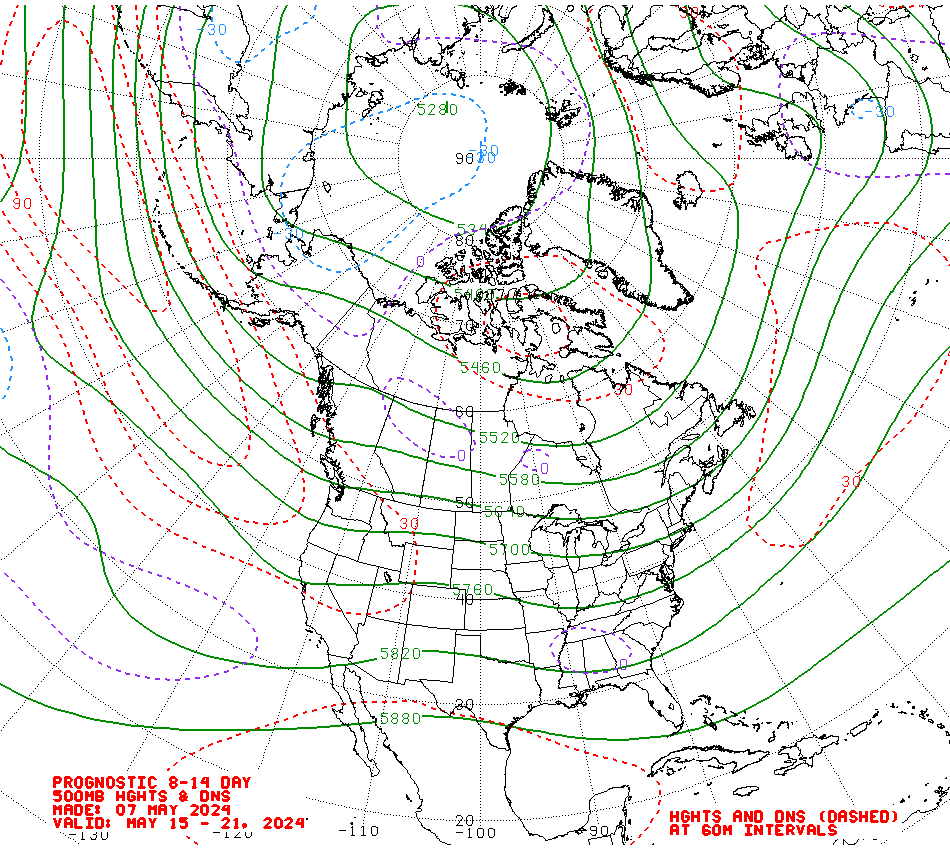
http://www.cpc.ncep....y/814day.03.gif
may not look like much but its sooooo long since noaa cpc have shown a surface high in our vicinity it just had to be linked to !!
agree ive been looking at them charts for weeks and thats the best ive seen for along time....you have to look at the bigger picture more and not just the ops is what im slowly learning
-
Looks to me as if the ridge across the south this weekend is becoming increasingly tenuous on GFS, with UKMO having none of it and keeping LP in charge.
Hopefully GFS will not back down any farther, I'd like at least a half decent day on Saturday for Yeovilton Air Day, but the current trend is not a good one. Looking beyond that, there's still little or no hope of a protracted fine, warm and settled spell, but at least things do not looks as bad as during the first half of June, so I guess it's all relative.
Cant seem to work the MO charts out,just read the extended outlook and the weekend sounds pretty good the further south and east you are..yet the output looks pretty dire..going by the ops
-
Yet the MO looks alot different @ 120 even more@144
-
Hey all,
My model based video musing today is looking at the chance of an improvement in the weather beyond ten days (so from around 17th-20th)
All very tentative though.
cheers Gavin....easily understandable for everyone from the knowledgeable to the novices
-
i can see the 12z
edit apologies i totally misunderstood didnt read properly thought people meant the 12z ops....too much sun today
-
That Sir was a quality post..(Jack Wales)
-
after a run of poor summers my gut tells me..so nothing scientific,this summer will be..cracker


Spring Model Discussion 21st March 2013 006z onwards...
in Spring Weather Discussion
Posted
Northern blocking gone?
http://www.meteo.psu.edu/~fxg1/ECMWF_0z/test8.gif
or am i reading the charts totally wrong...