


bryan629
-
Posts
665 -
Joined
-
Last visited
Content Type
Forums
Blogs
Gallery
Events
Learn About Weather and Meteorology
Community guides
Posts posted by bryan629
-
-
- Popular Post
- Popular Post
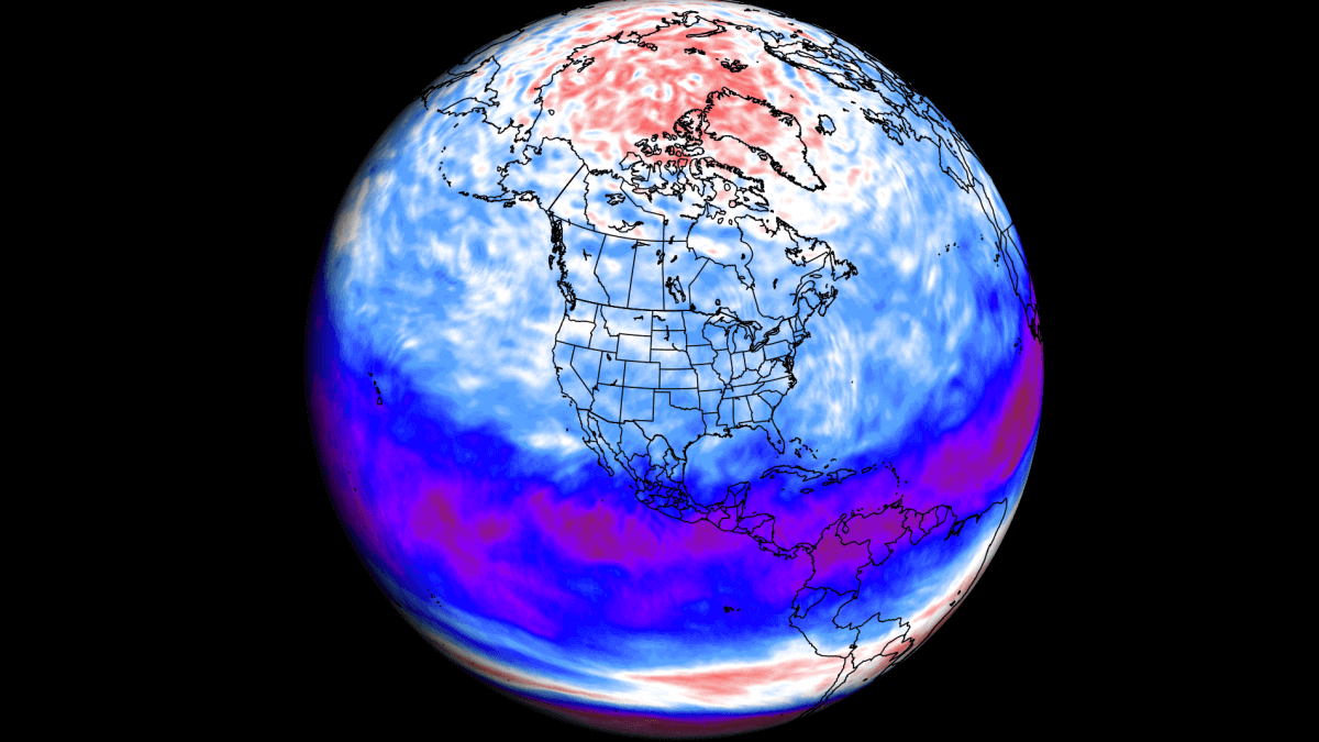
8 minutes ago, Mike Poole said:Strat vortex pretty much annihilated T276 on GFS:

This is part and parcel of what is going on now, not just a harbinger of the future in my opinion.
Also a good visualization of what a split SPV looks like
-
 12
12
-
 2
2
-
 2
2
-
AO literally falls off a cliff!!
-
4
-
-
Cracking pub run... since modelling watching from 2011 i dont think i have ever seen a black hole as significsnt as this before

-
5
-
-
3 minutes ago, Allseasons-Si said:
EPS mean out to 264 so far,i thought the day ten was good


control.
Control is Epic.. High speed cross polar flow inbound !!
-
2
-
-
- Popular Post
- Popular Post
Gem/CMC Control , wow!!!
widespread snow for everyone if this verifies .
Shame its not in the reliable at 192 hahaha
-
10
-
GFS whips up a hoolie next Thursday... !!!
-
Gem control way out at 8th Jan goes for a split SPV
-
7
-
-
-
5
-
-
So just for fun i decided to peer deeply into the muddy waters of the netweather crystal ball , which also has a good smattering of tea leaves for good measure!
Something caught my eye this morning from the GFS way out in neverland to something i saw on X yesterday, so i put A+B together and arrived more than likely at Z ,
First off is the MJO prediction for late october and early november:
HP dominated wesern europe which seems to drift northeast over to Scandi.
Then as mentioned the GFS late OCT Early NOV
So nothing particularly striking about these charts, unless you like a south easterly. I just found it uncanny that yesterdays MJO prediction looks a lot like the GFS 00z
Absolutely not wheeling out the `P` word at all.. and all just for fun, so nobody needs to wake Nick Sussex just yet.

-
5
-
-
What does Judah mean by "Interesting but on an Island" . Do you think he means the ECM is a bit out of kilter.
-
1
-
-
With some references today talking of " Water Vapour " in the strat. Im assuming this Vapour would actually be ice crystals being so high up. Do the weather ballons measure the ice crystals.
I was also wondering about the Antarctic polar vortex and if was stronger and faster spinning than normal or slower and weaker? might give us an idea if and how all the WV may impact on our SPV this year.
Loving the cansips update BTW ,but how come they are smoothed out to the point there is no sign anywhere of the trop PV on them?
-
35 minutes ago, RainAllNight said:
That tropical storm is enough of a thing to show up as an ensemble mean anomaly at T+240 now.
What's the name of this one, anyone know?
This one will be namd Margot.
Incidentally , met office reporting warmest day of the year just now.
-
1
-
6
-
-
- Popular Post
A plume of elevated Saharan Dust currently seen in satellite imagery heading for the SW UK and Ireland this evening, and then continues further N for Tuesday evening. Potential for some spectacular sunrises / sunsets this week.
-
20
-
4
-
1
-
15 minutes ago, Ben Sainsbury said:
Correct. Warm-cored system, developing over SSTs of ~27C.
To make matters funnier too, what looks to be a tropical system, possibly hurricane, heading east towards Portugal at T276.
Yes.. looks like the 6z following GEFS 0z control... obviously a long way off and nothing guaranteed. Seems to follow the coastline. Great for surfers at Lazarous i expect, or insane!! Maybe Tamaras watching and breathing a sigh of relief

-
Is this the definition of a medicane ?
-
1
-
-
At least cansips is sticking to its guns ( June and July editions)
-
3
-
-
OMG!! thought we were done for today.. a few bright flahes here.. loud bangs.. gets up to check radar.. mental!! Where did all this come from ?
-
Recretos published this earlier discussing the relationship with an El Nino and an EQBO this coming winter
A Stratospheric wind anomaly is developing over the Equator, expected to impact the Weather along the El Nino in the next Winter Season » Severe Weather Europe
WWW.SEVERE-WEATHER.EUWinter Weather in the United States, Canada and Europe will be influenced by the changing wind anomalies in the Stratosphere over the Tropics-
2
-
1
-
-
Cloud cleared up nicely today inland..about flippin time too. Looking at this satellite loop cloud in the North Sea looks to be very thin, if not a lot drier air as well. So hopefully if it does move inland again tonight it should break dead quick tomorrow morning.. hope the east coast gets to enjoy some decent sunny spells as well. Looking forward to a warm/Very warm weekend now.
-
1
-
-
I see the navgem wants to send a profuse apology to us by next Saturday to make up for the naff teperatures endured down the eastern half of the UK this week gone.
-
8
-
-
1 hour ago, mushymanrob said:
Yes, you correctly called that... despite what all indications were suggesting

It is still astonishing that CPC are adamant about a regressing HP despite all the other overwhelming evidence of an easterly progressing HP .. even the discussion on their website states above average chance of that 4 out of 5 .
I suspect a change in their anomoly charts fairly soon.
Thank you @Tamara too, brilliant insight that the NWP were barking up the wrong tree and hope you have a great summer !
-
3
-
-
Finally!! A bulls eye thunderstorm over Ripon.. it is absolutley epic.. Packed with lightening and thunder , still making a racket even though its moved off east.
Torrential rain as well :)
-
3
-
-
4 hours ago, NeeNar said:
Spent all night pulling people out of snow and getting them to safety, time for a snooze now. Was out between 0100-0700, A59 between Skipton amd Harrogate was measuring 40-50cm on the road at that time at high points, drifting higher than that. We had to use service 4x4s rather than actual fire engines because of road conditions.
I was meant to travel the A59 from about 8am to get to Keighley from Ripon. I had a feeling it would be bad on that road, specially the winding steep inclination to the top from Swinsty reservoir..then even if that was managed the long run over the moors to Beamsley hill.. i reckoned it would be really bad up there so just cancelled my appointments.
I just want to say a really big thank you to people like you whom rise well above and beyond the call of duty and serve the public the wat you do .. Thank you

-
1
-
-
4 minutes ago, DevinW said:
Hello, long time lurker here. I Have been overlooking this forum for over a year now and with this upcoming snow event I couldn't handle the excitement and just had to join
 Hoping this snow finally delivers something here, I don't think we have seen snow around here since late 2021!
Hi Devin, happy to see you and hope you like what you read.. Middleton is quite high up and usually does well when it snows compared to lower parts of leeds. hope you have a sledge ready for Miggy hill
-
1
-
1
-


.gif.4dff05061ab3cceb8f1c6b33d02ee2d5.gif)

Model Output Discussion - Spring Has Sprung
in Forecast Model Discussion
Posted · Edited by bryan629
Well this is all very interesting,
looks like a massive hit on the PV to me
Definately easterly winds here
Signs of a split going on lower down as well ... GFS control 12z showed that up nicely!!