


FrenchScotPilot1
-
Posts
121 -
Joined
-
Last visited
Content Type
Forums
Blogs
Gallery
Events
Learn About Weather and Meteorology
Community guides
Posts posted by FrenchScotPilot1
-
-
Yes I sometimes wonder about their criteria too.
Unless, it is to cover themselves just in case...
-
Please could we stop this North/South bias stuff right now?
All I know is that when I've got something planned — like a longish car journey, it always snows somewhere along the route causing anxiety or problems, but when I've gone up to the loft to get the toboggan out with nothing more in mind than a lovely day playing in the snow, we get nowt or it melts.
Sod's Law rules.
The thing that should also be stopped is what people WANT.
I know it is a natural human behaviour but weather will happen regardless of Andy being fed up with cold and snow in Scotland or Paddy wanting snow for the first time this winter in his back garden in Ireland!
I'd rather read informed opinions of what might happen based on model outputs.
Rant over

-
Snow warnings for Scotland back up... http://www.metoffice.gov.uk/weather/uk/uk_forecast_warnings.html?day=1
-
No weather warning doesn't mean no heavy snow, it just may not be considered sufficient for a warning.
Indeed, MetO use a likelihood/risk matrix: is it going to happen and if so, what are the impacts?
-
most of the snow showers will be convective though will they not?
Showers are always of convective nature. Question is: will it be convective snow or front snow?
-
Tell me BBC Scotland are wrong.They are now saying they don't think the snow will get as far north as Scotland on Friday. This is news to me!
High pressure to our N could stall the fronts further S indeed.
-
I think you are right Pilot, the prolonged reversal of zonal winds following the warming producing an extended lag effect into the troposphere. Whilst the SSW did not fit exactly with the Cohen climatology paper, I think in large part the events unfolding can be worked back to the SSW. The effects not happening sooner in my opinion a result of that fragment of vortex parking itself over NE Canada, once it dissipated then bingo.. Look where we are. One for the review of the Winter - when it ends !
The AO has barely been positive at all this year and the NAO has often been negative as of late too. Fascinating effects.
Thanks for the clarification lorenzo!
-
NAE getting closer to giving us some insight, 12z runs and this evenings 18z should ensure a rammy on the model thread relating to the positioning of the front.
That cold pool over the North Sea looking fairly substantial now, certainly not a quick dilution for any front approaching the freezer door.
Couple of other charts for the relevant time frame, the GFS 850 potential equivalent chart gives a good impression of the cold in place.
Also this for the start of next week from the ECM, brrrr. Pretty amazing chart worth putting away for posterity. One would imagine you would not see a similar chart for a fair few years.
Snow cover intact here, still wispy light snow falling here. An ensemble run that refuses to return to above 0 degrees for the entire run on the 00z and hovers are around the -10 until a week on Friday. Exceptional.
I blame the SSW
-
NAO maintaining negative values. Could be that the Greenland high slipping SE'wards would stall the week end fronts further south. Very interesting to follow either way.
-
NAO maintaining negative values. Could be that the Greenland high slipping SE'wards would stall the week end fronts further south. Very interesting to follow either way.
-
From my perspective the output is win win if you like cold - if it reaches us we get a hell of a blizzard but if it doesn't we stay in sub -8C uppers with winds from the east so a similar setup to what we had yesterday evening.
I know I've probably learned this lesson before but fronts and easterly winds are not a good mix under ANY circumstances for the east coast or low lying areas within 10-15 miles of the east coast. The precipitation from the fronts tends to be overdone, as much as the convective stuff tends to be underdone in fact, and that leads to a build up of expectations which is almost never met. The best thing that can happen when encountered with one is to have a relatively quick encounter on its northernmost edge so that the effects are relatively minimal and we can get back to the nice convective stuff.
In the end it was the showers which delivered the most as always, and not the front that the MO put out the orange warning for, which I think is why I had a bad feeling about the warning - they tend to only be put out for frontal stuff since the MO usually miss the convective potential and being in the frontal zone tends to lead to disappointment.
Now why is frontal worse than convection when dealing with a maritime flow?
1. For convection to occur in winter with SSTs relatively low in the North Sea the upper air temperatures must be pretty damned cold by definition to sustain it. This also leads to the nice effect that, in general, the heavier the showers the colder the airmass. However, with fronts uppers can be anything you like and in fact the strongest fronts have more pronounced warm sectors, with those which don't being fairly weak.
2. Convection gives you clearances between showers, which in the middle of winter during the day and at all times at night causes the temperature to drop away. The absolute worst condition assuming an all snow event at night is either very light or non existent precipitation coming from a large organised cloud bank. Temperatures are held up by the cloud cover but without the redeeming feature of the heavier precipitation to bring temperatures down towards the dew point.
3. The airmass changes significantly. Whereas before you were looking at a nice clean cut Arctic Continental airmass being slightly modified by the North Sea you're now talking about an almost entirely modified airmass with a 'dynamic' rather than convectional skew-t. On the ground this means that, whereas before on the coast you were looking at very low dewpoints with slightly higher DPs inland where temperatures were lower and precipitation more intense (and hence higher humidity) you're now talking about a base level humidity of around 90%. After 10pm last night most of the east coast south of Dundee was reporting DPs above 0C and for most of today almost all locations in central or eastern Scotland had DPs above 0C in spite of the low temperatures. This has a very dramatic effect on the ground conditions, turning the most pristine snow to slush and stopping any further snow accumulation even in spite of relatively high intensity snowfall. DPs above 0C can be countered if they are temporary, temperatures are 1C or lower and there's limited mixing but if not things just start to become very damp.
4. Temperatures will always be held above 0C no matter what until it clears, barring exceptionally cold starting conditions AND limited wind speeds. In December 2009 and January 2010 we saw a few quasi-frontal events during the great cold trough period and after, but crucially wind direction was not due east for the most part. The one event we did have with easterly winds and a front early on the 2nd January was very close to a disaster near the coast for snow cover, with temperatures going from -10C widely to 1-2C in a matter of a few hours and snow from the front itself failing to lie. This was with uppers around -6/-7C and wind which was not exactly strong. However what followed behind was a fantastic spell of convectional snow with a classic Forth-Clyde streamer event, leading to the now definitive -8C rule, which for convective snowfall remains a kilted thread absolute for forecast guidance (Shuggee must take a large part of the credit for this monumental discovery during 2009/10).
5. Convective snowfalls are often just as good for the west coast as frontal snowfalls from the east. Ayrshire was reporting lying snow last night from the initial northeasterly convective stuff and Lanarkshire has on numerous occasions been utterly pasted by nothing more than a North Sea snow blower. With frontal snow marginality is often absolute and not just confined to the immediate coast because conditions under the blanket are generally much more homogenous than the localised immediate North Sea marginality.
Also, you're now speaking to the new secretary of EUSNA (or Edinburgh uni SNA as it's now officially unofficially known) so you know who to talk to for all your Edinburgh Uni nationalist needs
What a fountain of knowledge! Very good post.
Could you please elaborate a little on the end of point 4 (-8 rule) if you have time.
Thanks
-
Well we've had cloud but no signs of further snow whatever after that shower about 8.30am; even some bright/sunny spells now occasionally poking through! Something's amber, but it ain't a warning!! Clouds don't look ready to dump anything!
Frequent snow showers in Dyce all morning. Radar shows a bit of an accalmy for now.
-
i see u got my link.
your far better in here than the model thread as it can get confusing in there with them always talking about england.
Yes thanks. There is a great level of experience and knowledge over there but it is annoying because everything is to do with England!
-
No snow in Glasgow. Nothing. Not a flake.
Too far inland for showers to reach with an E'ly flow. Better with NW'lies.
-
What's an appropriate word 'better' than Fantasy Island?
-
Fantasy Island...
Aaaaaah ok! It all make sense now. Thanks!!
Moderators can delete if needed.
-
Sorry guys, I've tried to work it out but I failed miserably. What does FI mean?
-
have a look at the skew-t diagrams for the area you are interested in is my suggestion-honestly never used rule of thumb for convection as I have always had access to either t-phi's or skew-t diagrams
hope that helps?
Will do. Thanks for the wealth of knowledge John.
-
The North Sea is pretty cold at the moment (about 5 degrees). See http://ghrsst-pp.metoffice.com/pages/latest_analysis/sst_monitor/ostia/index.html?i=34&j=2
But the 850 hPa air forecast to cross it is expected to be around -15 degrees.
My question is: what value of temperature gradient (SST-850 hPa) do you use for effective convection? This is about 20 degrees in this case.
Obviously, it also needs moisture for showers.
Many thanks for some pointers,
Stephane
-
Thanks SK: the fact that the PV has already been disrupted is enough to displace surface HP and LP from their usual positions.
All clear.
FSP
-
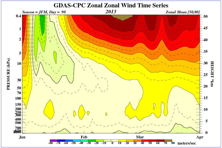
It looks like the polar vortex is reforming at higher levels as indicated by the mean zonal winds on the ECM at T+0:
http://wekuw.met.fu-berlin.de/~Aktuell/strat-www/wdiag/eczm.php?alert=1&forecast=a12&var=u&lng=eng
And:
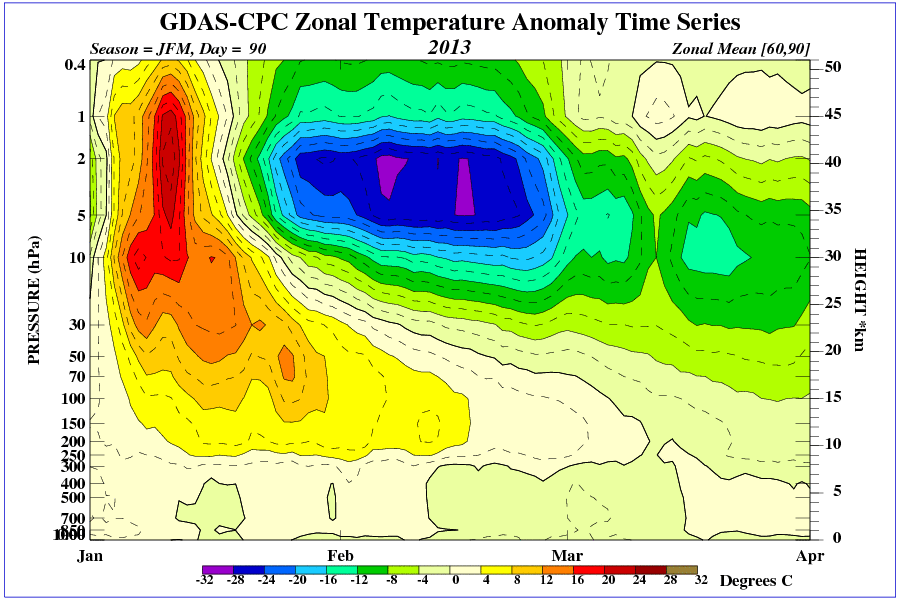
Higher stratosphere is currently colder than average and the opposite is true for the lower stratosphere, with the recent warming downwelling:
I know it is far in the future and at a less reliable level but a ridge is shown to build at 100 hPa on the ECM (T+240) :
The GFS supported the idea until T+204:
http://www.netweather.tv/secure/cgi-bin/premium.pl?action=gfs;sess=e715497de74cb61e04244e54cfe63354
But the pattern seems to flatten out after this. Wishful thinking...
Anyway guys, your contributions have been invaluable to increase our understanding of the phenomena.
Thank you very much!
Stephane
-
Once again, very good post chiono!
Would it be fair to say that the cold snowy event we're experiencing just now is a result of the first strat warming that happened at the start of Dec '12?
Thanks,
Stephane
-
Almost 100 pages. And VERY good, informative posts. Thanks for the contributions guys. Keep them coming.
Stephane
-
 2
2
-
-
- Popular Post
- Popular Post
Here's a picture of nacreous clouds last night over Scotland:
-
13


Scotland Regional Discussion 17th March 2013 18:30>
in Regional
Posted
Surface pressure charts show an occluded front ahead of the warm front. That would explain the 2 bands.