


Skin
-
Posts
43 -
Joined
-
Last visited
Content Type
Forums
Blogs
Gallery
Events
Learn About Weather and Meteorology
Community guides
Posts posted by Skin
-
-
The reason behind the odd QBO locking in earlier this year was due to the strong el Nino event. That explains a lot, actually.
In the ensemble with observed SSTs we find a strong and significant alignment of the ensemble members in the equatorial stratospheric winds in the 2 to 4 years after the strong ENSO event in 1997. This alignment also includes the observed QBO. No such alignment is found in the ensemble with climatological SSTs. These results indicate that strong warm ENSO events can lock the phase of the QBO.
http://onlinelibrary.wiley.com/doi/10.1002/2016GL070751/abstract
-
 7
7
-
-
On 12/3/2015, 6:03:24, s4lancia said:
Intriguing! Especially considering (I would have thought) that the current Enso state coupled with this W-QBO would have produced this response for early December anyway? Interesting to think that another primary driver might be at play here.
The state of the PDO is helping negate the ENSO signals. Which I think allows the SSWEs to take precedence this winter.
Positive PDO blocks or interferes with the propagation of the ENSO signal through the extratropics-
3
-
-
Table 2, has 7 different SSW definitions. Look at how unsure we are about what constitutes as a SSW. Hopefully the WMO will get the point we need a set one definition. whatever it is. From this paper.
-
5
-
-
Got some information straight from NOAA and AMS regarding the current strat situation. Basically just reiterating what we already know, NOT a major SSW and will try to classify as a Minor SSW.
Today's Topics:
1. Re: Wave-2 stratospheric warming to usher in the New Year!
(Amy Butler - NOAA Affiliate)
----------------------------------------------------------------------
Message: 1
Date: Fri, 9 Jan 2015 12:32:30 -0700
From: Amy Butler - NOAA Affiliate <amy.butler@noaa.gov>
To: strat_list@nwra.com
Subject: Re: [strat_list] Wave-2 stratospheric warming to usher in the
New Year!
Message-ID:
<CAEPbyeM5sdsZdCoXe0cT+dTn0=2+F9RNwVEPjW4KdjCV=w5q=A@mail.gmail.com>
Content-Type: text/plain; charset="utf-8"
Thanks, Paul.
As we have been discussing this last week at the AMS meeting, while the
vortex did split and the temperature gradient reversed over the polar cap,
a reversal of the zonal circulation did not occur at the 10 hPa level
anywhere equatorward of 70N, so this event will not be classified as a
major event by the current criteria at 10 hPa and 60N.
We'll also use this opportunity as a plug for our current efforts
associated with SPARC in updating the standard SSW definition. Some of
these efforts include defining minor warmings such as this one more
clearly. More information can be found at our new email list (subscribe on
the left hand side): https://sites.google.com/site/stratosphericwarmings/
We had an interesting group discussion at AMS and will have at least one
other at the EGU General Assembly this spring in Vienna (possibly also at
IUGG and/or AOGS) and hope to see you all at one of these gatherings.
Cheers,
Amy Butler
Ed Gerber
Dann Mitchell
------------------------------
----------------------------------------
Message: 1
Date: Tue, 30 Dec 2014 14:52:53 -0500
From: "Paul A. Newman" <Paul.A.Newman@nasa.gov>
To: <strat_list@nwra.com>
Subject: [strat_list] Wave-2 stratospheric warming to usher in the New
Year!
Message-ID: <A47F2125-B25B-4DAF-8FA6-E5FB0E261BE0@nasa.gov>
Content-Type: text/plain; charset="windows-1252"
Hey All,
There is a wave-2 warming that is developing. Should be maximizing around
Jan. 3.
See http://acdb-ext.gsfc.nasa.gov/Data_services/arctic/ for maps.
Yours, Paul
Dr. Paul A. Newman
Code 610.0 NASA/GSFC Greenbelt, MD 20771
ph: (301) 614-5985 fx: x-5903
http://acdb-ext.gsfc.nasa.gov/People/Newman/
?The race may not always be to the swift nor the victory to the strong, but
that's how you bet? - D. Runyon-
2
-
-
Meanwhile, the US is getting bombarded with brutal cold air. I suspect this warming in the stratosphere and split PVs played a higher role than most realize.
-
1
-
-
Berlin model is acting strange. not sure whats going on. Goes from a split PV at 10hpa at 00hr

To a reformed PV 24 hours later.
Am I missing something?
-
I'm all ready struggling with how the strat affects the troposphere in terms of predictability. Can you explain how the MJO has this effect on the strat and it's follow on potential repercussions at a lower level? I'm just trying to get a handle on this.
The MJO effects the planetary waves, which can propagate poleward, depending on the phase, the waves form and the potential heat is there waiting to effect the strat level. That is how I perceive it to work. anybody can interject, please do. this is my 3rd year following so I am not the expert on this still.
-
Trouble is a trend without a theory is just data mining potentially. Still has not stopped the masses in the financial worlds believe in chartism.
Makes me think the signal is MJO related.
-
1
-
-
Just something I noticed. There is a pattern of warming every 4-5 weeks, it seems once we get to the strat season. So just extrapolating, the next one would be end of Jan, beginning of Feb. gaining more heat each time.
-
4
-
-
Don't know whether this is stratosphere related, but are there signs of the QBO trending westerly by the middle of next year?
Yeah qbo data on Berlin shows. Westerly qbo starting at upper stratosphere. Now. Would take several months to peak at 20mb level.
-
http://users.met.fu-berlin.de/~Aktuell/strat-www/wdiag/ts.php?plot=temps&alert=1&lng=eng
The temperature spike is pretty significant, to me should be enough to be a sudden stratosphere WARMING event. 25° difference in a matter of days. Do we even have a clear definition of a SSW yet?
-
4
-
-
Too popular for your own good Recretos - drop box 509 - This account's public links are generating too much traffic and have been temporarily disabled!
I have to say I think your 3 D representations of the Polar Vortex are worthy of the Turner Prize!!
Yeah i 2nd that. the 3D models are unreal and unique to this thread. I hope you are patenting your software.
-
4
-
-
Concerned over the MJO projections. Dies into the Circle of Death right as it nears Phase 7.
-
1
-
-
By definition, are we seeing a Canadian warming? Only seen a few papers talking about it. Guess it depends on who's definition you use. Lol!
http://birner.atmos.colostate.edu/papers/Butleretal_BAMS2014_submit.pdf
Canadian warmings (early winter warmings marked by a poleward shift of the Aleutian high)But different studies implement these classifications in different ways. For example, some studies (e.g., Charlton and Polvani 2007) classify Canadian warmings as major warmings if a circulation reversal occurs, while others (Labitzke 1977) argue against this based on differences in synoptic development.-
1
-
-
Sorry,whats the above showing Skin?
Thanks in advance.
warm Temp anomalies already appearing on several levels of the Strat. Will it be strong enough? thats the kicker.
-
-
Wave 1 activity is forecast to back off, but its still strong even at that. 2200 m/s to 1600 m/s at the upper strats. but definitely Wave2 is going to take over. Definitely reminds you of 2009 this time of year.
-
5
-
-
"The QBO is measured at 30 hPa and has entered an easterly phase for this winter. "
It's in the first (excellent) post on this thread.
Believe me, I thought it was 30mb too. maybe because its in the middle of it all is why they use 30mb. Why not take the average of the data points from http://www.geo.fu-berlin.de/met/ag/strat/produkte/qbo/qbo.dat
-
Confused about what QBO phase we are in. The Holton 1980 paper defines it at the 50mb level. http://www.atmos.washington.edu/gcg/JR_site/papers/1980_6.pdf
And looking at the current chart. we are at the value of 31 (positive)
http://www.geo.fu-berlin.de/met/ag/strat/produkte/qbo/qbo.dat
-
2
-
-
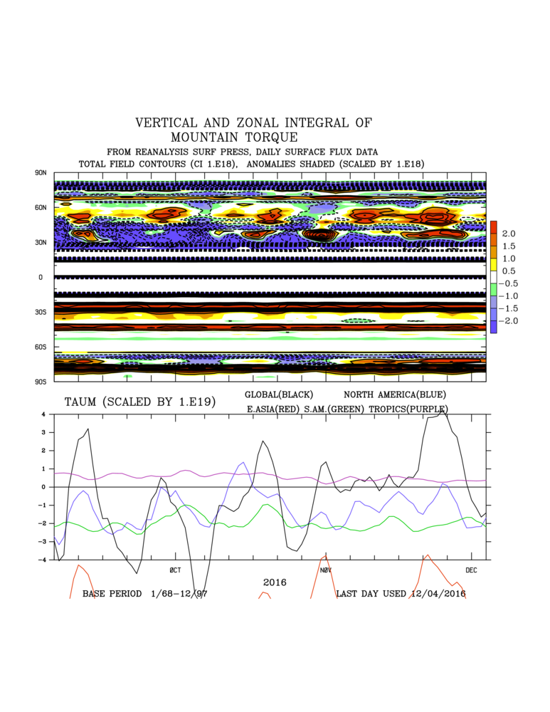
Looks like all the AAM and Mountain Torque data had a seizure.
http://www.esrl.noaa.gov/psd/map/clim/aam.90day.total.shtml
Mountain Torque:
http://www.esrl.noaa.gov/psd/map/images/reanalysis/aam_total/gltaum.90day.png
-
1
-
-
- Popular Post
- Popular Post
Looking forward to reading all of your posts, everyone! This has been a go-to thread for much of my understanding of SSWs. 3rd Winter with you guys and cant be more excited!
PS: Can this thread also cater to United States folks as well? the internet knows no boundaries haha. Maybe include some updates as to what both sides of the pond can expect.
-
12
-
The Last 2 GFS runs are showing a full recovery of the +zonalwinds, Recretos, by the weekend.
It does kinda appear to be the case tho. Looking at GFS/GEFS recent scenarios, there is no way that the vortex can recover back to the extent that the zonal mean zonal component would be positive in the mid-upper strat.
And the entire globe, and the south pole strat, that is way underway into the next cold season.
Note: The max/min data is for the global scale. Best regards.
-
The latest GFS runs were a variation on the same theme: a recovery of the vortex in combination with warming in the Asian sector.
Good too see EC with simalar warmings at the end of the run. Could this grow into a potent wave-1 attack?
Last chart of this 00z run.Looks like the beginnings of a true SSW.
-
4
-
-
Solar flux is around 240, what a luck. After such a long time of less activity, righ now, on the right moment, the sun gets more active. Our chances for a SSW increase! http://solarham.net/regions.htm
Can we really use this as a tool? r=.48 doesnt stand out to me as important. As much as I love solar weather ( I run Accuweather Astronomy Facebook page) I Would like to see higher r squared.


Stratosphere temperature watch - 2016/17
in Spring Weather Discussion
Posted
Doesn't last. http://www.cpc.ncep.noaa.gov/products/precip/CWlink/blocking/real_time_nh/mrf3.nh.shtml