


Paul
-
Posts
12,373 -
Joined
-
Days Won
53
Content Type
Forums
Blogs
Gallery
Events
Learn About Weather and Meteorology
Community guides
Posts posted by Paul
-
-
In anticipation of some wintry later, please post your reports here <_<
-
Please post your weather reports here

-
Thanks John, certainly is looking like a pretty stormy 24 hours....
-
Please post your snow/wintry precip reports here
-
Please post your reports here
-
Snow showers started about 18:30 in Aviemore - Now Near Tomintoul and heavy frequent snow showers with drifting in the strong wnw wind. Was wet snow at first but now below freezing and any slush has frozen , Cant give a depth as too blowy! Looks like a trough moving into the west on the radar too ! let it snow let it .......
-
Snow now being reported by belfast airport.
-
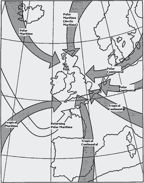
The main Air Masses that affect the United Kingdom
Air Masses are defined as a large body of air (covering many thousands of square kilometers) which at any given level has almost uniform temperatures, lapse rates(see topic on this), and humidity.
Their Source Regions are large areas of the earth where air often stagnates for long periods. Examples of these are the Polar Regions, and the sub tropics. Air over any of these regions may stay for long periods and thus picks up the characteristics of the land or sea beneath it.
When, because of a pressure gradient (see another topic on this) an air mass moves from its source, its properties will be modified by the land or sea over which it travels. By following the isobars on a pressure chart we can identify where this air mass has come from.
Air Masses are classified by reference to the area they have come from and their subsequent track. In the UK they are known as either POLAR or TROPICAL, depending on where the airmass originated from, and are then sub divided into MARITIME or CONTINENTAL depending on whether the air has passed over land or sea.
There are four major types that affect the UK
Polar Maritime (Pm)
Tropical Maritime (Tm)
Tropical Continental (Tc)
Polar Continental (Pc)
Below is a diagram showing these four major air masses as they approach the UK. One has not been mentioned so far, that is Returning Polar Maritime (shown as a paler colour and approaching the UK from the sw). This is Polar Maritime air which has dome a long sweep over to the south west and is now returning with Tropical Maritime characteristics at the surface.
Without going into a lot of detail the 4 air mass types can be summarized this way.
Polar Maritime (Pm)
In winter this will give convective type cloud with showers, often on windward coasts and hills. Depending on how cold the air is then snow, soft hail and sleet are likely. The showers can extend well inland by day but as the land cools at night the showers become mostly confined to the coastal belt. If troughs form in this air mass then showers can continue into the night and become much more widespread, especially if a Polar low forms (read up on separate section for Polar lows)
In Summer then it is the inland areas that get most shower activity due to the land heating more than the sea. Coastal strips may be shower free but inland showers or thunderstorms can develop.
Another version of this is called Arctic Maritime (Am)). As the map shows this comes direct from the Arctic and is thus even colder and therefore more showery than the Pm, This may well allow marked troughs to develop as it comes south over warmer seas, possibly even a Polar Low(see article on these)
Tropical Maritime (Tm)
It starts off from its source warm, moist and just a shallow layer. As it moves towards us it picks up more moisture, its cooled from below by the sea becoming colder as it moves north. On arrival here, usually into the southwest it has an overcast layer of Stratus and Stratocumulus (see cloud information section) and gives drizzle with extensive hill fog and sometimes coastal fog also.
In winter these conditions can spread well inland with ground temperatures being low, especially at night. If it is associated with frontal weather then coming over a cold, maybe frozen ground then advection fog (see fog section) can set in with the thaw. It can sometimes to the east of high ground, with a Fohn effect(see section on special winds) give better visibility and higher cloud bases than in the west.
In summer , particularly during the afternoon this Fohn effect combines with the warmer land to produce good cloud breaks well inland and only shallow Cumulus or Stratocumulus.
Tropical Continental (Tc)
Starting out from its source as dry, hot and at times hazy. On arrival in the UK it is stable, usually with no cloud, and is either hazy or becomes hazy if this persists for several days. Often it is the hottest air mass for these islands, especially the south and south east.
In winter if this airmass reaches us then it has the characteristics of a short sea track Polar Continental due to it crossing the cold land mass of France.
Polar Continental (Pc)
This may have started over Russia or Scandinavia. In each case its precise track will have a great bearing on what weather it gives.
Taking the winter situation first.
It sets off very cold and dry. If its track is across Europe and then from the Low Countries into south east England then it picks up very little moisture. The weather is usually dry, hazy and very cold with severe night frosts. If its track takes it across the North Sea (often having originated from Scandinavia) then it picks up moisture off the sea, this is also much warmer than the air moving over it. The net result is that the bottom of the atmosphere becomes what we call unstable (see section on Stability and Instability) and large convection clouds develop (Cumulonimbus or Cumulus=again see section on clouds). This causes showers, usually wintry, even possibly with thunder and can give appreciable snowfall in eastern districts, being especially pronounced on the eastern slopes of hills.
In Summer with a short sea track it is often dry and very warm (due in part to the long hours of daylight in high latitudes. So only limited Cumulus and possibly hazy if the situation lasts for any length of time.
With a long sea track it has become stable due its passage over a relatively cold North Sea, and it gives overcast conditions with possibly drizzle and poor visibility, maybe even fog along the coasts. This can extend well inland during the evening. It has similar characteristics on the eastern side to those of Tropical Maritime along southern and western coasts.
Finally to Returning Polar Maritime (RPm)
It starts life in cold areas, maybe off Greenland is the most likely. It then moves south, possibly south east for a time and then swings in towards the UK from the south west. What happens to it during its journey is quite complex. First, as it heads southwards, it is heated strongly from the increasingly warm sea, this makes it unstable. Its moisture content is increased. Then as it moves north east it is cooled from below, so becoming stable in its lowest layers, and it continues to pick up more moisture.
So when it arrives in the south west (its usual entry point) it has broken or overcast low cloud with hill and coastal fog, along with drizzle.
In summer as it moves inland then the heating effect returns it to its original type (POLAR MARITIME) and convective cloud develops giving showers or thunderstorms.
This topic has several links, some of which are already available on the Net Weather Guides; some are yet to be put together. One topic which follows on from this is the development of Fronts and Frontal Depressions. I hope to be able to post this in the not too distant future.
John Holmes
-
Weather Alert
Category: Level 3 Warning
Weather type: Freezing Rain and Snow
Affecting: Northern England, The Midlands, Wales
Date Valid For: 11:00 Monday 20th December - 18:00 Monday 20th December 2004
Time Of Issue: 12.25 Monday 20th December 2004.
A band or rain and snow is now moving from the West across many parts of Northern England, Wales and The Midlands. This will continue to do so througout the rest of the afternoon. A period of snow is likely in many places, particularly over higher ground where a covering of upto 10cm's is possible.
The snow will turn back to rain eventually.
Drivers and pedestrians should take extra care if venturing out as conditions may become very icy indeed.
Confidence Level: 80%
Note: This alert should be considered a guide and we strongly recommend you stay tuned to the Met-Office for further warnings and updates.
Expect further updates as and when is necessary.
Disclaimer: The owners of net-weather.co.uk hold no responsibility for losses or damage to property or injury to persons due to any information or forecasts contained in this website. The application of any of the information or forecasts within this site are entirely at the users risk. The information and forecasts held on this website and any services linked with the website are provided on an as is basis, the owners of net-weather hold no responsibility for losses or damage to property or injury to persons due to any of these being unavailable at any time.
-
Please post your reports here
-
Weather Alert
Category: Level 3 Warning
Weather type: Heavy Rain, Gales & Sleet/Snow
Affecting: Midlands, Southwest England, South Wales, the West Country, Central Southern and Southeast England.
Date Valid For: 12:00 Saturday 18th December - 06:00 Sunday 19th December 2004
Time Of Issue: 15.35 Friday 17th December 2004.
A band of rain, together with strong winds approaching 60 MPH in places, will push eastwards across the southern half of England and Wales. The highest likelihood of disruption due to strong winds is through the Home Counties.
The rain is likely to turn to snow over the Midlands and central Wales, mainly but not only over high ground, with accumulations of 5-10cm likely above about 200m. As the rain clears south-east, there may be some snowfall over high ground in the south on its back edge, with accumulations possible over the Chilterns and Downs.
Confidence Level: 70%
Note: This alert should be considered a guide and we strongly recommend you stay tuned to the Met-Office for further warnings and updates.
Expect further updates as and when is necessary.
Disclaimer: The owners of net-weather.co.uk hold no responsibility for losses or damage to property or injury to persons due to any information or forecasts contained in this website. The application of any of the information or forecasts within this site are entirely at the users risk. The information and forecasts held on this website and any services linked with the website are provided on an as is basis, the owners of net-weather hold no responsibility for losses or damage to property or injury to persons due to any of these being unavailable at any time.
-
The NAO-- whats it all about and why is it important.......
For those who don't know what those "Highs" and "Lows" stand for on the charts here is a brief description of them..
Air pressure is a measure of how much air is pushing down on the surface of the Earth at a given point. Generally, high- and low-pressure systems form when air mass and temperature differences between the surface of the Earth and the upper atmosphere create vertical currents. In a low-pressure system, these vertical winds travel upwards and suck air away from the surface of the Earth like a giant vacuum cleaner, decreasing the air pressure above the ground or sea. This decrease in surface air pressure in turn causes atmospheric currents moving parallel to the surface of the Earth near the base of the low to spin counter clockwise (clockwise in the Southern Hemisphere). Conversely, in a high-pressure system, air is being pushed down on the ground like a vacuum put in reverse. The downward vertical winds cause an increase in air pressure on the ground and force atmospheric currents to spin clockwise (counter clockwise in the Southern Hemisphere). Both lows and highs function like giant slow-moving hurricanes and anti-cyclones, respectively. The higher in pressure a high-pressure system gets or the lower in pressure a low-pressure system gets, the more robust and larger this spinning circulation pattern becomes.
A low pressure system will pull in air from the surrounding area. Winds around a low spiral counter-clockwise (in the Northern Hemisphere, clockwise in the Southern Hemisphere) and upwards towards the centre of the system
Air is pushed away from a high pressure system. The winds rotate clockwise (in the Northern Hemisphere, counter-clockwise in the Southern Hemisphere) and away from the system's centre
In terms of the NAO
A permanent low-pressure system exists over Greenland and Iceland, and a permanent high-pressure system exists over a group of islands roughly 900 miles (1400 kilometers) west of Portugal, known as the Azores. For most of the year, the high and the low are mild, and their influence on the Atlantic basin climate is minimal. When winter hits, however, all of this begins to change. Both pressure systems grow much more intense and begin to fluctuate from week to week between two different states. In one state, which scientists call a positive NAO, the high-pressure system grows especially high, while the low-pressure system grows especially low, creating a large pressure difference between the Azores and Iceland. In the other state, known as a negative NAO, the high-pressure system weakens and the low becomes shallow, creating a milder pressure difference between the two regions of the Atlantic. As the low and high intensify and relax, the winds revolving around their centers increase and decrease in both strength and in extent. During a strong positive NAO, the two pressure systems can just about cause all the currents in the northern half of the northern Atlantic to spin counterclockwise and all those currents in the southern half to spin clockwise.
Here Illustrated below is the 2 MAIN states of the NAO ( The third being neutral..)
What it all means to us......
A positive NAO on average can increase rainfall in northern Europe by a little over an eighth of an inch per day and warm the air there by roughly 5 degrees Fahrenheit (2.8 degrees Celsius). If the condition persists for most of the winter, it can lengthen the growing season by 20 days in Sweden, lower reindeer populations in Norway.
A negative NAO, on the other hand, will bring rain to southern Europe, drop the temperatures in northern Europe, and maintain the already warm climate across the Mediterranean. If the negative state persists, it will increase the production of olives and grapes in Greece, , and create ideal skiing conditions in Austria.
The PNA or Pacific North American Pattern is characterized by atmospheric flow in which the west coast of North America is out of phase with the Eastern Pacific and Southeast United States. It tends to be most pronounced in the winter months.
There can be 3 defined states of the PNA- rather like the NAO- We have Positive, Negative and Neutral.
When we are in a neutral phase or a 'High index' Phase of the jet stream the typical west to east flow of Low pressure systems remains largly Un-interupted- ( this pattern is generally I 'Think' indicitive of a global high index phase)..
When in either a Strong positive or negative phase this has dramatic effects on the weather type distribution of the continent of the USA,and ultimately A FINGER in the 'Pie' of the weather type over the British Aisles....
The 2 main states of the PNA here demonstrated below-
In a positive phase ( Demonstarted in the image below) we have a mild western ridge and a cold eastern trough, the net result is the whole of the Eastern Seaboard is plunged into a colder winter with Artic air being dragged south and then south east out of Central Canada-
Above we have the October to January departures from normal of temperatures. Temperatures were as much as 3 degrees above normal near the ridge in parts of the west and 3 degrees below normal in the trough in parts of the east.......
Another Sypnotic illustration of the Positive PNA pattern here just shows how much of an influence over the Eastern Seaboard the PNA is...
ABOVE This pattern is delivering a series of bitter arctic cold air masses, with the greatest impact in the north central and northeast states. Meanwhile, the subtropical jet stream is again increasing. The increased subtropical jet stream will be the conveyor belt for the southern low-pressure systems that can deliver heavy precipitation (rains and snows).
The total Link between the PNA and NAO / our weather cannot be summed up as When the PNA is positive the UK is mild etc as- as we have all found there can still be inconsistencies...
We do however know that in a Positive Phase the energy that is thrown into the jet stream from the extreme cold streaming off the eastern seaboard does encourage 'DEEP" cyclogenesis- and I 'Think' this is where we can begin to make a few tentative links-
From my own observations-
* When we have a positive Phase of the PNA and the NAO stays positive a VERY strong period of Zonal weather is Likely for the british Aisles- this pattern is common for the formation of the dreaded 'Bartlett' high as we have a powerful jetstream across the Atlantic and a strong icelandic low-
* When the PNA is positive and the NAO stays Negative which is a relatice 'Rarety' there is an opportunity for the UK to sucumb to some severe weather- because the Cyclogenesis still begins to occur in the atlantic but the Low pressure systems are 'steered' either to the North up around the Western side of greenland or south into Spain and italy- again I Think there were similar type patterns in the Winters of 47,63,79- However I cant be sure.
* When the PNA is Negative mild weather prevails across the Eastern side of the US with 'Less' energy being thrown into the jet- leaving it substantually weakened and probably more scope for Blocking across Europe- Again the NAO will still need to be Negative (as does any situation regarding Snow for the UK-)
As I have already mentioned just because these patterns occur it doesnt Guarentee snow as we have to consider other important factors like 'Exact' Location of any blocking within a Negative NAO- Also Current SST's determining the exact location of the polar front. As well as for the British Aisles one other Teleconnection Pattern called the POL ( the Poalr/Eurasia Pattern)is very important and in January is more Prominent for Us than the NAO- and Of which I have the least information on, only to say though again the more negative this indices is the less 'low' anomalies
are observed in the regions where we want High pressure to build.
Finally, The blocking models- Which are an experimental output by NOAA -
The series of maps show the 500 hPa height field along with the corresponding anomalies (colored) from the 22 year climatology (1979-2000) for their current 00Z MRF forecast verifying at the indicated time. At the top of each panel the blocking index strength is shown in units of (m/deg lat).
Here is the current outlook for the next 5 days-
The information that can be extracted form these is very useful in determining the strength and activity of the jet stream over the period.. If you combine this with the teleconnection pattern outlook you can begin to build up a very good picture of whats likely to happen in the 'bigger' picture.
These images are really No good for painting detail for localised events but will show more vividly the general trends better than say the Euro model outputs.....
I hope this can shed some light on this subject.......
Steve
-
Weather forecasters use an index to try to indicate how the average person will feel in the wind, this is known as wind chill.
The skin is our largest organ and is vital in temperature control. When we are hot we sweat, this removes excess heat and cools us down.
When we are cold, the skin warms a thin insulating boundary of air, trapping in body heat and keeping us warm.
There are 2 ways in which wind cools the skin, firstly it disturbs the insulating boundary layer of air, and secondly it increases the evaporation of moisture from the skin - this takes body warmth with it.
When the wind chill is below -50°C on an exposed forehead unconsciousness can occur in minutes, also skin may freeze within 30 seconds when the wind chill is -75°C.
Individual differences
The effects of wind chill affect people differently. Wind chill is based on the average person; however there are a number of factors that can cause differences in how we feel in a cold wind.
Extreme cold can cause both frost bite and hypothermia. Depending on your build, you can be more susceptible to one than the other.
If you are tall and thin you will probably feel cold sooner than shorter stockier people because you have a greater surface area of skin compared to their mass. People with greater insulation are more likely to suffer frost bite but less likely to suffer hypothermia, as they lose body heat to their cooling skin more slowly.
Young and elderly people have less developed and less effective body temperature control systems, so they are at particular risk from the cold. In Canada, where wind chill effects are very important, they have a 'Cold Weather Policy' where children are kept indoors when wind chill reaches a certain level.
If you have damaged blood vessels, which carry heat around the body, you are also more likely to feel the cold. This can be the case if your iron levels are low which can happen when taking some medications.
Metabolism rates can also have an impact on how cold you feel, as slow metabolism can result in poorer circulation.
Some medical conditions, or even medications, can also have an effect on how we feel in a cold wind.
If you have diabetes and have peripheral neuropathy (a disorder of the nerves) you may find that you sweat more on your face and neck - from which we lose a large proportion of our body heat. If your blood glucose levels are high this can also damage the nerves in your legs and feet, which means that cold may not be felt as easily - this makes you more likely to suffer frostbite when it is very cold.
If you take Beta-Blockers they can also increase the likelihood of frost-bite because they cause blood vessels to constrict, and this results in colder hands and feet.
Avoid the chill
Apart from staying inside on windy days, there are simple things that you can do to lessen the effects of wind chill.
Drink plenty of water to hydrate your skin inside and outside (dehydration affects your ability to regulate your body temperature) and if you apply moisturiser to wet skin this seals in the moisture and prevents heat loss.
When you go out in the cold make sure you wrap up well - wearing a hat and scarf can help keep in the 40 - 50% of heat that would otherwise be lost through the head and neck, mittens help keep hands warmer than gloves, and by wearing several thin layers of clothes you help create more insulating layers of boundary air.
Before going out if you eat a light snack rather than a big meal you will ensure that less blood goes to your stomach to aid digestion leaving more to circulate to the extremities of your body like fingers and toes.
If you wear waterproof clothes in wet weather they prevent the increase in heat loss from damp skin and clothes - heat loss occurs about 20 times faster from wet clothes than dry clothes.
When the wind is strong the body can react as if it is under attack - this creates the 'stress hormone' dopamine. The body can't sustain stress like this for long, which is why you may feel exhausted at the end of a windy day.
-
Please post your reports here
-
It began raning here in Crawley at around midday, at around 1.30 it turned to sleet/snow, which we have had ever since.. Not particularly heavy and very wet so it's not settling but snow none the less
-
Please post your reports here
-
Down to 0.3 degrees here now, heading for a fairly nice frost here tonight...
-
Everytime you report snowfall or snow depths this winter they will be placed into our league tables (thanks to Paul Sherman), so by the end of the winter we will have an excellent record of the snowiest and least snowiest areas.
Weekly league table
http://net-weather.co.uk/extras/weeklysnowleague.htm
Overall league
-
Welcome to the forum spiritedstream, nice first post with some more great memories
-
Welcome to the forum Ledbury Lad and thanks for such a great first post. I have to say it's posts like that which are making this into a really enjoyable thread to read and one which we will definitely save..
-
Thanks Ryan, an interesting read as ever <_<
-
Update to alert 000043
Category: Level 3 Warning
Weather type: Heavy Showers, storms, gusty winds
Affecting: Southwest England, Wales, The Midlands, Central Southern England, Southeast England, East Anglia
Date Valid For: 00:00 Wednesday 27th October - 23:59 Thursday 28th October 2004
Time Of Issue: 16.15 Thurs 29th October 2004.
During the the rest of this afternoon and this evening, a trough will cross the southern half of the UK from the West, this will bring increasingly heavy and thundery showers, some showers wil alsol be of hail. During these showers winds could gust to 60mph. Flash flooding and lightning damage is a possibility.
Travelling conditions will obviously be very poor and flash flooding is also likely in prone spots.
Please stay tuned to Net-Weather for further updates that may be required.
Confidence Level: 80%
Note: This alert should be considered a guide and we strongly recommend you stay tuned to the Met-Office for further warnings and updates.
Expect further updates as and when is necessary.
Disclaimer: The owners of net-weather.co.uk hold no responsibility for losses or damage to property or injury to persons due to any information or forecasts contained in this website. The application of any of the information or forecasts within this site are entirely at the users risk. The information and forecasts held on this website and any services linked with the website are provided on an as is basis, the owners of net-weather hold no responsibility for losses or damage to property or injury to persons due to any of these being unavailable at any time.
-
Thanks John, yep sure, they will be saved in this forum area anyway as everything in here is saved
I'll try and make a point of saving the images for you too
-
I think thats a great idea John, I'd be very interested to see the results of that


Update: Net-weather Alert 00058: 12th January 2005
in Latest weather updates from Netweather
Posted
Weather Alert UPDATE
Category: Level 2 Warning
Weather type:Severe gales and heavy showers & blizzards
Affecting: Scotland, Northern Ireland, and Northern England
Time and Date Valid For: Until 12.00 Wednesday 12th January 2005
Time Of Issue: 09.00 Wednesday 11th January 2005.
The area low pressure that bought winds of 100mph plus to parts of Scotland last night is now moving away but with a steep pressure gradient to its south there is still potential for gusts of wind of up to 90mph in Northern Scotland, to 80mph in other parts of Scotland and to 70mph in Northern England..
A large number of showers are circulating into the West side of Scotland and northern England from the depression and these will be blown inland by the strong winds, levels above 150m the showers are likely to be of snow, meaning blizzard conditions. The highest wind gusts will be during any showers.
Obviously conditions remains hazardous, and there is still a danger of trees being uprooted, damage to buildings etc. Please only venture out if you must.
This alert will be updated as and when is necessary.
Confidence Level: 90%
Note: This alert should be considered a guide and we strongly recommend you stay tuned to the Met-Office for further warnings and updates.
Disclaimer: The owners of net-weather.co.uk hold no responsibility for losses or damage to property or injury to persons due to any information or forecasts contained in this website. The application of any of the information or forecasts within this site are entirely at the users risk. The information and forecasts held on this website and any services linked with the website are provided on an as is basis, the owners of net-weather hold no responsibility for losses or damage to property or injury to persons due to any of these being unavailable at any time.