


swebby
-
Posts
3,248 -
Joined
-
Last visited
Content Type
Forums
Blogs
Gallery
Events
Learn About Weather and Meteorology
Community guides
Posts posted by swebby
-
-
Nice idea BrickFielder.
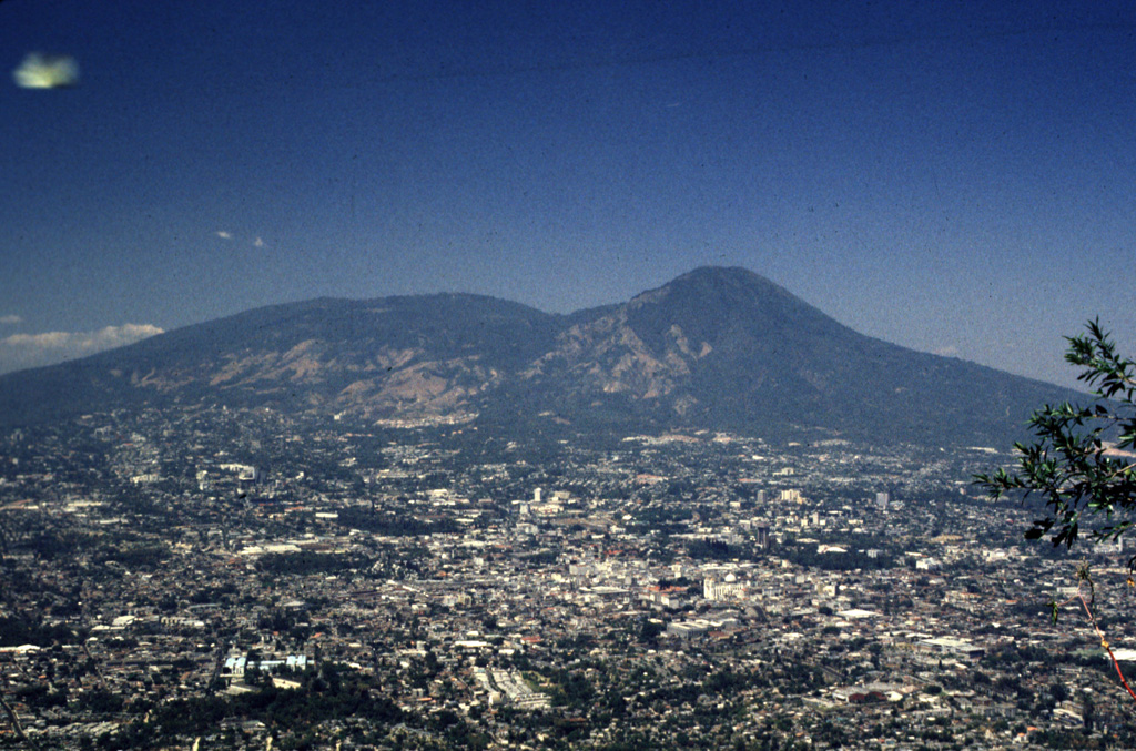
The 1200 eruption may have been a VEI4, a repetition of which would be big enough to cause major problems for San Salvador.
Vesuvius 79AD was VEI5 - ten times as big, but the Soufrière Hills volcano on Montserrat destroyed the capital of the island, the town of Plymouth, with a VEI3 back in 1995, so it is clear that the El Boquerón system could cause significant problems. I use those two examples as Pompeii is about the same distance from the summit of Mt Vesuvius as the centre of San Salvador is from it's name sake (6 miles) and the town of Plymouth was about the same distance (2.5 miles) from the summit of Soufrière Hills as the large suburbs of San Salvador.
background info link
 Global Volcanism Program | San Salvador
VOLCANO.SI.EDUThe massive compound San Salvador volcano dominates the landscape W of El Salvador's capital city of San Salvador. The dominantly andesitic Boquerón stratovolcano has grown within a...
Global Volcanism Program | San Salvador
VOLCANO.SI.EDUThe massive compound San Salvador volcano dominates the landscape W of El Salvador's capital city of San Salvador. The dominantly andesitic Boquerón stratovolcano has grown within a...El Salvador itself appears to have developed greatly from the periods of unrest in the 70/80's, but i doubt it would be able to cope by itself if it faced significant disruption to San Salvador from a minor to moderate eruption, especially if it happened in the summer rainy season?
In the grand scheme of things San Salvador volcano is far from being on the list of very worrying volcanoes. I see the alert level for Taal in the Philippines has been raised recently.
-
9 minutes ago, SNOW_JOKE said:
The area of the Reykjanes Penninsular is known for it's fissure eruptions so it'll be similar in nature to the Bárðarbunga eruption of 2014-1015, with a few larger phreatomagmatic explosions at first as the magma interacts with the water-table. The whole Reykjanes has been in uplift with de-gassing and earthquake for a good while now so it's not too much of a surprise that a dyke intrusion event is taking place.
Its kind of good that it's happening now (due to the season and covid) as Krýsuvík isn't too far away from Keflavik airport and the Blue Lagoon.
From reports it sounds like a graben has possibly formed so i would expect that we will initially see the venting of steam etc that we saw back in 2014. question is, will we then get the fountains and flows that followed?
From the sounds of it, activity on the peninsula can, once it starts, be a long lived on/off affair over a number of centuries. Buckle up!
-
 2
2
-
-
And a press briefing link.
Volcano alert press conference: live updates
WWW.RUV.ISThe civil protection agency gave a press briefing at 16.00. It was broadcast live on most radio and TV channels and the highlights in English are below.-
2
-
-
On 27/02/2021 at 20:56, The PIT said:
Ah well Etna is looking to be quiet tonight.
However there's a good swarm going on in south west Iceland
Reykjanes peninsula - earthquakes during the last 48 hours (Preliminary results) | Reykjanes peninsula | Icelandic Meteorological office
EN.VEDUR.ISIceland Meteorological office - Earthquakes, Reykjanes peninsula, North AtlanticLooks like an eruption may be about to start.
Aviation ash warning has been bumped to orange, pulse tremor is now ongoing and i understand there is evacuation of properties in the vicinity of Keilir.
-
3
-
-
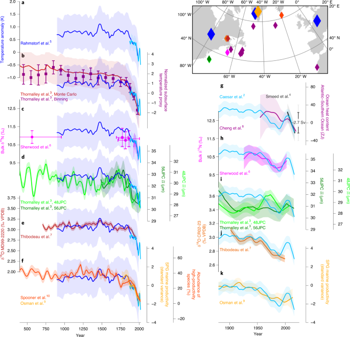
Just seen this in the Guradian - report on a nature geosciences communication paper from today.
Atlantic Ocean circulation at weakest in a millennium, say scientists | Environment | The Guardian
WWW.THEGUARDIAN.COMDecline in system underpinning Gulf Stream could lead to more extreme weather in Europe and higher sea levels on US east coastLink to communication
Current Atlantic Meridional Overturning Circulation weakest in last millennium | Nature Geoscience
WWW.NATURE.COMThe Atlantic Meridional Overturning Circulation (AMOC) is currently distinctly weaker than it has been for the last millennium, according to a synthesis of proxy records derived from a range of techniques.-
2
-
-
Big earthquakes on the Reykjanes peninsula of Iceland where there has been significant inflation over the past year.
Something about to pop?
Reykjanes peninsula - earthquakes during the last 48 hours (Preliminary results) | Reykjanes peninsula | Icelandic Meteorological office
EN.VEDUR.ISIceland Meteorological office - Earthquakes, Reykjanes peninsula, North Atlantic
-
7 hours ago, bearnard18 said:
The comparing Mars and Venus tells that Mars is much more better place for humans to live. Even if that was possible (switching orbit and the removal of H2SO4) , the atmosphere of Venus is around 91× denser than Earth's atmosphere, with other words, the air pressure is around 92 bar. Besides that Venus lacks a planetary magnetic field, has a very thin ozon-layer and worst of all: it rotates the wrong direction!
So from all the planets in our solarsystem, Mars is still the most survivable. Mars lacks a magnetosphere, so solarwinds can cause a problem. But with a normal Moon-spacesuite, humans should be able to survive on Mars.Of all the rocky/solid bodies in the solar system, the surface of Venus is undoubtedly the most hostile to a human landing. Even the robust unmanned probes that have landed there succumb to conditions within hours. The Jovian moon Io is probably second in terms of hostile environment, but that's more to do with the strong radiation field of Jupiter.
The mid/upper layers of Venus however might be tolerable for simple extromophile organisms.
-
1
-
-
38 minutes ago, Zak M said:
Anyone fancy a BBQ next week?
High teens very likely in this set-up. It should feel warm in the sunshine.
All in FI though.
Over winter the ECM has regularly thrown out solutions which depict high uppers getting dragged up to the uk from iberia/East Atlantic. None have ended up being anywhere close to what actually happens with any warmth normally being mixed out before it gets past the Pyrenees. Interesting to see how this latest one goes?
-
6
-
-
7 hours ago, Robbie Coldrain said:
People always says how hard it is to shift a cold block, but in reality it never seems to be a problem. 7-10 days is generally all we can manage before the mild / Atlantic finds a way in. Yes there are exceptions to this, but they are rare.
Think this may depend on context?
When it is invoked to say a breakdown will not happen despite all the models saying breakdown, then yes, you have a fair point.
There is however to my mind, a regular window in the modelling of an Easterly that actually lands, where the models all tend to being over progressive in regards to it's duration. This current one being no exception, when it went from being the mother of all easterlies to the models then saying a Sunday to Wednesday affair only. If someone says the block is being underestimated during this commonly observed model swing they will often be correct.
-
2
-
-
7 minutes ago, chris55 said:
Im confused? They are both the same date and time stamp.....they are the same chart but slightly different?
The second one has // in its legend so i assume it's the parallel run.
-
21 minutes ago, Weather-history said:
This can't be right? Look at those dewpoints for Saturday on GFS 12z
SE feed, so as @nick sussex alluded to, looking at the values over France where the airmass will be coming from, then maybe?
-
1
-
-
6 hours ago, Smartie said:
Strange ice formation on my bird bath this morning.
Excellent, an Ice Spike!
I remember a good few years back a long running discussion in the letters section of new scientist about the mechanics of how these form.
Ice spike - Wikipedia
EN.WIKIPEDIA.ORG-
2
-
 1
1
-
-
4 minutes ago, Summerstorm said:
This is the run he's talking about from the midnight run
Very mild however I would prefer to wait till Mid-March to make the most of the warming sun.
As a contrast to keep everyone happy here is some something of a colder premise with the ingredients for a greenland high I essentially picked a decent one out the bag.
Highly doubt this is what it will look like come the 21st
Ah yes - my bad, i've been looking at the 06z ensembles! Those two charts you have posted with a long fetch southerly would certainly be more spring like.
-
1
-
-
2 hours ago, Alderc said:
Wow look at that little beauty in there, P16 would be record breaking 21/22C. Yes please lets start spring quickly.
If you are looking at around the 22nd and the >10 uppers, then i think it is P14 and 18 - Unfortunately they might both big inversions based on 2m temps so potentially rather grey, cold and rubbish.
-
1
-
-
2 hours ago, StingJet said:
Just an observation on the Fax charts .. a little bizarre , and I cannot recall ever seeing LP @ 1026MB ... thoughts?
1 hour ago, knocker said:It is technically a low if the pressure immediately around it is higher. ...i.e. 1028mb
Hi Knocker - can this be a very shallow/surface feature and not even involve any circulation, or rising of the air mass through the whole troposphere?
-
6 minutes ago, andymusic said:
Noticed anything weird about those charts at all?
Perhaps they have renamed the shipping forecast areas?
-
3
-
-
7 minutes ago, StingJet said:
Just an observation on the Fax charts .. a little bizarre , and I cannot recall ever seeing LP @ 1026MB ... thoughts?
If it is an area where the air mass is moving upwards and thus drawing surface air in underneath then i would guess it's technically a low regardless of central pressure?
-
3
-
-
4 hours ago, Snowboy111 said:
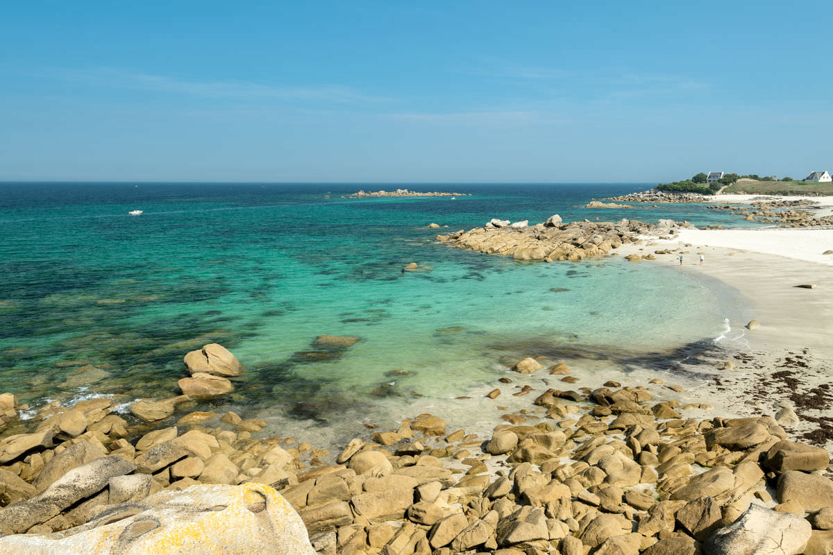
Praying the front over France heads north enough to hit us in Guernsey
Looking at it now, you may just get lucky and catch the northern edge?. If it clips you after sundown temps will have dropped even further.
Web cams in Roscoff are still of snow that is not settling, but a few miles along the coast at Plouescat it is settling very well on the beach right down to the waterline!
Webcam Plouescat : plage de Porsmeur | Office de Tourisme Roscoff
WWW.ROSCOFF-TOURISME.COMUne webcam située sur la palge de Porsmeur à Plouescat-
1
-
-
20 minutes ago, Skullzrulerz said:
I wonder if this could make inroads into Cornwall
It's certainly looks further north than i believed it to be forecast, so you never know. Whereabouts are you in Cornwall?
-
2 hours ago, Snowboy111 said:
Praying the front over France heads north enough to hit us in Guernsey
2 hours ago, AWD said:Surprised we aren't hearing from our Southern Cornish members more.
Quite a rash of snow showers over Redruth/Camborne/Penzance etc.
Looking at web cams around the Lizard, looks like sleet/rain rather than snow, so probably little to report. Higher inland areas may be doing a little better?
Likewise in France, Clearly showing snow on web cams around the coast such as Roscoff, but no evidence of any of it settling and Morlaix (a few K's inland) only has the the lightest of dustings. So while looking good on the radar, that front is not really delivering anything significant at the mo.
Edit.
Just to add, lightest of snizzle on and off in Exeter this morning.
-
15 minutes ago, snowice said:
West England, Wales could be buried as the front stalls.
That's an impressive level of percipitation when the mslp is 1030mb!
Trying to think of other situations where you see rain under that level of pressure? Snizzle maybe in a inversion, can't think of many others.
-
2
-
-
4 minutes ago, philglossop said:
Remember December 2010- weekend before Christmas with possible channel low? Which slid South and whilst we got a dusting and little more?
I'd expect much the same this week...
Yep, think we were under an orange warning at one stage for that.
-
Just droping @carinthian update from the MAD thread in here.
Afternoon, sorry a bit late with an update. The team have provided the results for the outer parameters from the snow forecasting computer. The fine mesh model is unable to provide depth as far out as the British Isles but flags up snow prospects and locations for SE Britain. Snow prospects good across the Southern Half of Northern England , especially Saturday evening into early Sunday. The band of snow then focused further Southeast during Sunday. Monday appears to show convective snow shower activity quite widely across much of Eastern Britain with some extending further west. Tuesday could be the surprise day as their charts indicate some sort of disturbance in the flow from the Low countries with snow prospects being flagged up more widely for a time ( Humber to IOW ). All in all good prospects for some snow for many but surprises can occur almost anywhere. Longer term, a swift removal of the Ac to a more maritime air type likely to be less progressive across the north. However, thats still some days off . Just enjoy the snow and real cold whilst its here, at least for you lot in blighty.
C
Highlighted bit may be of interest for the usual snow starved Dorset/S.Devon coasts and maybe Channel Islands in the event that there are troughs in the Easterly flow.
-
3
-
-
1 minute ago, Thundery wintry showers said:
Yeah, I hadn't really thought of that possibility (the cold air being mixed out and then cold rain), probably because I haven't lived in this area of the UK for that long (January-June 2009 and October 2014 to present) and haven't experienced any instances of that in this period. I'm aware that the region missed out on potential frontal battleground snowfalls around 13 January 2010 and at times in January 2013, when snow accumulated over Dartmoor but not here.
Yeah, i think it's a case of the wind direction just being a few degrees in the wrong direction for a bit too long ahead of any fronts means less cold air over the channel inevitably gets dragged into the mix. By the time the fronts get NE of Bristol - leading edge is much more likely to be all snow


.png.04b552076d7406b2de565f4c22676367.png)


Do you believe in possibility of life in other galaxies?
in Space, Science & nature
Posted
Big question is "complex" life? As the difference between simple single celled and complex life that has cell differentiation is huge.
Alien single celled forms of life must be a certainty, at this level it is just a case of the right conditions and suitable time periods being available for the inevitable biochemistry to occur.
Complex multicellular life however is a very different kettle of fish. It is postulated that simple, single celled forms of life emerged multiple times on the Earth at the earliest opportunity, but multicellular organisms just a few times as this requires a very rare set of events to happen.
My punt however is that given the sheer size of the observable universe, there will be enough opportunity for complex life to have evolved, and sentient intelligent life is a natural progression from that point.