


stokepa31
-
Posts
65 -
Joined
-
Last visited
Content Type
Forums
Blogs
Gallery
Events
Learn About Weather and Meteorology
Community guides
Posts posted by stokepa31
-
-
- Popular Post
The world is looking promising. Woke up to first snow of the winter in normally unsnowy Coventry. Next few days will hopefully see full alignment of the models for a repeat performance on a larger scale

-
 30
30
-
A few flakes in Coventry NE. Im expecting just under 1mm for the day
-
5 minutes ago, I remember Atlantic 252 said:
No, nothing Thurs or Fri, looks like ending with a whimper, latest GFS has us 9° on Sunday
yip, all over bar the shouting, Been a fun few weeks following the charts though. Even though Coventry has had a poor showing of snow i have learned much
-
BBC national forecast now includes friday. they are still going for snow pushing north. im not so convinced
-
6 minutes ago, AppleUK 123 said:
Morning all, Arpege is the 'best' for snowfall in the West Midlands, though once again another eastwards shift would be preferable. I also think the Warnings may well be updated today and hopefully they may extend NE a little more to cover the West Midlands Conurbation...does anyone else think the Met Office will update there warnings today?
I dont see it currently, think today will see convected showers make it in and then melt as sun gains strength. 00z runs shows much less snow making it into west midlands for thursday but hereford and worcester would be my pick for a good dump. None of the forecasts seem to want to call friday yet so that will be the day if more western and northern areas are going to get anything substantial
-
 1
1
-
-
Wash looks to be prepping up again. Perhaps the coldest uppers are starting to increase convected PPN. Doubt they will make it to midlands but someone will get a dump further out
-
1
-
-
2 minutes ago, Herefordweather said:
We had 20cms in December. No chance we’ll beat that!
If i had to pick somewhere to be for the next 48hrs id come to you. I think you will do very well
-
1 minute ago, I remember Atlantic 252 said:
bbc though so poor, updated and no mention of Friday at all
Thats because they dont want to speculate. lots of water to go under the bridge re friday.
-
There is a reason surface temps are recorded at 2m. Its a reflection that absolute ground temperature can be influenced by other factor such as solar radiation
-
1
-
-
Its no surprise snow is melting. Sun is actually pretty strong. surfaces soak up the heat. snow falls, covers and then melts as thermal feedback from the ground releases the latent heat prior to the snow cover
-
1
-
-
2 minutes ago, Snowyowl9 said:
Need to ask an expert on here why it does that.
Well feels warm out there today actually with no wind,watch out when those proper stronger easterlies come in,not had then strong at all yet.
Not enough snow cover to bounce solar radiation so its absorbed rather than reflected
-
1
-
-
7 minutes ago, skyblusam said:
Looking around the other regional's it seems a lot got well not a lot from the so called polar low further north. Which in my eye's shows how hard it is to predict where and when heavy snow will fall. Enjoy the cold and hope for showers blowing inland as I think that's our best bet. The problem with this so called beast is its been way overhyped by the more knowledgeable in the mod thread. And most probably because there based where snow is more likely to fall.
I dont think its been overhyped, th mod thread is for the interpretation and discussion of the models. If anything the SSW over delivered as it smashed the Canadian vortex allowing the block progress westerly at pace. Its not over yet. The end of the week could still be epic so for now its a case of sit tight and see
-
1
-
1
-
-
1 minute ago, wednesburybaz said:
i never even had to scrape the car this morning so no frost in wednesbury at all
Thats more likely to do with the lack of moisture in the air than lack of sub zero temps. Gotta love dry air
-
1
-
-
A little kick to a more direct easterly would do me just now. Although I guess that could affect the streamer as the fetch will be shorter
-
does look to be getting more organised. Air across the channel geting colder and convection differential increasing??
-
6 minutes ago, ChezWeather said:
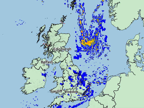
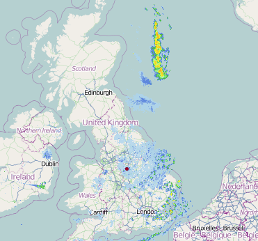
Theres more to this low that what we can currently see on radar (Met Office Precip radar vs NW radar)
i thought the netweather radar was fed from the MET. Ive got them open side by side and they're identical.
-
1
-
-
1 minute ago, weirpig said:
Ecm take on Tuesday
Looks a tad further south than GFS for the low. Id put my money on Staffs doing ok but not much south of there
-
GFS 12z location of the precipitation tomorow at 06:00. Progress south is near non existent through the day as it tracks east. Whatever we get tomorrow will likely be just the odd dusting.
-
4 minutes ago, Brrrrr! said:
Looks like some gentle snow is heading for Coventry/Rugby area, with a slightly heavier band behind it... I hope so anyway
Thats from the Netweather radar
Yes just starting to get a few flakes in CV2
-
Just now, weirpig said:
Strange forecast from shaf on BBC Midlands. Still shows low hitting north and West Midlands stating we are not in the amber at this stage I really don't think they know we're this low is going.
looked like a whispy finger south of the main low to me but i live in hope
-
1
-
-
To be honest today was really about getting the cold in situ. Whilst tomorrow doesnt look great convective snow could increase as uppers drop lower so its not all over. End of the week still has a way to go before its resolved. Think there will be flip flops in position and extent of the warm air flow north
-
1
-
-
4 minutes ago, swipe said:
No snow for the west midlands then apart from a slight dusting?
Tomorrow looked half good in yesterdays runs but it now looks like its shifted further north. May get a spinkle but all eyes to the end of the week for me now for significant possibilities
-
3 minutes ago, Cov87 said:
So hows thursday night into friday looking for the west midlands??
potentially epic but time will tell
-
2
-
-
3 minutes ago, Mike Poole said:
UKMO looks quit a bit further south with the low at T96
Agreed, Greenland high is beefing up a little and closing the gate a bit
-
3
-


Cold hunt - models and chat
in Spring Weather Discussion
Posted
Its no different this time. All you can do is follow the charts and look at the signals and what the models think and apply interpretation. Its weather and it changes but we can look at the output and have an idea where we are going in the hope we arrive at a good place for cold.