


sawan
-
Posts
132 -
Joined
-
Last visited
Content Type
Forums
Blogs
Gallery
Events
Learn About Weather and Meteorology
Community guides
Posts posted by sawan
-
-
9 minutes ago, MattStoke said:
Massive downgrade from the GFS for the end of the week. Wonderful. Hope the ECM has got this one right. Model thread will be over the moon and calling it an upgrade. Bloody southerners.
I agree with the above. MOD mostly consists of London or Greater London based posters. It's not great, may be we need to up our skills to have a strong voice in the thread?
-
1 minute ago, I remember Atlantic 252 said:
ignore that member, was April fool, pulled one of my posts in MOD once, and pinned it to the top of thread, instead of just removing it
Lol, stupid me.
-
3 minutes ago, I remember Atlantic 252 said:
based purely on GFS, model has been downgrading with every run
Someone has posted a snow risk map showing a potential of up to 100cm snow for our region, was it a joke or real?
-
Does anyone use Metcheck? Few days ago it was showing 23cm snow for Coventry, gradually it has downgraded to mere 3cm

-
Just got back from a walk, air is remarkably dry but during my 30 minutes walk the winds have significantly picked up.
-
1 minute ago, MattStoke said:
Covers the SW of the region, I think. My knowledge of the Midlands is rubbish.
Just about misses the Midlands
-
Heavy snow here near Coventry. Settling nicely.
-
 1
1
-
-
Here cometh the toothless 'beast from the east' and bites and and... it tickles
-
1 minute ago, Severe Siberian icy blast said:
No I have had enough I'm looking at closing my account
So sorry to hear that mate. The attitude in the thread is awful. Some of the senior people have already stopped posting.
-
5 minutes ago, Sparkiee storm said:
This is looking quite a big area of snow, bigger than I expected, I know some of its light but there is some heavy stuff in the too.
It was expected to be further south east, this will miss Midlands altogether by the looks of it
-
1
-
-
Incredible! -16C only 72 hrs away, first time ever in my model watching hobby
-
1
-
-
14 minutes ago, andy_leics22 said:
This upcoming Easterly has the potential to be a classic. Still a lot of uncertainty about where the heaviest snow will fall but i'd expect the whole of the Midlands to see something this coming week.
I think we should get 5-6 cm by Friday, Tuesday and Wednesday there might be a dusting, nothing major. Keep the expectations low, if anything above will be a bonus with little disappointment
-
1 minute ago, CK1981 said:
I disagree, their forecasts, especially after day 3 are usually very suspect. They must use a blend of models, but their forecasts often mirror GFS output, and I bet it does today!
OK, let's see. If anything their output mostly resembles ECM. So here is a challenge, you check your precipitation today and then make comparisons with what you actually got in a few days time.
-
18 minutes ago, CK1981 said:
Metcheck use GFS data, so bin that forecast ?
They don't just use GFS, far from it. They use quite a few models. Check their website. Their forecast is mostly right on the money.
-
Heavy persistent snowfall Tuesday morning, from the NE through to midlands into south wales,Some disruption to travel and school closures!. M4 southwards still look dry at this point
-
At t72 hrs Arpege brings some light snow to the north midlands
https://www.meteociel.fr/modeles/arpegee_cartes.php?&ech=72&mode=2
-
Is this a 'non-event' for the midlands,BBC quite a poor app, absolutely useless. Weather warnings of snow with only high cloud symbols for the week ahead. However, other apps are showing some snow during Tuesday. I am sure we'll get some covering, don't know how much, between 3-30cm?
-
22 minutes ago, Polar Maritime said:
This is just amazing. I'm all stocked up here ready, Yes Mark 2013 was as you say very severe with snow wall to wall in the lanes, I was snowed in for days with drifts up to the windows.
Didn't think that the snowline extends to as north as Derby or am I missing something?
-
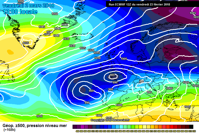
57 minutes ago, knocker said:
The ecm this evening brings the wave seen near south west Norway on the T72 fax south west to Wales by T96 bringing with it some concentrated snow showers along the track. This clears to the south west by T120 veering the winds across southern England and Wales a tad and snow showers running up the Channel
Hi Knocks, what track this precipitation, originating from Norway will follow?
-
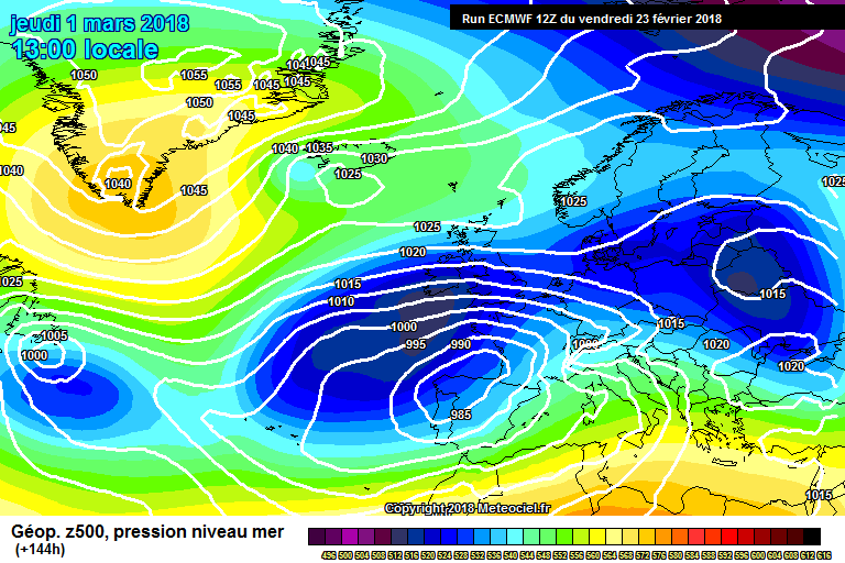
10 minutes ago, Summer Sun said:
Taking the past 3 12z runs from ECM for March 1st you can see how far north the real cold air has shifted it has gone from hitting northern France to pretty much missing them
21st
22nd
Today
The way it's correcting Northwards, it seems that it will shift even more. But we don't want anymore corrections, do we?
-
3 minutes ago, I remember Atlantic 252 said:
EC 12Z, looks amazing, but could be too far south for north of region to join in?
It's still uncertain, most probably EC evolution will win out, too far south. South and East will get dumping of the life time
-
Midlands thread unusually quiet, I wonder everyone in the Southeast thread? :
-
9 minutes ago, cobbett said:
Unbaised ? haha a classic
This is exactly what I meant from my above post, ban the 'one liner' nasty commentators. Before commenting on others please evaluate your contribution to the thread.
I am sorry Knocker, I shouldn't have asked you this in the first instance
-
2
-
-
6 minutes ago, knocker said:
Hi Sawan
I'm surplus to requirements in the MOD thread
but I wouldn't be confident in favoring the evolution of any specific pattern given the fluidity of the upper air at the moment as slight variations can have significant impacts. If pushed I would lean towards the ecm but I have not got sound meteorological reasons for saying that. The way that model is indicating would I suspect be the better outcome for the chionophiles No body is surplus Knocks. It's such a shame that a few so called weather experts are bullies. A few years ago when I joined NW forum, it used be a much better place with no concept of using aggressive/abusive language. I know it's a lot of work but Moderators should filter and ban such people from posting. Please continue the great work there are still many who admire your skills and inputs
-
6
-


The Midlands Regional Weather Discussion 19/01/2018 Onwards
in Regional
Posted
Rubbing salt to the wounds? Lightning in the southeast , winds veering south easterly, show tonight will be for the north and south