


PB22
-
Posts
2,798 -
Joined
Content Type
Forums
Blogs
Gallery
Events
Learn About Weather and Meteorology
Community guides
Posts posted by PB22
-
-
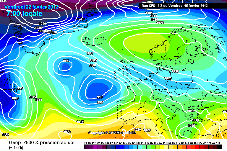
Given how GFS was for so long struggling to grasp the forthcoming pattern, its consistency between the 12z and 6z run is remarkable at T+162:
http://modeles.meteo...fs-0-162.png?12
http://modeles.meteo...fs-1-162.png?12
More of an Atlantic push into the southwest on this run, could bring a significant snow event if it were to verify which is unlikely at this range.
The 12z UKMO is going to be dramatic tonight and not come out!
-
Little change on the 12z GFS so far...I remember not so long ago a chart like this would have the forum in meltdown:

-
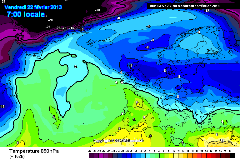
If, and its a big if, the 12Z GFS were to verify, its worth noting that it would become jolly cold under that south-easterly feed despite the higher uppers as it draws in some very cold air at the surface as suggested by the dewpoints:
http://www.wetterzentrale.de/pics/Rtavn16810.html
If you like cold and dry weather then the 12z GFS is your run, if you want to see snow then the 12z UKMO is your run if you're in the southeast.
Once again GFS FI transfers the block towards Greenland which could potentially open the floodgates to an Arctic plunge further down the line. All in all the second half of February is looking cold, cold, cold.
-
12z UKMO T+120 is quite a chart for the southeast especially as the cold drifts west:
Opportunity for the high to ridge towards Greenland by T+150 on the GFS:
-
GFS continues to take a different path to UKMO
Something will give shortly it has to
Yes frosty mornings but milder during the day especially in the sun
The GFS is giving in...we've seen that over the last few runs and today's 12z run has continued that process. Temperatures will start to drop off at the surface from Sunday onwards as the continental feed drifts in. So an accurate summary would be a couple of days of near normal temperatures (not mild by any stretch of the imagination) before these slowly drop off into next week.
-
Well done GFS, you're cottoning onto UKMO and ECM:
T+96:
But what will it do with that shortwave over the Baltic?!
-
When there is the prospect of weather coming our way from the north and east I do like to look at the ensembles for cities out there as well as looking at Greenland and Iceland for clues of where we may be headed. The European ensembles
Helsinki: http://www.wetterzentrale.de/pics/MT8_Helsinki_ens.png
Near normal, but potentially deep cold arriving by the end of the month.
Moscow: http://www.wetterzentrale.de/pics/MT8_Moskau_ens.png
Close to normal, signs of a big drop at the end also.
Berlin: http://www.wetterzentrale.de/pics/MT8_Berlin_ens.png
Turning colder next week, operation run was one of the mildest.
Stockholm: http://www.wetterzentrale.de/pics/MT8_Stockholm_ens.png
Again, near normal but signs of colder conditions in deep FI.
The pressure ensembles can also be telling too:
Good trends for pressure to be high over Scandinavia:
http://www.wetterzentrale.de/pics/MT2_Helsinki_ens.png
http://www.wetterzentrale.de/pics/MT2_Stockholm_ens.png
Whilst pressure over southern Europe is set to be lower:
http://www.wetterzentrale.de/pics/MT2_Madrid_ens.png
http://www.wetterzentrale.de/pics/MT2_Rom_ens.png
The ensembles for Greenland are rather haywire:
http://www.wetterzentrale.de/pics/MT8_Nuuk_ens.png
http://www.wetterzentrale.de/pics/MT2_Nuuk_ens.png
Whilst for Iceland it looks milder than normal:
http://www.wetterzentrale.de/pics/MT8_Reykjavik_ens.png
With hints of rising pressure in a couple of weeks time:
http://www.wetterzentrale.de/pics/MT8_Reykjavik_ens.png
Based on all that what can we conclude? Good agreement for a Scandinavian High next week, with this possibly retrogressing towards the Iceland area the week after. This combined with lower pressure over southern Europe points towards a airflow from an easterly quarter for Britain and Ireland. How cold and various other details to be determined.
-
Signs of a change/flip from the GFS if we look at the ensembles this morning:
http://www.wetterzen..._London_ens.png
http://www.wetterzen...chester_ens.png
http://www.wetterzen...berdeen_ens.png
Many more colder runs in there with the operational and control run on the milder side. The GFS mean for T+144 and T+168 are also rather different to yesterdays:
http://modeles.meteo...-21-1-144.png?0
http://modeles.meteo...-21-1-168.png?0
Far more of a continental influence there.
UKMO 00Z remains consistent with yesterday's output...ECM 00Z now on the way out.
The ECM 00Z remains consistent as well, so it still looks like GFS is catching up:
ECM T+120:
ECM T+144:
ECM T+168:
-
Yes, like a screaming and kicking toddler GFS is slowly coming around to the European models it would seem. Give it a few more runs and it may get there! When was the GFS last upgraded does anyone know please?
-
Hi the charts look great and may I just say Steve M is a legend ... But what are the chances of the ECM charts downgrading andvthe GFS charts upgrading as they have done in the past to meet somewhere in the middle ? And it be a non event again ... ECM loves the easterlys and who can blame it I love a stiff easterly but it does tend to big itself up a tad to then over a few days come online with the GFS .
Please be nice this is very scary x
There's every chance of that happening TootyFruity, more often than not when the two models are showing difference scenarios a middle ground is often found.
The 18Z GFS is now on the way out and up to T+108 there's no huge change:
-
Excellent UKMO and as far as easterly’s go I have more faith in it than the GFS or the ECM, the GFS is certainly floundering but it’s not as I stated earlier just a simple case of the GFS is wrong so therefore the ECM or UKMO is correct, it’s still a long way to go to get a decent cold and snow shot to the UK and a lot of time for model outputs evolve to off in a different direction.
I remember a couple of years back that having the UKMO model on board for an easterly was a necessity...numerous times I can remember the GFS going for easterlies in the 5-7 day range but the UKMO didn't and on most, if not every, occasions the UKMO was nearer the mark. I'm not sure how the models have progressed since then, but I'd still feel happier seeing the UKMO showing an easterly rather than the GFS. Nonetheless it will be fascinating to see how this period pans out.
-
Looking through the GFS 12z ensembles at T+144, only a couple lean towards the UKMO 12z thinking, the pick probably being perturbation 18:
http://modeles.meteo...18-1-144.png?12
The rest are mainly under a anti-cyclonic south/south-westerly flow.
For what its worth, the GEM 12z at T+144 is more like GFS operational:
-
It was lovely earlier when the snow was falling and settling but knowing that it was going to turn back to rain and thaw within a few hours means its just not the same as a good snowfall with cold conditions prevailing thereafter.
-
Ahh bless, the GFS is still trying by T+204:
Signs that the 12z GFS has inched towards the UKMO this evening in the earlier time frame, but there's still a lot to be resolved. You'd think the 12z ECM would lean towards the UKMO output given it's output over recent days.
-
UKMO 12Z T+144 is pretty spectacular if it is cold weather you are after:
-
The UKMO 12z is being very consistent following this morning's run, the T+120 chart demonstrates this nicely:
As for GFS:
-
Can see the rain really pepping up over Ireland now as the next system moves in, a wet evening and first half of the night to come.
-
And that's it...the rain is now coming down. Was a good snow event once more for a breakdown, some 8 hours of good snowfall.
-
Flakes have turned bigger here now...the beginning of the end.
-
Still snowing hard here, have around 6cm on the ground now, more in corners where the wind has blown it about.
-
You used to be on the model thread did'dnt you, respected your opinion, beginning to think this is not going to be heavy now and my worries about getting a weeks frozen food in and having a power cut look unfounded - thinking of going Oldham. What do you make of the ECM and Ens, still no support from GEFS.
Heavy here but unfortunately not insanely so!
Hi, yeah used to be a regular up until a couple of years ago or so. The ECM seems fairly convinced we're heading into another rather cold spell of weather, although I don't see anything particularly notable on the horizon at this stage. GFS isn't interested at all and from experience we do need to see all models showing a similar outcome to have any confidence. The 12z runs later could be quite decisive I feel as to where we're headed.
-
A snowy day here so far, got accumulation of a couple of cm, perhaps more but difficult to tell with the wind blowing the snow about.
-
A slider refers to a low pressure system that disrupts as it comes up against a high pressure block. This basically means that the low splits and sends some of its energy under the block, thus the term slider being used. These sliders can bring large snowfalls in places as the cold air remains in place. The low pressure forecast for the next couple of days is expected to do just that, so check the latest charts for an example, but with the sliding taking place to the east of the country less cold air will make it to much of the UK. If the trough disruption was happening further west then eastern Britain would remain cold with a significant snow risk.
-
The sky looks very very strange as i look out to the north west which is preston way, its very dark, almost thunderstorm look and the sky looks full of something!
Overhead we have broken dark clouds moving in, the clouds are moving north west, so that bit over towards oreston isnt heading this way.
In Preston at the moment and its cloudy, cold and dry. Sky does look a bit threatening though!


Winter Model Discussion 12Z 15/02/13 onwards.
in Spring Weather Discussion
Posted · Edited by Paul B
UKMO 12z now coming out:
T+96: http://www.meteociel...96-21.GIF?15-17
T+120: http://www.meteociel...20-21.GIF?15-17
Similar theme to this morning's run, the Scandinavian High a touch further south than the GFS has it.