


SnowBlake
-
Posts
95 -
Joined
-
Last visited
Content Type
Forums
Blogs
Gallery
Events
Learn About Weather and Meteorology
Community guides
Posts posted by SnowBlake
-
-
22 minutes ago, sunnijim said:
Looking promising for later Sussex coasters! As I said yesterday, it looked as though the parimiters were in place for better convection today than we have seen so far in this cold spell.
Those that have done well with snow so far have seen their totals mount through the persistence of the snow in favoured spots rather than anything heavy.
Sky looks primed here with convectice clouds developing.
If we are lucky here,and it is quite a big if, we should see snow at a colder time of day ( after 3pm) for it to stick.
Anyway,snow or no snow here I hope those that have missed out so far are aloud to share,rather than those that have already had a dumping!
I think there will be heavier bursts for a couple of hours max but may just give a cm or 2 covering, won't be half as heavy as those over Kent.
-
 1
1
-
-
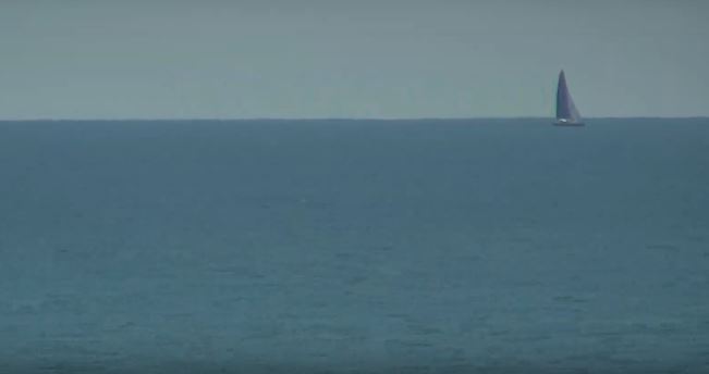
Seems to be settling on Hastings Beach. Can see flakes falling from lampposts. More precip building heading that way.
 Hastings coastal webcam - Beaming
WWW.BEAMING.CO.UKThe Hastings coastal webcam takes in Hastings Pier, Hastings Old Town , Hastings Beach and the English Channel. Brought to you by Beaming, the business ISP.
Hastings coastal webcam - Beaming
WWW.BEAMING.CO.UKThe Hastings coastal webcam takes in Hastings Pier, Hastings Old Town , Hastings Beach and the English Channel. Brought to you by Beaming, the business ISP.-
1
-
-
Keep an eye on this circled area. Edging closer, could come into play. Those who can see movement of this on a radar, take a look and you will see it has potential to bring those in the SE something or at least help get further precip. Could be a nice little surprise.
-
 1
1
-
-
Interesting feature just south of Brussels/Lille edging towards the far south east.
Seems this could potentially spawn some extra precip around 3-6am.
Could...
-
1
-
1
-
-
Midnight here in Latvia, i am on night duty running taps every hour and the pump from the well every 30 mins, breaking up ice in water troughs for the sheep, and only errr... minus 19c outside. Could get to minus 27c over then next few days. Seems only to snow here between 1c and minus 10c. Had snow on and off and coverage since before Christmas Day.
Had Beaming site's Hastings Webcam on for large parts of the day. Seems go have had some moderate snow earlier. During the day it pans around the coast and at night remains static but can see flakes blowing around at times.
Anyone got settling snow in Hastings? Seen reports in Bexhill.
Thought I might miss a rare event but seems I haven't missed much.
Yan can still go back to around 9.30/10.30 this morning for the heaviest.
Hastings coastal webcam - Beaming
WWW.BEAMING.CO.UKThe Hastings coastal webcam takes in Hastings Pier, Hastings Old Town , Hastings Beach and the English Channel. Brought to you by Beaming, the business ISP.-
3
-
-
4 minutes ago, Flash bang flash bang etc said:
Literally not even joking - the power just went off to the lamppost
Energy saving probably 1am timer?
-
2
-
-
8 minutes ago, Angus Mcoatup said:
My local BBC app shows light snow from now until 6pm on Monday.
I’ll believe it when I see it
You've seen it, apparently!
-
4
-
-
Nothing will die out, coldest still crossing north sea, will generate further precip as it does so whilst dragging in colder air from the continent.
-
5
-
-
I just popped this in the MOD thread, may be useful for some here.
-------
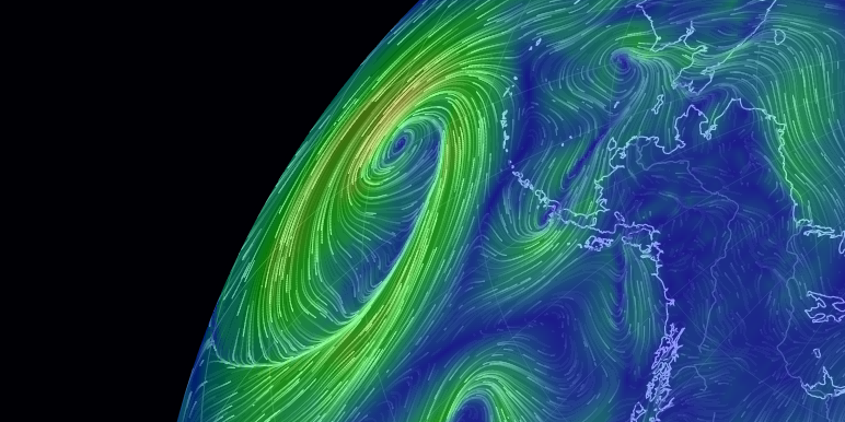
Don't forget the live wind direction/speed map here!
earth :: a global map of wind, weather, and ocean conditions
EARTH.NULLSCHOOL.NETSee current wind, weather, ocean, and pollution conditions, as forecast by supercomputers, on an interactive animated map. Updated every three hours.Even over the far SE it is now NErly wind. Just waiting for the cold to start closing in which is probably over Belgium.
Good luck all, from a snow covered Latvia ❄

-
4
-
1
-
-
- Popular Post
Don't forget the live wind direction/speed map here!
earth :: a global map of wind, weather, and ocean conditions
EARTH.NULLSCHOOL.NETSee current wind, weather, ocean, and pollution conditions, as forecast by supercomputers, on an interactive animated map. Updated every three hours.Even over the far SE it is now NErly wind. Just waiting for the cold to start closing in which is probably over Belgium.
Good luck all, from a snow covered Latvia ❄
-
10
-
1
-
48 minutes ago, That ECM said:
You’ve read the chart wrong. You will get ten times that.
You've also read it wrong, it'll be 100 times that!
If amount is accurate.
-
2
-
1
-
-
10 minutes ago, snowking said:
I'm afraid aside from the GFS, the trend to push everything further SE is continuing, with the Arome and Harmonie models also significantly further SE than on their 6z runs.
At this rate, we might as well just get rid of the system and rely on showers off the North Sea instead
Could bode well for Hastings, although I am in Latvia with plenty of snow. Seems 30-40% of models showing now that Kent streamers likely, hopefully extending to Hastings. I shall watch the live webcam on Beaming (and other sites) as it pans around the seafront to. Typical I miss that snowfall when I am not there... possibly.
-
2
-
-
11 minutes ago, Tim Bland said:
By Dan Holley ...
Also Dan Holley in 2014 posted a graphic elsewhere showing Thames and Kent streamers. Something highly possible over the coming days.
http://www.weatherquest.co.uk/news-archive.php?idx=64
Although I am not sure how NE the winds may be. The more NE the better for Kent and East Sussex, the more ENE the better for N Kent, Surrey towards Hants perhaps.
Winds curling round into the centre of the Low could mean more NE for the far SE corner.
48 hours out, still no certainty!
-
2
-
-
17 minutes ago, Nick F said:
Oooh, look at all the white heading our way on Met O precip animation
I think I am happy to not be in the UK currently. Hastings and the E Sussex coast seem to remain in the blue, half the models showing 1cm to 8cm, half showing nothing. Although I think the icon and euro, show best along with GEM showing kent clipper streamer for best part of the day Monday.
Although it will be a shame to miss out on snow I have yet to see in 5 years residing in Hastings, i have had lying snow (1 inch to 8 inches - some drifts recently with some powder snow and winds) since before christmas and temperatures down to minus 23 a couple of weeks ago here in eastern Latvia. Minus 10 daytime today!
Off skiing near Daugavpils tomorrow, on one of the few hills Latvia has, but at a proper skii centre.
-
1
-
-
1 minute ago, Chertseystreamer79 said:
That's 4mm rain which equates to coupios amounts of snow. Not quite sure what the actual ratio is.
Approx 1mm is 1cm of snow. So 1:10. Apparently but I think it depends on the type and size of snow too. Wetter larger flakes may be heavier so compacts more, lighter or drier snow may appear to give more as it is less dense.
-
Seems Hastings area will most likely miss out again due to being on the coast, which is fine, as I am still in Latvia since before Christmas, thankfully both partner and I can work remotely, not that I have much work, and her family location here in the East of the country has had lying snow (albeit one day it melted down to ice where you could see the ground start to appear before a top up) since 19th December.
No proper snowfall since before new years day (we went downhill skiing on 2nd Jan - no many locations to do this here as quite a flat country, was a 90 min drive to the slopes) but light continuous snow and flurries which don't show on the radars could give a 2 or 3cm top up over night.
Each day you need to try and get the snow off roofs, and there are 6 buildings on the land here, plus shake snow off branches and trees where possible, to avoid snapping branches or the foliage dying and going brown on the conifers around the property.
Also every hour ensuring water for the animals hasn't frozen over, clearing snow off the electric wire around land the animals are currently on.
In Dec 2017 or 2018 it snowed on 12th December and they didn't see the ground until mid February, so another 3 weeks is possible to match that.
2 weeks ago it was minus 14 high and overnight minus 22 low for 6 days. Spent time with her grandmother 500 metres from the Russian border during that time as pipes from the well would freeze quickly and that level of cold with her joints etc is difficult to get about and to constantly keep her wooden handbuilt house warm.
Ordered more firewood to chop up to replace the more than usual amount used although there is a good 3 years of wood stockpiled.
A lot of Latvians ensure they have 2 or 3 year supply just in case. Heating my partners family home takes about 6 pieces of wood about the size of a loaf of bread to heat it up for about 18 hours when around 0c outside.
Has been hovering just around or below 0c to minus 5 recently but back down to minus 12 today... maybe reaching minus 20 overnight over the weekend. Hopefully you all get some snow wherever you are!
Here are some snaps from Christmas/New year period when the snow was better than it is now.
Good luck all for the coming days.
-
4
-
-
49 minutes ago, Man With Beard said:
I think I've found why we're having so much trouble getting snow modelled on an easterly - check out the SST anomalies over the Baltics - 3 or 4C above normal, and no ice cover.
Current Operational SST Anomaly Charts - OSPO
WWW.OSPO.NOAA.GOVThe Office of Satellite and Product Operations (OSPO) is part of the National Environmental Satellite Data and Information Service (NESDIS). NESDIS is part of the National Oceanic and...Trace most of the windflows for next week and they come straight over not only the North Sea but the Baltics also.
ARPEGE gives snow throughout Germany/Poland early next week except on north coasts, so no probs with dew points if winds come from there.
Study ensembles with less Baltic influence and I bet they'll have better dew points.
I'm still in Eastern Latvia until Sunday, had snow cover since 23rd, cross country skiing 4 times, melted a bit then froze over a bit, topped up, snizzle and drizzle, froze over, still soft and snowy underneath, can still ski in parts, more snow due tomorrow evening until Sat afternoon, potentially 12 hours of snow, plus it snowed with little on the radar yet GEM still showed light snow.
As mentioned before, GEM has been spot on 3 or 4 days out with precip type here, even on 19th it showed snow for Christmas.
GFS showing marginal snow/rain even tomorrow here. But it would be good to come back to the UK and have a period of snow watching, albeit right on the seafront in East Sussex where I think once in 5 years there have i only seen a dusting.
-
6
-
-
- Popular Post
Merry Christmas one and all from a snowy Latvia. Here in the east we had a further 3 or 4 inches overnight.
Made it here 3 days before the UK and Baltic states placed travel bans, will worry about the return trip on 3rd when it comes to it!
I must say that the GEM has been the most consistent and accurate in terms of precipitation charts. GFS and others were hit and miss showing more rain than snow but all that has fallen is snow. GEM was first to change 5 days ago to increased chance of snow here yesterday and today and has added light snow to fall for the next couple of days with barely a break. Been spot on 3 or 4 days out.
I have seen from some posts above that Hastings looks to possibly receive a little wintry precip after the weekend, typical that when I go away, this may happen. However, i mustn't grumble. I have this outside right now - taken in the past hour. 3 or 4 inches overnight on top of yesterday's inch or 2.
As much as most in here are wishing for snow, of course there are more important issues currently and I hope that you all stay safe, look after yourselves and those you're able to share today with.
Now go get a drink inside you.
My Latvian partner's family are about to sample a snowball. Let's see how well this goes down.
-
18
-
1
-
Just now, Zak M said:
The pub run is sober tonight?!
I think I’ve seen it all...
Had to have a meal with it's food so stomach lined and alcohol absorbed.
-
39 minutes ago, alexisj9 said:
That looks appsolutely phantastic, bank.
Snow would stream in off the North sea, no problem there.
I think more so for those Norfolk and north, not sure if there is enough distance over sea to generate enough precip for those a bit further south.
Off to Latvia but flying in and out via Tallinn as we planned to do 3 days there before heading to partner's family in Latvia, so as long as I can enter Tallinn and go direct to Latvia (central eastern), from 17th afternoon til 3rd Jan will hopefully get my fill of snow. Last year we had a few showers but 10 miles north and south got hit by several inches.
-
Keeping an eye on the features over Le Havre and NW of Paris heading towards the south coast. Earlier we had a short period of rain, tiny bit of hail mixed in, couple of rumbles but little else in Hastings. Fingers crossed for something a bit more exciting later!
-
1
-
-
3 minutes ago, Electricmumma said:
Okay clever peoples, I’m in bexhill, can reach anywhere that a train can reach to, and where there’s a hotel/b&b, looking to be really ‘in’ a storm, fed up of these brushing along in the channel but not actually doing anything here for the atmosphere. any ideas on the nearest almost likely location?
i would say Guildford/Woking/Basingstoke. Can get to so many places - Portsmouth, Bournemouth, Southampton, Farnborough, London, Gatwick, Farnborough, Reading etc directly. Gatwick area again, so many direct places to get to, including Luton/Bedford, and also Reading.
-
4 minutes ago, Sam Jackson said:
this has puzzeled me have some cold breeze followed by hot brezze every other second
Something worth seeing your doctor about perhaps...
-
1
-
-
1 hour ago, SenlacJack said:
What's died down in Hastings ? I'm 2 miles inland and apart from some ocassional lightning flashes this has been a non event as far as I can see.
Was sat on the beach for 90 mins watching some semi impressive lightning about 10-15 miles off the coast. Posted gifs earlier


.png.8f95a069b90a475a2025868973682abc.png)


South East, London and East Anglia regional discussion - 8th February onwards
in Regional
Posted
If it falls at a heavy rate from the start the ground will cool plus when the sun goes down around 4.30/5 would have more chance.