


comet
-
Posts
264 -
Joined
-
Last visited
Content Type
Forums
Blogs
Gallery
Events
Learn About Weather and Meteorology
Community guides
Posts posted by comet
-
-
Very encouraged to see the trend in the models for the mid and extended range with northern blocking and perhaps even heights building up into Greenland. I said some while ago that this is a good sign to see in the Autumn and would be likely imho to repeat in the winter months ahead should it verify of course.
-
From what I can see there is nothing at all unusual about the QBO and its propagation down through the strat. Posters are trying to find problems when there aren't any and of course it is getting colder at 10mb it would be far more unusual if it wasn't.
-
 1
1
-
-
GloSea etc made a mess of it last year and judging by the ridiculous bias for warmth across the northern hemisphere this upcoming winter unless these updates change then I can see them making a pigs ear of it again. I doubt we will here anymore talk of the met being able to predict winters in the UK a year in advance after last years failure and the extremely unlikely output from their models for this coming winter for the northern hemisphere as a whole.
-
The QBO may well be our friend this winter making the stratosphere more susceptible to northern blocking. Perhaps one of the main catalysts for strat warmings I think is a strong MJO like we saw in 2009 with a negative QBO. The difference this coming winter though is the likelihood of a weak Nina which dampens the wet phase of the MJO unfortunately and strengthens the likelihood of the dryer phases. Hopefully the Enso turns out to be more cold neutral or neutral this coming winter allowing for a couple of strong MJO events coupled with the negative QBO to give a greater propensity for cold outbreaks down into the mid latitudes and our neck of the woods.
-
5
-
-
I am hoping that we do not see a propensity for blocking to the east, northeast during September like we have the last few years.as I feel this is detrimental to the upcoming winter for our neck of the woods. Of course many will say that this has no bearing on what may lay ahead during the winter months but after looking through past h500 archive charts imho the Autumn synoptic weather patterns do have an impact through the December - February period both up in the stratosphere and lower down into the troposphere. It also appears to me that mid Atlantic ridging up into Greenland during September into October is very important rather than just a - AO signature and is likely to be repeated during the winter months giving a greater likelihood of a - NAO winter.
-
1
-
-
Whether it be negative or positive qbo no one really knows what actual forcing it has on the other teleconnects. I have my own theory that when the qbo is in either phase in a very strong mode it does not bode well for the prospects of cold for the UK in winter. it is basically a lottery that no one knows the answers to. The same can be said for strat warmings as we have seen the last couple of years, yes we may be able to predict when a warming is more likey than not given the qbo state etc but we are definitely no nearer forecasting what likey impacts the warming would have and where.
Last year the met came a cropper announcing that they cold now reliably predict UK winters a year in advance due mainly to GLOsea 5 etc only to fail at the first hurdle
-
-
1
-
-
5 hours ago, northwestsnow said:
This mornings Ecm is positively pathetic for June, i booked the first 2 weeks of june off some months ago hoping for the best, i should have known better, looks dreadful for much of Europe away from the more southern parts thanks to northern blocking and southerly tracking lows...great.
Certainly looks like a mixed bag as we go into June. Nothing wrong with those that try to look ahead with the different indicies ie glaam , mjo ,qbo etc etc etc remembering of course that these predictions, thoughts, or musings call them what you want often go the way of the pear.
-
1
-
-
55 minutes ago, mb018538 said:
Perhaps people have forgotten it's still may! It was 24c here yesterday, 22 today, next few days are forecast 23/25/26/28/27/24....it'll be well over a week of well above average temps. This is like getting snow in mid november, a big bonus!
Getting snow in January is a bonus these days. Hopefully down here in the south east we can scrape through Bank holiday Monday before the inevitable breakdown.
-
3
-
-
4 hours ago, knocker said:
Actually the timing of this may well be be quite fortuitous as the ext EPS and EC46 are indicating a fairly quick breakdown after the weekend with the first week of June being trough dominated and quite cool.

That would be the form horse imho not wanting to get suckered in by the models just yet.
-
1
-
-
The cold spell that I posted about occurring post Easter rather than the Easter period itself really seems to be gaining momentum now. Large temperature drops in heavy convective wintry showers likely almost anywhere I would imagine and if the 06z gfs is on the money (that's a big if) then perhaps a more prolonged period of sleet and wet snow working its way down the country.
-
1
-
-
40 minutes ago, Frosty. said:
I actually don't think the Easter weekend will be bad at all, at worst it's likely to be sunshine and April showers, some heavy with hail and thunder but they would die out if high pressure nudges in as shown on the ukmo / gem 12z and any cooler / colder air would be negated by the increasing strength of the sun which is already as strong as early september.
I think it is almost a given that any pronounced colder weather will be post Easter weekend. Quite a few of the gefs showing -8c 850 temps pushing down across much of the country post Easter.
-
1
-
-
2 hours ago, Surrey said:
Hardly looks bad next week away from the far north. High pressure never far away and the cold air never really makes it to the south. So while it will be cooler, I don't think it will be anything near as bad as it was showing.
Best get use to it as summer is just round the corner the very deep depths of the gfs even show our first attempted plume!! That will change of course
I would say the opposite. The colder weather that looked set for the Easter weekend now looks to have been put back but the Gefs suite looks almost unanimous in agreement on northern blocking and Greenland heights after the Easter period with the depth and southern extent of cold push still undecided.
-
2
-
-
A very cold looking set of gefs once this lovely weather breaks down.
-
5
-
-
I must admit I would not be surprised to see weekend temps especially on Sunday hitting the low seventies in many southern locations. As for the 06z gfs run well its showing the sort of synoptics we were graving for back in Dec, Jan and February with plenty of precipitation to boot.
-
1
-
-
51 minutes ago, Frosty. said:
Winter returns during Easter with snow for many and frosty nights on the Gfs 00z.
It looks like the much colder spell for around the middle of the month is starting to gain a lot more traction now although nothing set in stone of course. Loving the warmth and the weekend to come that's for sure.
-
1
-
-
I for one feel confident we will see a potent Arctic incursion sometime around mid month lasting for several days perhaps.
-
1
-
-
Here in Lehighton county we received approx. 9 inches. Due to the more northerly track of the storm this was way below the expected 18 to 24 inches forecasted.
-
Can not believe my luck. After such a poor winter in UK, I am on a business trip here in eastern PA just in time for their biggest winter storm of the season. Could very well be the biggest snowfall I have ever witnessed with amounts predicted for the area to be in the region of 18 to 24 inches. The deepest laying snow I have seen in Hertfordshire is approx. 12 inches with drifts to around 3 to 4 feet.
-
1
-
-
A cold snap (spell) is definitely gaining momentum now but as to how cold and how wintry is still very much up for grabs. This should become a lot clearer I would of thought by the start of the new working week.
-
1
-
-
1 hour ago, snowray said:
As for the rest of us, well the juicy charts from the other day have all but gone, as usual, so no surprises there.
Maybe a glimmer of hope there from the ECM.
I would not be at all surprised to see substantial height rises to our north in the 8 to 10 day period which may well usher in a much colder outlook beyond this.
-
3
-
-
23 hours ago, Bring Back1962-63 said:
As expected really and not just be myself height rises being modelled to the north of the UK in roughly 8 days time very similar time line to what we saw with the stratosphere warming and trop response earlier in the month. This is what led to the Scandi ridge and there is no reason why this should not happen again perhaps with a more potent cold spell this time.
This is almost certainly a trop response to the ongoing strat warming
-
1
-
-
Right at the end of fi but worth a mention. If the synoptics turn out to be anywhere near accurate then it would certainly be interesting and quite possibly noteworthy. The time frame would also fit with tropospheric heights building several days after the SSW similar to the warming at the beginning of the month.
-
2
-
-
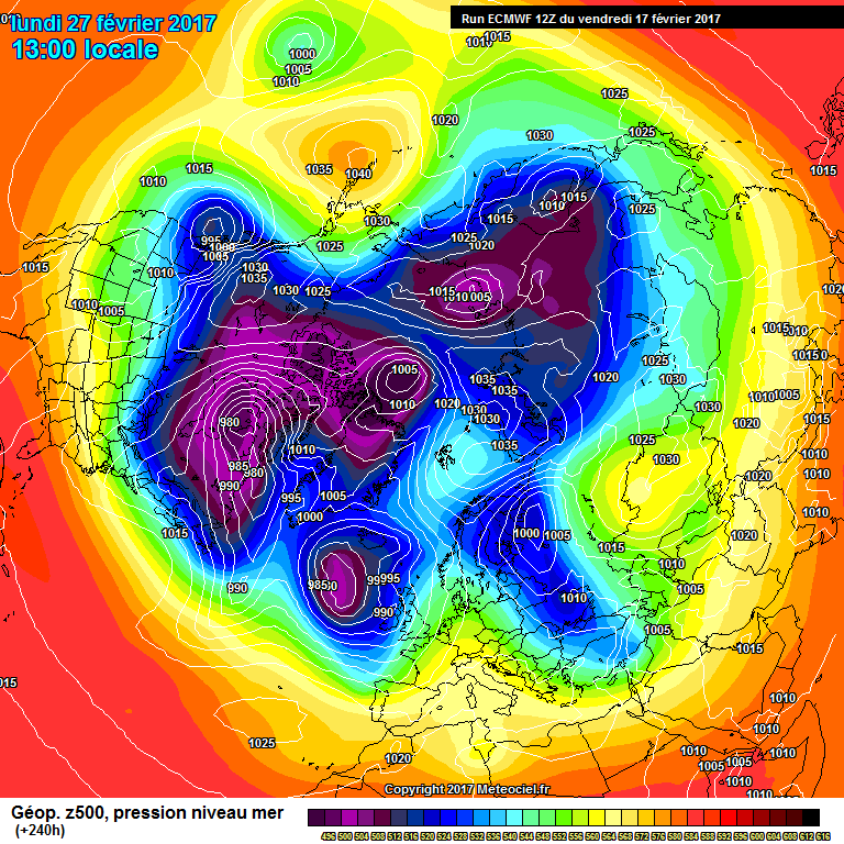
1 hour ago, Man With Beard said:
In addition to an impressive GEFS suite (more than 50% northerlies by T288), another straw to clutch from the ECM perhaps? Potential for the Atlantic and Scandi lows to combine leading to a sharp NEly?
ECM t240 charts not really worth commenting on but when tied in with the GEFS there is a definite trend for heights to build somewhere to our north. Although timing of this also seems to be an issue and the best one could say is end of Feb onwards probably. Still in the game maybe if and its a big if they can bring cold enough uppers down with them.


The Seasonal Forecast Thread
in Spring Weather Discussion
Posted
Nice trend developing in the mid to long range on the model output. Would be confident in seeing this repeated during the winter months. Good sign Imho.