


N/A
-
Posts
76 -
Joined
-
Last visited
Content Type
Forums
Blogs
Gallery
Events
Learn About Weather and Meteorology
Community guides
Posts posted by N/A
-
-
10 minutes ago, Jonathan Rhodri Roberts said:
Some very low windchill charts next week on the GFS but just how reliable are they? I'm currently in Merthyr Mawr on the S Wales coast (shown in the red circle) for example and it shows 2C however the sun is out with very light winds and I've had to take my fleece off as it feels very mild. So personally I wouldn't rely too much on them. Therefore next week while the thermometer is low the "feel like" temperature could be considerably milder if the sun is out and the winds are light with the sun now rapidly gaining strength again at this time of year as well as the daylight hours becoming longer.

Tbf you can never calculate a windchill temperature from a chart. The only accurate way is measure the actual 'in the shade temperature' against the wind speed where you're at and then work it out using the formula. After all some streets, bays, beaches etc... can often feel mild or even warm while others exposed to wind can feel cold or very cold even if it's just yards away!
-
 3
3
-
 1
1
-
-
20 minutes ago, Nicholas B said:
I would say that going off the first chart, those of us in Kent away from the coast would be best placed for a decent fall of nice 'dry' snow.
Could be but also the Pembrokeshire Dangler is notorious for feeding in a real mixed bag of rain, sleet, snow or hail showers with even thunder & lightning from off the Irish Sea. This scenario can last for many hours or even days in a slow moving weather pattern which brings some impressive precipitation totals
-
1
-
-
9 minutes ago, Draig Goch said:
Western coasts of the U.K. & Ireland look like getting the most precipitation next week but that will probably be a combination of rain, sleet, snow & hail. Tuesday night into Wednesday could be the best chance of seeing snow in the west, however it's possible to see a further mix of frequent heavy rain, sleet, snow or hail showers with a risk of thunder on Wednesday evening into Thursday across W Wales, N Devon & Cornwall as a "Pembrokeshire Dangler" develops so plenty of potential in what's been a snow starved west for the last several winters
And it looks like it's that Pembrokeshire Dangler which will bring the heaviest precipitation when comparing the total accumulated precip chart with the convective precip chart
-
1
-
-
Some decent cold, snowy weather around next week but it's a shame the GFS brings milder air back in next weekend, brief I know but it does shunt the coldest air eastwards away from the UK which puts us back in the polar maritime air which is often very disappointing for my area snow-wise. Anyway we still have much of next week to enjoy across the UK & Ireland, if you like the cold that is
-
1
-
-
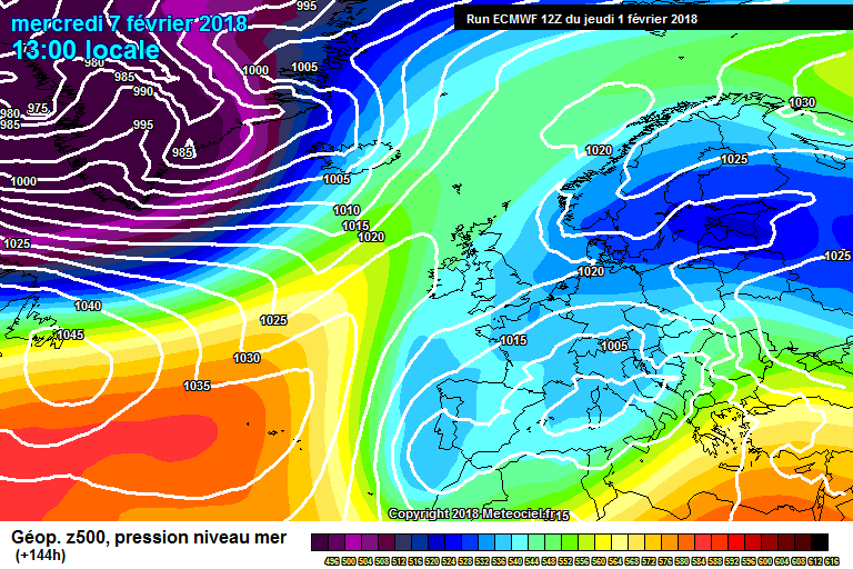
10 minutes ago, Captain Shortwave said:
The ECM stalls that front up the western side of the UK which is pretty consistent with previous runs. As for the east, SUnday looks good with possibly a disturbance moving close to the south east but the wind veers more south easterly for Monday/Tuesday which would probably mean dry and sunny with little sea track to develop showers. That said, best of the bunch for trying to re-engage an easterly flow.
With sea temperatures almost at their coldest that could be great news for here in Pembrokeshire as well as other western coastal areas who so far have seen diddly squat
-
1
-
-
44 minutes ago, Daniel* said:
UKMO is stunning bitterly cold across the SE in particular and EA the T+72 FAX chart with the all important human input is mouth watering. Dare I say maybe Thames streamer territory.
That front over Ireland looks interesting for us in west Wales nevertheless that's still a cold chart even if it will be dry. Could well be heading for the coldest weather we've seen for several years!
-
2
-
-
8 minutes ago, Ed Stone said:
The last time I checked the BBC website, Monday's max and min were +6 and 0C respectively...Ergo, there must still be some inter-model uncertainty - Sunday's GFS12Z:
Yes it seems like the uncertainty continues on the models because here in southwest Wales its still showing 8C & 4C for Monday
-
Exceptional charts again today, GFS 6z show 850mb temps of -8 / -9C for Wales next Tuesday afternoon but at the same time the BBC forecast for here in Tenby is showing 8C with unbroken sunshine. Now either the models are disagreeing with each other or that's one hell of a very steep lapse rate which may end up triggering off some heavy, thundery showers!
-
2 minutes ago, Draig Goch said:
I'm confused now, UKMO and many other charts show widespread cold developing but yet Swansea BBC forecast is dry from tomorrow until well into next week with daytime highs between 7-9C throughout. Very strange
I agree as it's similar for Tenby Pembrokeshire between 6-9C and apart from light showers Saturday it's dry with sunny spells. Now that could be the result of an easterly as it often brings drier, sunnier weather to the west but as temperatures are measured in the shade not in direct sunlight, I'd have thought it would still be colder than suggested tbh
-
2
-
-
3 minutes ago, bluearmy said:
Ooh look - 1050 mb high west of the uk. Of course !
Ooh when's that for? I'm looking forward to some drier weather here in southwest Wales after all this rain we've had recently for these saturated fields to dry out a bit and river levels to fall.
-
1 hour ago, Draig Goch said:
Hahaha you couldn't make it up, ECM shows a tiny little finger of mild air stretching across SW England & SW Wales to spoil the party
elsewhere it stays colder
Not the middle finger by any chance?
-
21 minutes ago, Draig Goch said:
GFS 12z looks real mixed next week of mild & cold air. However for SW UK it doesn't look too cold during the days here in Porthcawl, South Wales for example temperatures between 7-11C are expected next week but there will be some cold nights especially under any clear skies.
Unfortunately it also looks much wetter compared to the 6z which isn't good news for the areas affected by flooding or for the swollen rivers. Is this a trend to losing the influence of the high that was forecasted in the south for a few days next week on previous runs because despite high pressure it looks to be yet another wet & miserable weekend
That high pressure is still there across the south but nevertheless a wet Saturday is likely, GFS suggests a dry Sunday but BBC weather forecasts light rain & fog, both show wet weather for Wales on Monday but drier in southern England and after a dry start to Tuesday, yet more wind & rain arrives although perhaps staying dry during daylight hours. Not exactly what you'd expect from a fairly strong area of high pressure but it's happened quite a few times since last October and when the pressure starts to fall, the weather improves again lol
-
5 minutes ago, Draig Goch said:
GFS 6z gives some relief from the floods, swollen rivers etc for SW UK with the weekly forecast rainfall totals being much less than last week giving an indication of the rain not being as heavy, persistent or indeed as frequent as the last 7 days.
So am I right in saying the coast of south Pembrokeshire can expect about 10-20mm in the next week? If so that's a big improvement after 27mm fell last Sunday alone!
-
1
-
-
2 minutes ago, Draig Goch said:
JC has recently tweeted about how similar this winter is compared to 2013/14 he even compares February and we all know what that turned out to be like...... Let's just hope there won't be a repeat performance of Feb 14 over our side of the Atlantic
Oh no way! We're long overdue a snowy not stormy Feb. Mind you having said that, I wouldn't compare this winter with 13/14 and say it's similar as I'm sure it was much milder and wetter as opposed to our relatively quiet December followed by about average January temperatures this year so far tbh
-
29 minutes ago, Draig Goch said:
Not a snow maker in SW UK I wouldn't think with that high being close by but nevertheless plenty of dry, sunny weather so that's very good news after all the flooding in these areas recently
No probably not but it does bring in colder air which if timed right, could turn any rain moving in from the Atlantic to snow (transient at least) as it hits the cold block of air. This set up has brought some of our best snow events on the coasts anyway.
Regarding the flooding, what you said is absolutely true and with yet more rain due this weekend it's going to get a bit worse before it gets better I think.
-
6 minutes ago, Polar Maritime said:
Certainly not settled, Remembering it's out at 300hrs.
To be fair though southern England and SE Wales looks dry on that chart
-
gfs12 next week we have a mix of some mild days and colder days. Coldest looks to be Friday while the mildest on Tuesday although it looks unlikely to be as mild as it was today when some western areas reached 13-14C despite the rain
-
14 minutes ago, Draig Goch said:
Hints of much warmer 850mb temperatures across the USA after a prolonged bitterly cold period, could that finally allow a decent widespread cold snap/period for Western Europe as we head into February??? There's hopes
Oh yes! Now if that happens without a strong jet barrelling the lows across us maybe just maybe we could start the building blocks for a cold February here in the south with hopefully a dusting of snow at the very least
-
1
-
-
18 hours ago, Daniel* said:
An unwelcome slap in the face for coldies. Has it really been cold? Not really been cold in London while you do need some layers well it is winter! Some parts of Siberia, Yakutia region got down to -62C few nights ago. In fact official thermometer broke it was that cold some unofffical readings of -67C been reported now that is cold. This winter has been fairly benign in all areas so talking about a break? The recent gales was a long time coming. I find gales more interesting weather than standard fare, rather have that to mix up the tedium of searching for proper cold and snow.
Well this week has certainly has been a kick in teeth for all us coldies in the S&SW UK to say the very least but I can assure you Daniel it's been colder in London than here in Tenby. I said as soon as they mentioned it,that this heavily modified polar maritime airmass is rubbish for us and were therefore very unlikely to see any snow away from high ground and unfortunately that was the case. Since 1st January we've had 4 rounds of severe gales damaging buildings including mine, cars, trees as well as bad coastal flooding in places. The wind obviously not so strong in London being inland, even yesterday mornings storm wasn't as strong as it was here despite it still deepening. So IMO it is a very welcome relief to see the lows tracking north to allow a decent break from the gales even its set to turn unseasonably mild.
-
4
-
-
1 hour ago, Deep Snow please said:
More like late September than late January next week:
Not pleasant at all; a fairly set in pattern as well by the looks of it. Doesn't break down until Friday
A welcome relief from all the cold, rainy and very windy weather we've had in southwest Wales though. Good to see the lows shifting north again to give us a decent break from anymore severe gales
-
4
-
-
8 minutes ago, Draig Goch said:
GFS 12z much less stormy in the south but much windier in the north. Low pressure and gales are generally tracking further north giving the south a break from the severe gales. Hints of a very strong area high pressure building in the west by the end of January and into February bringing much drier & calmer conditions for many areas
Can't upload charts but it looks much milder for a time next week too with highs of 11-13C in South Wales & Southern England, high single figures elsewhere.
-
1
-
1
-
-
Ooh high pressure yes please, come to me my friend
, so let's see if the 12z will continue to take the lows and their gales north and allow a decent break from the frequent gales that's battered the south in the last fortnight
-
2
-
-
5 minutes ago, jvenge said:
To be honest, even with the ECM take on the MJO, that would still be a big ask to override La Nina forcing. So more like "La Nina MIGHT not win". I think GWO output from ECM is not daily accessible. I'm sure a few are watching it, though.
In any event. It is likely to February now and it becomes a bigger ask as winter progresses. That line of dominoes is a little longer as the days roll on.
Just to add. This is in reference to HLB. The UK has done okay from ridges and cold zonal this winter.
As I expected for us in southern UK we have done poor from this set up of cold zonal rubbish with 4 lots of severe gales so far this month. It's good to see hints of a pattern change occurring next week when the jet stream transfers northwards taking the gales with it.
-
GFS 12z shows a wedge of cold air across us by the end of next week with fleeting cold spells mixed with milder air. Getting much more exciting now for coastal areas with eastern parts of the Bristol Channel currently being one of the coldest areas of water in the UK, down to a very cold 5C that's the coldest I've seen for a number of years, IMO it's only a matter of time before we see at least a dusting of snow.
-
2
-


 elsewhere it stays colder


Model output discussion - proper cold spell inbound?
in Forecast Model Discussion
Posted
Shame, a max of 7C and min 4C is forecast during that time in Tenby = cold rain or sleet if we're lucky