


Astral Goat Juice
-
Posts
475 -
Joined
-
Last visited
Content Type
Forums
Blogs
Gallery
Events
Learn About Weather and Meteorology
Community guides
Posts posted by Astral Goat Juice
-
-
I think the South will not see such strong winds, this is definitely more a northern event. Stay safe everyone.
-
5mph is absolutely nothing - Batten down the hatches, some places will experience 90mph gusts tonight.
-
 1
1
-
 1
1
-
 1
1
-
-
13 minutes ago, Weather-history said:
Snow getting heavier
Yes, in Irlam too, it's coming down nicely.
-
3
-
-
- Popular Post
- Popular Post
Snow and cold hasn't even arrived and folk are complaining about a lack of snow

-
31
-
3
-
Wow that was some squall. Almost stopped for a woman and a child walking but they were already soaked.
-
6
-
-
Is there any snow up chatsworth or surrounding areas? Been so long since we went Sledging and the kids are mithering me lol
-
4
-
-
2 minutes ago, iand61 said:
Amazing how strong the sun is at this time of year.
up here we started the day with approaching 12 inches of level snow and quite deep drifts against the walls but after just a few hours of afternoon sunshine, much of it out of the shade had gone and even that in the shade has dropped off a lot.
maybe a high ground top up gain later today but in many ways this reminded me of the late April 81 storm, a huge dumping of snow, travel chaos and then a quick thaw as spring sunshine took over.
Interesting. Heading to Dovestones today talking the kids sledging. Hope there's something left lol!
-
2
-
-
Just now, northwestsnow said:
Yep, might be a bit busy at Dovestones but theres hills everywhere you look up there and loads of snow .
Thank you, we will head up there tomorrow morning then! Beat the rush. This is the one with the big resoviour yes?
-
2
-
-
2 minutes ago, northwestsnow said:
Higher routes locally still have a good covering ..
Doverstones will be good or if you travel another mile up Holmfirth Road it's 400m asl..
Are these areas accessible? Got a Model Y Performance AWD ..?
-
1
-
-
Right fine people! Taking 3 kids sledging tomorrow, as its baron here lol! Where is the best place to take them in the North West? We are about 30 mins from Pennine areas.
-
1
-
-
Looking at the charts for this week, and once we have got this rain transition event out of the way, it looks impressive for the Midlands North. I would say South of the Midlands will be more than likely a rain event, but its a close one to call.
Looks very wet here:

Thursday into Friday according to the latest charts are showing quite a significant event for the North. Impressive times ahead.
-
2
-
-
2 hours ago, alr1970 said:
A scarring of graupel overnight here, and the first beautiful sunny morning I can remember for a long time.
At my low altitude I'm sceptical of snow chances later in the week, but prepared to be pleasantly surprised. Snow to rain very much the likely outcome here.
Look like pictures from the Mars Rover!
-
3
-
-
24 minutes ago, Thunder Snow said:
Staying well out the mad thread, they all get away with snow in the south, south east but if I went there and asked what are the chances for carlisle I'd be banned
"Will it snow in Carlisle"
That takes me back

-
4
-
-
8 minutes ago, mushymanrob said:
Sorry but i disagree with that.
Since 1958 when SSWs were first recorded there have been 13 SSWs in February, only 3 were not followed up by some cold Wintry event. 2018 and 2013 were extreme examples, most post SSW events in Spring were short sharp events.
Cold spells in Spring are common, but the data suggests that a SSW Spring is likely to produce a more severe spell than a non SSW Spring with "normal" cold.
I used the SSW database and Bonacina snow database alongside archive charts for this research.Thank you for bringing this to my attention and correcting my mistake. It's great to see that you have conducted your own research and have a better understanding of the topic. Cheers for sharing your findings and you don't need to apologise, we live in a democracy after all (I think)
-
9
-
-
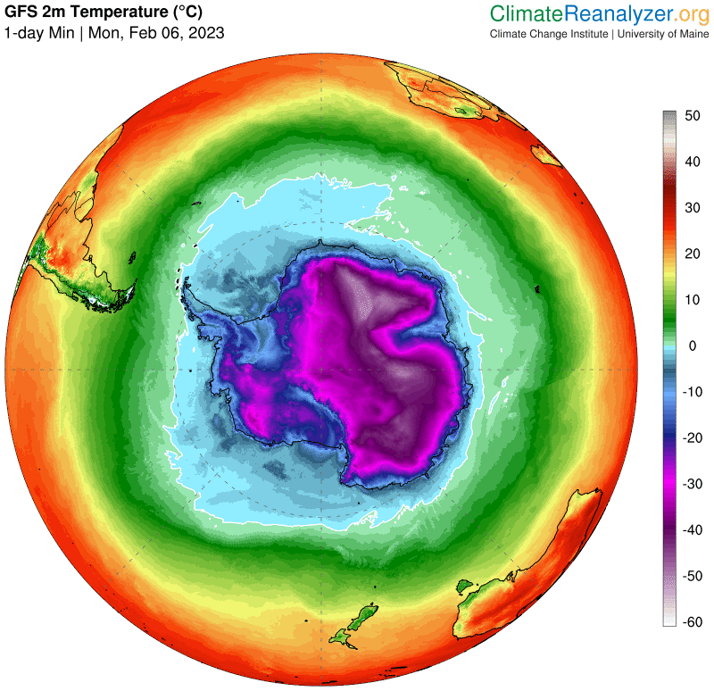
Antarctica’s Summer of Cold Temperatures Persists, Setting New Records - Cold Weather Report
COLDWEATHERREPORT.COMAntarctica is cold, but this summer has been colder than most, with record cold temperatures for January being recorded at various permanent international stations on the continent. Record January lows were...
Antarctica is cold, but this summer has been colder than most, with record cold temperatures for January being recorded at various permanent international stations on the continent.
Record January lows were set at Vostok research station, at the southern pole, and at the Concordia station.
-
5
-
1
-
-
1 hour ago, Chesil View said:
It would be interesting to know if any research has been done as to whether the time at which an ssw occurs ( ie early,mid or late winter ) has any consequential effect as to whether we get significant cold as a result. For Instance of those ssw that do result in cold for the UK do a higher percentage of early winter ssw produce cold outcomes or are later winter ssw more likely to produce cold outcomes.
So, when it comes to the relationship between SSW and the UK's weather, it's a bit complicated. There's no clear cut answer to whether early winter SSW or later winter SSW are more likely to result in cold or mild temperatures. A lot of factors come into play, like the timing, strength, and duration of the SSW event, as well as the conditions in the atmosphere at the time.
That being said, studies have shown that early winter SSW events tend to bring cold temperatures to the UK, while later winter SSW events are more likely to bring milder temperatures. But it's important to remember that each SSW event is unique and can have different effects on the weather. So, it's really hard to make any concrete predictions based on just one factor.
-
1
-
2
-
-
- Popular Post
14 minutes ago, Catacol said:Morning all - so where are we? I'm in bullet point mode at work - let's do the same here:
1. Bang on time - better charts for the second half of January are emerging.
2. Lagged impacts of MJO phase 6/7 likely to be having a positive impact.
3. Lagged impacts of +EAMT which have set the Pacific Jet on fire are working their way through to the Atlantic. This means amplification.
4. Ongoing Aleutian Low is guaranteeing strong wave 1 pressure on the SPV. Slightly less convincing shape of forcing on our side of the globe around Urals - but while the forecast comes and goes we certainly have some hope/confidence in sufficient Ural forcing that talk of an SSW will not go away yet.
Product =
a. Amplified Atlantic and the models are now sold on a mid atlantic ridge. Somewhat against what old hands have witnessed with these in the past, it is looking as though this one is going to produce a cold dig on the eastern side that will last longer than many and be colder than many.
b. Lagged impacts of MJO forcing will be adding weight to a more -NAO profile in general. This looks to being overridden by the overall strength of the atlantic, but what is happening in the meantime is a developing signal for the Azores High to ridge helped by MJO backing and overall amplification. The ECM op this morning was an eye opener in this regard today and maybe - just maybe - those of us who have kept saying "Scandy High" all damned season long so far won't be left peeling egg off our chins forever.
c. Overall - we have a snow event on the horizon. I don't think it classifies as "epic" - but given we are seeing more extreme events everywhere these days perhaps it is wise to rule nothing out. Some NWP runs recently are forecasting a pretty deep trough to pay us a 3 day visit in a northerly airstream and that has to be better than the atlantic mush we have had for the last 2-3 weeks since the collapse of northern blocking just after Xmas.
Where next?
1. Enjoy next week.
2. The fast firing Pacific Jet will swiftly retract. This is being shown in the forecasts. If any cold is to be long lasting we need to see a block emerge and gain traction BEFORE the lagged impacts of the weakening jet work their way through. If we don't get it - and on the balance of probability and historical precedent the odds are likely against it - then the atlantic will gain a hold once again for another phase. But maybe the ECM today can get us a decent Scandy High. Has to happen eventually.......
3. Much longer term - SSW or no SSW? That is the question. BA earlier was right - an SSW in late Jan probably means greatest impacts in March. Seen that before - bit disappointing for those looking for proper cold when it really counts - but such is the way of things. Still a watching brief here to see whether it happens at all.
4. Gloomy final point - if cold next week becomes a snap rather than a spell and we dont get a high lat block in place then the pattern will flatten exactly when MJO forcing supports a +NAO shape for the start of February. So - westerly first half of February before MJO enters more favourable phases in time for the end of the month. Maybe a combined MJO 6/7/8 on top of a split SPV for the very end of winter? That would be the final bite at the cold weather cherry.
For now - watching NWP developments with interest. Good that some of the forecasting of the last week or so has shown some degree of accuracy for this next phase.Catacol, I must say, your understanding of the weather patterns and their potential impacts is impressive. Your explanation of the lagged impacts of MJO phase 6/7 and +EAMT, as well as the ongoing Aleutian Low, gives a clear picture of the forces that are shaping the weather. The idea that we may see an amplified Atlantic and a cold dig on the eastern side, as well as a potential snow event, is well supported by the latest forecasts and models. Your insight on the fast firing Pacific Jet retracting and the need for a high lat block to emerge before the lagged impacts of the weakening jet work their way through is very insightful. It's also interesting to note your point about an SSW in late January potentially having its greatest impacts in March. Overall, your analysis provides a comprehensive and thoughtful look at the current weather patterns and their potential developments.
-
15
-
1
-
26 minutes ago, A Face like Thunder said:
Sad sight in local Tesco this morning with all fridges empty and notices saying that they had given up working in the heat. Presumably many food items thrown away as a result. I assume this is not an isolated incident.
Not isolated at all. Local tesco here too, the Aldi and Asda, fridges failed.
-
5
-
-
Just now, NickyB said:
Climate change is upon us and it’s not good

You can't stop the inevitable, but that's not for this thread.
-
Just now, chrisbell-nottheweatherman said:
This is a sad day.
Sad??
-
Heathrow hits 40C!
Whoa
-
6 minutes ago, Backtrack said:
Folks. Worth mentioning. The wildlife is really struggling.
if you get a minute, put some water out in the front and back gardens. I managed to attract about 200 honey bees yesterday to come for a drink. It was a remarkable sight.
Or was it the same Bee 200 times?
-
2
-
-
39.1 Charlwood.
Record gone.
-
3
-
-
10 minutes ago, Weather-history said:
Know this area not far way from me
I took a picture omw home...
-
5
-


Northwest Weather Discussion - Dec 2023 onwards
in Northwest Weather Discussion
Posted
Super strong gusts last night which woke me up from the squall line. It actually looked like a hurricane out there - Would love to find out the gust speed of that one.