


Lord Grogon
-
Posts
143 -
Joined
-
Last visited
Content Type
Forums
Blogs
Gallery
Events
Learn About Weather and Meteorology
Community guides
Posts posted by Lord Grogon
-
-
Blimey. Just been woken up.
its like a bloody rave out there. Constant flashes and booms!
-
 2
2
-
 1
1
-
-
WeatherPro app showing a gradual increase in temperatures today. Peaking at an impressive 14C, at the even more impressive time of midnight!
That doesn’t happen very often. -
Somebody made an interesting comment last night.
Usually for these big storms that track NW up the W side of the country, where you are a considerable distance from the centre of the low, to get big gusts, you are dependent on squall type events.
It was pointed out that the rain band that was quite showery, had "spread out" and merged into a more general front type setup. Hence without the squalls, the big gusts didn't happen so much. So for most of central and southern Britain, the max gusts were less than shown on the models. Assumption being of course that models didn't pick up the change in rain type, hence they overestimated the winds somewhat.
Further North of course, you pick up the tighter winds nearer the low centre, plus possible sting jet so stronger winds. Models seems to do just fine here, which is obviously where it matters the most!
Can't explain it anymore scientifically than this. But for somebody who has been watching storms for 35 years, it does make sense.
-
5
-
-
1 minute ago, Ice Day said:
I think there's a tendency for people to overestimate the wind speeds they've experienced. For my location, it's extremely rare to see wind gusts in excess of 60mph, probably only a few times a decade. In the 20 years I've lived here, I've only experienced 70 mph gusts on one occasion, which was the St Jude storm. So, this is notable for my location.
Agreed. Inland 70mph+ is pretty rare the southern half of the UK.
Even storm Eunice which was billed as the strongest storm for 10 years only hit 69mph in London.
-
1
-
1
-
-
1 hour ago, Harveyslugger said:
Yes I agree the wind field of this storm is huge.very impressive
It reminds me a bit of Storm Ciara. That had an amber warning over the whole of England and Wales.
Same concerns as well. A huge wind field with uncertainly up the last moment where the windiest bit would be. In the end there was a small wave that passed through generating higher winds in parts of C England.
-
Wow, a warning for the whole country. Impressive.
On a side point though, the Met Office really need to improve their warnings webpage. It's so fiddly and confusing.
-
5
-
-
51 minutes ago, Bats32 said:
Ouch, could we be looking at another 1987 here?
Not quite. These are gusts in kph. So if I'm reading correctly it's 70mph gusts along the coast. 50-60mph inland. With some inland locations poss a bit higher.
A nasty event, but nothing ridiculously extreme in terms of windspeed.
What's actually more impressive is the size of the windfield as it impacts all of England and Wales. Cetainly, you'd have the whole country under at least a yellow warning. Storm Henk this ceratainly isn't...
-
1
-
-
41 minutes ago, That ECM said:
Gem is interesting. What it does between 26th and 28th I’m not sure ive seen happen before in reality. Others may well be able to recall a time when it did.
other than another move away from a flat pattern there’s still much inconsistency. Fascinating.
 43 minutes ago, That ECM said:
Gem is interesting. What it does between 26th and 28th I’m not sure ive seen happen before in reality. Others may well be able to recall a time when it did.
other than another move away from a flat pattern there’s still much inconsistency. Fascinating.
Anything from a rabbit to a skipping lamb judging by these pics.
-
2
-
-
22 minutes ago, IDO said:
The noticeable part of the next week is upcoming potential destructive storms (to D6 gusts):
Seems to be a bit of a reversal. Trend until yesterday was to move the low pressure centres northwards, hence restricting the severest winds to Scotland. But the GFS has now reintroduced secondary systems further south. Given GFS tendancy to overdo low pressures, be interesting to see whether the trend is followed by the other models.
Oddly enough, I like windstorms. Earliest memories of "exciting" weather I have were of the big storms in 1987 and 1990. Just a shame of course they cause such havoc!
-
4
-
-
26 minutes ago, BLAST FROM THE PAST said:
19th Jan 1986…..anyway back from that?
BFTP
If I'm not mistaken, wasn't Feb 86 the imfamous "too cold for snow" month?
-
1
-
 1
1
-
-
“Don’t worry too much about snow chances. Small features will always pop up at short notice that the models won’t yet see”.
I must have read this comment a thousand times in some form over the last few days.
So what has changed? I know people may be a bit grumpy that the models are firming up on an end to this cold spell. But there seems to have been a complete collapse in excitement for the next week. Are people simply overreacting to Wednesdays low no longer going in the desired direction. Or is there something else?
-
2
-
-
God it’s hard work in the MAD thread.
They are very good at collectively talking up the doom and gloom. You’d think we were looking at a week of Tutg rain.
Think I need a stiff drink..
-
1 hour ago, frosty ground said:
Are you not interested in a rather large and compact storm then?
Snownado....
-
1
-
1
-
-
1 hour ago, danm said:
Not just Kent, many across the south/SE got a heavy snowfall with several inches:
We got 5 inches of laying snow here. Only time I have seen more in 24 years of living in London was the infamous Feb 2009 Thames streamer event.
It gave more snow than both Dec 2010 or the 2018 BTFE.
Point worth making. It's almost impossible to get nationwide snow cover off a single event. It just doesn't happen. Hardly ever does with rain, let alone snow. Weather systems will hit specific areas. Some will get lucky, others won't. Dec 22 was jackpot for us, but we were very lucky.
There's a famous photo from Jan 2010 that showed the whole country blanketed white. I recall at the time how dramatic it seemed given how rare snow had been during most of the 2000's. But that happened because the country had been stuck in a cold spell since mid-Dec 2009. Nearly a month of snow events had occured in the month leading up to that photo.
-
7
-
-
So my non-technical take on what will happen. Based on nothing more than my direct experiences, plus reading this site.
1) It will get much colder over the weekend. There will be much talk in the media of "stiff northerlys" and "arctic blasts"
2) A few places in the north will get snow showers. But on the whole most places will remain dry. Some will grumble at this, but others will maintain that we should keep the faith.
3) There will be much talk of a big midweek snow event. But ultimately it will trend southwards and miss the UK.
4) There will be louder grumbles, but others will say "at least it is still cold".
5) A much bigger low will approach from the west. There will be talk of "battleground scenarios" and "midlands north event"
6) The low will pile through. There will be snow on the leading edge that will produce dramatic pictures on the news. But overall it will soon become a rainy/slushy mess. It will mark the end of the cold spell and people will be sad.
7) Others will say "Doesn't matter. Background signals are supporting an even better cold spell opportunity next month." There is much rejoicing and the chase is resumed"
Original post: https://community.netweather.tv/topic/99760-model-output-discussion-colder-but-how-cold-and-for-how-long/?do=findComment&comment=5006917-
1
-
-
- Popular Post
- Popular Post
So my non-technical take on what will happen. Based on nothing more than my direct experiences, plus reading this site.
1) It will get much colder over the weekend. There will be much talk in the media of "stiff northerlys" and "arctic blasts"
2) A few places in the north will get snow showers. But on the whole most places will remain dry. Some will grumble at this, but others will maintain that we should keep the faith.
3) There will be much talk of a big midweek snow event. But ultimately it will trend southwards and miss the UK.
4) There will be louder grumbles, but others will say "at least it is still cold".
5) A much bigger low will approach from the west. There will be talk of "battleground scenarios" and "midlands north event"
6) The low will pile through. There will be snow on the leading edge that will produce dramatic pictures on the news. But overall it will soon become a rainy/slushy mess. It will mark the end of the cold spell and people will be sad.
7) Others will say "Doesn't matter. Background signals are supporting an even better cold spell opportunity next month." There is much rejoicing and the chase is resumed"
-
34
-
5
-
4
-
51 minutes ago, Man With Beard said:
Member 27 of the ECM ensemble set, next Thursday. Foot of snow for many. Just for fun!

just trying to cheer a few of you up

Geez. Keep that one away from the Daily Express.
-
8
-
1
-
-
Can I just jump in quickly to say thank you to the Netweather team for the Model Highlights thread. It is a great idea.
I like reading the main model thread, but it does get rather swamped this time of year with bickering and hyperbole. I know Netweather have tried in the past with different ideas such as separate threads that haven't always worked. But this method is really useful!
-
1
-
1
-
-
Starting to get going here now. Hoping it doesn't get too bad as wifey is on the other side of the river at Bluewater with the kids.
I did warn her, but she tends to laugh at my slightly creaky weather forecasting skills.
-
1
-
-
23 minutes ago, LRD said:
Yep. And then when anyone dares go against the 'positive' grain they're often jumped on
On the flip side there are also some trolls who love to wind people up so, to an extent, it works both ways. Feel sorry for the mods who have to police it all. And I say that as someone who has crossed swords with them on a couple of occasions
The main issue with Netweather is when you go into the community page, 90%+ people are always in the model page. So it naturally draws people there as it is "where the action is" so to say. Hence you get the conflicts between the objective posters and the rampers. Netweather have tried all sorts of things over the years to split discussions, but it never seems to work.
It's a fun page to read, but it does suffer from similar issues you get in a lot of social media i.e. hypersensitivity and attention seeking. The rule I have picked up over the years is; enjoy reading it, but don't take it too seriously. A lot of people on there are probably not as clever as they think they are, or from a slightly fairer angle; meterology is bloody complictated! If you are after objective opinions on the weather, stick to a few knowlegable posters (Catacol, Tamara, Nick F etc) and ignore everything else.
-
1
-
-
8 minutes ago, A Face like Thunder said:
So, two weeks tomorrow, and you heard it here first.
Nah. It just looks like a roided up version of Storm Ciaran. Just avoid the Channel and coasts and you'll be fine.
Now, the one a couple of days later however....
-
6
-
-
Dumb question from an ignorant fool.
Why do models trend low pressure systems south?
Is it simply some sort of empirical bias? i.e. they don't always all trend south, some go the other way. But it tends to pop up in the higher profile situations where more people are watching.
Other point is that is if they do go south, why don't the people who program the models adjust for it over time? Afer all a model is just a big computer program that should use ever increasing levels of historical data to improve it's accuracy.
-
2
-
-
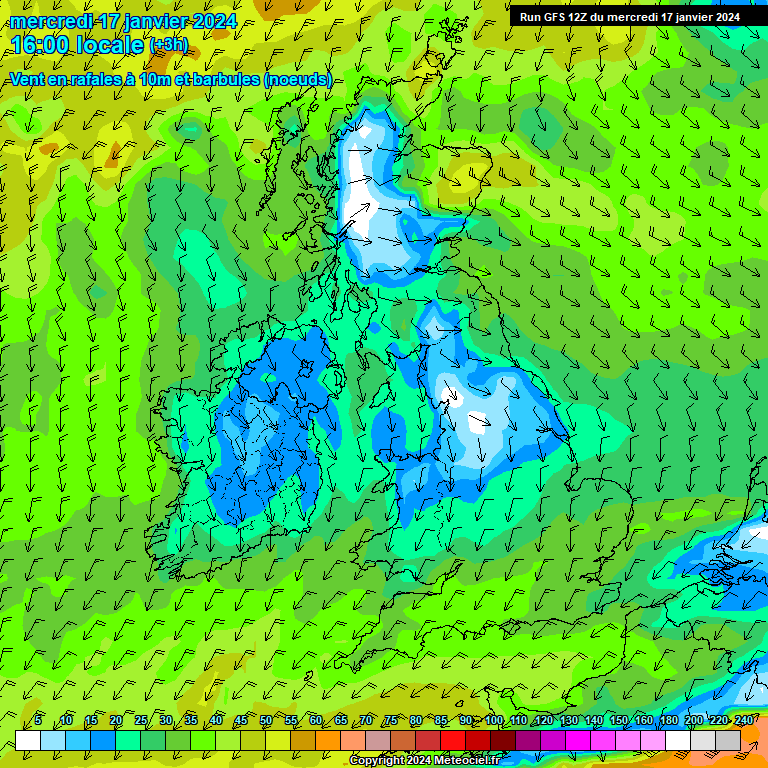
3 minutes ago, matty40s said:
According to this French amateur, yes....
Odd. The discussion here this afternoon (including Tamara who clearly knows her stuff) basically said there wouldn’t be a sting jet. Wrong type of depression apparently.
-
1
-
-
Hmm. BBC news article saying a “metre of rain” has fallen. But the article detail then quoting amounts of 100mm (ish).
so either the UK 24 rainfall record has been shattered by a factor of 3, or somebody there needs some basic maths lessons!

-
6
-


Storms and Convective discussion - May 2024
in Storms & Severe Weather
Posted
Gee. Now I see why.
somewhere under all that angry purple stuff is me.
Still flashing like mad.