


SP1986
-
Posts
8,589 -
Joined
-
Last visited
-
Days Won
1
Content Type
Forums
Blogs
Gallery
Events
Learn About Weather and Meteorology
Community guides
Posts posted by SP1986
-
-
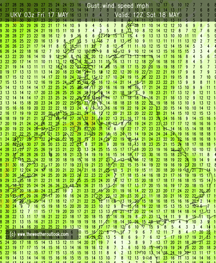
who knows if the UKV is exaggerating windspeeds for the NW coast but if not, I'm off to bury myself away somewhere.

-
 4
4
-
-
4 minutes ago, johnwirral said:
The gusts could be 70-80 and the wind direction funnels then down the estuaries, would not right this off yet.

yes, this around 70-75mph seems the maximum peak for our area.... probably similar to Arwen but a little more intense on the back edge of the low. Quite a lot less than Storm Kyrill in 2007, which saw wind gusts near 100mph here. Hopefully the weakened trees have gone and no more will fall.
-
4
-
-
5 minutes ago, Weather-history said:
Manchester TAF is going for 60kt gusts
Temporary
from 18 at 11 UTC to 18 at 15 UTCWind 35 kt from the West/Northwest with gusts up to 60 kt
same for Liverpool, 60 knots, or around 70mph. Not that unusual on the coast as far as significant storms go, but much more unusual inland, so could be interesting around your way, does westerly wind hit your area hard?
-
2
-
-
19 minutes ago, Miamay said:
Still touching in the amber warning
we should be ok, a few days ago when some models were showing 90-95mph gusts on the coast around Wirral/Liverpool I was potentially considering not going to work on Friday, as the peak would have been right on the 'commute' time, but it looks now like it won't be an issue, I'd rather not be forced to miss work to be honest. Still it'll be an arduous task walking against 55-60 mph gusts!
-
3
-
-
18 minutes ago, Snow free zone said:
FWIW latest icon brings the NW right into the firing line of some of the strongest winds, as it has the low further N. Also worth looking at the period early tomorrow afternoon, there has been fairly consistent modelling of a 2 hr period of much stronger winds for the fylde coastal strip down towards the mersey estuary. This seems to be happening as the low exits into the north sea. Worth keeping an eye on.
There are still many options open. What you describe sounds like the developing sting jet feature which it seems like ICON makes quite broad.
However thankfully I think this will be to the south from our perspective. I do think we will dodge the bullet so to speak with regards to the strongest windspeeds.
The south Midlands and east Anglia though.. Ouch
-
3
-
-
Its been very windy overnight, and I wouldnt be surprised if Storm Dudley actually surpasses the strength of Eunice overall in our region. It does seem to have changed southwards a little, perhaps taking the potentially damaging winds away from our region, which is no bad thing.
Of course it also increases the chance of snowfall for more of the region.. Lots coming in the next few days
-
4
-
-
3 minutes ago, CreweCold said:
UKV still showing places Like Liverpool, Manchester, Stoke-on-Trent at risk of 70-85mph gusts for a short time.
Definitely reequires the Amber warning we have. It will likely stay as Amber too as I see nothing to suggest a red warning is necessary away from the coast of the Severn estuary.
From a personal point of view, I finish work right at the peak of it hitting the region on Friday which is going to be interesting.
-
3
-
-
2 minutes ago, Chris.R said:
I’m not sure. I can’t get my anemometer high enough in this house so it under reads but I reckon around 70. I’m looking at Saturday. Potential for some snow in an evaporative cooling event. A low crosses the coast around Formby and anywhere north of that could have a nice event. A tiny shunt further south and all of Merseyside is in the game.
At the moment the trend seems to be shifting north, thus moving a significant snow event away from our area, however there will be showers piling in behind and I'll bet some of them maybe have a wintry element, as well as convective potential. I wonder what ESTOFEX forecast will look like on Friday?
-
4
-
-
If it wasn't for the timing, for Wirral, I'd class this in an IMBY sense as a infrequent occurrence.... 70-80mph gust in strong storms happen every few years here so it's not a very rare thing.. and yes it does cause some minor damage, and these types of storms are becoming more frequent, but, of course the biggest factor as mentioned above is the timing, only the 2007 storm has occurred in daylight hours, and unfortunately a few were unlucky.. but generally they have tended to occur at night which has limited casualties..
-
5
-
-
1 minute ago, Chris.R said:
I’m not sure. I can’t get my anemometer high enough in this house so it under reads but I reckon around 70.
makes sense, probably very similar.
-
6
-
-
11 minutes ago, Chris.R said:
Still nowhere near Arwen here though;That really was insane.
what was your top gust for that storm.. I'm not sure what it was 100% but I was going on the official figure of 66mph, so maybe have been a bit more, but not by much. Eunice will probably be quite similar to Arwen in that respect, and similarly short lived.
-
5
-
-
Just now, WillinGlossop said:
Normally if it’s that noisy it’s +60mph… always remember the snow in 2018 and the winds making it drift… such loud creaking of house…that night was +70 mph… it’s gusts and comes and goes but the squall line approaching I’m guessing it’s associated
True that is an associated factor, the squall line, that could be producing some random straight line gusts, above the average. Well anyone with gusts above 50mph could well see more uprooted trees tomorrow, especially after the heavy rain of earlier.
-
5
-
-
7 minutes ago, WillinGlossop said:
I’m guessing 60-70mph gusts quite loud
wind definitely seems stronger than it really is. I remember walking by Lake Vyrnwy in Wales, in an enclosed but exposed location, and crossing the top end of the lake, it was gusting 39mph but it was difficult to stay steady on your feet and it seemed very strong, but the hand held anemometer only got to 40mph.. I think your gusts probably sound louder than they are in reality... they sound absolutely horrendous here, but I know they're not anywhere near 60mph, despite the floor vibrating and being on the coast in an exposed location..
it's worth noting that for here the official top gust in Arwen was apparently 66mph.. and it brought down lots of trees and caused structural damage... that why Eunice could be a huge problem.
-
6
-
-
wind has picked up quite markedly in the last hour.. strong gusts rattling through, probably up to about 55mph... you can add about 10-15mph on top of these for Eunice.
-
6
-
-
27 minutes ago, SnowThunder said:
So is this going to become the norm thanks to climate change ? Winters that are more like Autumn with months of overcast skies broken up by a treadmill of frequent storms ?
Probably wont be far from the case to be honest.
-
3
-
-
Thankfully, perhaps, the GFS has backed off extreme gusts for coastal areas.. Obviously that wont be any comfort to those in the southwest but any avoidance of structural damage is a positive.
-
3
-
-
The storm today has so far been a typical winter storm, im not sure if its meant to increase later this far south.. Max gust has been around 45mph so nothing extreme. That said we were not in the high risk area. Eunice may be more of a problem but its unclear yet whether the severe wind will impact our region for certain... We will know come tomorrow
-
8
-
-
With all the rain forecast, trees will be easily uprooted. 55mph gust can uproot a shallow rooted tree. If Eunice delivers a nasty wind storm to our region there will be lots of trees down.
-
4
-
-
If it takes the track of the UKMO it looks like it will be similar to 2007 with the strongest winds being in the northwesterly phase due to rapid cyclogensis. Back then there was lots of damage to trees and buildings including a collapsed building. Hopefully it wont be that severe.
-
5
-
-
Currently 5C, birds are singing the dawn chorus. The low was 0.8C. Down south is rather frigid this morning.. -5C to -7C in the central south/southwest
-
6
-
-
5 minutes ago, Frigid said:
Currently -4c at Manchester Airport. The coldest night of the winter so far. Could it reach -5c or below..
I think so, maybe even -6C if the cloud stays away.
Here on the coast it's 0.8C, but appears to the stable (which means it'll be rising soon).. high cloud visible too.
-
6
-
-
1 hour ago, Nordic Freeze said:
Remember it well, started as rain here then by the evening turned to even heavier rain. Standard.
you got 10 flakes of sleet actually lol. It was an absolute let down for us on the costa del Wirral.
Currently 2.8C and wee bit chilly. Might get an early frost before the temperature rises later in the night.
-
5
-
-
2 minutes ago, Had Worse said:
If you see any with legs in the air, that'll be an Avian flu case.
if they get a handle on the problem, will it be a brief case?
-
5
-
-
This so far, has been a really weird winter... lowest temperature was a few days ago, when we went ot -0.6C.. with some frost, but in town it was only 1.1C meaning the areas southwest of the town have not yet gone below 0C this Autumn and winter.. let that sink in... ! This morning it fell to 2.3C first thing. It's currently 5C, quite chilly really.
This winter has been weird for this reason.. lots of high pressure, lots of clear skies.. virtually no frost. Even if there has been a relatively warm airmass hanging around the high pressure, inversions should have delivered frequent frosts and cold.. but alas nothing.
There is of course plenty of winter left, almost half of it, but I was expecting a rather cold winter by this point, so I'm quite surprised so far.
-
7
-


.png.a5b9eff637769fbe7817b2491e9cce4c.png)
Storm Eunice - 18th February
in Storms & Severe Weather
Posted · Edited by SP1986
As the storm moves east, after it has pummelled southern areas, and is causing issues in the southeast, the UKV wants to cause problems in the northwest of England.. obviously this is a bit imby, and may not happen, but there is not much representation on here of the back edge effects for the northwest, and north Midlands. UKV, if you can trust its projections showing a swathe of winds approaching 85mph on the coast, and around 70-75mph down the 'Cheshire Gap', no doubt due to funnelling. It could of course be way off the mark, but the potential is there.