


skifreak
-
Posts
3,086 -
Joined
-
Last visited
Content Type
Forums
Blogs
Gallery
Events
Learn About Weather and Meteorology
Community guides
Posts posted by skifreak
-
-
19 hours ago, johnholmes said:
Never mind, according to this latest release from UK Met Spring is getting warmer!
http://www.metoffice.gov.uk/news/releases/2017/warmer-springs-but-easter-frost
Fits my statistics over the past 20 years especially comparing them to RAF Finningley for the 1960-90's
Apologies for taking this further off topic, but I think a lot of farmers and crofters in the North of Scotland would find that hard to believe - there is plenty of comment that the seasons appear to be getting later, Northernlights has posted on numerous occasions over in the Scotland weather thread that turnout dates for cattle on the Moray Coast have been getting later and later recently.
So is there something more nuanced going on? Well if you look down that Met Office article there is a graph which from an admittedly casual glance looks to suggest in the latter part of it (2000 onwards) that March frosts are reducing and Spring frosts as a whole increasing slightly - meaning colder conditions are shifting into later spring. This would also fit with what's been seen on the ground in the West Coast ski areas and on CairnGorm Mountain. It's also been hypothesised that the later occurrence of spring cold spells has contributed to the resurgence of snow patch survival on the Scottish mountains through summer.
-
 6
6
-
-
I wouldn't discount the cold Northerly option, it's been showing up quite a bit in various operational runs, there's been at least some members going for it in every GFS ensemble set I've looked at over recent days. The winters that panned out as similar to this in terms of snow in the Scottish Ski Areas were 2012 and 1998, in both cases the best conditions of the season came in late April onwards into May in the Northern Cairngorms. I'd say it's almost the form horse here, if it goes the other way and we do get a high pressure dominated April into May, I'll certainly be hoping it pans out like 2003 and not 2007 thereafter!
Just to illustrate the point, some photos looking down / up Coire Cas on CairnGorm in mid March, then mid May 2012:

-
5
-
-
There's a distinct air of 2012 about in terms of the snow cover on the mountains and the repeated suggestion of where the weather is going as we move towards mid April!
-
2
-
-
10 hours ago, scottish skier said:
Have to say I'm enjoying spring.
So moved on from winter now.
Maybe it's me, but have snowdrops not lasted a long time this year?
They came out early along the River Ness in Inverness and still in full bloom!
-
1
-
-
I wonder how high the temperature roller coaster could climb tonight in NE Scotland!
-
1
-
-
Linnhe and Alpha Tows open at Nevis Range. #powday
-
7
-
-
The cars stuck on the incline at Castlecary, if it was upto me any car getting stuck and blocking a major road that didn't have either snowtyres fitted or a shovel onboard should see the driver prosecuted, Then people might either prepare their cars for winter or baldytyres might stay at home. I'd take no prisoners with the idiots that have made everyone else prisoners on the M80 this morning.
-
3
-
-
-
Beginning to look wintry in nature in Leadhills, but a soaking to start isn't ideal for getting skiable snow on the golf course for the Ski Club.
Updating cam: http://www.winterhighland.info/cams/lowtherhill/leadhills.jpeg
-
- Popular Post
- Popular Post
13 minutes ago, 101_North said:Expecting the usual disappointment here but we'll see...
Currently around 101's house:
-
10
-
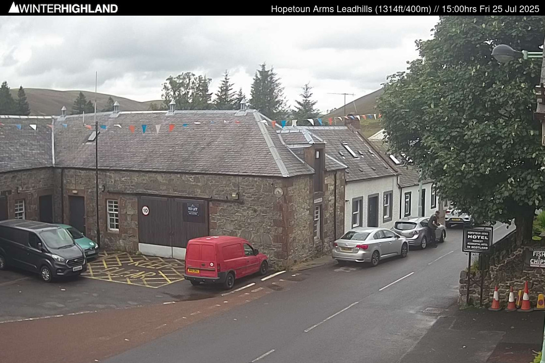
This would have been a good couple of days to have been in Leadhills or Wanlockhead by the look of things. Currently the calm before the snow storm hopefully on the village webcam at the Hopetoun Arms at 400m:
Updating image: http://www.winterhighland.info/cams/lowtherhill/
Don't expect to see much on the webcams actually on top of Lowther Hill tomorrow - the batteries are rather flat after too much dull weather recently and the wind will be blasting the snow straight at the cameras even if they come on (and as they work of a battery / solar combo de-icing heating is a bit minimal by necessity).
-
1 hour ago, Ross B said:
I'm officially on a snow day tomorrow now, not risking the foot of snow on the m74 even though I kind of want to test the car out in the snow!
I'd be inclined to try the B7076/B7078 on the assumption the overwhelming majority will stay on the '74 where your car makes no odds if everything has come to a stop up ahead.
-
1
-
-
44 minutes ago, ruzzi (snowboy) said:
In my head I had made some sort of similarity with the snow storm of 26th / 27th February 2001 and this approaching 'snow' storm, however upon checking it's not really similar at all. It was my all time best snow day.... 60cm of level snow and drifts so big that I could walk onto the roofs of cottages and over the top of transit vans. Don't know if anyone remembers it?
Similar dates in 2010 brought huge snowfalls under a stalled occlusion to the Northern Cairngorms and Strathspey, I think the bulk fell on the 25 and 26th from a quick look at old charts. As for 2001 I recall a huge fall on CairnGorm overnight Tuesday 6th into Wed 7th March and it fell in mostly light winds after a stormy Tuesday, however a synoptic pattern that stood out from 2001 that brought another one of that years huge dumps was this in early Feb:
A similar 'triple stack' showed up in the models for late Feb 2010, the charts didn't end up quite as neat and tidy as those three lows lined up, but the effect was similar:
Something in the order of 72 inches of snow on the CairnGorm plateau from radar returns in 2 and bit days - leading to this at Glenmore:
-
7
-
-
8 hours ago, Ross B said:
You'll end up with more snow than most of the ski centres have... looking forward to the photos tomorrow!
We are going to see snow in and around parts of the Central Belt, perhaps carnage on the higher and in particular more exposed parts of the A74 and M74, very high winds across much of England -> All leading to big media coverage, spectacular snow footage on TV, big interest to going skiing generated and realistically not one single skiable run at the five Highland areas this weekend.
The Ski Areas will miss most of the snow, not get as severe drifting as the stronger winds are further South, then be subjected to silly Munro Level temperatures, incessant rain (at least in the West) and Storm Force SW'ly winds on Saturday.
Meanwhile after 56 inches of snow in 36hours (thats when they passed the 500 mark for the season and its now at 556) this is Kirkwood in California, the lucky few who've been trapped in Kirkwood for the past 3 days as State Route 88 remains blocked by snow on one side of Kirkwood and by avalanche and mudslide debris on the other!
-
8
-
-
Hopefully there will be some snow on the ground and a bit of brightness on Lowther Hill tomorrow because the webcam batteries appear to have gone flat - just when something fairly epic might happen on Thursday!
-
A couple of images from this morning and at dusk from the new Summit Webcam on Aonach Mor in the Nevis Range. Check out the updating images at http://www.winterhighland.info/cams/nevisrange/ .
-
7
-
-
14 minutes ago, winterof79 said:
Instead I now have to read one liners with no charts posted to verify posters claims that the met are wrong and daffodils are pushing up.
Well the Met Office updates were going for the likelihood of colder than average conditions in their extended outlooks, The opposite has been getting progressively more likely with every run, as can be seen in one go from the Aberdeen 850hpa Temp ensembles. A quick flick through the GFS 12z is a horror show for Scottish Ski Areas not least because after a prolonged spell of settled conditions we could see the peak period of half term holidays being wild and wet!
-
1
-
-
19 minutes ago, Ravelin said:
What was the year recently where the resorts were having real problems keeping running because of the sheer amount of snow and having to constantly dig out the lifts?
It was 2013/14 - the season the Jan webcam image was from. It snowed every day at Glencoe from start of Jan for over 60 consecutive days!
The winter of 2013/14 as a whole was milder than the very poor 2007 and 2012 seasons, but brought at least as much snow as 1994 to the Western mountains.
-
2
-
-
- Popular Post
- Popular Post
I posted this on Winterhighland but will post it here as it's certainly noteworthy. A few may have read 'Scottish Skiing is doomed' type reports last week or seen a similar story and an extraordinarily negative interview from the general manager of CairnGorm Mountain Ltd!
There is no doubt we have had an exceptional run of 5 months benign weather since the start of meteorological autumn, but the following stat puts a wee bit of perspective on the temperature last month.
Mean January temperature anomaly for Scotland with respect to the 61-90 average and comparative webcam images from Glencoe from 30th January (clear view on each year):
January 2017: Temperature anomaly +1.5°c
January 2014: Temperature anomaly +1.5°c
-
11
-
1 hour ago, Hairy Celt said:
Freezing here, not going out to check the thermometer till I've found some clothes.
Don't be a big girls blouse!
-
2
-
-
Moon is out, largely clear skies above Inverness as far as can be seen from the city centre where the temp is +0.7ºc. Cold enough for the footbridges to be icy...
-
2
-
-
16 minutes ago, skifreak said:
IIRC it was similar setup up to the huge snow event in Aviemore and surrounds in 2010 when a warm sector occluded out slowly across Scotland then the wrap around basically stalled across the Central Highlands, it just puked snow for a couple of days!
OK temperatures in the North Atlantic were similar, but synoptics no - think I was thinking of the snow from one event and weather setup of another, here are the charts of the two days of constant snowfall in and around Aviemore:
Here's the aftermath as seen at Glenmore at 1100ft on Saturday 27th Feb 2010:
More Pix (and note that radar returns indicated around 72inches of snowfall at high elevations in little over 48 hours): http://www.winterhighland.info/pix/pixalbum.php?pix_id=609
[EDIT]
Does anyone have the fax charts from that period, I recall there was a couple of instances of 'upside down' lows where the frontal systems were to the North of the low centre as the lows had formed and moved in a Westerly direction.
-
5
-
-
1 hour ago, Northernlights said:
A question for the more knowledgeable on here just had peek on the model thread and saw where one chart for the 13th of February had -8 850 air heading east over the mid north Atlantic meeting -8 850 air coming in from the east so it would appear that we cannot escape cold air from either direction. Has this happened at lot in the past or is it fairly rare?
IIRC it was similar setup up to the huge snow event in Aviemore and surrounds in 2010 when a warm sector occluded out slowly across Scotland then the wrap around basically stalled across the Central Highlands, it just puked snow for a couple of days!
-
3
-
-
Not a bad day at the Lecht, thought the snow is rather thin, it's at least managed to get open and the Sun was out for chunks of the day though the wind and cloud increased through the afternoon. I see from the Aberdeen 850hp ensemble graph that the 12z GFS went off on one today - should I look at the model thread?
Pix: http://www.winterhighland.info/pix/pixalbum.php?pix_id=1211
-
8
-


Model Output Discussions 12z 08/03/17
in Forecast Model Discussion
Posted
The I am out of the country model says it will snow at the end of April into the first week of May!