


Just Before Dawn
-
Posts
918 -
Joined
-
Last visited
Content Type
Forums
Blogs
Gallery
Events
Learn About Weather and Meteorology
Community guides
Posts posted by Just Before Dawn
-
-
1 hour ago, Schnee said:
Interesting watching how next week is progressing in the models. Must admit, i'd rather not have the snow and super cold temps that follow. Aside from having a driving job, I don't think the boiler and pipes will cope.
I’ve got to drive from Louth to Penrith on the evening of the 15th, then back on the 16th, so I’m giving the snow event on the latest ecm run the side-eye right now.
-
10 minutes ago, Hurricane Andrew said:
seems like we have escaped the worse but river lud running high but the rain still falls
I think the post-2007 flood defences have done their job well - it looks like the rain is going to peter out over the next two or three hours, in which case we've got away with it (touch wood). Not that it feels that way if you're driving in or out of town - surface water is everywhere.
-
 1
1
-
-
Had to go out to check some sites out on the Lincs Coast this afternoon - the surface water flooding isn't too bad (though getting worse) but the Agency were shutting all the flood gates ahead of high tide tonight and I'm not surprised given the Easterly gale blowing through. It seems to be worse further west - Horncastle is a real mess at the moment.
-
1
-
 1
1
-
 1
1
-
-
Significant increase in the number of flood warnings and watches in our patch overnight from the Lincolnshire fens to the eastern dales. Today’s going to be a long day for a lot of us.
-
Its so marginal here - still rain in Louth, though its starting to get a bit sleety but just driven towards Market Rasen and up Caistor high Street over the top of the Wolds and its all snow now blowing around in a strong NE. I'm not sure how long this is scheduled to last but altitude, even fairly modest gains, making a huge difference. Driving back I transitioned from snow to sleet to rain over about 3 miles and a 150ft drop in altitude.
-
2
-
-
1 hour ago, reef said:
Absolutely miserable here today, rain and sleet all day and a temperature of about 2C.
I'm beginning to wonder if decent snow is all but extinct here now. Northerlies, easterlies, frontal, it makes no difference it seems! Even when the temperatures and synoptics look good (like the 2018 BFTE) it doesn't deliver.
We've gone from an average of 15 days of lying snow annually on the 1961-1990 average to just 4.1 in the last 12 years.
Lets hope tonight gives something when winds back north.
Agreed Reef - its been a complete washout today here in Louth with not a flake to be seen and light rain most of the day. It's seemingly getting harder and harder to get synoptics in place to deliver snow to the east coast at sea level now - the last decade has been worse for lying snow than the late 90s early 2000's and they were miserable. Lets see what the overnight period brings, though I'm pretty skeptical here if I'm honest.
Nice to see that others are getting it though. Keep the photos coming, at least I can live vicariously via the west of the region.
-
1
-
-
21 hours ago, mike57 said:
I wonder if we will see snow at the coast. Sea Surface Temp is still at around 10c this may be a bit to high to allow snow here. Having said that December 2010 was deepest snow here over the 16 years we have lived here, it just kept piling up. I wonder what SST was at the start of Dec 2010
I can't tell you the actual SST but according to the NCDC the SSTs for the seas around the UK in December 2010 were colder than the 1971-2000 December average.

-
1
-
-
It’s getting pretty blustery here in the Lincs Wolds - fortunately I haven’t been called out yet, but Donna Nook has recorded a 53mph wind gust already, several hours before the worst of the wind is due to arrive here.
-
1
-
1
-
-
I should probably go to bed given that I’m on call from 6am, but I’m hanging in there for what promises to be a shipping forecast for the ages.
-
4
-
-
14 minutes ago, East_England_Stormchaser91 said:
I’m not ruling out somewhere such as Wattisham, Wainfleet, Shoeburyness, Weybourne, Marham or Lakenheath as the storm exits and with the sting jet potential. Could easily see a 90-100mph gust at one of these if the worst does happen.
If that does happen then somewhere in The Fens is a very decent shout. Either that or one of those automatic light vessels in the S North Sea that you only ever knew existed from the shipping forecast.
-
1
-
-
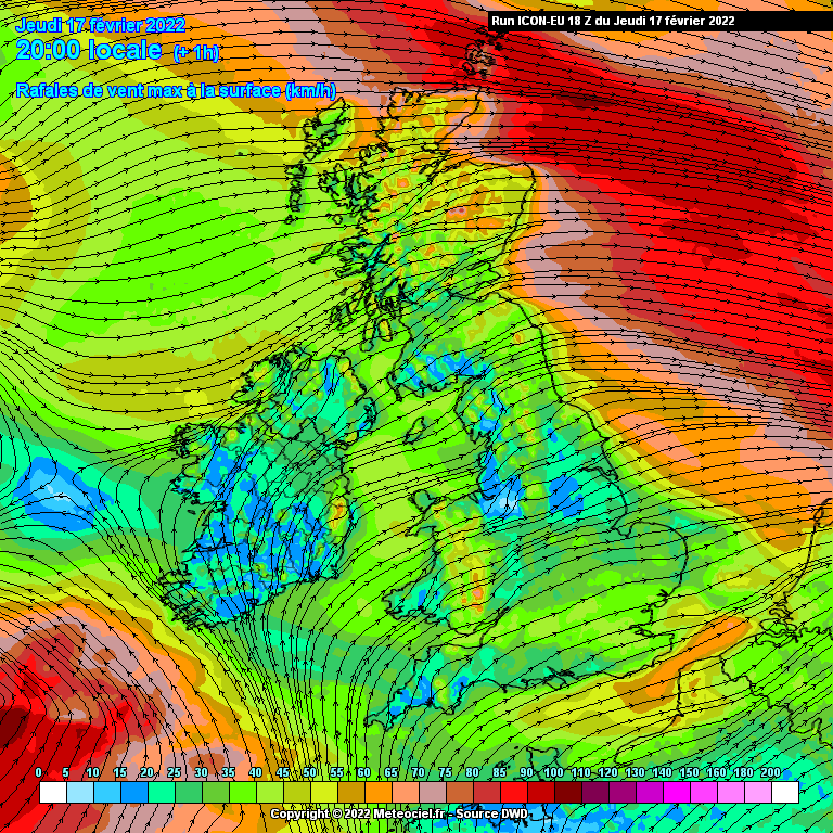
5 minutes ago, Mike Poole said:
ICON-EU 18z take on it, looks a little further north and stronger to me than the 12z suite:
Looks like I picked the right week to service the chainsaw.
-
3
-
-
12 minutes ago, East_England_Stormchaser91 said:
Exactly my point. The emergency services are already pushed to their limits without this imminent chaos that is about to ensue. They need to also start preparing.
We have been - since yesterday morning. That said, the longer it takes to get accurate public warnings out, the harder work we have convincing people who aren’t as plugged into the weather like we are to change their plans and make preparations.
-
5
-
-
33 minutes ago, Man With Beard said:
I don't envy the Met Office this morning. Put out a red warning for a massive area, and if the storm isn't too destructive locally people will call it hype and ignore it next time. But if the sting jet develops 30 miles away, then people will be up in arms if the red warning hadn't gone out early.
Oh yes, 50 miles is easily within margin for error right up until tomorrow.
For those of us who work in emergency planning, this is a subject of constant debate. I’m lucky, I only have to worry about the people who work in my organisation (and only in my region) but even then, timings of warnings and briefings, particularly for adverse weather events, keeps me up at night. You’ve got to go early enough to inform and allow people to organise themselves or change their behaviour but not so early that the warnings become background noise, or worse, become redundant because of changing circumstances. The US National Weather Service have done a huge amount of work on this and there are lots of interesting papers on the subject out there. FWIW, I’m getting briefed at 11:00 am this morning, but we issued our first advisory last night. I expect to be very busy this afternoon and tonight.
-
2
-
1
-
-
The shipping forecast issued half an hour ago is giving an early indication of what to expect on Friday - for Sole, the sea area first likely to feel the effects of Eunice the forecast is for a very high sea state - that’s a swell of between 35 and 42 feet. It’s likely to be phenomenal at the next update with a swell in excess of 42 feet. That’s pretty rare.
-
2
-
1
-
-
8 minutes ago, richie3846 said:
Maybe I'm biased because I have to work outdoors quite a bit. Best winter in years from a personal perspective, no fun in getting soaked every day, no fun in subzero temperatures, and definitely no fun if it snows.
I hear you. I work outside (I’m on call on Friday) and this winter, dull as it’s been has at least been dry. I don’t mind working in snow but going out in driving sleet and rain in 4 or 5 degree temps gets old very quickly these days.
-
6
-
-
11 minutes ago, StingJet said:
A quick check on the inshore waters forecast (following 24hrs) - Pretty much all inshore water areas expecting F8-F10 that are affected by Eunice .. the one and only exception being Lands End to St. David's Head, including the Bristol Channel ; F9-F11 , This peaking on Eunice's approach to Wales / north west england on Eunice's southern flank , the Sw'er
They’ll make interesting reading tomorrow I think, particularly the sea state forecasts.
-
4
-
-
Impressive storm between Doncaster and Scunthorpe - not least in terms of the rainfall amounts.
-
2
-
-
Pretty weak this afternoon. A few light flurries but we're in a big gap between the Wash and the stuff coming on-shore in East Yorkshire.
I guess we'll see what the evening and overnight period brings.
-
1
-
-
Showers here have definitely pepped up over the past hour - they're still putting down very light snow, but they're more frequent and longer in duration.
-
7 minutes ago, Mikey Skins said:
As soon as that Amber warning popped up... it all went pear shaped.....
Had about 4cm here and it is starting to thaw already.......
Disappointed that they showers never got their act together and banded up. Just 5 min bursts with breaks in the cloud.....
Exactly the same here, except for the 4cm, we've had half that.
-
Showers are still piling in, but they're fairly light and moving through pretty quickly - we're right on the south east edge of the amber warning zone, so I suspect most of the heaviest stuff is moving through to our north west.
-
1
-
-
Lincolnshire Police reporting that that the A158 between Horncastle and Partney and the A153 between Louth and Horncastle are closed because of drifting snow, and the A157 between Wragby and Louth is passable by 4WD vehicles only.
-
4
-
-
Here in Louth we've had what might best be described as an 'enhanced dusting' - maybe half an inch, but you don't have to go too far to our west to find bigger totals. The wind has dropped off but it's still breezy - there are some grim road conditions in the Wolds by all accounts.
-
3
-
-
Graupel has now turned to light snow - too light to be settling, but it's starting to come down.
When the showers beef up later, There shouldn't be an issue with it settling.


Storm Isha, Amber ⚠️
in Storms & Severe Weather
Posted · Edited by Just Before Dawn
The shipping forecast should be lively later tonight. It's been a while since we've had a phenomenal sea state.